Author: Tracy Cozzens

  • New Taoglas antennas aimed at robotics, autonomous vehicles

    New Taoglas antennas aimed at robotics, autonomous vehicles

    Taoglas has unveiled active, multiband GNSS antennas engineered for applications that require critical high-accuracy positioning and timing, including autonomous driving and precision agriculture. Both the MagmaX2 AA.200 and Colosseum X XAHP.50 add to Taoglas’ high-precision GNSS range.

    “Safety standards for autonomous vehicles (UAVs, robotics and vehicles) and precision agriculture is an ever evolving arena,” said Ronan Quinlan, co-CEO and founder of Taoglas. “However, it’s increasingly apparent that high-precision positional accuracy is critical for both. At Taoglas we’re continuously innovating our GNSS antennas to deliver the very best precise location capabilities, but in more lightweight, compact structures, compared to larger counterparts already on the market. We look at the impact the antenna has on the actual positioning performance of your system, not just the antenna itself.”

    The MagmaX2 AA.200. (Photo: Taoglas)
    The MagmaX2 AA.200. (Photo: Taoglas)

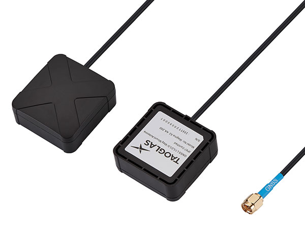
    The MagmaX2 AA.200 is designed for space and weight constrained applications, such as robotic lawnmowers, Quinlan said. Embedded antenna versions are also available.

    The AA.200 is a low-profile active multiband GNSS magnetic mount antenna for use across most major constellations including GPS (L1/L2/L5), GLONASS (G1/G2/G5), Galileo(E1/E5a/E5b) and BeiDou(B1/B2). It exhibits excellent gain and good radiation pattern stability leading to a reliable GPS fix in areas of weaker signal strength.

    Positional accuracy better than 60 cm (DRMS) is achievable, even without RTK corrections services. Accurate positioning down to 1.4 cm has been demonstrated with today’s multiband GNSS receivers and RTK services in the field.

    The Colosseum X XAHP.50 antenna. (Photo: Taoglas)
    The Colosseum X XAHP.50 antenna. (Photo: Taoglas)

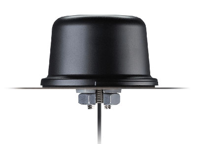
    The Colosseum X XAHP.50 is a geodetic-quality small-dome antenna suitable for a vehicle roof mount or pole mount. “Every element and aspect of the antenna performance has been optimized during the design of this antenna,” Quinlan said. “This includes many deep interlocking rf parameters for true accurate centimeter-level positioning, compared to legacy meter-only level systems. Phase center variation, group delay, multipath rejection, axial ratio over angle all become critical considerations and performance targets.”

    The XAHP.50 is engineered to operate with incredibly high precision capabilities on the full GNSS spectrum. Sub meter positional accuracy better than 55cm (DRMS) is achievable, even without the use of RTK correctional services. This allows the user to achieve higher location accuracy, as well as stability of position tracking in urban environments.

    The XAHP.50 has excellent performance across the full bandwidth of the antenna and its design has an even gain across the hemisphere giving excellent, broad axial ratio which in turn makes it resilient to multipath rejection and excellent phase centre stability. Accurate positioning down to 1.4 cm has been demonstrated with today’s multiband GNSS receivers and RTK services in the field.

    Antenna Development

    “In the design phase we simulate using electromagnetic analysis software and tweak every parameter,” Quinlan said. “Once we are happy with the results, we build our prototypes and test in scientifically controlled chamber and test environments validated by the European Space Agency, with repeatable GNSS signals.

    “We then move onto field testing in open-sky conditions and in non-line of sight environments to verify real-world performance with today’s state-of-the-art receiver systems from such leading companies as u-blox and Septentrio.

    What’s more, every single antenna coming off our production line goes through strict in-line sensitivity testing to ensure consistent validated performance. We take our commitment to quality and safety very seriously in the coming age of autonomous operation,” Quinlan concluded.

  • Spot on: Alliance to combine robots and GNSS tech for construction

    Spot on: Alliance to combine robots and GNSS tech for construction

    Spot, the robotic dog from Boston Dynamics, is equipped with the Trimble SPS986 smart antenna to collect data. (Photo: Trimble)
    Spot, the robotic dog from Boston Dynamics, is equipped with the Trimble SPS986 smart antenna to collect data. (Photo: Trimble)

    Trimble and Boston Dynamics plan to integrate a variety of data-collection technologies with the Spot (robot dog) platform for construction and other site applications.

    The jointly developed solution will combine the Spot robot’s autonomous mobility with Trimble’s data-collection sensors and field control software to enable automation of repetitive tasks such as site scans, surveying and progress monitoring, while taking advantage of the robot’s unique capabilities to navigate dynamic and potentially unsafe environments.

    The relationship gives Trimble exclusive rights sell and support the Spot robot with integrated scanning, total station and GNSS technologies for the construction market.

    The turnkey solution will streamline operation of the robot and provide quality control for missions, enabling construction project managers to easily get a clear picture of jobsite progress on an ongoing basis. Trimble technologies integrated with the robot will enable accurate, scalable and rapid data acquisition, while Trimble’s construction collaboration platforms provide a continuous flow of information between field and office.

    Mortenson, a Minneapolis builder, developer and engineering services provider, is one of the first customers to leverage the new technology combination. To eliminate jobsite waste and increase efficiency, the Mortenson team has been piloting Spot robots with the Trimble SPS986 GNSS solutions to autonomously navigate challenging exterior construction environments such as solar farms, continuously documenting site conditions.

    An automated and repeatable approach to field-data capture can provide Mortenson with real-time awareness of project status, helping to accelerate project delivery. Through Trimble’s Early Experience Program, contractors such as Mortenson have advanced access to this technology for the purposes of evaluating its suitability in actual construction projects.

    The Trimble SPS986 smart antenna. (Trimble: photo)
    The Trimble SPS986 smart antenna. (Trimble: photo)

    “Robots will play a crucial role in automated construction workflows and can augment the human workforce by handling dirty, dull and dangerous tasks,” said Martin Holmgren, general manager, Building Field Solutions at Trimble. “Our experience with early adopters like Mortenson gave us visibility into the transformative potential of an integrated solution that seamlessly marries a world-class robot with construction-specific sensors and workflows. We’re excited about this alliance and the potential to bring unprecedented improvements in safety, quality and productivity to our construction customers.”

    “We believe the combination of Trimble’s experience and industry leadership in construction technologies and Boston Dynamics’ Spot can transform the way the industry operates,” said Michael Perry, vice president of business development at Boston Dynamics. “The integrated solution will enable any jobsite leader to deploy Spot and Trimble technologies to get an accurate view of construction progress through real-time data collection. With a more comprehensive view of site activity, project managers can take proactive measures to ensure on-time, on-budget and safer project delivery.”

    The integrated solution is expected to be available by the second quarter of 2021 through Boston Dynamics, Trimble and select BuildingPoint and SITECH distribution partners in the U.S., Canada, the United Kingdom, the European Union, Australia, New Zealand and Japan.

    Through Trimble’s Early Experience Program, select customers will have the opportunity to preview development of the solution in advance of general availability.


  • GSA releases 3rd GNSS User Technology Report

    GSA releases 3rd GNSS User Technology Report

    Report cover GSA
    The full GNSS User Technology Report 2020 is available for download. (Cover: GSA)

    News from the European GNSS Agency

    The European GNSS Agency (GSA) has released its latest GNSS User Technology Report, providing a comprehensive analysis of GNSS trends and developments.

    With four GNSS available and more than 100 satellites in operation broadcasting multiple frequencies, the GNSS industry is shifting towards the wide adoption of multifrequency receivers across market segments to meet the diverging user needs of emerging applications.

    The report includes contributions from leading GNSS receiver, chipset manufacturers and service providers, and serves as a valuable tool to support planning and decision-making with regards to developing, purchasing and using GNSS technology.

    Published biennially since 2016, the User Technology Report has become a point of reference for the GNSS industry, research and policy-makers.

    Rapid Evolution

    ‘’The GNSS industry is evolving at a rapid pace and is shaped by the dynamics of emerging applications and user needs as well as the upgrade of existing and new GNSS and Satellite Based Augmentation Systems (SBAS),” said Rodrigo da Costa, GSA executive director. “The industry has understood the potential of Galileo’s unique features.”

    The third edition of the report begins with a chapter devoted to technology trends common to all segments: receiver design, position processing and signal processing. It also discusses protection measures against GNSS jamming and spoofing, such as authentication, including what 5G and other technologies and sensors can do, in combination with GNSS.

    With multi-constellation now being the norm, the industry is moving towards the wide adoption of multi-frequency receivers even for usually power- and cost-constrained consumer solutions. The Galileo E5 is becoming the preferred frequency with about 20% of all receiver models in the market already using it.

    The report is built around four macro segments defined on the basis of commonalities from a technology point of view:

    • high volume
    • safety- and liability-critical
    • high-accuracy
    • timing devices and solutions (a new-entry in this edition)

    Each chapter starts with the macrosegment characteristics and receiver capabilities, depicts the industry landscape and typical receiver form factor, it then delves into the key current and future drivers and trends, and finishes with the added value of the EGNSS, Galileo and EGNOS, for the macrosegment at stake.

    Space Data for Europe

    This year editor’s special “Space Data for Europe” sheds light on the role that Copernicus and Galileo play within the European Space Programme in the data management and use, now and in the future. It also provides a vision of major transformations underway within our society and our economy and the benefits expected from this digital transformation, paving the way towards the European Data Strategy and Green Deal.

    “Today, Galileo and EGNOS already provide increased capabilities which are being used across a broad range of applications, and are already igniting the next generation of location-based applications. In the future, new services — the Galileo High Accuracy Service (HAS), Galileo Open Service Navigation Message Authentication (OS-NMA) and Commercial Augmentation Service (CAS) — will raise the accuracy and reliability bar even higher, and dramatically enhance positioning, navigation and timing solutions for businesses and citizens.

    By bringing insight and understanding into the evolutions of GNSS technology, we are creating opportunities for innovation,” concluded da Costa.

    The full GNSS User Technology Report 2020 is available for download.

  • Russia adds to GLONASS constellation with latest launch

    Russia adds to GLONASS constellation with latest launch

    Russia launched a new-generation Glonass-K satellite, number 15, into orbit Oct. 25. Unlike its Glonass-M predecessors, Glonass-K satellites carry two types of navigation signals — frequency-separated and code-separated. The satellites emit additional code-division L2 navigation signals.

    In addition to their main functions, Glonass-K satellites will transmit information from the Cospas-Sarsat international search-and-rescue system. Additional Glonass-K satellites are in production at ISS Reshetnev, all with a domestic electronic component base.

    Russia’s Aerospace Forces (VKS) Space Forces launched the satellite aboard a Soyuz-2 rocket from the Plesetsk cosmodrome in the Arkhangelsk region. The launch of the carrier rocket and the maneuvering of the spacecraft into the orbit took place under normal operating conditions, according to Roscosmos.

    Two minutes after the launch, the ground-based automated control complex of the Titov Main Testing Space Center acquired the Soyuz-2. On schedule, the Glonass-K satellite was injected into the target orbit by the Fregat upper stage and taken over by the ground-based facilities of the VKS Space Forces.

    Photo: Roscosmos
    Photo: Roscosmos

    A stable telemetric connection has been established and maintained with spacecraft. The onboard systems of the Glonass-K spacecraft are operating normally.

    GLONASS consists of 28 spacecraft, with 24 active, two in reserve, and one Glonass-K undergoing flight tests. Another spacecraft is temporarily out for maintenance.

    Glonass-M satellites form the basis of the system’s orbital grouping. Replacing the orbital constellation with Glonass-K spacecraft will ensure the stable operation of the Russian navigation system and increase the accuracy of its navigation determinations up to tens of centimeters.

    According to Roscosmos, Glonass-K spacecraft are constructed in an unpressurized design, have a guaranteed period of active existence in orbit increased to 10 years, reduced energy consumption, and significantly lower weight.

    Photo: Roscosmos
    Photo: Roscosmos
  • First Galileo personal emergency beacon coming to 19 European countries

    First Galileo personal emergency beacon coming to 19 European countries

    The first Galileo Return Link Service Personal Location Beacon (PLB) developed under the H2020-funded Helios project will be released in December across 19 European countries. 

    News from the European GNSS Agency (GSA)

    Photo: Orolia
    Photo: Orolia

    In close collaboration with the European GNSS Agency and within framework of the H2020 HELIOS project, Orolia has been working to equip search-and-rescue beacons with the breakthrough Galileo Return Link Service.

    Declared operational in January, the Galileo Return Link Service is a unique feature of Galileo, allowing people in distress to receive an automatic acknowledgement that their signal has been received and their location is known.

    How It Works

    The FastFind ReturnLink PLB transmits the user’s unique ID and GNSS location via the global network of Cospas-Sarsat search-and-rescue satellites. When a person in distress activates the emergency beacon, the Galileo satellites capture the signal and transmit it to a set of ground-segment facilities — the Galileo Return Link Service Provider (RLSP) based in Toulouse, France.

    Once the location of the person in distress is determined, an automatic message is sent through the Galileo satellites, confirming to the user that their position has been detected and the information has been routed to the relevant government authorities. With the FastFind ReturnLink PLB, the person in distress — on land or at sea — will see a blue light blinking on their beacon 10-15 minutes after confirmation that the distress signal and location has been detected.

    ”At the GSA, our objective is to ensure that EU Space investments and our work on Galileo services are bringing added value to citizens,” said Rodrigo da Costa, GSA executive director.  “With the first search-and-rescue beacon worldwide deployed thanks to the H2020 project Helios, we can proudly state that our actions made a difference for innovation but also for the citizens. The ones who need to use this Personal Location Beacon will be reassured by the Return Link Service.”

    Cospas-Sarsat rescue beacon activated. Its signals are picked up by satellites in orbit, including Galileo. (Photo: GSA)
    Cospas-Sarsat rescue beacon activated. Its signals are picked up by satellites in orbit, including Galileo. (Photo: GSA)

    Galileo a SAR Game Changer

    Galileo’s immediate impact on search and rescue (SAR) has been the addition of 26 new satellites, allowing for greater global coverage and faster detection of the 406-MHz distress frequency. Coupled with Galileo’s robust signal, SAR beacons deliver greater positioning accuracy.

    Galileo’s development is part of the European Union’s preparations for upgrading the international distress beacon locating organisation Cospas-Sarsat’s Search and Rescue (SAR) Ecosystem under the MEOSAR program, which requires new Earth-based antenna and a network of 72 GNSS satellites, combining GPS, the EU Galileo and the Russian Glonass systems. The Return Link Service is a unique feature provided by Galileo within its contribution to Cospas-Sarsat.

    Survival Booster

    By sending a confirmation to the user that the distress signal from the beacon has been localised by the Cospas-Sarsat system and the information relayed to the relevant Search and Rescue l authorities, the Return Link Service provides confidence and reassurance to the people in distress that help is on the way.

    “The Search and Rescue community has long known the survival impact of dealing with a distress situation on your own, either as a solo adventurer or as a group that feels isolated due to the lack of communication with the outside world,” said Chris Loizou, vice president of Maritime at Orolia. “The Return Link reassurance signal will reduce the chances of rash decisions taken by those who feel they have nothing to lose, such as leaving the site of an accident or attempting to swim to safety. The psychological impact of knowing that help is on the way cannot be underestimated, and this PLB will provide invaluable peace of mind for those in distress.”

    The Galileo Return Link Service increases survival rates by giving an important psychological boost to people in distress. It is estimated by Cospas-Sarsat that the international SAR system, with the contribution of the Galileo Search and Rescue service, saves more than 2,000 lives a year.

    Countries Included

    The beacons will be sold in the following countries.

    • Croatia
    • Cyprus
    • Denmark
    • Faroe Islands (DK)
    • France
    • Germany
    • Greece
    • Greenland (DK)
    • Iceland
    • Ireland
    • Israel
    • Italy
    • Latvia
    • Liechtenstein
    • Norway
    • Sweden
    • Switzerland
    • United Kingdom

    Eventually, the RLS-enabled beacons will be available in most countries in the world.

  • GNSS + Wi-Fi evaluation kit offered for IoT by Semtech, Actility

    GNSS + Wi-Fi evaluation kit offered for IoT by Semtech, Actility

    Photo: Actility
    Photo: Actility

    Actility and Semtech are offering the LR1110 LoRa Edge Evaluation Kit with a tracking device based on Semtech’s LR1110 chipset and Actility’s LoRaWAN network management expertise.

    The solution delivers ultra-low power meter-accurate positioning both indoors and outdoors.

    The kit allows solution providers and integrators to quickly evaluate this new technology and to experience how it reduces the cost and complexity of building a solution for locating and monitoring internet-0f-things (IoT) assets.

    The LR1110 chipset, integrated to LoRa Edge, uses assisted GNSS (AGNSS) and Wi-Fi AP scanning, alongside standard LoRaWAN communications. It is bundled with Actility’s LoRaWAN network server (the ThingPark platform) and with the Tago.io application server.

    ThingPark Enterprise delivers the data to Tago.io through a predefined interface. Tago.ai provides a mechanism for customers to route received location data to an actionable dashboard with the map location history, the data traffic history and other data.

    The chipset has already been adapted by multiple companies such as Abeeway for its newest geolocation module.

    Low-power geolocation

    Semtech’s LR1110 is the first product in its new LoRa Edge platform — a highly versatile, low power, software-defined LoRa-based platform designed to enable a wide portfolio of applications for indoor and outdoor asset management.

    Modular and configurable, the LR1110 can transition between outdoor and indoor activity automatically, using GPS satellite tracking for outdoor applications and Wi-Fi passive scanning for tracking indoor assets. It replaces the need to build different trackers for indoor or outdoor use or trackers that combine multiple location methods with a single chipset, reducing complexity and cost.

    It contains the ultra-low power capabilities of a LoRa transceiver. This means that it can communicate over LoRaWAN and it can be used to acquire position coordinates either through GNSS or Wi-Fi signals. Instead of changing the batteries on asset trackers every three to six months with conventional Wi-Fi technology, LoRa Edge delivers low power consumption allowing battery lifetimes up to three years.

    A crypto engine allows LoRaWAN keys to be stored inside the device for secure joining and communication. Modules can be securely activated from Semtech’s LoRa Cloud Device Activation Service.

  • Hexagon Geospatial updates platform for location intelligence

    Hexagon Geospatial updates platform for location intelligence

    Luciad 2020.1 provides capabilities with panoramic imagery. (Screenshot: Hexagon Geospatial)
    Luciad 2020.1 provides capabilities with panoramic imagery. (Screenshot: Hexagon Geospatial)

    Luciad 2020.1 features dynamic panoramic imagery capabilities and immersive 3D imagery

    Hexagon’s Geospatial division has launched Luciad 2020.1, a significant update to its platform for building advanced location intelligence and real-time, situational awareness applications.

    Luciad 2020.1 delivers immersive 3D experiences with 360-degree panoramic imagery support that can be combined with other 3D data layers for geospatial applications. The latest release also features additional styling for 3D meshes and 3D data integration capabilities.

    Visualization and Analysis

    Hexagon’s Luciad portfolio allows developers to create powerful, high-performance applications that leverage data from any source for visualization and analysis in 2D and 3D. Combining static, dynamic and real-time data, including moving tracks, Luciad-powered applications support defense, aviation, infrastructure and other critical sectors.

    For the 2020.1 release of LuciadRIA, which is used for building browser-based solutions, Hexagon has added 360-degree panoramic imagery capabilities that can be combined with other 3D data layers to provide complete imagery coverage and detailed information about a location. Panoramic imagery puts users in control of what they want to look at within an image. The panoramic 3D experience is powered by a new streaming imagery data service in LuciadFusion, Hexagon’s OGC-compliant server solution.

    “With the addition of panoramic imagery capabilities and other 3D data enhancements, Luciad 2020.1 puts local governments, transportation departments, utility companies and others in control of what they can observe and analyze within a particular scene,” said Mladen Stojic, president of Hexagon’s Geospatial division. “With these capabilities, organizations can remotely monitor their assets and infrastructure, significantly reduce manual inspection processes and fully leverage location intelligence across the enterprise.”

    More New Features

    The release contains other new features and improvements requested by customers, including:

    • military grid coordinate transformations
    • non-georeferenced WebGL-based views
    • improved imagery sampling
    • additional format support and upgrades.

    For defense customers, the Luciad 2020.1 release consolidates its military symbology support across all Luciad platforms and programming languages.

  • Topcon Agriculture offers enhanced in-cab displays

    Topcon Agriculture offers enhanced in-cab displays

    Photo: Topcon
    Photo: Topcon

    Topcon Agriculture has released new in-cab displays — XD and XD+ touchscreen consoles — with an upgraded user interface experience, Horizon 5.

    With Topcon Agriculture Platform (TAP) integration, the consoles are designed to provide farmers with full-feature customization to optimize their investment by paying only for capabilities they need.

    “As a farmer’s needs grow, often times they’ve had to use multiple single-function consoles. In recent years, Topcon has offered the X family of consoles designed with all-in-one capability to resolve this issue, reducing clutter, improving setup, updates, support, and reducing overall hardware costs,” said Brian Sorbe, vice president of global production solutions. “Now with the additions to the series, Topcon is further simplifying cab control and it’s a modular approach with future needs in mind for each unique farming operation.”

    Farmers can immediately take advantage of off-the-shelf features such as basic guidance, task management, universal ISO-UT compatibility, and TAP Fields to manage farm data. Additional features are unlockable for use with the full range of Topcon sensors and application control technology.

    “TAP is a digital farm management system and it’s a way for a farmer to organize, visualize and make decisions and it begins with the touch of the console in the cab, and now with the new user interface and digital system all integrated, it will be simpler and easier to setup and get to work,” Sorbe said.

    The new consoles are designed to be ready for any application such as soil preparation, seeding, crop care, harvest, weighing and data services.

    The consoles are available in 7-inch and 12.1-inch screens, including new day and night modes.

  • Septentrio open-source software and hardware aimed at autonomous applications

    Septentrio open-source software and hardware aimed at autonomous applications

    Septentrio, a leader in high-precision GNSS positioning solutions, is offering two open-source resources for its GPS/GNSS module receivers.

    • The first, ROSaic, is a Robot Operating System (ROS) driver for the mosaic-X5 module as well as other Septentrio GNSS receivers.
    • The second project, mosaicHAT, is an open source hardware reference design combining mosaic-X5 with a Raspberry Pi single-board computer.

    Both projects facilitate integration of centimeter-level reliable positioning into robotic and other machine automation applications.

    Photo: Septentrio
    Photo: Septentrio

    ROSaic driver operates on ROS, a widely used programming environment within the industry as well as academics, commonly used for integrating robot technology and developing advanced robotics and autonomous systems. ROS allows data from numerous sensors to be combined allowing high levels of autonomy.

    The mosaicHAT project facilitates accurate and reliable GNSS positioning for robotics and automation on a hardware level. Numerous engineers today use Raspberry Pi for prototyping and initial integrations. The mosaicHAT board is an easy way for integrators to get started with Septentrio’s mosaic-X5 GNSS module.

    By plugging mosaicHAT into a compatible Raspberry Pi, users have access to high-accuracy positioning with a high update rate, ideal for machine navigation and control, the company said. The small 56×65 mm board exposes basic interfaces such as USB, serial and general-purpose communication pins. The reference design, footprint and documentation are available for easy board printing or further customization.

    “We are excited about both the ROSaic driver and the mosaicHAT being part of the GitHub community and we highly appreciate the initial authors work as well as the future contributors,” said Gustavo Lopez, market access manager at Septentrio. “Both projects are available as open source, thus empowering the community to easily fit autonomous or robotic systems with highly accurate and reliable GNSS positioning technology.”

    The ROSaic driver is available on the ROS wiki page and on the Septentrio GitHub repository while the mosaicHAT can be found here.

    ROS is a trademark of Open Robotics. Raspberry Pi is a trademark of the Raspberry Pi organization.

  • Aceinna joins ST Partner Program for precise positioning

    Aceinna joins ST Partner Program for precise positioning

    Photo: gorodenkoff/iStock/Getty Images Plus/Getty Images
    Photo: gorodenkoff/iStock/Getty Images Plus/Getty Images

    Partnership combines Aceinna’s integrated precise positioning and advanced guidance expertise with ST’s products, technologies and solutions.

    Innovative sensing technology company Aceinna Inc. has joined the STMicroelectronics Partner Program to make its inertial measurement unit (IMU) and real-time kinematic (RTK) precise positioning solutions available to engineers and developers working on next-generation solutions that safely and accurately position autonomous automobiles, trucks, robots and delivery vehicles.

    Aceinna is also participating in the Virtual ST Developers Conference on Oct. 20 and Oct. 21 from 8:30 a.m. to 4 p.m. ET, which discusses precise positioning for autonomous vehicles. Register here.

    “By leveraging ST technology, Aceinna is providing customers with vertically integrated performance sensing platforms,” said Yang Zhao, CEO of Aceinna. “These system-level solutions help customers greatly accelerate development time as well to reduce the time to market for new autonomous vehicle technologies.”

    “The ST Partner Program helps customers’ design teams access extra skills and resources to aid engineering development and shorten time-to-market for new products,” said Alessandro Maloberti, partner ecosystem director, STMicroelectronics. “By selecting, qualifying, and certifying our program partners like Acennia Inc., we are taking yet another major step in helping customers accelerate design and development, and ship to market the most robust and efficient products and services.”

    STMicroelectronics, a global semiconductor leader serving customers across the spectrum of electronics applications, created the ST Partner Program to speed customer development efforts by identifying and highlighting to them companies with complementary products and services. The program’s certification process assures that all partners are periodically vetted for quality and competence.

  • Optical navigation enables sample collection from asteroid

    Optical navigation enables sample collection from asteroid

    NASA took on a Herculean precision positioning task that culminated Oct. 20 with a spacecraft sampling the surface of an asteroid from a 5-meter area — a NASA first.

    The OSIRIS-REx spacecraft, launched on Sept. 8, 2016, spent two years mapping the Bennu asteroid to determine the best site for removing the sample. Bennu was selected because of its near-Earth position (a mere 200 million miles away) as well as its age. It’s considered a primitive remnant from the formation of the solar system. It’s the smallest body a spacecraft has ever orbited.

    The infrared spectrometer on OSIRIS-REx confirmed Bennu was sandy, but photos showed it to be an unrelenting rockscape dominated by boulders. Because of this difficult terrain, the planned sample site was reduced from 50 meters to 5 meters, an area smaller than a parking lot. “This required us to rethink how to navigate to the surface and come up with new ideas,” said Coralie Adam, TAG navigation manager for KinetX Aerospace. TAG stands for Touch-And-Go, the sample-collecting procedure.

    The mapping method changed from using a lidar-based technique to an optical-based technique. “When we saw what Bennu looked like, we realized we had to switch to a vision-based approach, and that’s the NFT system,” explained Mike Moreau, Osiris Rex deputy project manager, Goddard Space Flight Center.

    The Natural Feature Tracking (NFT) was added to the mission at the critical design review stage. NFT is an onboard optical navigation system that compares observed images to a set of asteroid terrain models rendered in real-time from a catalog stored in the flight computer’s memory. Onboard knowledge of the spacecraft state is then updated by a Kalman filter using the measured residuals between the rendered reference images and the actual observed images. (Read a technical paper on NFT.)

    The asteroid terrain models used by NFT are built from a shape model generated from observations collected during earlier phases of the mission and include both terrain shape and albedo information about the asteroid surface.

    “The KinetX navigation team spent last two years to learning how to navigate around Bennu using optical navigation techniques,” Adam said. She explained that every few minutes, a navigation camera takes an image of the features below and sends it to the NFT. The system identifies features in the image and sends a signal back to Earth.” The KinetX team worked with the Lockheed Martin team to map the surface of Bennu to a resolution of 2 centimeters per pixel.

    With this observational data, the team created a hazard map. With position uncertainty down to half a meter, a sample site dubbed Nightingale was successfully contacted, and 2 ounces of regolith collected.

    The team included mission managers from the University of Arizona, Lockheed Martin, and NASA’s Goddard Space Flight Center.

    The Origins, Spectral Interpretation, Resource Identification, Security-Regolith Explorer (Osiris-REx) spacecraft
    is scheduled to depart Bennu in 2021, and to deliver the collected sample to Earth on Sep. 24, 2023. It will be the first U.S. mission to carry samples from an asteroid back to Earth, and the largest sample returned since the Apollo missions.

    Artist's concept of the OSIRIS-REx spacecraft orbiting the Bennu asteroid. (Image: NASA)
    Artist’s concept of the OSIRIS-REx spacecraft orbiting the Bennu asteroid. (Image: NASA)
  • Geotab Keyless helps car-sharing fleets pool assets

    Geotab Keyless helps car-sharing fleets pool assets

    Photo: MStudioImages/E+/Getty Images
    Photo: MStudioImages/E+/Getty Images

    Connected transportation company Geotab has unveiled Geotab Keyless, a platform solution that integrates a secured digital key function with a comprehensive and data-driven fleet management product. Announced at the company’s third annual Geotab Mobility Connect conference, this combined solution is enabling a new class of car sharing by allowing public, corporate, leasing and government fleets to better analyze, pool, utilize and reduce their assets.

    “We are proud to be the first fully-featured telematics provider bringing a unique data-driven, keyless solution to the burgeoning car sharing market,” said Christopher Mendes, VP, Electric Vehicles, Geotab. “Keyless vehicle access is critical not only for fleets seeking to improve cost and operational structures but also consumers, who are moving away from vehicle ownership and expecting an easier, more convenient driving experience.”

    Car sharing on the rise

    According to a 2019 research report from Berg Insights, worldwide car-sharing membership topped 50.4 million in 2018, with the report citing frontrunners including Germany, Italy, USA and South Korea. As the Latin American market continues to rapidly grow, numbers are forecast to hit approximately 227 million by the end of 2023.

    Berg Insights also notes that several car makers, leasing companies and car rental companies are introducing car sharing solutions for corporate customers, with a goal to reduce mobility costs for enterprises by decreasing fleet capacity and the need for taxis and rental cars, while enabling self-booking and keyless access. Telematics and smartphones will play a pivotal role.

    “Geotab Keyless is designed to enhance car sharing across every segment, including in-car delivery services in the future” added Mendes. “Keyless is particularly advantageous for electric vehicle (EV) car sharing fleets, as the solution can reliably manage vehicles’ state of charge (SOC), charging status and range remaining —a capability no other keyless hardware competitor possesses.”

    Scalable platform

    A simple-to-install, scalable platform solution, Geotab Keyless supports any make, model and year of vehicle that has a key fob, and provides access to the most extensive telematics data on the market including asset accounting, suitability analysis for corporate car sharing, vehicle management automation and remote vehicle management.

    Fleet customers can pair their Geotab telematics solution with a vehicle reservation system software partner of their choice in order to best meet their individual business needs.

    Global software partners for Geotab Keyless include Wunder Mobility, Ridecell, fleetster, Eccocar and Moove Connected Mobility. Or fleet customers can create their own reservation software using Geotab’s Keyless APIs.

    How Geotab Keyless works

    Once a key fob is embedded into the hardware, drivers open their third-party software app on their phone (which is integrated with their MyGeotab platform), locate the OEM button on the screen and use the features to lock, unlock and start the vehicle.

    In addition to phone apps, the keyless functionality can be enabled by NFC tags and directly over the cellular connection. Over time, the solution will expand to include other applications and third-party digital key hardware solutions, as well as OEM telematics’ APIs.

    “In an increasingly dynamic world, on-demand free-floating shared mobility options are enabling new and innovative business opportunities for government and commercial fleets,” said Jean Pilon-Bignell, VP of Business Development, Government and Smart Cities. “By integrating this capability with a world-class telematics platform, fleets can have confidence in the fact that their shared mobility investments are backed by real data and analytics.”

    Data-driven insight

    Currently equipping more than 2.1 million vehicles with its telematics technology, Geotab provides data-driven insights to over 40,000 customers worldwide and enables users to customize their solution through a suite of more than 150 hardware add-ons, software add-ins and applications available on the Geotab Marketplace.

    As a result, the company processes more than 40 billion data points each day from Geotab-connected vehicles around the world. With active devices present in more than 130 countries, Geotab’s solutions are sold through its global network of Authorized Geotab Resellers.