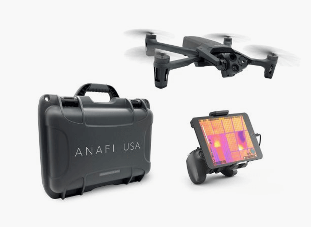
Skyward, a Verizon company, and Parrot, a European drone group, are partnering to deliver Parrot ANAFI drones along with Skyward drone program management, flight-log sync and training to U.S. enterprises.
In particular, the new speaks to a widespread need among U.S. companies and public agencies for a secure, high-end drone manufactured domestically. Sold by Skyward, the ANAFI USA and training package gives enterprises a one-stop shop for building and scaling a drone program with aircraft, policies and procedures, training, and automatic flight log sync to the software platform to manage it all.
“ANAFI USA was designed to meet the needs of the most demanding professional users while offering enterprise data security and privacy,” said Henri Seydoux, founder and CEO of Parrot. “Now, combined with Skyward’s enterprise drone solutions covering training and integrated software platforms, professional users have access to one of the most comprehensive suites of hardware, software and services.”
In addition to its security benefits, Parrot’s ANAFI USA features 32x zoom 4K HDR video and thermal imaging capabilities. It is portable, weather-resistant and ready to launch in seconds.
“Now enterprises can maximize their investment in the ANAFI USA by pairing it with Skyward’s in-person and online operator training and robust management platform,” said Mariah Scott, president of Skyward, A Verizon company. “This is just the beginning of a strong partnership with Parrot. Look for continued feature integration and connectivity offerings as we move the industry forward together.”
Skyward users can automatically log flights from the Parrot FreeFlight 6 piloting application for the ANAFI, ANAFI Thermal and ANAFI USA drones with additional integration features coming soon to maximize the value of both platforms.
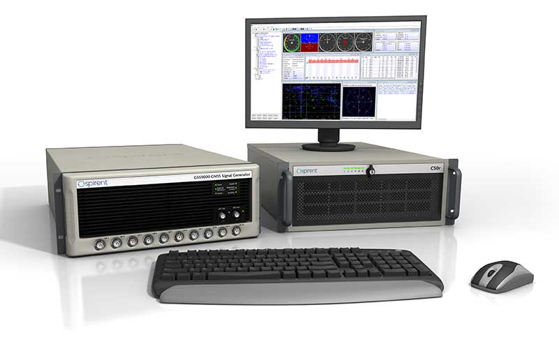
GNSS simulator company Spirent Federal Systems will soon release SimMNSA 2.0. The release adds advanced scenario controls that enable full recreation of government test vectors while retaining the simple key and fly option of the initial release.
Spirent Federal developed software that supports M-code signals using the Modernized Navstar Security Algorithm (MNSA). SimMNSA 1.0 was released in 2018 and is now used in laboratories throughout the country with receivers from all M-code manufacturers.
“SimMNSA is the first MNSA-based M-code signal simulation to receive government security approval,” said Ellen Hall, President and CEO. “We pride ourselves in being leaders in innovation and we will continue to push ourselves to meet the growing needs of our customers.”
Release 2.0 of Spirent Federal’s SimMNSA is scheduled for later this year. It will be available to authorized users of the GSS9000 Series, at no additional cost to current SimMNSA users under maintenance contracts.
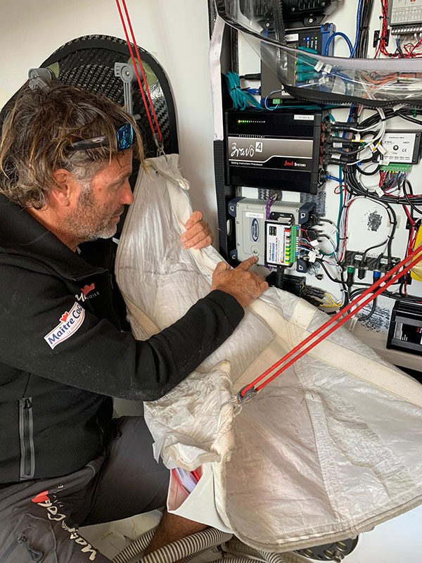
The Spectra Geospatial SP90m GNSS receiver will guide the racing yacht Maître CoQ for the 2020 Vendée Globe, single-handed, non-stop around-the-world yacht race. The Vendée Globe is an extreme endurance test for both sailor and boat and widely considered the ultimate challenge in ocean racing. The race starts Nov. 8 and is expected to finish in late January or early February.
The SP90m will provide the skipper of the Maître CoQ, Yannick Bestaven, with precise position and boat heading information. The SP90m information is integrated to a separate attitude information source, and the entire package of the position, heading and attitude is sent to the boat’s autopilot.
Photo: Spectra Geospatial
Bestaven, responding to the changing sea and wind conditions, strategically adjusts the autopilot to keep the boat moving at top speed to the desired destination as he changes and trims sails and trims foils to achieve maximum sailing efficiency.
The Maître CoQ is an advanced design mono-hull foiling sailing yacht in the category of IMOCA (International Monohull Offshore Class Association) which have a fixed length of 18.28 meters (60 feet), Antoine Connan, head of engineering for the Maître CoQ racing team, selected the SP90m.
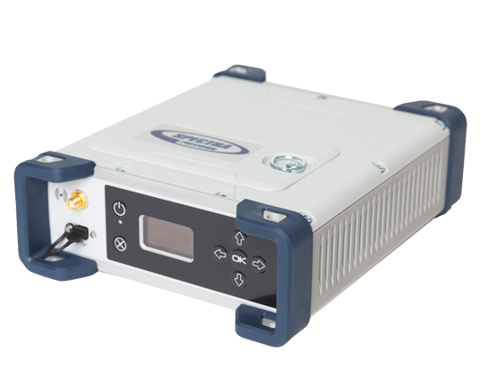
The hostile environment and requirements for precise position information at sea far from land made the selection of the SP90m an important technical choice. It always delivers an accurate position and precise heading with no GNSS corrections.
Commenting on the performance of the SP90m in the recent July 2020 2,800-mile qualifying race, the Vendée- Arctique-Les Sables D’Olonne, Connan reports, “We are already very happy with its installation on board.”
The SP90m is a rugged design for marine environments. With 480-channel tracking and dual GNSS antenna inputs, the SP90m is an integrated onboard rover receiver offering minimal size and low power consumption.
When the Maître CoQ technical team, based in La Rochelle, decided they needed to upgrade the boat’s navigation system, they contacted Cadden, a specialist in supplying advanced electronic precision measurement sensors. In addition to the requirement for delivering fast, precise position and heading data, the new sensor had to be lightweight, small, require little power, be easy to integrate, and flawlessly withstand a hostile saltwater environment. Cadden’s analysis concluded the Spectra Geospatial SP90m fit the spec perfectly.
“We are thrilled that the Maître CoQ racing team selected the Spectra Geospatial SP90m,” said Olivier Casabianca, vice president Spectra Geospatial. “It’s one more confirmation that Spectra Geospatial provides truly the highest quality rugged and precise GNSS receivers.“
About the Vendée Globe 2020. Held every four years, the Vendée Globe is a single-handed (solo) non-stop yacht race around the world without assistance. It starts and finishes in Les Sables-d’Olonne in the Département of Vendée in France. The course is a circumnavigation from Les Sables- d’Olonne, that heads south in the Atlantic Ocean to the Cape of Good Hope, then east in the Southern Ocean clockwise around Antarctica, keeping Australia’s Cape Leeuwin and South America’s Cape Horn to port (to the left); and then back north in the Atlantic returning to finish in Les Sables-d’Olonne.
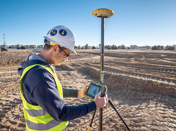
Trimble continues to increase its footprint to deliver high-accuracy positioning correction services
Photo: Trimble
Trimble has acquired MidStates VRS, a network previously owned by Butler Machinery and Frontier Precision. The addition of the network, in North and South Dakota, increases the footprint of Trimble’s VRS Now GNSS corrections service to cover more than one million square miles in North America. Financial terms were not disclosed.
As part of an ongoing expansion strategy, the new coverage for the VRS Now subscription service helps users in more places achieve high-accuracy positioning to increase productivity, reduce operational costs and improve safety.
The correction service is designed for professionals in agriculture, geospatial and construction as well as emerging autonomous applications including lane-keeping for passenger vehicles, vehicle-to-everything (V2X) position identification and unmanned aerial system guidance.
Adding 105,000 square miles of coverage, the acquisition expands Trimble’s VRS Now network to be one of the largest in North America — over one million square miles, contributing to Trimble’s shift toward a software, services and subscription business emphasis.
When using the Trimble VRS Now service, land and construction surveyors, GIS professionals and farmers — with a Trimble or third-party commercial GNSS receiver — can leverage instant high-accuracy corrections delivered via cellular network to improve productivity.
Enabling users to work without a GNSS base station, the service is cost-effective and simple to use. It is ideal for a variety of applications that require sub-inch level accuracy and is an important component of the connected construction site and connected farm workflows.
“The MidStates VRS network covers significant farmland, oil fields and rapidly developing urban areas, providing farmers and surveyors in the region with the real-time GNSS correction services they need to improve their day-to-day work,” said Patricia Boothe, senior vice president of Trimble’s Autonomy Sector. “The purchase of the MidStates network demonstrates Trimble’s ongoing commitment to provide a wide range of correction services for autonomous solutions — delivering unmatched access to fast, reliable and highly accurate positioning in more areas than ever before.”
Trimble networks are supported by a global network operations team made up of GNSS system engineers, geodesy experts and IT professionals. The team monitors the networks 24/7 from operation centers located on three continents, providing consistent and reliable service uptime and performance integrity.
Trimble VRS Now. The correction service offers instant access to centimeter-level positioning tailored to the users’ geographic location; the service is always on wherever and whenever needed within the network coverage area. With no base station or setup required, it is cost-effective, efficient and simple to use.
VRS provides positioning professionals with instant access to real-time kinematic (RTK) and post-processing (PP) corrections utilizing a network of permanent (fixed) continuously operating reference stations (CORS).
Trimble-owned VRS networks are accessible now in areas throughout the U.S. and Canada as well as Eastern Australia and Tasmania, France, Belgium, the Czech Republic, Estonia, Germany, Great Britain, Ireland, Luxembourg, the Netherlands, Sweden and New Zealand.
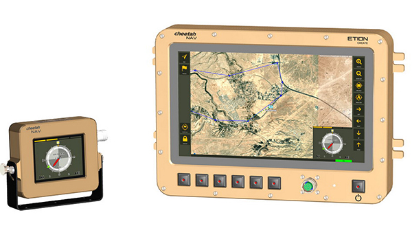
A new military vehicle navigation system designed and developed by South Africa-based Etion Create is ready for the local and export markets.
Designed for harsh environments and battlefield conditions, the CheetahNAV provides outstanding situational awareness, according to Etion Create. The crew of a light military vehicle can count on highly accurate position information, irrespective of whether they are denied satellite navigation. This is achieved through an advanced inertial measurement system (IMS), comprising several aids, including a gyro-compensated compass and an advanced Kalman filter-based algorithm.
“We are confident that the system provides dead-reckoning horizontal position accuracy of 0.2% of distance travelled in a GNSS denied situation,” said Jan Hurter, senior product manager. “This translates, by way of example, to accuracy of just 200 metres over a distance of 100 kilometers.”
The CheetahNAV can integrate with any number of different inertial navigation systems (INS) and can be aligned with any of the satellite navigation constellations. Combined with GNSS and compass information, the system enables dead-reckoning and accurate positioning of the vehicle in tactical situations. The tactical grade integral inertial measurement unit (IMU) ensures jamming-free operation.
Some of the guidance cues the system provides to the crew during tactical maneuvers include the vehicle’s current position, true heading and desired heading towards the next waypoint, current speed and desired speed to reach the next waypoint or destination on time, and the next waypoint or destination. It also shows the pitch and roll attitude of the vehicle and the track it has travelled.
This data is displayed on a sunlight-readable touch-screen enabled moving map display unit measuring 11.6-inch diagonal, in 16:9 TFT format, with a 1920×1080 resolution. Etion Create is also offering a slave unit for the vehicle driver, as the main display might be positioned elsewhere in a space constrained vehicle. This slave unit, measuring 3.5-inch diagonal TFT, displays information that is specifically required by the driver.
Significant benefits of the CheetahNAV system include ruggedness for extreme battlefield conditions and 28V or 12V DC operation in line with military standards. Moreover, it boasts a high operational reliability.
“It is important to note that Etion Create, as original design manufacturer, is focusing the CheetahNAV on the export market, including the possibility of technology transfer for indigenous manufacturing,” said Hurter. “Besides we offer a multi-language option, which is certainly a key advantage in multinational operations that are almost the norm nowadays.”
The CheetahNAV is non-ITAR controlled, which is the preference of most land forces around the world today to meet their battlefield management requirements.
Having utilized the building blocks of previously developed military off-the-shelf technologies, Etion Create considers the system to be at a high TRL (technology readiness level), and thus available for the export market.
Previously called Parsec, Etion Create is a South African original design manufacturer (ODM) with a long-standing international reach and a professional portfolio of technology offerings and experience across a wide range of business sectors, including defence and aerospace, information security, and mining and industrial sectors.
The global construction robot market was valued at USD 231.5 million in 2018 and is expected to reach USD 464.8 million by 2026, growing at a compound annual growth rate (CAGR) of 9.5% during the forecast period, according to an InForGrowth market report.
The construction industry is one of the least automated industries that features manual-intensive labor as a primary source of productivity. However, with the advancement in technology, the construction industry is utilizing robots to excel at repetitive tasks in a controlled environment.
Construction robots have a major impact on the construction industry. The construction industry is looking to automate more and more tasks for the sake of productivity and efficiency, which in turn is increasing the demand for construction robots.
The use of robots has grown considerably with increasing speed, efficiency, safety and profit concerns. Construction robots have provided a transformative experience for the entire industry and have helped in replacing or improving existing processes, making them more proficient as well as more precise.
Companies are deploying these new commercially viable robots in various applications such as 3D printing of large structures, disaster relief situations, construction of tall structures, and for assisting workers performing laborious tasks. These robots have helped in automating laborious and dangerous tasks to keep laborers away from hazardous activities and enable them to focus on more productive work.
3D printing. Moreover, the evolution of 3D printing in the construction industry is expected to create opportunities in the market. This will further enhance the market size of the global construction robot market. An increase in research and development activities to minimize the cost of robots will also enhance the market size over the forecast period.
However, the high cost associated with the deployment of robotic solutions is expected to hamper the growth of the global construction robot market during the forecast period.
Key findings. Based on the product type, the traditional robot segment accounted for the largest market size in the global construction robot market in 2018.
Based on automation, the semi-autonomous robot segment accounted for the largest market size in the global construction robot market in 2018.
Based on function, the demolition robot segment held the largest share in the global market in 2018.
Based on applications, the public infrastructure segment is expected to dominate the market during the forecast period. Europe accounted for nearly 30% share of the global market in 2018.
Recent industry news. In September 2019, Built Robotics closed a US$ 33 million Series B funding round, led by Next47, the global venture fund backed by Siemens, for autonomous construction equipment.
In August 2019, John Sisk & Son used MULE at Sisk’s residential Wembley Park E05 site in London to reduce fatigue and injuries among workers and increase productivity.
In June 2019, Boston Dynamics launched an inspection robot named SPOT, which is mounted with 3D cameras to inspect and map construction sites and identify hazards and work progress.
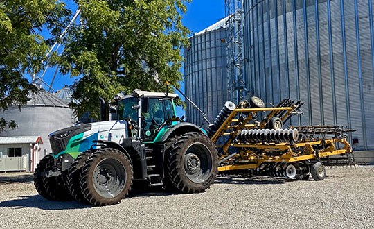
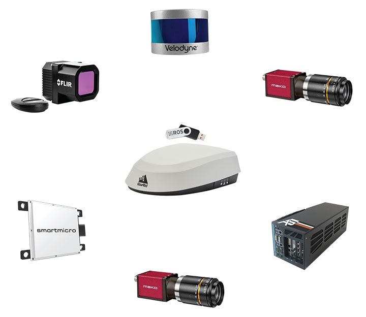
Hexagon’s Autonomy and Positioning division has launched its first autonomy positioning and sensing kits for the agriculture market and validated these solutions in its new autonomous research and development tractor.
Through collaboration between NovAtel and AutonomouStuff, both part of Hexagon, the autonomous positioning and sensing kits were developed as part of Hexagon’s Smart Autonomous Mobility solutions portfolio launched at CES in early 2020. NovAtel and AutonomouStuff created the solutions with agriculture machinery OEMs and robotic machinery manufacturers in mind.
As a demonstrator vehicle for Smart Autonomous Mobility, the autonomous tractor features object detection and classification, simultaneous relative localization and mapping, absolute positioning through GNSS technology, and localization sensor fusing. Built to illustrate the viability of new positioning and sensing kits, the tractor incorporates safety-critical learnings with situational and environmental awareness, and manual remote control when needed. This platform validates how these solutions and capabilities accelerate autonomous development.
Hexagon’s autonomous research and development tractor validated the new kit. (Photo: Hexagon)
The positioning and sensing kits are optimized for autonomous agriculture applications, including products like the Smart7 antenna and autonomous robotic capabilities through the NovAtel OEM7 driver powered by the Robot Operating System (ROS). The kits also feature TerraStar GNSS Correction Services, ALIGN heading and relative positioning firmware, and SPAN GNSS+INS technology. Though designed for agriculture, the kits integrate seamlessly into other off-road autonomy applications.
“These positioning and sensing kits provide developers with technology bringing assured positioning to autonomy in agriculture,” explained Michael Martinez, agriculture segment manager at Hexagon | NovAtel. “Robotic-machinery manufacturers or those experienced in autonomy may be unfamiliar with the unique challenges facing agriculture applications. Conversely, those experienced with agriculture may not have the expertise to integrate positioning and sensing products within autonomous solutions. We can help in both cases through these positioning and sensor kits, as demonstrated by our autonomous tractor.”
The new autonomous positioning and sensing kit. (Photo: Hexagon)
“We’re excited to use this tractor as a platform to validate the human identification, obstacle detection and enhanced environmental awareness that our sensing kits add to our assured positioning solutions in agriculture,” said John Buszek, VP of products and services at Hexagon | AutonomouStuff. “The sensing and positioning technologies we’ve integrated on this demonstration platform showcase the Smart Autonomous Mobility portfolio, which enables and accelerates the development of autonomy in agriculture applications from prototyping to production.”
For more than 30 years, NovAtel has delivered GNSS positioning solutions as a trusted provider for top precision agriculture companies. Combined with AutonomouStuff’s decade of expertise in autonomy and sensor fusion, they significantly reduce the barrier of entry into autonomy to accelerate the time to market for autonomous solutions in agriculture, construction, mining and other off-road applications.
Learn more about their agriculture autonomy capabilities by taking a virtual tractor tour via their 3D interactive app or online at novatel.com/ag-autonomy.
GMV Innovating Solutions Limited — the U.K. aerospace company belonging to the Spanish technology multinational GMV — has signed a merger agreement with Nottingham Scientific Limited (NSL).
GMV trades in the aerospace, defense, ICT and intelligent transportation systems markets, while NSL is a U.K. leader in satellite navigation and critical applications.
After the agreement, GMV becomes sole shareholder of NSL and sets up the company GMV NSL, to be integrated seamlessly into GMV’s set of companies. NSL was founded in 1998 by Vidal Ashkenazi, a former member of GPS World’s Editorial Advisory Board.
Vidal Ashkenazi
In 2013, as part of its international expansion, GMV rolled out a business development strategy in the U.K. This involved setting up a new company, which came on stream in late 2014 to join the suite of companies and offices in Spain, USA, Germany, France, Poland, Portugal, Romania, The Netherlands, Malaysia and Colombia.
Working from its Harwell innovation center in Oxfordshire, GMV’s main U.K. business is Earth observation, space debris tracking, mission planning, flight dynamics, navigation, autonomy and robotics. Its principal clients include the European Space Agency (ESA) and the European Commission (EC), as well as U.K.’s space agency (UKSA), the Defence Science and Technology Laboratory (DSTL), Innovate UK, ASUK, Satellite applications Catapult and the Science Technology Facility Council (STFC).
Set up in 1998 and with a solid and acknowledged track record in high-tech projects, NSL is a U.K.-based SME specializing in satellite navigation and critical applications. From its Nottingham head office in the East Midlands, NSL offers GNSS-based services, systems, solutions and intellectual property, helping to ensure that navigation and positioning are precise and reliable, secure and protected, resistant and robust. NSL’s major clients include UK Space Agency, ESA, U.K. Government departments, QinetiQ, Inmarsat, and the European Commission.
GMV NSL, 80 strong, will be integrated into GMV’s set of companies, which closed 2019 with a staff of 2,176 and a turnover of more than €236 million. Membership of the GMV powerhouse will enable GMV NSL to rise to even greater challenges and tap into the opportunities offered by the U.K. market, especially the space market, not only in satellite navigation and in critical applications, but also in Earth observation, telecommunications and new technologies, with the overarching aim of winning pole position in Britain’s space sector.
Jesús B. Serrano, GMV CEO (Photo: GMV)
“This merger will enable the resultant firm to tap into significant commercial, technological and operational synergies, boosting GMV NSL’s rate of growth and winning it a place in the space programs of both the U.K. and Europe as a whole,” said Jesús B. Serrano, GMV CEO.
“In our different ways, GMV and NSL are regarded as world leading space companies and this agreement will expand our capabilities and capacity enabling us to successfully tackle even greater challenges and consolidate GMV NSL’s position as the benchmark space company,” Mark Dumville, co-founder and director of NSL, added.
The sheer quality of both teams and the like-mindedness of GMV and NSL on company values, heritage, technological excellence and client satisfaction were all deal clinchers in this merger agreement.
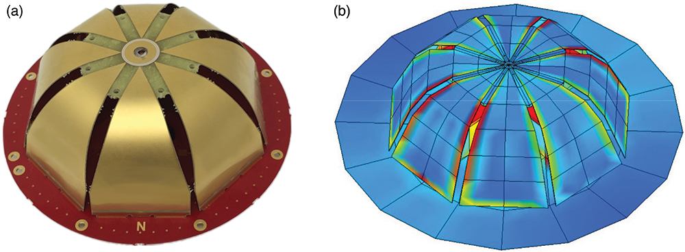
Northrop Grumman Corporation has successfully completed the critical design review (CDR) milestone for the Embedded Global Positioning System/Inertial Navigation System (INS)-Modernization, or EGI-M, program.
EGI-M provides state-of-the-art airborne navigation capabilities with an open architecture that enables rapid responses to future threats. The fully modernized system integrates new M-code capable GPS receivers, provides interoperability with civil controlled air space, and implements a new resilient time capability.
“The completion of this milestone is a key step in bringing necessary navigation capability upgrades to our warfighters,” said Brandon White, vice president, navigation and positioning systems, Northrop Grumman. “With its open architecture and government ownership of the key internal interfaces, EGI-M’s next-generation navigation solution allows the government to quickly insert emerging capabilities from third parties while maintaining cyber security and airworthiness.”
The F-22 is one of the lead platforms for EGI-M integration. (Photo: Staff Sgt. Carlin Leslie/U.S. Air Force)
Northrop Grumman’s unique, modular platform interface design enables backwards compatibility with existing platform footprint and interfaces (A-Kits), allowing current platforms to easily integrate and deploy Northrop Grumman’s EGI-M solution.
At the same time, EGI-M’s modular software and hardware, coupled with government ownership of key interfaces, allows EGI-M to benefit from rapid upgrades with best of breed software and hardware technologies now and in the future.
Northrop Grumman has been on contract for the engineering and manufacturing development (EMD) phase of EGI-M since November 2018. The CDR milestone marks the completion of detailed hardware and software design of the EGI-M product line.
The launch platforms for Northrop Grumman’s EGI-M are the F-22 fighter jet and E-2D early warning aircraft. Additional fixed-wing and rotary-wing platforms across Department of Defense and allied forces have already selected Northrop Grumman’s EGI-M as their future navigation solution.
The E-2D Hawkeye is an American all-weather, carrier-capable tactical airborne early-warning aircraft. (Photo: U.S. Navy)
Effective Sept. 1, Tallysman Wireless Inc. was acquired by Calian Group Ltd. to expand Calian’s reach in the satcom industry to markets requiring smaller antennas used in end-user devices that need a different range of fidelities, according to Patrick Thera, president, Advanced Technologies, Calian.
Calian is a publicly owned Canadian company listed on the Toronto Stock exchange. Its solutions include satellite gateways and infrastructure for RF communications, telemetry, tracking and control systems, space science and earth observation. Calian also provides leading-edge communication products for terrestrial and satellite networks.
Based in Ontario, Canada, Tallysman designs, manufactures and sells a wide range of GNSS, Iridium and Globalstar antennas and related products into a market with a broad range of vertical applications that include precision reference systems, survey, timing, precision agriculture, unmanned and autonomous vehicles, marine and more. The company also produces cloud-based wireless tracking systems over two-way radio systems and 4G category M cellular systems, for applications ranging from school buses to municipal public works.
The company is widely recognized as a technology leader and is the supplier of high-precision antennas to precision GNNS systems providers. Under the Calian umbrella, Tallysman will continue to operate as it has been, with no changes in product availability, fulfilment, support, management or engineering services.
Tallysman will also continue to invest in research and development, and bring new and innovative GNSS products to the market, the company said.
The definitive agreement is valued at up $24.5 million. Amount paid on closing is $15.7 million (net of cash received) and contains two earnout periods of $4M and $4.8M based on the achievement of a certain level of EBITDA performance over the next 30 months. Tallysman’s results will be consolidated and reported with Calian’s Advance Technology segment.
“This important acquisition supports both customer diversification and service line innovation, two key pillars within our four-pillar growth strategy,” stated Kevin Ford, Calian president and CEO. “The Tallysman acquisition demonstrates Calian continued our focus on innovation and growth. The wide range of products and applications Tallysman brings to Calian expands our product line and entry into new markets. We are excited with the opportunity to support innovation in exciting growth industries such as autonomous vehicles, precision agriculture and wearables. We could not be more pleased to welcome Tallysman to the Calian team.”
Sampford Advisors acted as exclusive M&A advisor to Tallysman.
“We are extremely pleased to join the Calian team,” said Gyles Panther, Tallysman president and CTO states. “We look forward to continuing, profitable growth of our core GNSS businesses with products that we sell to a broad customer base. As a member of the Calian family, we also look forward to leveraging additional resources, new technologies and markets deriving from Calian’s deep expertise in satellite communications.”
“Calian welcomes Tallysman to our team,” Thera said. “The Tallysman product line and services add a complementary component to our ground-based satellite communications business. GNSS is one of the fastest growing markets for satellite ground systems and we are excited to join forces with a leader in this field.”
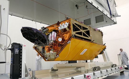
To get the best measurements of Earth’s atmosphere, you sometimes have to leave it. This November, the Sentinel-6 Michael Freilich spacecraft will do just that.
News from the Jet Propulsion Laboratory
When a satellite by the name of Sentinel-6 Michael Freilich launches this November, its primary focus will be to monitor sea-level rise with extreme precision. But an instrument aboard the spacecraft will also provide atmospheric data that will improve weather forecasts, track hurricanes and bolster climate models.
“Our fundamental goal with Sentinel-6 is to measure the oceans, but the more value we can add, the better,” said Josh Willis, the mission’s project scientist at NASA’s Jet Propulsion Laboratory in Southern California. “It’s not every day that we get to launch a satellite, so collecting more useful data about our oceans and atmosphere is a bonus.”
A U.S.-European collaboration, Sentinel-6 Michael Freilich is one of two satellites that compose the Copernicus Sentinel-6/Jason-CS (Continuity of Service) mission. The satellite’s twin, Sentinel-6B, will launch in 2025 to take over for its predecessor. Together, the spacecraft will join TOPEX/Poseidon and the Jason series of satellites, which have been gathering precise sea-level measurements for nearly three decades. Once in orbit, each Sentinel-6 satellite will collect sea-level measurements down to the centimeter for 90% of the world’s oceans.
JPL-developed instrument
Meanwhile, they’ll also peer deep into Earth’s atmosphere with GNSS-RO to collect highly accurate global temperature and humidity information. Developed by JPL, the spacecraft’s GNSS-RO instrument tracks radio signals from navigation satellites to measure the physical properties of Earth’s atmosphere. As a radio signal passes through the atmosphere, it slows, its frequency changes, and its path bends. Called refraction, this effect can be used by scientists to measure minute changes in atmospheric physical properties, such as density, temperature, and moisture content.
The precise global atmospheric measurements made by Sentinel-6 Michael Freilich will complement atmospheric observations by other GNSS-RO instruments already in space. Specifically, the National Oceanic and Atmospheric Administration’s National Weather Service meteorologists will use insights from Sentinel 6’s GNSS-RO to improve weather forecasts.
Also, the GNSS-RO information will provide long-term data that can be used both to monitor how our atmosphere is changing and to refine models used for making projections of future climate. Data from this mission will help track the formation of hurricanes and support models to predict the direction storms may travel. The more data we gather about hurricane formation (and where a storm might make landfall), the better in terms of helping local efforts to mitigate damage and support evacuation plans.
The Sentinel-6 Michael Freilich spacecraft undergoes tests at its manufacturer Airbus in Friedrichshafen, Germany, in 2019. The white GNSS-RO instrument can be seen attached to the upper left portion of the front of the spacecraft. (Photo: Airbus)
A brief history of radio occultation
Radio occultation was first used by NASA’s Mariner 4 mission in 1965 when the spacecraft flew past Mars. As it passed behind the Red Planet from our perspective, scientists on Earth detected slight delays in its radio transmissions as they traveled through atmospheric gases. By measuring these radio signal delays, they were able to gain the first measurements of the Martian atmosphere and discover just how thin it was compared to Earth’s.
By the 1980s, scientists had started to measure the slight delays in radio signals from Earth-orbiting navigation satellites to better understand our planet’s atmosphere. Since then, many radio occultation instruments have been launched; Sentinel-6 Michael Freilich will join the six COSMIC-2 satellites as the most advanced GNSS-RO instruments among them.
“The Sentinel-6 instrument is essentially the same as COSMIC-2’s. Compared to other radio occultation instruments, they have higher measurement precision and greater atmospheric penetration depth,” said Chi Ao, the instrument scientist for GNSS-RO at JPL.
GNSS-RO basics
The GNSS-RO instrument’s receivers track navigation satellite radio signals as they dip below, or rise from, the horizon. They can detect these signals through the vertical extent of the atmosphere — through thick clouds — from the very top and almost all the way to the ground. This is important, because weather phenomena emerge from all layers of the atmosphere, not just from near Earth’s surface where we experience their effects.
“Tiny changes in the radio signal can be measured by the instrument, which relate to the density of the atmosphere,” said Ao. “We can then precisely determine the temperature, pressure, and humidity through the layers of the atmosphere, which give us incredible insights to our planet’s dynamic climate and weather.”
With the help of JPL’s GNSS-RO principal investigator Chi Ao and NOAA’s National Weather Service meteorologist Mark Jackson, this video explains how the GNSS-RO instrument aboard Sentinel-6 Michael Freilich will be used by meteorologists to improve weather forecasting predictions. (Credit: NASA/JPL-Caltech)
But there’s another reason why probing the entire vertical profile of the atmosphere from orbit is so important: accuracy. Meteorologists typically gather information from a variety of sources – from weather balloons to instruments aboard aircraft. But sometimes scientists need to compensate for biases in the data. For example, air temperature readings from a thermometer on an airplane can be skewed by heat radiating from parts of the aircraft.
GNSS-RO data is different. The instrument collects navigation satellite signals at the top of the atmosphere, in what is close to a vacuum. Although there are sources of error in every scientific measurement, at that altitude, there’s no refraction of the signal, which means there’s an almost bias-free baseline to which atmospheric measurements can be compared in order to minimize noise in data collection.
And as one of the most advanced GNSS radio occultation instruments in orbit, said Ao, it will also be one of the most accurate atmospheric thermometers in space.
More on the mission
Copernicus Sentinel-6/Jason-CS is being jointly developed by the European Space Agency (ESA), the European Organisation for the Exploitation of Meteorological Satellites (EUMETSAT), NASA, and the National Oceanic and Atmospheric Administration (NOAA), with funding support from the European Commission and support from France’s National Centre for Space Studies (CNES).
The first Sentinel-6/Jason-CS satellite that will launch was named after the former director of NASA’s Earth Science Division, Michael Freilich. It will follow the most recent U.S.-European sea-level observation satellite, Jason-3, which launched in 2016 and is currently providing data.
NASA’s contributions to the Sentinel-6/Jason-CS mission are three science instruments for each of the two Sentinel-6 satellites: the Advanced Microwave Radiometer, the GNSS-RO, and the Laser Retroreflector Array. NASA is also contributing launch services, ground systems supporting operation of the NASA science instruments, the science data processors for two of these instruments, and support for the international Ocean Surface Topography Science Team.
The 2020 GPS Public Interface Control Working Group Meeting will take place on Sept. 30, announced the U.S. Air Force Space and Missile Systems Center. The meeting includes an open forum to update the public on GPS public document revisions.
The meeting will collect issues and comments for analysis and possible integration into future GPS public document revisions.
The meeting is scheduled from 8:30 a.m. to 4 p.m. (Pacific Standard Time). Portfolio Architect Corp. will host the meeting, which is open to the general public.
Attendees are highly encouraged to participate virtually. The meeting facility in-person capacity may be reduced based on government restrictions; in-person attendees should plan accordingly. Attendees are also expected to comply with COVID–19 health precautions, such as maintaining social distance and wearing a facemask.
Documents Affected
IS-GPS-200: Navigation User Interfaces
IS-GPS-705: User Segment L5 Interfaces
IS-GPS-800: User Segment L1C Interface
ICD–GPS–240 (NAVSTAR GPS Control Segment to User Support Community Interfaces).
Meeting Address:
Coronado Conference Room (17th Floor)
SAIC
200 N Pacific Coast Highway
El Segundo, CA 90245