China will lose access to a strategic space tracking station in Western Australia when its contract expires, a decision that could affect BeiDou constellation service in the Pacific region, according to a Reuters report.
A contract between the Swedish Space Corp. (SSC) and China has given Beijing access to a station antenna since 2011, but the SSC satellite station is primarily used by the United States and its agencies.
The Swedish state-owned company told Reuters it wouldn’t enter into any new contracts at the Australian site to support Chinese customers after its current contract expires, but did not disclose the exact date.
Ground stations are a vital part of space programs given they create a telecommunications link with spacecraft. While stations have different capabilities, they can be equipped to coordinate satellites for civil-military GNSS such as Beidou, Russia’s GLONASS, the European Union’s Galileo system, and U.S.-owned GPS.
China’s space program has been increasing its access to overseas ground stations in recent years in line with the expansion of its space exploration and navigational programs.
“Generally speaking, anywhere you put a GNSS monitoring ground station will improve the accuracy of positioning for that region,” said Joon Wayn Cheong, a senior research associate at the University of New South Wales’ School of Electrical Engineering.
China wants to remove its dependence on GPS as part of broader plans to expand its global influence, says Christopher Newman, professor of Space Law and Policy at Northumbria University in Newcastle, England. “GPS could be made unavailable to them in a military conflict. An independent secure system is crucial for the capabilities of the People’s Liberation Army [China’s military] with respect to targeting, weapons, navigation,” he told Reuters.
Beijing last year reestablished diplomatic ties with the small Pacific island nation of Kiribati, where it has a mothballed ground station.
With advantages provided by geographic information systems (GIS), the demand for GIS in the telecom industry has increased in recent years. According to a report published by Allied Market Research, the global telecom market is anticipated to garner $3.27 million by 2023.
GIS has fortified the telecom industry by reducing costs and augmenting capital planning. GIS mapping can improve outage prediction, resource management and infrastructure determination.
GIS also can help the emerging economies for independent energy, efficient infrastructure, and enhanced communication systems. GIS provides imagery, geocoding, modeling, routing and the required data for these applications.
GIS is rising in popularity as it eases access to critical sources of business intelligence.
Impacts in the telecom industry
GIS mapping supports telecom companies with factors such as enhanced customer service with location data and imagery, efficient resource dispatch, and prompt sharing of location data. This enables telecom industries to track locations and have a better understanding of service layout.
GIS mapping lets companies know the geospatial relationships of their facilities, resources and ground features, and provide faster and more effective customer service.
GIS also helps identify faulty circuits. It can help model the solution online and offer best-case scenarios, resulting in improved operations and enhanced customer service.
GIS mapping also helps the sales and service team understand their targets by tracking multiple layers of geospatial data and providing insight into the customer base.
Information on network structure
Almost every telecom company focuses on offering effective, functioning networks, along with network monitoring, testing of network elements, maintenance and customer services. The real-time network structure offered by GIS solutions enhances these monitoring and service activities.
With GIS, networks get instant access to information such as customers’ history and rank, current network structure, signal quality in precise demography, and any need for maintenance or restoration of services. Moreover, GIS makes the services more reliable and fast.
GIS solutions are also beneficial for determining market demand for future estimations. GIS offers a better understanding of the relationship between customers’ topographical presence and companies’ marketing operations. It helps companies identify networking issues and easily reach customers, along with offering information on other issues.
With its precise geography, GIS helps telecom companies meet service demand and develop budgets for promotional activities and marketing campaigns.
Enhancing telecom services
With computers and mobile devices a necessity for most of us, many telecoms want to expand to provide services in rural areas — a major reason for their adoption of GIS.
Another motivator is the surge in demand for augmented reality and virtual reality, part of the increase in the adoption of GIS for mobile and broadband services.
Smart Cities. GIS provides a platform that works with Customer Relationship Management (CRM) systems, networks, databases, fault management system and wireless location. The demand for growth also depends on the rise in demand for satellite images by companies that provide maps and an increase in government spending to develop and build smart cities.
Moreover, the rising use of technology, the internet, and other digital platforms in rural areas has sparked companies to expand their services.
With companies focusing on broad network coverage, greater connectivity and emerging innovations such as 5G, the field of mobile telecommunications technology is anticipating opportunities to expand market growth.
Akshita Pacholi has a master’s degree in English literature and is working as a content writer with Allied Market Research.
GPS technology is doing far more than helping us navigate or receive accurate time. It is now being used to fight the spread of the global COVID-19 pandemic.
Global navigation satellite systems are being used to collect big data on travel and contact, but they are also being used in more unconventional ways: for example, quarantine enforcement and sanitation technology.
Read on to learn about a few recent developments in the world of GNSS/GPS that are bolstering the battle against the novel coronavirus.
Electronic monitoring enforces quarantine
There is a surge of applying ankle monitors to track sick individuals and deter them from spreading the virus further. According to BloombergBusinessweek, one business is thriving because of it: providers of electronic ankle monitors.
Kentucky courts are requiring GPS ankle monitors for people who test positive for COVID-19 and refuse to self-quarantine. Kentucky couple Elizabeth and Isaiah Linscott were two of a growing number of people placed under house arrest after Elizabeth tested positive for COVID-19 and denied signing the Self-isolation and Controlled Movement Agreed Order, a health department document promising she would stay home.
Photo: Regulus Cyber
Elizabeth told Louisville television station WAVE 3 News that she did not sign because she disagreed with the wording of the document. She said that she was concerned about having to contact the health department before traveling, even in the case of an emergency.
“My part was if I have to go to the ER, if I have to go to the hospital, I’m not going to wait to get the approval to go,” she said.
A few days after Elizabeth refused to sign the paperwork, her husband opened their door to an entourage of law enforcement officers serving them with a Health Department order to wear ankle monitors.
“I open up the door, and there’s like eight different people, five different cars, and I’m like ‘what the heck’s going on?’ This guy’s in a suit with a mask. It’s the Health Department guy, and they have three papers for us. For me, her and my daughter,” Isaiah said.
The Linville family is now confined to a 200-foot radius. If they leave their designated quarantine area, their ankle monitors will alert law enforcement.
Alternative to prison
The number of people on house arrest in the United States and across the world has surged as corrections departments struggle to slow the spread of the coronavirus within prisons. An estimated 25 to 30 percent more people are wearing ankle monitors in comparison with a few months ago, according to Bloomberg Businessweek. The U.S. Federal Bureau of Prisons reported a 160 percent increase in home confinement from late March to July. European corrections departments have similarly put thousands of inmates on house arrest in the last few months.
“Demand has spiked everywhere,” BI Inc. monitoring equipment executive Robert Murnock said to Bloomberg. “We’re getting calls from different jurisdictions and other countries we’ve never worked with.”
Efforts to reduce crowding in prisons mean that the electronic monitoring industry is one of very few industries benefiting financially from the coronavirus pandemic.
“Coronavirus gives electronic monitoring companies an opportunity like they’ve never had before to expand,” parole reform expert James Kilgore said.
On Aug. 3, Singapore announced the rollout of electronic tracking devices to enforce quarantine. Travelers will be required to wear GPS and Bluetooth-powered tracking devices that notify authorities if quarantine is broken or the device is tampered with. The rule went into effect on Aug. 11 and applies to all incoming travelers — resident or nonresident — over the age of 12.
On Aug. 20, the premier of Western Australia, Mark McGowan , said his government could soon force people in hotel quarantine to wear electronic monitoring equipment if they are deemed a risk. “If we identify people who are potential flight risks or who might have a criminal history, we are looking at applying monitoring bracelets to them,” he said.
An estimated 25 percent to 30 percent more prisoners are wearing bracelets now compared to the pre-outbreak period. In the U.S., the Federal Bureau of Prisons has placed about 4,600 inmates in home confinement, a 160 percent increase since the end of March.
“Demand has spiked everywhere,” said Robert Murnock, vice president for partnership development at BI Inc., a provider of EM technology.
The emergency shift to electronic monitoring spurred by COVID-19 may foretell a long-term shift toward use as an alternative to prison time, reducing clutter and the risk of the virus spreading among inmates.
Photo: LeoPatrizi/E+/Getty Images
Contact tracing via mobile phones
Israel is using covert mobile phone data to track the spread of COVID-19. On July 1, the Knesset approved a bill temporarily reauthorizing mass surveillance of coronavirus-infected citizens by the Shin Bet, Israel’s internal security service. The original program lasted from mid-March to June 9.
The contact-tracing program works like this. When a patient is diagnosed with COVID-19, the Israeli Health Ministry provides their personal information — including their mobile number — to the Shin Bet. The Shin Bet then consults a classified database of every person who uses Israeli telecom services to determine who came into contact with the infected individual for more than 15 minutes at a time. After the Shin Bet sends information back to the Health Ministry, the Health Ministry notifies those people via text and tells them to self-quarantine.
The Shin Bet’s newfound role in public health enforcement is quite different from its usual focus. Former Shin Bet agents say the COVID-19 mobile phone tracking technology was originally developed as a counterterrorism measure, and the tracking system being used on Israeli civilians is almost identical to that used for suspected terrorists.
“It’s the same system, the same methods,” retired Shin Bet agent Arik Brabbing said to BBC. “We know that someone was here in the park. We can get from the [mobile phone] company all the details about the hour, the place, exactly the place… and we can understand who else was around.”
Supporters of the mass surveillance program, including Prime Minister Benjamin Netanyahu, argue that reduced privacy is necessary to curb the spread of the virus. However, the Israeli government has come under fire by opponents who claim that the program is intrusive and undemocratic.
Israel’s contact tracing procedures are more secretive than those of South Korea and Taiwan, other countries that mandate central mass surveillance. South Korea and Taiwan both enforce quarantines with mobile-phone tracking, and both have built publicly available COVID-19 data platforms.
The South Korean government has disseminated detailed — but anonymized — information about COVID-19 carriers, including their travel routes and treatment facilities. Citizens broadly support these measures — a testament to collectivism in Korean culture.
Civic engagement and enthusiasm for fighting the pandemic is also remarkable in Taiwan, where the public has been collaborating with the government on a town hall-style website called vTaiwan. Citizen-led initiatives, like a GPS-powered tool for tracking face mask supplies, have been applied nationwide.
Meanwhile in Europe, eight major telecom companies, including Vodafone and Orange, have been supplying anonymized metadata to the European Commission to model and predict the spread of the virus. In the United States, the Centers for Disease Control and Prevention is soliciting GPS data from mobile advertising companies rather than carriers themselves.
The two tech giants, Apple and Google, made it easier for health agencies to join its coronavirus exposure notification system, creating a new built-in app within iOS and Android. The app provides real-time notification to users when they are exposed to a sick person.
Virus-killing robots may roam the streets
GPS-based robots, drones and autonomous cars are being deployed to sanitize outdoor spaces, transport medical equipment, and announce safety information to the public.
Robots began rolling around the streets of Wuhan, the original epicenter of the coronavirus outbreak, as early as January. China was the first to deploy robots of this type, but India, Spain, France and other countries have followed in their footsteps. In addition to the chemical-spray approach, some companies are pioneering mobile disinfection robots armed with large ultraviolet-C germicidal lights.
Apollo, the autonomous vehicle company of multinational internet giant Baidu, has partnered with Chinese self-driving startup Neolix to transport food and supplies to Beijing Haidian Hospital. Every morning at 10:30 a.m, an unmanned car delivers meals to about 100 frontline workers. The process eliminates direct contact, protecting the safety of food service workers, hospital staff, and patients.
Zhangjiang Artificial Intelligence Island
A fleet of Apollo and Neolix’s unmanned cars is also responsible for disinfecting all roads on Zhangjiang Artificial Intelligence Island, an 100,000-square-meter industrial complex in Shanghai. The vehicles are loaded with up to 160 liters of spray disinfectant and can cover the island’s entire road system in about half an hour.
The vehicles at Zhangjiang AI double as nighttime surveillance bots. They patrol the island and make sure that guests are adhering to coronavirus protocols, alerting security personnel if they note suspicious activity.
In addition to using drones to spray disinfectant, South Korea’s government has leveraged the technology for public announcements. On July 4, 300 drones lit the sky above Seoul in a show of appreciation for frontline workers. The drones executed a 10-minute synchronized show that included images of face masks, hand washing, and social distancing.
Summary
As COVID-19 continues to ravage the globe, governments rely on GPS to track the virus, contain it, and fight against it. The battle against coronavirus is still being waged on a global scale, utilizing GPS as a weapon along with many other existing technologies.
The pandemic changed the world forever, and it also highlighted the power of tracking and monitoring location of people and machines. It is another testament to the immense reliance on GPS technology in our modern world.
The increased deployment of these technologies necessitates increased security measures, especially when public health is on the line. Regulus Cyber offers GPS Cybersecurity software. To read more about it, visit www.regulus.com.
Service opens a new era of satellite navigation performance augmentation in the Africa and Indian Ocean Region
The Agency for Air Navigation Safety in Africa and Madagascar (ASECNA) has started to broadcast a satellite-based augmentation system (SBAS) signal over Africa and the Indian Ocean (AFI) region.
This is the first SBAS open service in this part of the world, according to Thales Alenia Space. The signal is broadcast via the NIGCOMSAT-1R satellite managed and operated by Nigerian Communications Satellite Ltd. under the Federal Ministry of Communications and Digital Economy of Nigeria.
The early open service is provided as part of the “SBAS for Africa & Indian Ocean” program, which pursues the autonomous provision over the continent of SBAS services to augment the performances of the satellite navigation constellations GPS and Galileo.
With improved accuracy to within a meter — and boosted integrity, availability and continuity of safety-related applications — the SBAS services will improve flight safety and efficiency in Africa. It will also benefit the economy in land, sea and rail transport areas, as well as mass-market applications, supporting user safety, cost-effectiveness and sustainable development.
Early Service Goals
The launched open service aims to carry-out technical trials, and to undertake with partner airlines field demonstrations for aircraft to demonstrate the benefits of the future operational safety-of-life SBAS services, expected in 2024. It will also include early precise point positioning (PPP) and emergency warning service, both to be demonstrated.
The signal in space is generated by a dedicated system testbed, developed as part of the “SBAS for Africa and Indian Ocean” preliminary design phase, financed by the European Union and awarded to a Thales Alenia Space joint venture between Thales (67%) and Leonardo (33%). The system prototype uses the SAGAIE reference station network deployed by CNES and ASECNA with the support of Thales Alenia Space.
The signal is broadcast via the SBAS payload on Nigcomsat-1R GEO satellite of the Nigerian Communications Satellite and an uplink station deployed in Abuja (Nigeria). It is compliant to the Standards and Recommended Practices of the International Civil Aviation Organisation, and the Minimum Operational Performance Standard developed by the RTCA (Radio Technical Commission for Aeronautics) organization. It will be visible in the whole Africa and Indian Ocean, up to the West Australian coast, and also in Europe.
“We are proud to be part of this ambitious program to provide satellite navigation services in the Africa and Indian Ocean region. The use of our geostationary communication satellite Nigcomsat-1R navigation payload to broadcast the first signal will be Africa’s premier contribution to SBAS as a regional satellite-based augmentation system for the continent,” said Abimbola Alale, MD/CEO of NIGCOMSAT Ltd.
“Our long-standing expertise acquired with the development of EGNOS SBAS in Europe and KASS SBAS in Korea combined with our new leading-edge satellite positioning technologies makes Thales Alenia Space the ideal partner to best support countries to implement their own SBAS efficiently. The equatorial region represents also a key engineering challenge for such a system due to difficult ionosphere conditions, for which Thales Alenia Space has developed a proven solution,” said Benoit Broudy, vice president of the Navigation business at Thales Alenia Space in France.
“The provision of the first African SBAS early service is a crucial major step forward in the development of satellite navigation in the AFI Region, and in the deployment of the ‘SBAS for Africa and Indian Ocean’ system, the navigation solution for Africa by Africa. It demonstrates the ambition and commitment of ASECNA to enhance air navigation safety for the benefit of the whole continent, in line with my vision for the unification of the African Sky,” stated Mohamed Moussa, director general of ASECNA.
About ASECNA
ASECNA is an international public organization. Its main mission is to provide air navigation services within an airspace of 16,500,000 square kilometers, divided into six flight information regions (F.I.R) as defined by the International Civil Aviation Organization (ICAO).
ASECNA also develops solutions for airport management, aviation infrastructure studies and construction, equipment maintenance, calibration of air navigation instruments and training for civil aviation staff.
Its 18 Member States are: Benin, Burkina Faso, Cameroon, Central African Republic, Comoros, Congo, Côte d’Ivoire, France, Gabon, Guinea Bissau, Equatorial Guinea, Madagascar, Mali, Mauritania, Niger, Senegal, Chad and Togo.
Bernard Gruber, who previously headed the GPS program for the United States Air Force, has joined the GPS World Editorial Advisory Board.
Gruber is senior director of Guided Projectiles and Precision Weapons, Innovation Systems, at the Armament Systems Division of Northrop Grumman in Plymouth, Minnesota. In this role, he is responsible for the capture and program execution of multiple U.S. Department of Defense and global programs within five business lanes:
Precision Guidance Kits
Advanced Weapons
Barriers/Area Denial Systems
Air Defense/Counter-Unmanned Aircraft Systems (C-UAS)
Air-to-Ground Precision Weapons
Gruber joined Northrop Grumman (then ATK) in September 2013, where he was responsible for winning and managing cost, schedule and technical performance of a significant international co-production program before moving on to deputy for precision weapons and then senior director in 2015.
Before joining Northrop Grumman, Gruber completed a distinguished 26-year Air Force career and retired as the program director of the Global Positioning System (GPS), Los Angeles Air Force Base. As GPS director, he was responsible for development, acquisition, fielding and sustainment of all GPS satellites, command and control (ground segment) and military user equipment.
The $32 billion GPS program, with a $1 billion annual budget and 700 member team, maintained the largest satellite constellation and the largest avionics integration and installation program in the entire DOD.
Gruber earned his B.S. in mechanical engineering from North Dakota State University and his M.B.A. from Michigan. He is a graduate of Squadron Officer School, Air Command and Staff College, Air War College, Defense Systems Management College and the Joint Forces Staff College; he has commanded at the squadron, group and wing levels.
Gruber has distinguished himself in a variety of leadership positions within the operations, intelligence, launch, engineering and acquisition disciplines, and had served in key positions at Major Command, Air Staff, Joint Staff, Corporate and Defense Agency levels. He is a National Defense Fellow, life member of the Air Force Association, National Eagle Scout Association, Program Management Institute and sits on the board of directors for AirSpace Minnesota and the Midwest Defense Alliance.
Northrop Grumman is a global security company providing innovative systems, products and solutions in autonomous systems, cyber, C4ISR, strike and logistics and modernization to customers worldwide.
Eos Locate for Collector for ArcGIS underground mapping is now compatible with three Subsite Electronics products.
Introduced in 2019 by Eos Positioning Systems, Eos Locate is a real-time, survey-grade solution for mapping underground utilities with ArcGIS field apps. With Eos Locate, one field worker can collect both GNSS locations and locator data (such as depth below cover) for any buried asset including water, sewer, electric, cable, gas, fiber infrastructure and more. They can do so quickly, accurately and without the need for any additional field or office support.
The solution requires an Arrow GNSS receiver, Esri licensing, an iOS device, and a compatible locator.
This expansion adds compatibility for two new utility locator models and one HDD guidance system: the UtiliGuard (with Bluetooth option enabled), UtiliGuard 2, and TK Recon. Eos Locate for Collector combines three core technologies: Eos Arrow GNSS receivers, Esri Collector and the Vivax-Metrotech vLoc Series of locator devices.
“We are extremely excited to expand this popular underground mapping solution to Subsite Electronics customers,” said Eos Chief Technology Officer Jean-Yves Lauture. “Utilities have been asking us to add compatibility, and we are pleased to announce that this integration is now available today, for no extra cost, to our existing customers.”
“At Subsite, we are constantly listening to customer needs and providing solutions accordingly,” Subsite Electronics Senior Product Manager Christopher Thompson said. “We have a lot of customers who perform this type of work, and by partnering with Eos, we are able to provide a solution today to continue providing our customers with the tools and technology for total underground awareness.”
Thanks to the TK Recon integration, it is now possible to map horizontal directional drilling operations in real-time with Eos Locate, for both performing as-built reports and monitoring.
To use Eos Locate with Subsite devices, customers must download Eos Tools Pro (version 1.89 and higher) from the App Store for free. Eos Locate is compatible with both Esri ArcGIS Collector and ArcGIS Field Maps. Follow this manual or watch these video tutorials to get started.
The European GNSS Agency (GSA) has launched the MyGalileoSolution competition. The contest is targeting European innovators and entrepreneurs ready to develop location-based solutions, such as mobile applications, wearable-based solutions, asset management and tracking solutions, or robotics, leveraging Galileo as a source of positioning, navigation and/or timing. A wide participation from all Member States is expected.
GSA has a successful track record in supporting and boosting GNSS-based innovative applications. For years, the agency has been leading several research and innovation initiatives such as the Galileo Masters, Horizon 2020 projects, and more recently European competitions like the 2019 MyGalileoApp and Hackathons across Europe and beyond.
Two tracks for 56 prizes
With a prize pool of almost € 1.5 million, MyGalileoSolution is the largest competition ever organized by the GSA. It consists of two independent and parallel tracks, each one with a list of goals and deliverables.
Track 1 , From Idea to Prototype, aims to develop a beta version of an application or a prototype of a solution implementing an idea, reaching a minimum of 50% of its functionality.
Track 2, From Prototype to Product, aims to develop a fully functional solution ready to be commercialised starting from a beta version of an application or a prototype.
Participants are expected to leverage Galileo’s robust positioning and accurate timing and synchronization capabilities, showing how it can enable the development of the next generation of applications and services across a wide range of areas. In this competition the GSA is challenging innovators in four different areas: Crisis & Emergency Response, Smart Transport for Green Deal, Solution for Digital Age, and Cybersecurity.
Galileo for location-based services
With more than 1.5 billion Galileo-enabled smartphones and more than 51 million GNSS-enabled wearable devices in the market, location-based services (LBS) are booming. Accurate positioning and timing are at the heart of the growth and evolution of LBS, in addition the access to Android GNSS raw measurements has allowed for the creation of advanced GNSS positioning algorithms that enable the development of more ambitious smartphone-based applications.
‘’Galileo has set the trend for dual-frequency chipsets, which provide better accuracy and are more resistant to multipath in urban environments,” said Pascal Claudel, GSA acting executive director. “We are looking forward to seeing innovators launching their disruptive GNSS solutions and turning them into real businesses, hence leading to European growth, competitiveness and sustainability. There is ‘space’ for all types of innovation and we expect the participation of all Member States.”
“Competitions like MyGalileoSolution are a great opportunity to quickly move from idea to market,” said Francesco Fiorito, leader of Argeo, the winning team of the 2019 MyGalileoApp competition. “It is a confidence boost for young entrepreneurs and their capacity to grow and generate new solutions and business,” Claudel concluded.
Deadlines and more information
The deadline for submission for both categories is Sept. 30. Projects will be evaluated in terms of their innovative nature, market potential, feasibility and Galileo relevance by a panel of GSA experts.
Sensonor has launched two new navigation devices. The high-accuracy tactical-grade STIM277H gyro module and STIM377H inertial measurement unit (IMU) are based on experiences and requirements from serving customers in the space segment during the past decade.
The modules have a hermetic aluminum enclosure with a glass-to-metal sealed electrical micro-d connector and a laser-welded lid to secure long-term hermetic operation.
All parts are tested for fine and gross leak to conform to MIL-STD-883J, Class H. The hermetic enclosure protects the system from the external environment and ensures long-term reliability to meet requirements within the space segment and other applications needing exceptional long-term reliability.
The design is tested for a 20+ years’ operating life through high-temperature operating life (HTOL) testing. STIM277H and STIM377H are electrically and mechanically backward-compatible with Sensonor’s other IMU and gyro modules, and provide users with an easy implementation into an existing design.
The components come in dust-free clean-room packaging and have SurTec650 as the only surface treatment. The components are International Traffic in Arms Regulations (ITAR)-free, and have a range of features that can be configured by the customer.
While the new part is still a commercial off-the-shelf (COTS) product and not space-qualified, Sensonor has carried out extensive radiation characterizations to understand the capability of the parts. This data is available on request from Sensonor or can be downloaded.
The parts are a good fit for satellite attitude and orbit control systems (AOCS), launchers, portable target acquisition systems, UAV payloads, land navigation systems, turret stabilization, missile stability and GNSS-supported navigation systems.
The extended-range data call milestone was completed in Janesville, Wisconsin, over a more than 5-km distance with speeds greater than 100 Mbps. According to the companies, the achievement redefines the perception of 5G mmWave spectrum as an urban- or high-density-only deployment technology and offers new opportunities to use current infrastructure for broader 5G coverage.
This milestone demonstrates that mmWave can help close the “connectivity divide” and expand broadband services throughout rural, suburban, and urban communities. This breakthrough gives communications service providers a cost effective way to expand their coverage and deliver 5G experience to communities that previously were not serviced or may have lacked a reliable connection.
It will also open the door for new use cases, which will bring 5G benefits to homes and business everywhere, from urban to rural communities. For example, Fixed Wireless Access (FWA) installations can provide a cost-effective way to deliver fiber-like internet speeds wirelessly over mmWave to institutions such as schools, hospitals and town halls, and for addressing some of the “last mile” challenges in rural areas. FWA provides the bandwidth required to support high definition streaming services that can improve experiences like remote education and remote healthcare in suburban and rural environments.
Mike Irizarry, chief technology officer, U.S. Cellular, said, “This is a key strategic milestone in our 5G evolution. Expanding 5G mmWave coverage enables us to offer high-speed broadband services to consumers and businesses in rural areas and underserved communities and reinforces our commitment to technological leadership for rural America. It is a concrete example where U.S. Cellular is driving innovation leadership in extended range technology from Ericsson and promoting the high-power device ecosystem enabled by Qualcomm Technologies.”
“This major milestone of using mmWave for an extended-range 5G data transfer is paving the way to implement fixed broadband services for broad coverage in urban, suburban and rural environments,” said Alejandro Holcman, senior vice president, engineering, Qualcomm Technologies. “With the introduction of the Qualcomm QTM527 mmWave antenna module as part of the Qualcomm Snapdragon X55 5G Modem-RF System, we are empowering operators and OEMs to offer high-performance, extended-range multi-gigabit 5G broadband to their customers — which is both flexible and cost-effective, as they can leverage existing 5G network infrastructure.”
Per Narvinger, head of product area networks, Ericsson, said, “Ericsson is constantly pushing the boundaries of 5G technology to bring its benefits everywhere across the globe. Ericsson has a long and successful track record in extending coverage across generations of mobile technologies. Working with our partners, Ericsson has now demonstrated the commercial viability of long-range 5G radio capability for mmWave spectrum.”
The milestone was achieved by applying extended-range software to commercial Ericsson hardware — including AIR5121 and Baseband 6630 — and a 5G CPE device powered by the Snapdragon X55 5G Modem-RF System with the Qualcomm QTM527 mmWave antenna module.
An autonomous ship launched Sept. 16 on a mission to traverse oceans and gather vital environmental data, guided by GNSS and inertial measurement units (IMUs).
Ocean research non-profit ProMare joined with IBM on the Mayflower Autonomous Ship (MAS) — an artificial intelligence (AI) and solar-powered marine research vessel. Following two years of design, construction and training of its AI models, the fully-autonomous trimaran was launched from Plymouth, England.
The ship is guided by both GNSS and IMU technology. It uses two Hexagon | Veripos LD8 receivers, each with two V560 marine antennas. The onboard IMUs include an iXBlue Octans and two Silicon Sensing AMU30s.
Designed to provide a safe, flexible and cost-effective way of gathering data about the ocean, the new-generation Mayflower promises to transform oceanography by working in tandem with scientists and other autonomous vessels to help understand critical issues such as global warming, micro-plastic pollution and marine mammal conservation.
ProMare is coordinating the scientific studie,s working with IBM Research and leading scientific organizations.
MAS features an AI captain built by ProMare and IBM developers that gives MAS the ability to sense, think and make decisions at sea with no human captain or onboard crew. The new class of marine AI is underpinned by IBM’s latest advanced edge computing systems, automation software, computer vision technology and Red Hat Open Source software.
“Able to scan the horizon for possible hazards, make informed decisions and change its course based on a fusion of live data, the Mayflower Autonomous Ship has more in common with a modern bank than its 17th century namesake,” said Andy Stanford-Clark, Chief Technology Officer, IBM UK & Ireland. “With its ability to keep running in the face of the most challenging conditions, this small ship is a microcosm for every aspiring 21st century business.”
Artie — short for Artemis and artificial Intelligence — is a stowaway hitching a ride on the Mayflower who answers questions about the ship, the ocean or himself on mas400.com. (Photo: IBM)
Interactive web portal follows voyage
To enable followers around the world to stay updated with MAS as it undertakes its various missions, IBM and ProMare have also launched an interactive web portal. Built by IBM iX (the business design arm of IBM Services), the MAS400 portal is designed to provide real-time updates about the ship’s location, environmental conditions and data from its various research projects.
Live weather data is streamed from IBM’s The Weather Company, as MAS receives forecast data and insight from the new IBM Weather Operations Center.
‘Octopus’ aboard answers questions
The portal even features a seven-armed, stowaway octopus chatbot called Artie, who claims to be hitching a ride on the ship. (With seven arms, he’s technically a septopus.) Powered by IBM Watson Assistant technology and created in partnership with European startup Chatbotbay, Artie has been trained to provide information about MAS and its adventures in a lively, and accessible format.
“MAS400.com is one of the most advanced ocean mission web portals ever built,” says Fredrik Soreide, Scientific Director of the Mayflower Autonomous Ship project and Board Member of ProMare. “Protecting the ocean depends on our ability to engage the public in important matters affecting its health. This MAS400 portal is designed to do exactly that and tell people where the ship is, what speed it’s travelling at, what conditions it’s operating in and what science we are conducting. Users can even help Artie the Octopus fish out surgical masks, cigarette butts and other increasingly common forms of ocean litter from a virtual ocean of facts and data.”
MAS will spend the next six months in sea trials and undertake various research missions and voyages before attempting to cross the Atlantic in Spring 2021. MAS’s transatlantic voyage will be based on a similar route and pioneering spirit to the 1620 Mayflower which made the same crossing 400 years ago.
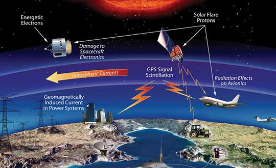
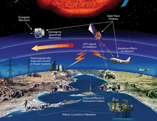
The effects of space weather on critical Earth systems. (Image: NASA)
The United States Congress has passed bipartisan legislation to address how the government deals with threats posed by emissions from the Sun to critical infrastructure such as GPS.
The Promoting Research and Observations of Space Weather to Improve the Forecasting of Tomorrow (PROSWIFT) Act S.881 now awaits signature by the president.
The bill sets forth provisions to improve the ability of the United States to forecast space weather events and mitigate its effects.
It provides statutory authority for the National Science and Technology Council’s Space Weather Operations, Research, and Mitigation Working Group, which coordinates executive branch efforts to understand, prepare, coordinate, and plan for space weather.
The bill directs the Office of Science and Technology Policy, National Oceanic and Atmospheric Administration (NOAA), National Science Foundation, Air Force, Navy, National Aeronautics and Space Administration (NASA), National Security Council, and Federal Aviation Administration (FAA) to carry out specified space weather activities.
The legislation
assigns roles and responsibilities to agencies involved in space weather research and forecasting
ensures agency coordination to better predict severe space weather events and mitigate impacts
calls for coordination between the government and the non-governmental space weather community including academia, the commercial sector and international partners.
Senators Gary Peters (D-MI) and Cory Gardner (R-CO) introduced the first version of the bill in 2016 and a successor passed the Senate in 2017. Reps. Ed Perlmutter (D-CO) and Mo Brooks (R-AL) shepherded it through the House, which passed it Sept. 16.
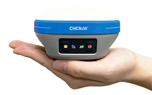
An IMU-RTK GNSS receiver that fits in your hand and a fully integrated GNSS base station add a new scale to GNSS surveying applications.
CHC Navigation (CHCNAV) has announced the immediate availability of the i73 GNSS, a versatile pocket-sized IMU-RTK GNSS rover with an integrated inertial module and the iBase GNSS, a rugged base GNSS receiver.
The combination of the i73 GNSS and the iBase GNSS offers a productive and affordable solution for measuring and staking out points in any surveying, mapping or construction application.
“Surveyors and construction professionals are forced to carry heavy and cumbersome GNSS receivers in most situations, resulting in unnecessary fatigue and lower productivity,” said Hans Huang, product manager of CHC Navigation’s Survey and Engineering Division. “Taking this into account, we have developed our pocket-sized i73 GNSS, the lightest GNSS rover powered by the latest IMU-RTK technology, and much more. Our iBase GNSS station follows the same concept of an all-in-one solution, making the need for external radio modems and other bulky accessories obsolete.”
The i73 Pocket IMU-RTK GNSS: A new scale to GNSS
The i73 Pocket IMU-RTK GNSS. (Photo: CHCNAV)
Weighing only 730 grams yet with 15 hours of operating time, the i73 GNSS is one of the lightest and most rugged RTK GNSS receivers on the market.
Easy to carry and use, the i73 will not tire out field workers. It offers superior GNSS signal tracking enables surveys beyond the usual constraints. It features full 624-channel GNSS technology and connects seamlessly to RTK GNSS networks as well as to UHF GNSS station over its embedded UHF modem.
Automatic pole-tilt compensation. The i73 GNSS internal interference-free inertial module (IMU) allows automatic pole tilt compensation of up to 45 degrees. Projects are completed 30% faster and with increased efficiency and safety when measuring hard-to-reach points.
The iBASE GNSS: Redefining the concept of GNSS base station
The iBASE GNSS receiver. (Photo: CHCNAV)
The GNSS iBase is a fully integrated GNSS base station, specifically designed to meet 95% of surveyors’ needs when working in UHF GNSS base and rover mode. The performance of the iBase UHF base station compared to a conventional external UHF radio modem is virtually identical. But its unique design eliminates the need for a heavy external battery, bulky cables, an external radio, and a radio antenna. Its 5-watt radio module provides operational GNSS RTK coverage up to 8 km.