The draft EUROCAE document ED-348: Guidelines for the use of multi-GNSS solutions for UAS – Medium Risk is now open for comments.
Between 2019 and 2022, EUROCAE group SG-6 developed guidelines for low risk operations Sail I and Sail II (ED-301) to support the use of GNSS and show compliance with previously established safety objectives (SORA OSO#13).
SORA OSO#13 is also applicable to higher SAIL operations with a different level of assurance, which may take the form of a service level agreement (SLA) with external GNSS service providers. This changes the approach with respect to low-risk operations, so a new standard will be defined instead of evolving ED-301.
“When discussing the use of GNSS in UAS operations, the assessment cannot be limited to GNSS as an external service only, but should consider other critical aspects such as system architecture, vulnerabilities, performance analysis, receiver design or integration, among other elements,” SG-6 posted on the EUROCAE website.
Because the requirements for medium-risk operations are more demanding than for low-risk operations, the scope of the ED-348 document not only covers compliance with OSO#13 requirements — where GNSS is considered an external service to support UAS operations — but also considers other relevant SORA OSOs where GNSS plays a relevant role.
Based on this information, the guidelines cover the following OSOs in regard to GNSS support SAIL III operations:
OSO#05: UAS is designed considering system safety and reliability.
OSO#08: Operational procedures are defined, validated and adhered to.
OSO#13: External services supporting UAS operations are adequate to the operation.
OSO#23: Environmental conditions for safe operations are defined, measurable and adhered to.
OSO#24: UAS is designed and qualified to operate under adverse environmental conditions.
Interested parties are invited to review the proposed draft on the EUROCAE Workspace and complete the comment form. Non-members of EUROCAE can register and click on “Access only to Open Consultation”). Early replies are encouraged; the deadline for comments is Feb. 2, 2026.
The non-profit European Organisation for Civil Aviation Equipment (EUROCAE) is based in Lucerne, Switzerland, and serves as a European forum focusing on electronic equipment for air transport.
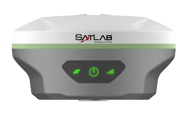
SatLab Geosolutions has launched a new GNSS receiver, the SL8. The SatLab SL8 Laser RTK combines dual cameras, GNSS, an inertial measurement unit (IMU) and visible laser technology to make surveying faster and easier.
With non-contact measurement, image-assisted targeting, CAD live-view stakeout, and a built-in LoRa radio. It ensures smooth, reliable work even in complex or GNSS-limited environments, SatLab said.
Photo: SatLab
The SL8 achieves 2 cm accuracy within 10 meters and enables efficient data collection across bridges, tunnels, riverbanks, and other sites where traditional GNSS methods are restricted.
It features image-assisted targeting through SatSurv software, displaying laser points directly on real-time images for quick and precise aiming. Its automotive-grade IMU requires no manual calibration or initialization and enhances measurement accuracy by up to 40% in GNSS-challenged areas.
A built-in multi-protocol LoRa transceiver provides stable transmission beyond 15 km and compatibility with multiple RTK brands. The integrated CAD and visual stakeout functions combine live imagery with CAD data, allowing users to visualize target points on site and increase layout efficiency by up to 50%.
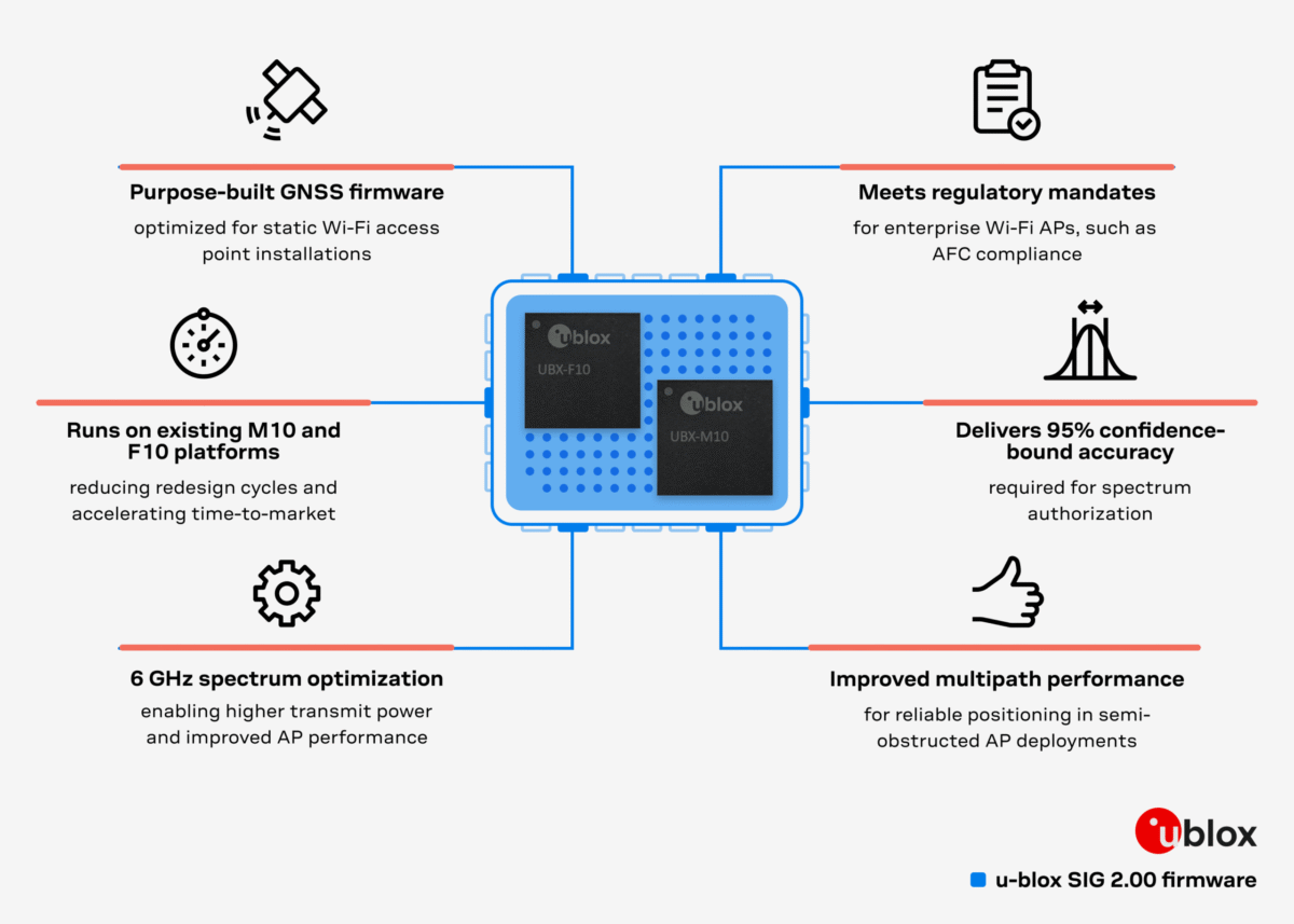
Dedicated firmware delivers AFC-compliant geolocation and adheres to 6 GHz spectrum rules, accelerating deployment of location-enabled Wi-Fi infrastructure.
U-blox has released Standard Infrastructure GNSS (SIG) 2.00, a dedicated GNSS firmware solution for Wi-Fi 6E/7/8 access points operating in the 6 GHz band.
Designed to meet Automated Frequency Coordination (AFC) requirements in the U.S. and Canada, SIG 2.00 enables access points to determine their geolocation with 95% confidence-bound accuracy. It also delivers improved positioning accuracy under multipath environments, ensuring AFC systems receive reliable geolocation data.
Compatible with the u-blox M10 and F10 platforms, the firmware simplifies compliance processes and speeds up integration, helping OEMs deploy high-performance, location-enabled Wi-Fi networks quickly and at scale.
Turnkey geolocation for regulatory-ready 6 GHz deployments
As Wi-Fi infrastructure expands into the 6 GHz band, compliance with regional spectrum regulations becomes essential for Standard Power operation. SIG 2.00 offers a ready-to-integrate GNSS solution that meets these requirements out-of-the-box, reducing design effort while ensuring operational reliability.
Its precise location reporting enables Wi-Fi 6E/7/8 access points to coexist safely with incumbent users of the 6 GHz band, such as microwave and satellite services.
Flexible design options on M10 and F10 platforms
SIG 2.00 runs on two established u-blox GNSS platforms. On u-blox M10, it offers a cost-efficient single-band (L1) ultra-low-power solution for mainstream deployments. On u-blox F10, it provides a dual-band (L1/L5) GNSS with RAW data output, delivering enhanced robustness in multipath or dense environments.
This flexibility allows OEMs to meet a wide range of performance and integration requirements while achieving 95% confidence-bound accuracy and maintaining regulatory compliance.
By removing complexity from AFC compliance, SIG 2.00 supports rapid design-in for enterprise and industrial Wi-Fi deployments, from campuses and stadiums to city-wide infrastructure. With robust positioning accuracy and streamlined integration, it helps accelerate the adoption of high-performance, location-enabled wireless networks in the 6 GHz band.
The 5G PNT network in Santa Clara County will mark the first real-world demonstration of a 5G-powered backup to GPS
NextNav Inc., a leader in next-generation terrestrial positioning, navigation, and timing (PNT) and 3D geolocation solutions, will commence operations of a 5G PNT network in Santa Clara County, California, as early as Dec. 11.
Network operations of positioning, navigation and timing applications represent the next milestone toward commercial readiness and the mission to deliver a resilient complement to GPS.
The 5G PNT network will consist of multiple fixed base station locations using a standards-compliant 5G signal with a positioning reference signal (PRS) enabled, a standalone 5G core, and NextNav’s 3D PNT architecture. The network’s authorized technical parameters will align with those in NextNav’s proposal to optimize the lower 900 MHz band to enable a terrestrial, widescale backup to GPS that is broadly available to critical infrastructure, public safety and American consumers.
“We’re incredibly pleased to continue demonstrating our technology in a real-world operational environment,” said Mariam Sorond, CEO of NextNav. “Activating this network is a critical step in our commercialization process, proving that robust 5G broadband service and high-integrity PNT can be delivered together, at scale, using standard 5G equipment.”
The 5G PNT network will validate NextNav’s 5G PRS-based PNT end-to-end architecture under real-world conditions.
“This is the first public demonstration of a full-scale and operational 5G-based PNT in live deployment, delivering both resilient PNT and broadband service simultaneously,” said Arun Raghupathy, NextNav Co-Founder and CTO. “Through this commercialization deployment, we’re validating our 5G-based network can deliver accurate 3D location, improved timing synchronization, and enhanced resilience. This real-world deployment is critical to establishing U.S. leadership in next-generation PNT technologies.”
The 5G PNT network will support the broader adoption of 5G-based terrestrial PNT with 5G broadband capabilities for operators, enterprises and ecosystem partners. This deployment will also prove that NextNav’s software solution is ready to scale and deliver commercial PNT while serving the critical national security and public safety needs of the United States.
AeroVironment has integrated its visual navigation system (VNS) kit with the Puma Long Endurance (LE) small unmanned aircraft system, delivering GNSS-denied navigation capability to ensure mission success.
First introduced in 2022 for the Puma 2 AE and Puma 3 AE, the VNS kit uses advanced computer vision and onboard processing to deliver precise, GNSS-independent navigation. Its integration into Puma LE now extends this capability across the full Puma family for greater flexibility and resilience in degraded or denied environments.
“Assured navigation is critical to the mission, especially as GNSS becomes an increasingly vulnerable resource,” said Jason Hendrix, Vice President of Small Uncrewed Systems for AV. “By fusing visual and inertial data in real time, the system enables uninterrupted flight paths, accurate geolocation, and mission continuity in unreliable GNSS regions.”
Using a suite of downward-facing sensors, cameras and onboard computing, the VNS kit performs visual inertial odometry (VIO) to capture and analyze terrain imagery, estimating true aircraft position in real time. The system fuses continuous visual data from the cameras with motion inputs from onboard inertial sensors to calculate precise position, velocity, and orientation — allowing the aircraft to know where it is and where it is going when GNSS is not available. It automatically transitions between GNSS-enabled and GNSS-denied modes with zero pilot input, ensuring uninterrupted mission continuity in contested environments.
In September, AV announced several upgrades to the Puma LE platform that include the integration of a Laser Target Designator and the release of the Universal Gimbal Kit, enhancements that evolve Puma LE beyond ISR into a cutting-edge precision-engagement system.
“Every upgrade to Puma LE, including the addition of the VNS kit and our new laser designator and gimbal capabilities, is driven by one goal: giving the warfighter greater confidence, flexibility, and capability,” said Trace Stevenson, president of Autonomous Systems at AV. “These recent releases are a great example of AV constantly evolving our platforms to ensure they are at the forefront of technology and providing best in class capability to the warfighter.”
The VNS Kit is designed as an add-on option for new Puma 3 AE or Puma LE system orders and as a retrofit kit allowing existing Puma 2 AE, Puma 3 AE, and Puma LE customers to upgrade fielded systems. The compact two-piece add-on installs into existing Pumas with minimal impact on performance and fits within the standard Puma cases for efficient mission packout. The standard Puma LE system weighs 23.8 pounds and offers 6.5 hours of endurance, a 60-kilometer range, is inaudible at 500 feet and features tool-free payload swaps for seamless transitions between intelligence, surveillance and reconnaissance (ISR), targeting, and other mission sets.
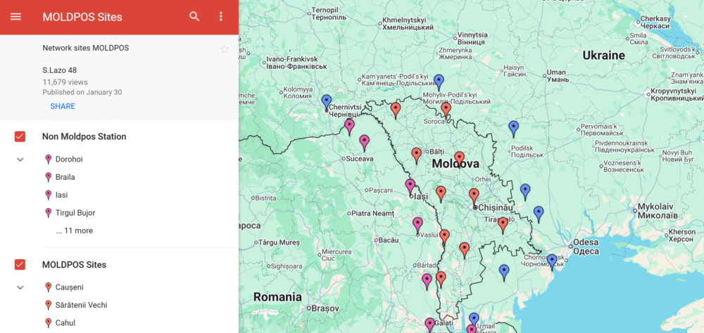
The MOLDPOS National Positioning System in Moldova has been integrated into the European Position Determination System (EUPOS), a pan-European GNSS augmentation service.
The MOLDPOS navigational system uses both GPS and GLONASS, and now Galileo has been added, according to Anatol Ghilas, director of the Agency of Land Relations and Cadastre (ALRC) of Moldova. Ghilas said the question of integration with the European system of Galileo was often discussed, and is a step forward in promoting the positioning technology.
Creation of MOLDPOS was gradual. First, sites for placement of MOLDPOS stations were selected, then the stations were installed. Once installations were in place, the system was tested and launched. Now it is integrated into EUPOS.
Moldova had been a member of the European Position Determination System since 2008.
According to Norwegian Ambassador to Moldova Øystein Hovdkinn, Moldova and Norway are situated in opposite parts of Europe, but it did not impede establishing friendly relations. Norway provided financial aid to build MOLDPOS.
Hovdkinn said that the Government of Norway supports the program of reforms in Moldova. The project’s goal is to promote Moldova’s development as a modern country and to promote its integration in Europe.
According to Gheorghe Duca, president of the Moldovan Academy of Sciences, implementation of MOLDPOS will have a positive influence upon the country’s social, economic and scientific sectors.
“A digital map is necessary for preventing floods, for rehabilitating roads, in agriculture and in science,” Duca said, adding that Moldova is the first country on the border with the European Union that will have digital maps, expected to be available in 10 months.
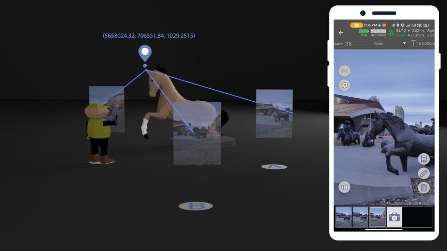
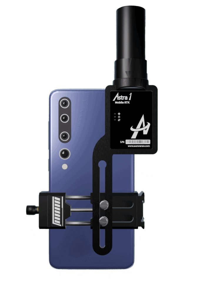
The small, light RTK receiver integrates the Anypos App and LoRa radio for high-precision surveying, photo surveys and 3D modeling.
Image: Aurora Navigation
Aurora Navigation has launched the Astra1 Mobile Visual RTK, a professional-grade GNSS receiver engineered to redefine high-precision mobile data acquisition.
The Astra1 is an ultra-compact (60g) solution designed to deliver reliable, centimeter-level positioning and advanced 3D mapping capabilities through seamless integration with a smartphone and the proprietary Anypos App.
The Astra1 Mobile Visual RTK is built to meet the demand for highly portable, yet exceptionally reliable, high-precision tools that simplify complex field operations.
Full Field Functionality. Users can perform standard surveying tasks, stakeout and RAW data capture directly from their mobile device.
Photo Survey. The system enables high-accuracy measurement of inaccessible or remote points, providing typical accuracy under 4 cm and significantly enhancing operator safety and efficiency.
Georeferenced 3D Scanning. Astra1 allows users to capture photos with precise RTK coordinates, enabling the creation of accurate 3D models for detailed construction verification and digital twinning applications.
Key Functional Features and Reliability:
Unmatched 60 grams and matchbox size
1408 channels, multiple frequencies
900MHz LoRa radio, compatible with Aurora Nav G1000 geodetic receiver
Accuracy: RTK 8mm+1PPM Horizontally, 15mm+1PPM Vertically, Photo survey <4 cm (2-15 m distance)
AI-enhanced reliability
IP67-rated
Mobile Visual Survey Workflow via the Anypos App, transforming a standard smartphone into a comprehensive high-precision data collector.
Image: Aurora Navigation
Industry applications and vision
Astra1 is a suitable and useful tool for professionals across multiple sectors:
Surveying & Engineering. Streamlines field stakeout and topographic data collection with minimal equipment.
UAV & Robotics. Serves as a lightweight PNT solution for GCP collection or base station for unmanned aerial vehicles (UAVs) and robotic platforms.
BIM/Digital Twin. Provides the foundational high-accuracy data required for complex 3D modeling projects.
“We designed Astra1 to address the fundamental need for portability, safety, speed, reliability and simplicity in professional geospatial data collection,” said Zhitao Lyu, founder and CEO, Aurora Navigation. “By focusing on superior performance in tough environments and integrating our Anypos App for a seamless visual workflow, we are delivering a tool that significantly boosts efficiency and safety, and provides survey-grade confidence to every user.”
Headquartered in Calgary, Canada, Aurora Navigation is focused on developing and delivering innovative GNSS solutions. The company is committed to advancing the efficiency and reliability of geospatial data collection through its unique blend of compact hardware design and advanced positioning algorithms.
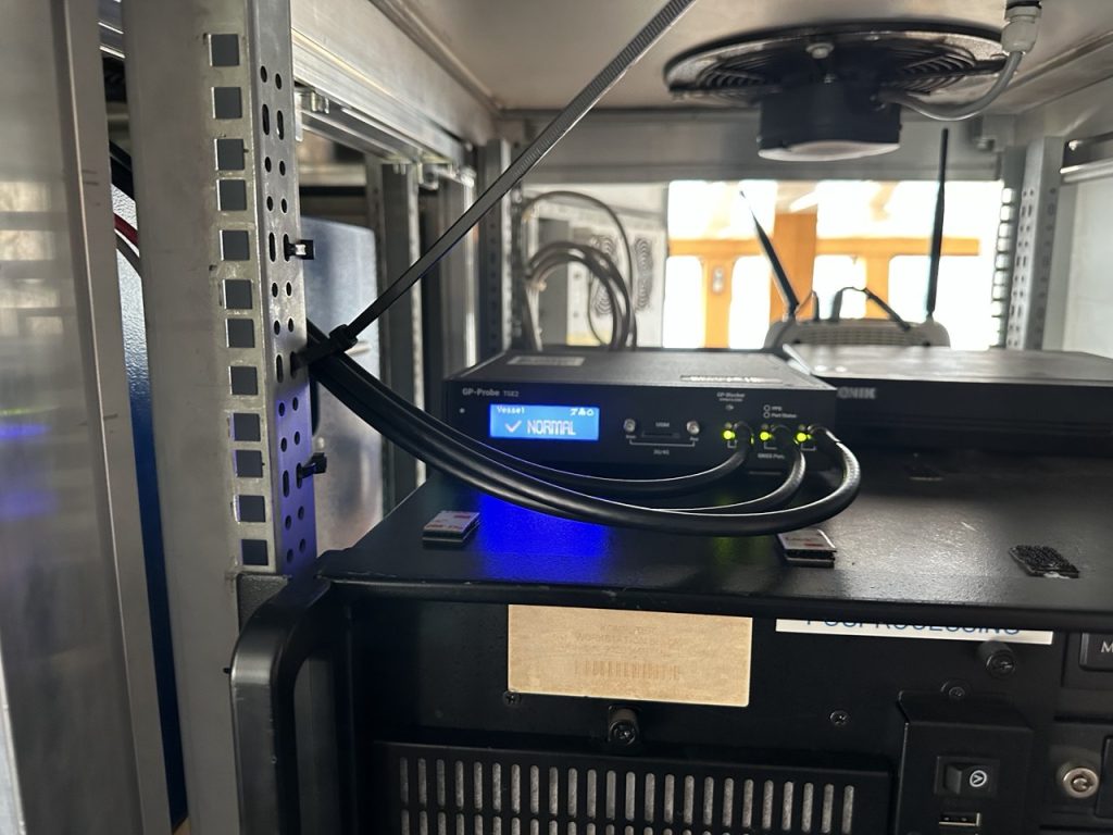
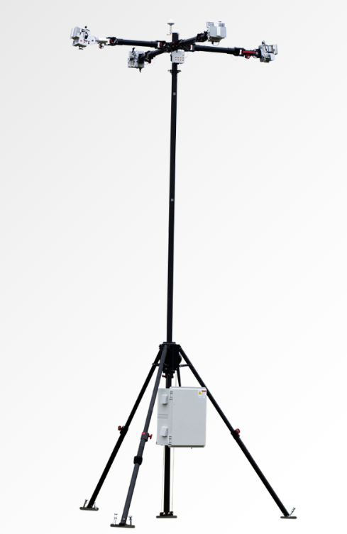
Shipborne Measurements Near the Kaliningrad Border
A major new report by GPSPATRON gathered data between June 23 and Oct. 14, aboard a vessel routinely leaving the Port of Gdańsk and performing extended maneuvers in open water.
The vessel conducted multiple offshore measurement campaigns, resulting in a shipborne dataset that provides a far more accurate representation of the true GNSS environment experienced by maritime operators in the Gulf of Gdańsk. It also reveals a level of interference complexity and intensity not visible in a previous coastal study.
In the present phase of research, the GPSPatron team moved beyond land-based monitoring and installed itsGP-Probe TGE2 interference sensor directly on board a research vessel. The ship operated throughout the southern Baltic Sea, including regular approaches toward the maritime boundary of the Kaliningrad region.
By placing the sensor on a moving platform rather than a coastal location, they were able to record GNSS interference exactly as it affects real vessels — capturing signal conditions that cannot be observed from shore due to differences in radio horizon, antenna orientation, multipath environment, and proximity to potential interference sources.
The GPSPATRON probe TGE2 instaslled within the vessel’s equipment. (Photo: GPSPATRON)
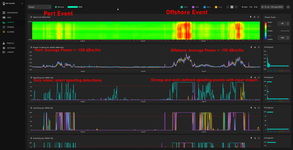
Transition from classical jamming to combined spoofing-jamming interference
In contrast to the previous six-month coastal study, where all recorded GNSS interference consisted exclusively of multi-constellation jamming, the current shipborne campaign reveals a fundamentally different interference landscape.
All major events now present a dual-layer structure composed of:
GPS L1 spoofing, generating forged satellite-like signals, and
Simultaneous jamming of GLONASS, Galileo, and BeiDou.
This combined architecture forces GNSS receivers to rely solely on spoofed GPS signals while denying access to independent ranging sources. The practice is consistent with commonly used operational strategies: spoofing only one constellation (GPS) drastically reduces system complexity and cost, whereas spoofing all GNSS systems would require multiple parallel RF chains, SDR-based generators, algorithms for signal simulations and amplifiers.
Highest recorded levels of GNSS disruption
The most severe interference period occurred from late June through July, during which:
GNSS availability dropped to 83.5%,
4 days, 5 hours and 24 minutes of spoofing were recorded — by far the highest cumulative spoofing activity of the entire campaign.
The single most extreme incident took place between 1 and 3 July, with nearly 30 consecutive hours of spoofing within a 48-hour interval, posing a severe risk for maritime navigation.
In subsequent months the interference intensity gradually decreased, yet low-power and short-duration events continued to be observed.
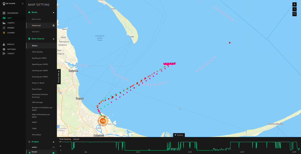
The area of the Baltic Sea the vessel patroled for GNSS interference. (Image: GPSPATRON)
A multi-emitter, synchronously operating interference network
Spectrogram analysis reveals that the interference does not originate from a single source but from four distinct, technologically different emitters operating in coordination:
The synchronous activation and termination of all four components indicate a centrally coordinated system, yet their differing spectral signatures, bandwidths, and stability levels confirm multiple spatially separated stations rather than a single unified installation.
This GNSS interference analysis shows interference intensity increases away from port. (Image: GPSPATRON)
Evolution of interference modulation techniques
A clear shift is observed compared to the previous study :
Previously, the dominant interference source consisted of a high-quality, purpose-engineered wideband signal with three clean constellation-matched components — an indication of modern, precisely designed jamming equipment.
In the current campaign, the prevailing interference is simpler wideband chirp jamming, a less advanced technique but deployed at significantly higher power levels.
The wideband analog-like component further shows pronounced parasitic frequency fluctuations, characteristic of older low-stability RF hardware.
This indicates a shift from high-precision jamming to a mixed environment of legacy high-power systems combined with newer spoofing capabilities.
Interference strongly intensifies offshore
A distinct spatial gradient was recorded:
In the Port of Gdańsk, interference appears weak or barely detectable.
As the vessel moves into open water, the same signals become up to 15 dB stronger.
The interference power consistently increases when approaching the waters facing Kaliningrad.
This pattern shows that — intentionally or not — the interference system affects maritime traffic far more than coastal infrastructure, with the operational impact being greatest in offshore navigational zones.
Download the full report using the form on this page.
Hoptroff, a precision timing specialist, has partnered with the London Stock Exchange (LSEG) through its Hosting & Connectivity Partner Platform, which enables financial markets customers to access third-party applications and services via LSEG’s global connectivity services.
The move reflects a fundamental shift in how financial services views timing infrastructure. No longer just a technical requirement, time has become a strategic investment in cybersecurity and digital resilience.
Timing precision has long been a regulatory necessity in financial markets. Rules such as MiFID II and FINRA CAT NMS define exactly how accurate trade timestamps must be. What’s changing is the expectation that timing infrastructure itself be resilient and independently verified.
Emerging EU and US guidelines now urge firms to mitigate over-reliance on GNSS/GPS and to implement terrestrial, traceable time sources that are protected against jamming, spoofing and cyberattacks. Time is under threat, and for financial institutions, dependable time is now a core element of regulatory resilience and audit confidence.
“Partnering with LSEG is significant,” said Tim Richards, CEO of Hoptroff. “As one of the world’s most influential financial institutions, their recognition of Hoptroff’s timing solutions demonstrates the strategic importance of resilient time that is easily accessible.”
Hoptroff combines precision timing with the reliability and uptime the sector demands, then pairs it with software that makes compliance straightforward. “Everything is plug-and-play, so firms get instant access without heavy upfront infrastructure costs,” Richards said.
Hoptroff addresses both established and emerging regulatory requirements for time synchronisation. The company holds ISO 27001 and ISO 9001 certifications and exceeds the precision standards financial markets require, offering accuracy across a terrestrial network that connects directly to national timing authorities, including NIST, NPL and RISE. This allows firms to meet global financial services regulations, such as MiFID II, FINRA CAT, and the EU Digital Operational Resilience Act (DORA), without sacrificing trading accuracy or uptime.
MatrixSpace has released the Portable 360 Radar, a rugged, easily transportable radar kit.
The Portable 360 Radar delivers reliable close-airspace awareness with panoramic coverage for rapid-response counter-drone operations, from safe-guarding stadiums and large public gatherings, to border security and battlespaces.
Traditional radar systems are cumbersome, slow to set up and limited in effectiveness for mobile C-UAS deployments, with high-power requirements. Instead, MatrixSpace Portable 360 Radar is low power, portable and affordable.
The MatrixSpace platform unifies threat awareness across multiple networked Portable 360 Radar systems and other sensors, without compromising local operation. By combining AI edge processing with MatrixSpace AiCloud Enterprise software, central command centers get an enhanced common operating picture and deep airspace activity analytics to assure public safety.
Major corporations and government agencies have adopted MatrixSpace Portable 360 Radar, which has excelled in rigorous C-UAS field testing including the U.S. Army’s recent xTechCounter Strike competition where it won best active sensor.
Key Features and Benefits
Low power, small footprint — a portable radar system easily transported by car that assembles in minutes.
Breakthrough affordability, enabling operators to catch hard-to-detect drones in challenging environments like dense cities and variable terrain.
Resilient AI edge-first architecture powered by sophisticated AI edge processing that continuously improves, assuring decisive operations even in congested environments.
Easy extensibility to MatrixSpace AiCloud — users can deploy one system or one hundred, all working together for enterprise command and control.
HERE Technologies has expanded its partnership with Precisely, a data integrity company, to provide accurate and reliable location intelligence for business use cases across industry sectors.
The partnership builds upon location intelligence capabilities within the Precisely Data Integrity Suite, giving companies deeper analysis, validation, and governance of their location data.
Through the partnership, HERE and Precisely use machine learning (ML) and artificial intelligence (AI) to collect and analyze location data, creating real-time updates that guide important business decisions like property management and analysis, among other business operations. The companies are working together to provide complete and accurate datasets to drive AI-powered intelligence for businesses.
The Precisely Data Integrity Suite delivers the trusted location intelligence that organizations need to power critical business decisions. The suite verifies, standardizes, and geocodes address data with high levels of accuracy and enriches it with robust contextual datasets. This combination of accuracy, consistency, and context helps businesses understand where things happen and why, enabling smarter risk assessment, optimized service delivery, and more targeted customer engagement. With governance and transparency built in, the Data Integrity Suite ensures location data is AI-ready and reliable for even the most regulated industries.
HERE’s Privacy Charter reinforces the company’s commitment to promote responsible privacy and security practices, including data minimization and anonymization. The company has a robust portfolio of certifications in security, privacy and cloud governance, including ISO 27001, SOC 2, TISAX, HITRUST r2, CSA STAR and ISO/IEC 42001, the first international standard specifically designed to guide organizations in managing AI systems responsibly.
New solution eliminates positioning errors in logistics, rail, and public safety by providing lane-level accuracy natively on rugged mobile devices.
Swift Navigation, a global leader in precise positioning technology, and RugGear, a manufacturer of rugged mobile devices for professional use, have joined to embed high-accuracy positioning capabilities into RugGear’s enterprise and mission-critical mobile devices.
The partnership integrates Swift Navigation’s Skylark Precise Positioning Service directly into RugGear devices built on the Qualcomm Snapdragon 6 Gen Platform. This native integration delivers reliable lane-level accuracy — an order of magnitude improvement over standard GPS — without requiring any external receiver or configuration. Precise positioning is available out of the box, ensuring seamless performance across rugged mobile form factors.
This integration is a major step in bringing high-accuracy positioning to industrial mobility. All location-based applications benefit automatically, meaning developers do not need to modify their existing apps.
Enhanced Capabilities with the RG940
The first device to integrate Skylark will be the RG940, a high-performance, rugged 10.1-inch tablet designed for demanding industrial uses. The high accuracy improves operational efficiency and accountability across enterprise segments, including:
Logistics and Waste Management. Optimizes routes, reduces fuel costs, and provides indisputable proof of service records for liability claims.
Construction. Provides a value-engineered approach for GIS mapping assets and enhances worker safety through geofenced “no-go” zones.
Rail. Enhances safety and efficiency for trains and prevents freight car loading errors.
Interested customers and partners are invited to contact RugGear directly for availability and technical specifications.