Kespry now offers a suite of capabilities that extends the value of aerial intelligence to the full life cycle of planning, bidding and managing earthworks projects in the major site construction industry.
The company is focused on making it easier to capture, process, use and share high-resolution information from the field with its fully autonomous aerial intelligence system.
Capabilities include grade planning and analysis, site and surface comparison including cut/fill visualization, and design plan development and compliance.
Compared to other drone mapping solutions, the earthworks-specific tools enable construction companies to more accurately plan the work, improve their cost structure, and deliver safer working environments through frequent analysis of changes to the site, according to Kespry.
The new capabilities are a result of customer and partner feedback, including from John Deere, dealers and clients.
The new earthworks capabilities provide:
Faster and more accurate production of earthwork grading plans through on-demand drone data capture and analysis. Mass haul plans can be easily developed before projects begin with an entire site mapped and analyzed in hours. New tools also enable haul road planning to support more efficient site planning.
Reduced costs for grading project bids, with project estimates delivered faster than with traditional estimating techniques. Ongoing operational costs are also reduced with on-demand cut/fill analysis enabling close management of the project and specific bid requests.
More efficient and safer project operations with progress comparisons delivered through daily drone flights. This enables design plan comparison through project plan overlay onto Kespry data, reducing the complexity and cost of rework. Safety can also be improved through close monitoring of change and analysis of grades around the site.
Col. Steve Whitney stands beside a statue of General Schriever at Los Angeles Air Force Base, home of the GPS Directorate. (Photo: U.S. Air Force/Joseph Juarez, Sr.)
By Col. Steven Whitney Director, Global Positioning Systems Directorate
The most discussed theme in the U.S. Air Force space community over the last year has been “resiliency.” But what does that actually mean, and how can the Air Force increase resiliency in space?
The GPS Directorate took these questions to heart and thought long and hard about resiliency in our Positioning, Navigation, and Timing (PNT) service. I am pleased to report that we have made significant progress in the past year in our quest to bring a new generation of PNT technology to reality.
More importantly, our investments in space, ground, and user equipment developments are bringing real, tangible benefits towards providing a more resilient PNT service worldwide. We stand on the cusp of delivering modernized civil and military GPS signals which provide critical pieces to the puzzle.
Farther into the future, the Air Force is already exploring new, emerging technologies and capabilities to even further advance the robustness of the GPS enterprise, with the vision that GPS will always remain the “Gold Standard” for the worldwide PNT community.
Resiliency Begins with Signals
Modernized GPS signals will be the first piece of the puzzle for an overall resilient PNT solution. The community has long anticipated the beginning of the multi-GNSS era.
The GPS Directorate has embraced this future with a new L1C signal, designed cooperatively from the ground up to be interoperable with international satellite navigation systems. The signal design will greatly improve GPS reception in cities and other challenging environments.
Another important GPS signal was introduced with our GPS IIF satellites. The L5 signal is designed specifically to meet the demanding requirements for safety-of-life transportation and other high-performance applications.
This signal is broadcast in a radio-frequency band reserved exclusively for aviation safety services to ensure it has optimal spectrum protection. Together, these two new additions greater improve PNT resilience for civil users around the globe.
“The need to improve cyber security and protection quite honestly cannot wait until delivery of the Next-Generation Operational Control System (OCX). To that end, the Directorate has focused on high payoff updates for the existing operational system.”
Other measures already improve resiliency by leveraging existing signals. For example, the L2C signal, when combined with L1 C/A in a dual-frequency receiver, will enable ionospheric error correction and improve positioning and timing accuracy.
For the military, the directorate has been focused on bring Military Code (M-code) into operations. The M-code signal features advanced anti-jam, anti-spoof, and encryption features that will ensure resilient and dependable PNT solutions for the United States and its allies.
The rollout of an operational M-code capability involves all segments of the GPS enterprise, and while it has been a long time in coming, the GPS Directorate made big strides this year (see “2017 in Review”). I will touch on the progress we are making in each of our development programs.
Resiliency in Space
The GPS space segment is the next step towards a more resilient PNT architecture. Our constellation remains robust and healthy, albeit aging, with 31 operational satellites providing worldwide coverage at the time of this article. The GPS III satellites will bring additional robustness with increased power and accuracy over previous generations of satellites.
We made big strides towards launching the first GPS III satellite in 2018, and just as importantly, production is in full swing on the rest of the ten satellites. I am incredibly proud of the entire government and contractor team that is meticulously acquiring, assembling, and testing these complex machines.
GPS IIIF. Farther into the future, the directorate is preparing for the GPS III follow-on program. The Air Force will be adding important new resiliency capabilities, with added signal flexibility via a reprogrammable, digital payload and increased anti-jam support to theater with a Regional Military Protection capability. Over the coming years as the follow-on GPS III satellites join the constellation, they will revolutionize GNSS with the full complement of operational L1C, L2C, L5 and M-code signals.
Resiliency in Control Segment
As important as the satellites are, the control segment is just as integral to the overall resiliency of the GPS enterprise. The need to improve cyber security and protection quite honestly cannot wait until delivery of the Next-Generation Operational Control System (OCX).
To that end, the directorate has focused on high payoff updates for the existing operational system.
For example, we acquired and deployed software-based GPS monitor station receivers, known as Monitor Station Technology Improvement and Capability (MSTIC) receivers, to replace the aging fleet of existing monitor-station receivers.
The functionality and expandability of the MSTIC receiver design will facilitate adding further capabilities such as M-code signal monitoring, and even civil L1C, L2C, and L5 signal monitoring.
The GPS Directorate also deployed a new cybersecurity monitoring suite to enhance cyber defenses. This new suite is in operation today at the GPS Master Control Station (MCS).
Beyond just improving our cyber protection, the Air Force has also stepped out on several OCX off-ramps to support the launch and operation of the GPS III satellites and mitigate risk of further OCX delays.
The Contingency Operations (COps) program modifies the existing Operational Control System (OCS) to allow the first GPS III satellites to join the operational constellation. The Air Force also initiated a companion program, M-code Early Use (MCEU) to further update OCS to provide limited M-code operations.
Together, these two programs provide critical interim steps towards fielding a more resilient constellation.
The OCX program provides the ultimate cyber protection and assurance needed for the GPS enterprise. After emerging from program recertification this year, the program has focused heavily on improved software system engineering and embracing software industry best practices, such as adopting DevOps and greater software automation.
The program has even leveraged Amazon Web Services’ Gov’t Cloud capability to provide more responsive development and test environments. While the program has a long ways to go, the government and prime contractor, Raytheon, are committed to delivery to ensure a robust and secure ground infrastructure.
User Equipment: Final Piece
The final piece of the resiliency puzzle for military customers is our user equipment segment. The directorate has made big strides in delivering the first set of modernized receiver cards for the Military GPS User Equipment (MGUE) Increment 1 program.
These advanced cards will enable platforms across the U.S. Department of Defense to leverage the new M-code signal, providing a tremendous boost in both anti-jam and anti-spoof capability.
They will also provide the latest in cryptography to ensure secure, robust protection for the United States and its allies.
Down the road, the Department of Defense is evaluating additional capabilities and platforms for the MGUE Increment 2 program.
Currently envisioned to address precision guided munitions, space receivers, and a modernized handheld unit, the Increment 2 program will be laying out an acquisition plan in this coming year to further adoption of M-code signals throughout the military.
A consideration for the future of user equipment will be exploring processing multi-GNSS signals. While no decisions have been made, multi-GNSS could offer opportunities for even additional resiliency.
Final Thoughts
This is an exciting time for the GPS enterprise.
We stand on the cusp of a new generation of capabilities that will usher in a huge increase in PNT resiliency and robustness. I am astounded at the quality of work that is presented at the many GNSS and PNT conferences around the world, and it is both exciting and humbling to see the community continuing to innovate ways to increase accuracy, integrity, availability, continuity, and performance.
Likewise, I am honored to lead the men and women of the GPS Directorate as we strive to deliver on our commitments and find new, innovative ways to provide robust and resilient PNT to the world.
This dedicated team is poised and ready to lead us into the future, and we look forward to working with the entire community to continue delivering the GPS “Gold Standard” in space-based PNT.
Lockheed Martin’s GPS III clean room in Littleton, Colorado.
By Col. Steven Whitney Director, Global Positioning Systems Directorate
This year saw the GPS enterprise take big strides towards completing major acquisition and development milestones and overcoming significant program challenges.
As we close out the year, the GPS Directorate stands poised to launch the first GPS III satellite in 2018.
The GPS III prime contractor, Lockheed Martin, successfully placed GPS III Space Vehicle (SV) 01 into storage in late February. Following a comprehensive engineering review, SV-01 was determined to be Available For Launch in September.
Road to Launch. The GPS Directorate also kicked off its inaugural Road to Launch campaign this year, and the satellite recently completed a final factory mission readiness test in November. Just as importantly, production is in full swing on the remaining nine satellites with the SV-02 Available For Launch declaration expected early in 2018.
The GPS Directorate was also hard at work preparing the request for proposal (RPF) for a follow-on production contract that will add up to 22 additional GPS III satellites. As the U.S. Department of Defense (DoD) finalizes requirements for the program, we stand ready to release the RFP by the end of the year.
OCX. While the Next Generation Operational Control System (OCX) continued to be a focal point for the DoD, the program has made progress in 2017 following a program restructuring. OCX completed the first integrated live-satellite launch rehearsal with GPS III in August.
A fitting capstone to the year’s achievement was the long awaited delivery in November of the initial version of OCX, known as the Block 0, to support launch and checkout of GPS III satellites. But while these are encouraging signs, there is still a long road to delivery of the full suite of capabilities in 2022.
The Contingency Operations (COps) program remained on track this year for delivery in 2019 to support interim GPS III operations. The program completed two (out of three) major software builds this year. The U.S. Air Force initiated a companion program, M-Code Early Use (MCEU), to enable limited M-code operations. MCEU is on target to complete its Preliminary Design Review in November 2017.
MGUE. Early this year, our Military GPS User Equipment (MGUE) program achieved acquisition Milestone B, allowing it to enter the Engineering and Manufacturing Development phase.
Just as importantly, MGUE successfully completed two major risk-reduction events. First, the U.S. Army successfully demonstrated 81-mm mortar precision-guided munitions integrated with MGUE receiver cards to complete the first ever M-code guide-to-hit tests in March.
The Air Force then demonstrated a prototype MGUE navigation unit integrated into the B-2 bomber in four successful flight tests. These tests are an important step towards anti-jam, anti-spoof GPS capability, ensuring secure, robust protection for the United States and its allies.
So, as we close this year, I am encouraged by our recent successes, but with a clear understanding of the many challenges ahead on the road to GPS modernization. We remain fully committed to meeting our program commitments with transparency.
DARPA’s OFFensive Swarm-Enabled Tactics (OFFSET) program envisions future small-unit infantry forces using small unmanned aircraft systems (UAS) or small unmanned ground systems (UGS) in swarms of 250 robots or more to accomplish diverse missions in complex urban environments.
By leveraging and combining emerging technologies in swarm autonomy and human-swarm teaming, the program seeks to enable rapid development and deployment of breakthrough capabilities to the field.
DARPA has awarded Phase 1 contracts to teams led by Raytheon BBN Technologies and Northrop Grumman Corporation.
Image: DARPA
Swarm Tactics. Both teams will serve as a swarm systems integrators tasked with designing, developing and deploying an open architecture for swarm technologies in physical and virtual environments.
Each system would include an extensible game-based architecture to enable design and integration of swarm tactics, a swarm tactics exchange to foster community interaction, immersive interfaces for collaboration among teams of humans and swarm systems, and a physical testbed to validate developed capabilities.
The teams will be responsible for experimentation and systems-integration efforts for realizing swarm capabilities, including producing tactics and technologies to test on its respective architecture.
Swarm Sprints. DARPA also aims to engage with a wider developer and user audience through rapid technology-development and integration efforts called swarm sprints. Participants in these experiments — sprinters — can work with one or both integration teams and each other to create and test their own novel swarm tactics and enabling technologies.
Roughly every six months, DARPA plans to solicit proposals from potential sprinters, with each swarm sprint focusing on one of five thrust areas: swarm tactics, swarm autonomy, human-swarm teaming, virtual environment and physical testbed.
The end of each sprint would coincide with physical and virtual capability-based experiments designed to test and assess integration of the thrust-specific OFFSET technologies. The experiments would also provide direct engagement between DARPA, the teams and sprinters, and warfighters who could help further tailor OFFSET capabilities to meet real-world operational needs.
“The swarm sprints are empirical experiments designed to accelerate our understanding of what swarms can do in urban environments,” said Timothy Chung, program manager in DARPA’s Tactical Technology Office. “By having swarm sprints at regular intervals, we’re able to ensure that we’re keeping up with the latest technologies — and are in fact helping inform and advance those technologies — to better suit the needs of the OFFSET program. Given the wide range of capabilities that we’re interested in, we’re looking for wherever those innovative solutions are going to come from, whether they be small businesses, academic institutions or large corporations.”
The U.S. Army is soliciting proposals for research, development, design and testing that directly supports battlefield technologies in the area of positioning, navigation and timing (PNT).
Broad Agency Announcement (BAA W56KGU-18-R-PN22) was issued by the U.S. Army’s Communications-Electronics Research, Development and Engineering Center (CERDEC) on Nov. 24 through FedBizOpps.gov.
CERDEC — based at the Aberdeen Proving Ground in Maryland — aims to discover technical approaches to improve and enhance current and future land warrior capabilities, flexibility and responsiveness in line with its strategic vision for enhancing warfighter capabilities to operate in both symmetric and unsymmetrical environments.
GPS-denied environments. “The goal is to support CERDECs Strategic Thrust for PNT by providing technical and operational capabilities that enables the soldier to continue their operations in hostile RF and GPS-denied environments,” reads the BAA. “Proposed technical approaches may apply to operations both before and after the cessation of hostilities.
“This announcement emphasizes approaches that address the very different challenges presented by urban fighting and dramatically enhance warfighter capabilities, for example, the ability to interact, maneuver and operate under a time constrained environment. These changes should generally result in lower casualties, lower collateral damage, and the effective use of combat power.
“The specific topics of interest revolve around the research and development of technologies may provide revolutionary improvements to the entire spectrum of PNT.”
Soldiers with 18th Military Police Brigade, assault opposing enemy threats during an Urban Operations training at the 7th Army Training Command’s Grafenwoehr Training Area, Germany, Oct. 20, 2017. (U.S. Army photo by Spc. Javon Spence)
CERDEC’s plan is to support multiple and potentially multiphase efforts that pursue the design, development, integration and demonstration of critical and enabling technology and system attributes pertaining to PNT. Proposed efforts will primarily be of service and material with aims at resolving technical barriers.
Proposals. Proposals submitted should range in scope from study and analysis type work with limited data and deliverables, to larger efforts for component developments, techniques and demonstrations with breadboard or prototype-style deliverables.
The contracts are expected to be cost-plus-fixed-fee, but can be negotiated.
Esri has entered into an enterprise agreement with the intelligence program line of Airbus Defence and Space. With this new agreement in place, the core GIS will be expanded to meet Airbus’s pivotal mission of using creativity and innovation to address the massive economic, social, and environmental challenges our planet faces.
The enterprise agreement is global in nature and includes all Airbus Defence and Space intelligence affiliates. The agreement also includes several addendums to cover the complete use of Esri’s ArcGIS platform by Airbus Defence and Space.
Airbus Defence and Space has used Esri technology as part of its GIS for 26 years.
“The potential of this agreement can be expected to reach far beyond today’s use of the Airbus Defence and Space core geographic information systems,” says Greg Buckman, head of Airbus Defence and Space’s intelligence business activities in North America. “Enterprise-wide access to the ArcGIS platform will provide new and faster spatial analytical functionality through web services to support key Airbus initiatives. This bears the potential for significant cost savings and speed to market while enhancing crucial cross-domain functionality on a global basis.”
“Esri shares in this vision and looks forward to supporting Airbus Defence and Space through the deployment of ArcGIS Enterprise,” said Lawrie Jordan, Esri’s director of imagery and remote sensing. “Having a complete GIS platform is vital to organizations such as Airbus Defence and Space that operate on a global scale and for whom geographic awareness is crucial.”
To learn more about how Esri helps the intelligence community make the most of location data with The Science of Where, visit go.esri.com/arcgis-intel.
Mitigating intentional interference for satellites is addressed in a new white paper released by Intelsat General.
The white paper details interference mitigation on the Intelsat EpicNG platform. Intelsat General is a wholly owned subsidiary of Intelsat and operator of the worldwide Globalized Network.
The whitepaper validates the ability of the Intelsat EpicNG platform to mitigate attempts by adversaries to intentionally interfere with signals operating on Intelsat’s multi-spot, high-frequency reuse, high-throughput satellites. This is particularly important for U.S. and allied military forces in hostile theaters throughout the globe.
“U.S. DoD (Department of Defense) satellite communication systems are critical for collecting and disseminating video and data that give the military real-time information about a hostile environment,” said Skot Butler, president of Intelsat General. “Our Interference Resolution demonstration showcases the capability of the Intelsat EpicNG system, and its advanced digital payload, to work around efforts to interfere or jam the signals being transmitted via our satellites.”
https://youtu.be/B0rhVk4MYY0
Demonstration. The Interference Resolution demonstration used a remote terminal transmitting video to a hub Earth station over the Intelsat 29e satellite. During the validation process, technicians transmitted an interference signal on the same channel used to transmit the video.
Once the interference was detected, technicians were able to reconfigure the satellite and the remote terminal, thereby re-establishing video transmissions. The reconfigurations
terminated the interferer at the satellite thereby clearing the downlink,
provided a new, interference-free uplink channel, and
connected the new video uplink channel to the original, now clear, downlink channel.
Intelsat 29e, launched in January 2016, was the first of Intelsat’s fleet of high-throughput satellites. Five Intelsat EpicNG satellites are now in orbit with one more planned for launch in 2018.
A Riegl VZ-6000 laser scanner, operating at 1064 um wavelength, serves as the backbone of the ATLAS system.
Leigh Stearns, a geologist with the University of Kansas, is working with a Riegl VZ-6000 ultra long range terrestrial laser scanner, incorporated into an ATLAS (Autonomous Terrestrial Laser Scanning) system, to monitor rates of ice loss on the Helheim Glacier, a tidewater glacier undergoing large-scale changes due to global climate change.
“Lidar is an emerging technology for the earth sciences because it produces an incredibly detailed 3-D view of features,” said the KU researcher. “Repeat lidar scanning reveals small-scale changes with very high precision. These systems are now used to measure how bridges are sagging, how tectonic faults propagate and now how glaciers flow. The ATLAS systems are unique because they’re designed to scan the glacier terminus every six hours, year-round. That’s not a trivial task when there’s no sunlight in the winter, winds are high and it’s very cold.”
The VZ-6000 high speed, high-resolution terrestrial 3D laser scanner offers an extremely long measurement range of more than 6000 meters for topographic (static) applications. Due to its laser wavelength, it is exceptionally well suited for measuring snowy and icy terrain in glacier mapping and monitoring applications in mountainous regions.
Learn more about the project at the University of Kansas website.
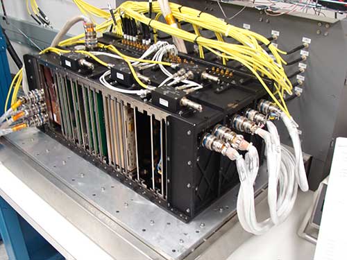
The fully digital Mission Data Unit (MDU) will create precise civil and military timing navigation signals for GPS III satellites 11 and beyond. Pictured here is the advanced MDU on navigation payloads being delivered for GPS III Space Vehicles 1-10. (Photo: Harris)
Harris Corporation has completed development of its fully digital Mission Data Unit (MDU), which is at the heart of its navigation payload for Lockheed Martin’s GPS III satellites 11 and beyond.
Harris has already provided MDUs and payloads for the first 10 GPS III satellites, one of which has been declared “available for launch” and the second of which is completing its testing. The other eight are in various stages of production assembly.
Payloads for the satellites 11 and beyond bring further signal transmit capabilities, providing more powerful signals and built-in flexibility to adapt to advances in GPS technology, as well as future changes in mission needs.
The new MDU that will eventually go aboard satellites 11+ “can be upgraded incrementally over its mission life due to built-in adaptability,” according to a Harris spokesperson.
GPS OCX
The U.S. Air Force Space and Missile Systems Center has accepted delivery of the GPS Next Generation Operational Control System (GPS OCX) Launch and Checkout System (LCS) baseline from Raytheon Intelligence and Information Systems. Also known as Block 0, LCS demonstrated conformance through test and analysis with all contractual requirements. OCX Block 0 is the foundation for Raytheon’s future Block 1 and 2 delivery, slated for 2022.
LCS is a fully modernized cyber-secure ground system complete with the computing hardware, operations center workstations, and mission application software necessary to launch the first GPS III satellite into orbit and perform initial on-orbit testing.
Mission operators are now using LCS in the GPS III Mission Readiness Campaign. The ground system is performing as expected during the rehearsals and space vehicle checkout.
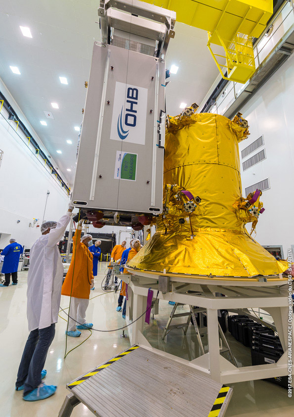
Galileo Launch
A Galileo satellite undergoes its fit-check validation at the Spaceport. Flight VA240. (Photo: ESA/Arianespace)
As this magazine goes to press, final preparations are underway for Galileo’s quadruple launch on Dec. 12. The Ariane 5 rocket has completed its build-up at the spaceport in French Guiana and is moving toward payload integration and rollout to the launch zone.
The four 700-kilo (1,543-pound) Full Operational Capability (FOC) Galileo satellites have completed checkout and one-by-one verification of their interfaces with the payload dispenser that will release them once aloft in mid-Earth orbit.
They will soon take on fuel for their long space life.
The satellites will bring the Galileo operating constellation to 22, and, according to the European Space Agency, this will provide availability to users anywhere in the world for a high-quality position solution — defined as position dilution of precision (PDOP) less than 5 — 99.8% of the time.
MODIS Image of Hurricane Harvey. This natural color image of Hurricane Harvey was acquired by the Moderate Resolution Imaging Spectroradiometer on NASA’s Terra satellite as the hurricane reached the Gulf Coast of Texas at 12:25 p.m. local time on Aug. 25, 2017. (Image: USGS)
Free and rapid imagery was provided through the USGS Hazard Data Distribution System.
The calls for assistance started days before Hurricane Harvey came barreling across America’s doorstep this summer. First responders and government officials needed answers to prepare and protect communities.
How strong is this storm going to be? What kind of damage occurred on its path through the Caribbean? How might it impact southeast Texas once it makes landfall?
Remotely sensed imagery was provided — at no cost and almost daily — through the U.S. Geological Survey’s (USGS) Hazard Data Distribution System (HDDS) for analysis on the extent, severity and evolution of hurricanes Harvey, Irma and Maria.
“USGS staff worked around the clock to keep HDDS populated with satellite and aerial imagery,” said Brenda Jones, who is the disaster response coordinator for the USGS Earth Resources Observation and Science Center (EROS).
15,000 images were downloaded from HDDS following the three storms. Requests came from 48 government agencies, including the U.S. Senate, Foreign Agricultural Service, Department of Homeland Security and the Centers for Disease Control and Prevention.
For example, Harvey dropped as much as 52 inches of rain in Houston. The Federal Emergency Management Agency used data from HDDS to identify roads and other infrastructure that were under water in an effort to better direct rescue efforts.
“Quick, easy and centralized access to high-quality imagery made it possible to create maps that were useful to disaster management authorities,” Jones said. “We haven’t had a hurricane season like this for a very long time, and the HDDS system proved invaluable to rescue efforts.”
In addition to hurricanes, HDDS is useful for numerous hazard situations. For example, following the recent earthquake near Mexico City, imagery provided through HDDS allowed first responders to see collapsed buildings, blocked roads and damaged infrastructure.
During fire season, HDDS makes it possible for first responders to have wide-scale pictures of situations.
HDDS acquires imagery and data from several sources, including the International Charter for Space and Major Disasters, of which the USGS is a member. Once the hurricane season began, USGS EROS staff began pulling data acquired by space and aerial systems and loading them into HDDS.
GEOS-13 Image of Hurricane Maria and Tropical Storm Jose. Image of Hurricane Maria and Tropical Storm Jose acquired by the Geostationary Operational Environmental Satellite 13 at 1:15 p.m. local time on Sept. 19, 2017. The satellite is operated by NOAA while NASA helps develop and launch the GOES series of satellites. (Image: USGS)
OnTerra Systems has introduced a new version of its MapSavvy aerial imagery service and a corresponding new website, www.MapSavvy.com.
MapSavvy is an affordable Web Map Service providing OGC-compliant images for anyone who needs aerial images in the course of their work or research.
The new version of MapSavvy offers users access to two versions of Bing Maps aerial imagery: original Bing Maps imagery and the recently updated aerial imagery updates introduced in 2017.
Typical users of MapSavvy are GIS and CAD professionals from business, research, or government organizations that need to use aerial imagery as part of projects, presentations, reports, or visual analysis of trends.
Examples of MapSavvy users include:
Architects and developers: Architects and developers use MapSavvy in GIS and CAD applications to obtain aerial imagery of construction sites to incorporate into projects, proposals and presentations that show where new buildings or structures would be located in the context of an existing built environment.
Research teams: Research teams use MapSavvy in GIS and CAD applications to access aerial imagery that will be incorporated into research reports, or to be able to spot trends by visually depicting information on top of an aerial image. MapSavvy is used for wildlife tracking, hydrology, environmental programs and a host of research activities.
Public safety: Law enforcement teams use MapSavvy to access base map where crimes are occurring, either to spot trends or to help solve a specific criminal case.
City planning: City planners use MapSavvy to see base map aerial views of cities, municipalities and unincorporated areas as part of their process of planning city infrastructure and new developments.
Oil and gas: Oil and gas companies use MapSavvy in GIS and CAD applications to view aerial imagery to plan for pipeline facilities placement.
The new MapSavvy aerial imagery service offers the flexibility of access to original Bing Maps imagery as well as the new updated aerial imagery introduced in 2017. The original Bing Maps imagery offers the highest resolution. The newly updated Bing Maps imagery offers the most up-to-date imagery of developed areas that have undergone changes to streets and buildings, or wild land areas that have seen changes due to geological shifts or wildfires.
“By offering MapSavvy users access to the original Bing Maps imagery and the new updated imagery, users get the best of both worlds,” said Steve Milroy, OnTerra Systems president. “This new version of MapSavvy lets users access original Bing Maps imagery if their application requires high-resolution images, or access recently updated Bing maps imagery if they require the most up-to-date images showing changes to cityscapes or wild lands.”
High-altitude pseudo-satellites (HAPS) are platforms that float or fly at high altitude like conventional aircraft but operate more like satellites. (Image: ESA Earth Observation Graphics Bureau)
The European Space Agency (ESA) is considering extending its activities to a new region of the sky via a novel type of aerial vehicle, a missing link between drones and satellites.
High-altitude pseudo-satellites, or HAPS, are platforms that float or fly at high altitude like conventional aircraft but operate more like satellites — except that rather than working from space, they can remain in position inside the atmosphere for weeks or even months, offering continuous coverage of the territory below.
The best working altitude is about 20 kilometers, above the clouds and jet streams, and 10 kilometers above commercial airliners, where wind speeds are low enough for them to hold position for long periods.
From such a height they can survey the ground to the horizon 500 km away, variously enabling precise monitoring and surveillance, high-bandwidth communications or back up to existing satellite navigation services.
Several ESA directorates have teamed up to investigate their potential, explains future-systems specialist Antonio Ciccolella.
“For Earth observation, they could provide prolonged high-resolution coverage for priority regions, while for navigation and telecoms they could shrink blind spots in coverage and combine wide bandwidth with negligible signal delay,” Ciccolella said.
“ESA is looking into how these various domains can be best brought together.”
“We’ve been looking into the concept for the last 20 years but now finally it’s becoming reality,” explained Earth observation specialist Thorsten Fehr.
“That’s come about through the maturing of key technologies: miniaturised avionics, high-performance solar cells, lightweight batteries and harness, miniaturisation of Earth observation sensors and high-bandwidth communication links that can deliver competitively priced services.”
Navigation engineer Roberto Prieto Cerdeira added, “There’s obvious potential for emergency response. They could also be employed semi-permanently, perhaps extending satnav coverage into high, narrow valleys and cities.”
The QinetiQ-designed and Airbus-owned Zephyr-7 solar-powered unmanned aircraft holds the world flight endurance record at 14 days. (Photo: Airbus)
European companies have already unveiled product lines. For instance, Airbus has developed the winged, solar-powered Zephyr, which in 2010 achieved a world record 14 days of continuous flight without refuelling.
The Zephyr-S is designed to fly payloads of a few tens of kilograms for up to three months at a time, with secondary batteries employed to keep it powered and aloft overnight. A larger Zephyr-T version now in preparation will support larger payloads and power needs.
The first flight is projected for 2021 for Thales Alenia Space’s Stratobus airship. (Artist’s rendering: Thales Alenia Space/Briot)
Meanwhile, Thales Alenia Space is preparing the lighter-than-air Stratobus, with its first flight expected in 2021.
The buoyant Stratobus airship can carry up to 250 kilograms, its electric engines flying against the breeze to hold itself in position, relying on fuel cells at night.
Many other firms are also developing vehicles, payloads and services. Last month saw them gathered at ESA’s inaugural workshop, together with representatives of potential customers, including the European Defence Agency, Frontex — the EU agency tasked with Europe’s border management — and EU Copernicus environmental monitoring services.
Airbus’s double-tailed Zephyr-T variant HAPS aircraft is designed to support larger payloads, keeping them aloft for months at a time. (Image: Airbus)
“This was the first meeting of its kind in Europe, with more than 200 HAPS experts” explains Juan Lizarraga Cubillos, from ESA’s telecoms area.
“We heard from them on the needs, opportunities and critical issues within the field, particularly as a complement for existing satellite services, to start preparing a future ESA programme.”
ESA regards the vehicles as a valuable way of establishing applications that complement its satellites while also accelerating space technologies through early, high-altitude flight testing.
The point was also made that market acceptance of HAPS would come down to their efficiency and cost-effectiveness — and the best way to show that would be through demonstration projects.
“We have to fly them,” remarked Alvaro Rodriquez of the EU’s Satellite Centre. “The technology is there, all the ingredients are there, now it’s time to mix them into a nice recipe.”
Thales Alenia Space’s Stratobus is topped with solar panels, powering its propellers to fly against the wind at 20 km for prolonged periods of service. (Image: Airbus)

 Kespry now offers a suite of capabilities that extends the value of aerial intelligence to the full life cycle of planning, bidding and managing earthworks projects in the major site construction industry.
 The new earthworks capabilities provide: