Author: Tracy Cozzens

  • 42 Technology and Omnisense collaborate on safer autonomous drone landing system

    42 Technology and Omnisense collaborate on safer autonomous drone landing system

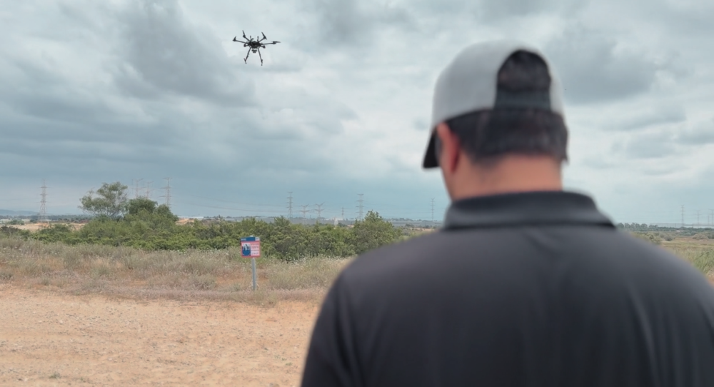
    42 Technology (42T) and Omnisense have demonstrated a safer autonomous drone landing system when GNSS signals are unreliable.

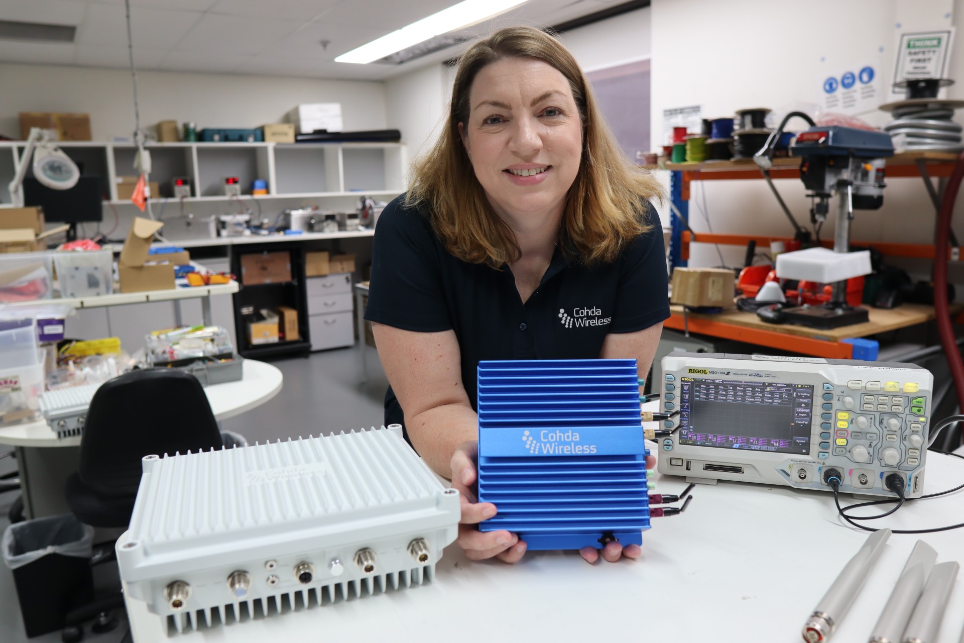
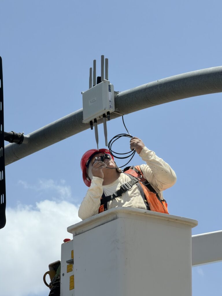
    The system uses a ground-based ultra-wideband (UWB) positioning technology. It was developed by Omnisense through its European Space Agency-supported DroneHome program.

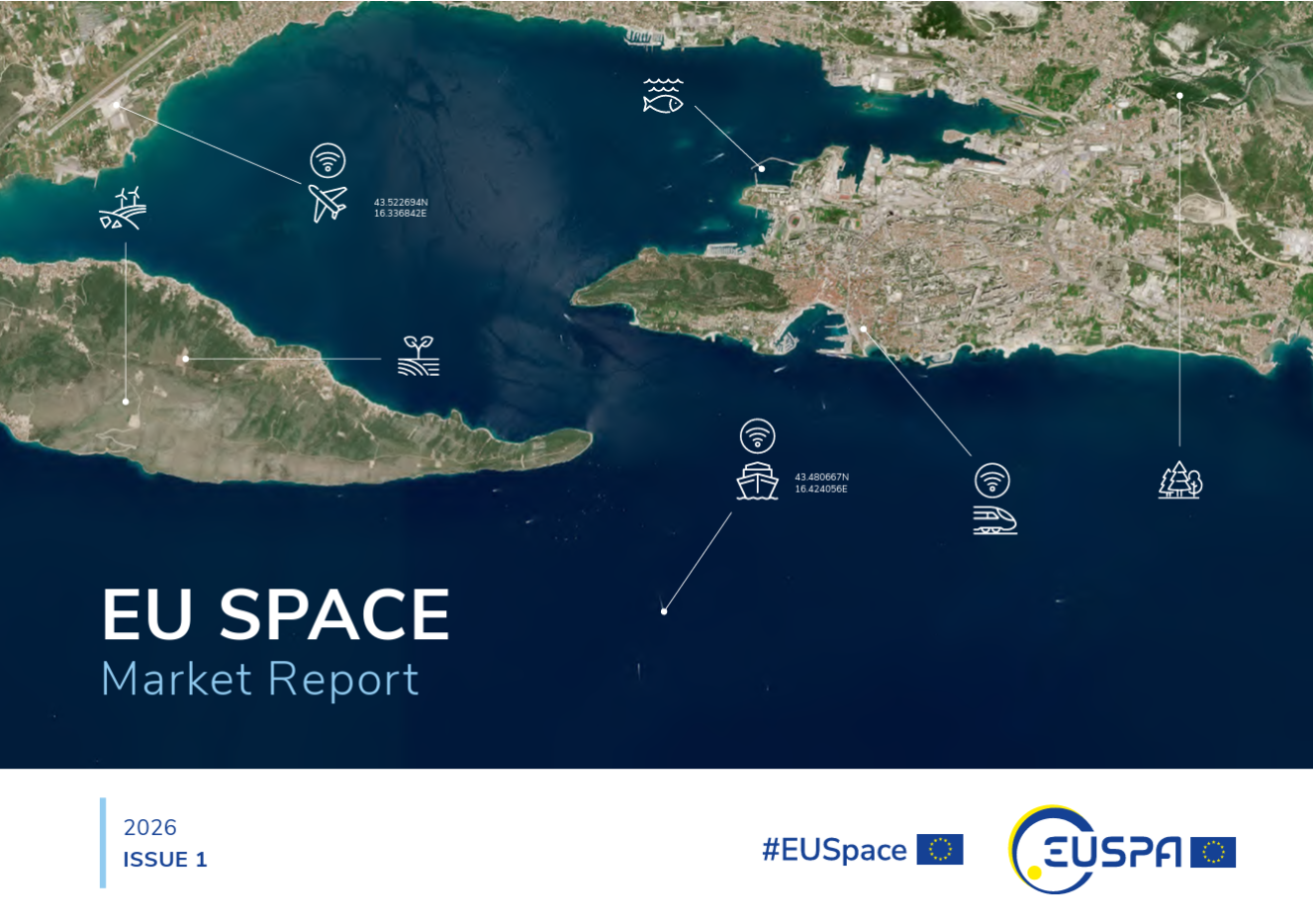
    Autonomous landing is a safety-critical phase for drone missions, particularly challenging when GNSS is impaired due to signal obstruction, reflection or interference (near tall buildings, in busy ports, or inside tunnels).

    The DroneHome program uses terrestrial radio positioning as a complementary navigation layer within the overall navigation system, so a drone’s position remains stable and predictable even in GNSS-challenged environments. In practice, this means autonomous systems can maintain controlled behavior instead of experiencing sudden navigation failures.

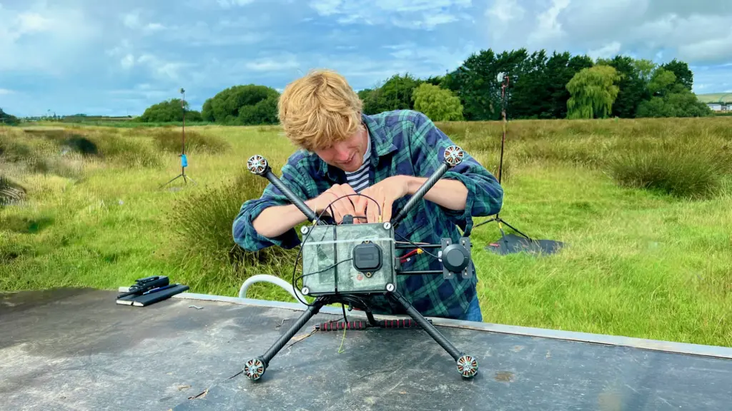
    One of the key technical challenges was extending the operational range of UWB positioning to make it viable for autonomous landing. 42T worked closely with Omnisense to design and develop the extended-range RF hardware used in both the ground infrastructure and airborne elements of the system. The front-end design incorporates a UWB system-on-chip with low noise amplification, power amplification, switching, and antenna integration to deliver the required range and performance.

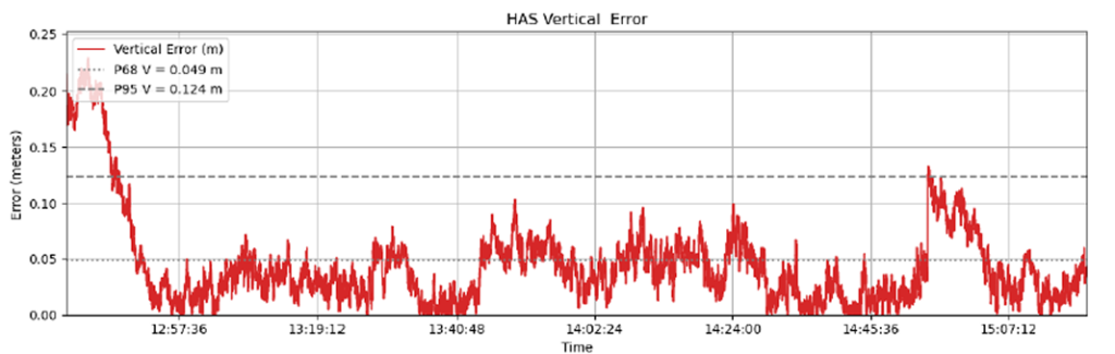
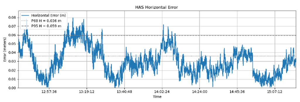
    Field trials and simulation-based analysis confirmed that the system maintained stable positioning within a defined envelope during GNSS-degraded operation, enabling reliable autonomous approach and landing.

    The results from Omnisense’s DroneHome program are directly relevant across a wide range of applications, including airborne, terrestrial and maritime operations, infrastructure inspection, and autonomous systems operating in GNSS-challenged environments.

    DroneHome was a focused development and validation programme exploring extended-range terrestrial positioning for autonomous navigation applications. The project was led by Omnisense in collaboration with Mozaero and supported by ESA under the NAVISP program.

  • Apogee awarded $103M PNT contract for US defense

    Apogee has been awarded a five-year, $103 million task order to provide positioning, navigation and timing (PNT) support services for the U.S. Department of Defense.

    The contract supports modernization, acquisition and sustainment planning across the international PNT enterprise, ensuring resilient and reliable capabilities that underpin critical military operations worldwide.

    Under the contract, Apogee will deliver technical expertise and mission support across multiple locations, including Robins Air Force Base, Georgia; Wright-Patterson Air Force Base, Ohio; and Eglin Air Force Base, Florida.

    Apogee’s team will contribute to advancing next-generation PNT capabilities, strengthening system performance and supporting the continued evolution of a mission essential to joint and coalition operations.

    Apogee is headquartered in Colorado Springs, Colorado, with regional offices nationwide.

  • UAS swarming project kicks off for Spanish Ministry of Defence

    UAS swarming project kicks off for Spanish Ministry of Defence

    UAV Navigation-Grupo Oesía and Alpha Unmanned Systems take on UAS swarming for Spain.

    The advanced guidance, navigation and control systems developed by UAV Navigation-Grupo Oesía, together with Alpha Unmanned Systems’ platforms, will be deployed in the FENIX project, which aims to consolidate capabilities in heterogeneous unmanned vehicle swarms.

    The project is framed within the COINCIDENTE Programme, the Spanish Ministry of Defence’s National R&D Plan, which seeks innovative technological solutions of interest for defense. It will also benefit from the support of institutions such as AICIA (Association for Research and Industrial Cooperation of Andalusia, University of Seville) and FADA-CATEC (Advanced Aerospace Technologies Centre).

    The main objective of FENIX is the design, development and validation through simulation and flight test campaigns of a technological demonstrator for an autonomous control and coordination system for heterogeneous unmanned aerial vehicle (UAV) swarms.

    The system will build on Alpha Unmanned Systems’ existing UAV platforms, as project lead, and on the advanced autopilot technology of UAV Navigation-Grupo Oesía. Building on this foundation, new technologies will be developed to endow the swarm with collective intelligence, in alignment with military doctrine. These technologies will analyze, assess and demonstrate how the use of such systems enhances effectiveness and efficiency in surveillance and reconnaissance tasks in complex and contested environments, while also providing increased robustness.

    Key developments and objectives of the project include:

    • Swarm coordination and planning system: Capability for efficient, real-time replanning in response to unforeseen events.
    • Cooperative perception system: Integration of multisensor data collected by the different UAVs, enhancing detection accuracy and robustness against occlusions, concealment and adverse weather conditions.
    • Advanced capabilities for critical missions: Identification and mapping of areas of interest under GNSS signal interference (jamming) or spoofing, as well as in NRBQ (CBRN) threat scenarios, and detection of specific targets in patrol, reconnaissance, target acquisition, and search-and-rescue missions.

    The use of a heterogeneous UAV swarm will enable these missions to be carried out more effectively and efficiently, directly enhancing defense operational capabilities. The FENIX system operator will only need to define the mission to be executed by the swarm through a single human–machine interface.

    The system will automatically decompose the mission defined by the operator into simple tasks, optimally allocate these tasks to the UAVs within the swarm according to their capabilities and constraints, and generate and assign safe, efficient and physically feasible trajectories for each UAV, while respecting kinematic constraints, energy limitations, communication range constraints, and other operational factors.

    The FENIX Project, supported by the advanced intelligence of UAV Navigation-Grupo Oesía’s GNC systems and Alpha Unmanned Systems’ rotary-wing platforms, represents a significant step forward in the use of UAV swarms for military applications. This project provides a robust and efficient tool for inspection and reconnaissance in complex and contested environments.

  • EUSPA launches new EU Space Market Report, strong GNSS growth predicted

    EUSPA launches new EU Space Market Report, strong GNSS growth predicted

    A new edition of the European Union’s Space Market Report is now available. According to the EU’s Agency for the Space Programme (EUSPA), it offers a comprehensive overview of the latest developments, emerging trends, and market dynamics shaping the global space downstream sector.

    The report provides a comprehensive overview of the latest developments and trends in GNSS, as well as Earth observation (EO), secure satellite communications (Secure SATCOM), and space situational awareness (SSA) in one place for the first time. It also highlights the evolution of user technologies and the growing synergies between these domains.

    “As Europe’s space capabilities become increasingly interconnected, it is essential to move beyond viewing them as standalone technologies,” explained Rodrigo da Costa, EUSPA executive director. The publication “reflects the growing synergies between these domains and their strategic importance for Europe’s economy, resilience and autonomy.

    “By providing a comprehensive view of the evolving space ecosystem, EUSPA aims to foster innovation, strengthen collaboration across the sector, and support the development of a more competitive, agile and responsive European Union space economy,” da Costa said.

    GNSS and EO

    The report highlights sustained growth for both the GNSS and EO markets across all 16 analyzed market segments. The current €3.5 billion of EO market revenue in 2024 is expected to grow to €7.9 billion by 2034 with agriculture representing the largest share.

    GNSS revenues are forecast to rise from €300 billion in 2024 to €580 billion by 2034. GNSS service revenues outpace device revenues and confirm the increasing role of digital ecosystems and value-added services in the space economy, the report said.

    Revenues are mainly driven by consumer solutions, and road and automotive, with a global installed base of GNSS-enabled devices that will reach almost 10 billion by 2034.

    Secure SATCOM

    The Secure SATCOM market addresses the needs of surveillance, key infrastructure and crisis management. In this sector, data service revenues generated by EU users are forecast to grow significantly, increasing from more than €200 million in 2025 to nearly €1.2 billion by 2040.

    While maritime surveillance drives demand in 2025, by 2040 the market is expected to be led by law enforcement interventions, civil protection and force deployment, fueled by growing security and resilience needs, demand for reliable connectivity, and stronger crisis-response capabilities.

    Existing and future synergies

    The report also examines how major macroeconomic trends —including climate change, geopolitical instability and rapid urbanization — are reshaping space markets and strengthening synergies between EO, GNSS and Secure SATCOM technologies. Together, these capabilities are becoming increasingly important for security, resilience, disaster response, environmental monitoring, and smarter urban and infrastructure management.

    Download the EU Space Market Report.

  • Cohda Wireless to support landmark V2X deployment in Arizona

    Cohda Wireless to support landmark V2X deployment in Arizona

    The Maricopa County (Arizona) Department of Transportation (MCDOT) has selected connected-vehicle technology specialist Cohda Wireless to support delivery of its Connected Vehicle
    Acceleration Zone (CVAZ).

    The CVAZ is a USDOT-backed deployment designed to accelerate interoperable vehicle-to-everything (V2X) technology across key corridors in the county. CVAZ forms part of the Federal Highway Administration’s “Saving Lives with Connectivity: Accelerating V2X Deployment” program, which is supporting national models for connected vehicle deployment in Arizona, Texas and Utah.

    The Maricopa County project will rely primarily on 5.9 GHz
    communications and is expected to connect up to 750 physical and virtual roadside units with 400 onboard units across transit, emergency response and freight fleets.

    The deployment will support emergency vehicle pre-emption, vulnerable road user alerts, transit signal priority and freight signal priority in Phoenix, Tolleson, Avondale and unincorporated Maricopa County, as well as along ADOT’s US 60 highway.

    Together, these applications are intended to help emergency vehicles move more efficiently through intersections, improve transit reliability, reduce freight delays and provide earlier warnings around pedestrians and cyclists.

    Following its selection as a vendor, Cohda is contributing technical expertise in testing and deployment planning to support delivery of the CVAZ application zones. Under the project, Cohda will supply MK6 Road-Side Unit (RSU) kits and MK6 On-Board Unit (OBU) kits across the CVAZ application zones.

    The program is designed as a multi-vendor deployment. Cohda’s RSU and OBU platforms are positioned to integrate with the county’s selected roadside processing environment, helping reduce integration risk and support faster deployment.

  • Norway placing more monitoring stations to measure Russian GNSS interference

    Norway placing more monitoring stations to measure Russian GNSS interference

    For Norway, frequent GNSS jamming and spoofing is affecting a wide range of civilian operations, including air traffic. Interference is increasingly being detected deeper inside Norwegian airspace, reports the Barents Observer.

    Three dedicated monitoring stations for detecting GNSS disturbances have already been established in the region bordering Russia. Now, the Norwegian Communications Authority (Nkom) plans to install two additional stations this year.

    The new sensors will provide improved continuous monitoring, covering key new areas, including large parts of the Varanger Peninsula and the Barents Sea.

  • Taoglas introduces ultra-compact dual-band high-precision GNSS antenna

    Taoglas introduces ultra-compact dual-band high-precision GNSS antenna

    Taoglas has launched the GVLB208 series, an active and passive dual-band GNSS L1/L5 stacked patch antenna — the first in a new family of ultra-compact antennas.

    Combining a tiny package with concurrent L1/L5 support and stable right-hand circular polarization (RHCP), the antennas deliver reliable centimeter-level positioning in a compact 20 x 20 x 8 mm footprint.

    The GVLB208 series is designed for applications that require high-precision positioning in a compact form factor. Its size, dual-band support and circular polarization make it suitable for designers looking to improve positioning performance without increasing device footprint.

    The new antennas address this challenge with a single-feed stacked patch design that supports concurrent L1 and L5 GNSS bands. By leveraging dual-band operation, they significantly reduce the impact of multipath interference, enabling more reliable positioning and improved accuracy in complex RF environments.

    The series delivers dual-band L1/L5 performance typically associated with larger GNSS patch antennas. The antenna achieves peak gain of up to 1.5 dBi, approximately 50% efficiency across both bands, and an axial ratio of around 4 dB, supporting stable RHCP signal reception and consistent positioning performance.

    Optimized for major global GNSS constellations, including GPS, Galileo, GLONASS and BeiDou, the GVLB208 series supports reliable operation across varied RF environments.

    • The passive GVLB208 A single-feed architecture enables dual-band L1/L5 performance without the complexity of multi-feed designs, while its pin-mount configuration simplifies RF layout and integration. It can be easily implemented on standard PCB designs, with optimal performance achieved on a typical 70 x 70 mm ground plane.
    • The active AGVLB208.A, including active electronics and filters, is supplied with 1.13 micro-coax cable and an I-PEX MHF I connector for easy integration with the latest multiband GNSS modules.

    The GVLB208 series is suitable for autonomous delivery robots requiring seamless sidewalk navigation and precise drop-offs, where every centimeter counts. It also supports applications including unmanned aerial vehicles (UAVs), telematics systems, fleet and asset tracking, precision agriculture, and industrial IoT deployments.

    Taoglas plans to expand the GVLB208 family later this year with an active SMD variant with integrated active electronic components, designed for automated high-volume manufacturing.

  • EUSPA tests prove suitability of Galileo HAS for precision agriculture

    EUSPA tests prove suitability of Galileo HAS for precision agriculture

    The Galileo High Accuracy Service (HAS) was tested under real farming conditions to assess its performance and suitability for precision agriculture

    The European GNSS Service Centre (GSC) of the European Union Agency for the Space Programme (EUSPA) partnered with Hemisphere GNSS and Case New Holland to test the suitability of the Galileo HAS service for precision agriculture.

    The tests were performed at the New Holland campus in Peñarrubias del Pirón, Segovia, Spain.

    The working width used for the test was 2.55 m, while the test area covered approximately 20,000 m² with a perimeter of about 740 meters. During the three-hour test, the teams collected GNSS data to analyze the pass-to-pass and absolute accuracy metrics. Pass-to-pass accuracy is the relative precision of a guidance system to maintain a consistent distance between adjacent, parallel machine passes within a short timeframe (usually 15 minutes). It is crucial for reducing gaps and overlaps during planting, spraying, and harvesting.

    Test campaign

    The test campaign aimed at proving that the tractor consistently maintained the specified path accuracy during consecutive passes. This would show that HAS can optimize agricultural operations by reducing costs associated with overlaps (reworking the same area), leading to savings such as reduced fuel consumption, minimal input waste, and improved crop yield.

    For the test setup, in addition to the onboard guidance system, an independent antenna was mounted on the tractor cab. This antenna was connected to two positioning solutions: one based on the Galileo HAS and another based on an RTK solution.

    An RTK base station deployed for the occasion provided the rover with precise RTK corrections and enabled generating a “reference path” against which to compare the tested Galileo HAS, in this case based on corrections obtained directly from the signal in space (SIS) via the Galileo E6 band.

    The driving was performed in automatic mode, with manual intervention required only for turning at the end of each pass. The autosteering system of the tractor would then automatically reconnect with the following path, as calculated at start-up.

    Test results

    The test began with the GNSS receiver in Cold Start mode, requiring it to obtain ephemerides and process satellite data before achieving precise positioning. The convergence time was calculated and is shown as the red area in the image below. The green area shows when the tractor started along the predefined paths and hence when the data was used for the pass-to-pass accuracy calculation.

    Converge time and data set during the test. (Credit: EUSPA)
    Converge time and data set during the test. (Credit: EUSPA)

    The data analysis showed that the Galileo HAS system consistently maintained horizontal errors of 3-6 cm.

    With a 95% horizontal error of 5.9 cm and its maximum value below 8 cm, the error remains well below the 20 cm HAS accuracy target.

    As regards the vertical axis, the 95% vertical error was 12.4 cm, with its maximum value below 25 cm, (remaining well below the 40 cm HAS accuracy target).

    Galileo HAS signal vertical error. (Credit: EUSPA)
    Galileo HAS signal vertical error. (Credit: EUSPA)


    The horizontal error of the HAS service relative to the RTK reference baseline is shown in the following figure.

    Galileo HAS signal horizontal error. (Credit: EUSPA)
    Galileo HAS signal horizontal error. (Credit: EUSPA)

    Regarding the pass-to-pass accuracy, the analysis shows an overall pass-to-pass accuracy of 1.18 cm, demonstrating highly stable performance throughout the test period.

    Year-to-Year accuracy was not part of this testing campaign but will be analysed in the next testing campaign.

    Galileo HAS potential confirmed

    The Galileo HAS service is an open, standardized correction service distributed directly via Galileo E6 or the internet (with global coverage) and the test campaign results confirm its potential to generate savings to farmers in terms of fuel consumption, fertilizers, seeds and other inputs, by reducing overlap in field operations.

  • As GNSS disruptions rise, infiniDome moves toward mission continuity

    As GNSS disruptions rise, infiniDome moves toward mission continuity

    The rapid growth of autonomous military systems is creating a new challenge for the defense industry, working to keep equipment operating when navigation becomes unreliable.

    Across recent conflict zones and contested regions, GNSS disruption is affecting UAVs, loitering munitions, ISR platforms, maritime systems and autonomous ground vehicles.

    At the upcoming International Drone Show, infiniDome will present what it describes as an evolution of its vision.

    “InfiniDome is expanding its vision beyond GNSS protection, toward a future of mission continuity and navigation awareness in contested environments,” the company stated.

    The statement reflects a broader trend across the defense autonomy sector. While anti-jamming technologies were once treated primarily as protective add-ons, many military programs are now integrating navigation resiliency into wider autonomy architectures. The result is a growing shift in how autonomous systems are evaluated.

    Rather than focusing solely on navigation accuracy or platform performance, defense organizations are increasingly asking whether autonomous systems can maintain operational continuity under degraded or denied conditions. Industry observers note that this transition is particularly evident in the loitering munition and tactical UAV sectors, where survivability in contested environments is becoming a baseline operational requirement.

    At the same time, low-SWaP anti-jamming capabilities are becoming more common across the market, increasing pressure on companies to differentiate beyond hardware alone.
    That pressure appears to be accelerating a broader industry movement toward what some describe as “navigation awareness,” the ability not only to withstand interference, but also to understand and react to the electromagnetic environment in real time.

    International Drone Show demonstration

    The International Drone Show takes place June 3-4 in Odense, Denmark.

    InfiniDome is expected to demonstrate this direction during the exhibition through IroNav, developed jointly with Wonder Robotics. The demonstration will include autonomous operation streamed live from a jammed environment in Israel, showcasing navigation resilience capabilities under active interference conditions.

    The live demonstration comes as European defense programs continue increasing investments in autonomy, tactical drones, and resilient battlefield systems amid growing concerns surrounding electronic warfare and GNSS vulnerability.

  • Septentrio unveils mosaic-G5 P8, ultra-resilient GNSS module

    Septentrio unveils mosaic-G5 P8, ultra-resilient GNSS module

    Septentrio, part of Hexagon, has announced the launch of the mosaic-G5 P8 receiver. The multi-frequency module, measuring 23 mm by 16 mm and weighing 2.2 grams, enables accurate and resilient positioning without any performance compromises for mission-critical devices, UAVs, marine vessels, and rail applications.

    Built for reliable operation in contested GNSS environments,  AIM+ Ultimate technology protects the receiver from powerful and sophisticated GNSS jamming and spoofing attacks. It delivers comprehensive situational awareness, combining timely interference and spoofing indicators with detailed power and frequency data, which can help localize jammers.  

    “The mosaic-G5 P8 is in a class of its own: uncompromised GNSS resilience in a secure, ultra‑compact, all‑in‑one design,” said Yasmine Hunter, product manager at Septentrio.

    The newly released module features an integrity-focused design that ensures truthful positioning and reporting, enabling the system to quickly switch to other sensors during GNSS disruptions in heavily compromised environments. Secure communication with input and output authentication prevents unauthorized access and data interception. mosaic-G5 P8 also offers high update rate with low latency, supporting reliable navigation and control in highly dynamic applications.

    The module is compatible with widely used, open-source autopilots like PX4 and ArduPilot, simplifying drone integration. The mosaic-G5 P8 evaluation kit, featuring direct autopilot connections, is available for testing and prototyping, and the RxTools user interface streamlines setup and evaluation.

    Meet Septentrio’s GNSS experts and mosaic-G5 P8 during SOF Week in Tampa, Florida, May 18–21, in booth #609.

  • Shipping industry provides guidance on traveling through Strait of Hormuz

    Shipping industry provides guidance on traveling through Strait of Hormuz

    In a move to enhance maritime security and operational safety, global maritime organization have released on May 20 new guidance for ships transiting the Strait of Hormuz, reports Shipping Telegraph.

    The 22-page guidance document — “Industry Guidance on the Safe Management of Vessel Transit through the Strait of Hormuz” — aims to assist in planning and safely managing vessel transits into, within or out of the Gulf region during periods of heightened regional security risk.

    The document was issued jointly by major industry organisations including International Chamber of Shipping (ICS), BIMCO, Intercargo, Intertanko, IMCA and OCIMF

    Vessels may face a high workload and high-stress operating environment, including GNSS jamming or spoofing.

  • TrustPoint secures USSF contract to demonstrate GPS-independent PNT

    TrustPoint has been awarded a $4 million Tactical Funding Increase (TACFI) contract to demonstrate a GPS-independent positioning, navigation and timing (PNT) system.

    The award was issued by SpaceWERX, the innovation arm of the United States Space Force, and jointly funded by the Small Business Innovation Research (SBIR) program and the Commercial Space Office (COMSO). It supports a full end-to-end demonstration of TrustPoint’s resilient navigation architecture designed for defense and commercial applications.

    Under the contract, TrustPoint will design, deploy and operate a fully integrated PNT system comprising four satellites and four ground stations, delivering a complete operational architecture. The program will execute an end-to-end system demonstration, including live trilateration across multiple space and ground assets, operational services and advanced receivers.

    With an accelerated execution timeline, initial system deployments will occur within 12 months, establishing a rapid deployment model designed to scale to significantly larger constellations while prioritizing affordability, operational relevance, and capital efficiency.

    “We founded TrustPoint on the belief that resilient navigation does not require billion-dollar constellations,” said Patrick Shannon, founder and CEO of TrustPoint. “This program will prove our technology’s GPS independence while demonstrating that real, operational PNT capability can be delivered with exceptional capital efficiency.”

    Beyond GPS-independent C-band demonstrations, the system will validate a software-defined architecture that supports on-demand reconfiguration of navigation services in contested, degraded and denied environments, pioneering commercial delivery of this capability. TrustPoint’s experience includes the first C-band GNSS signal transmission with real-time reception and the first broadcast-based ground-to-space C-band PNT demonstration.

    The program directly advances national security objectives. It also establishes a scalable foundation for future commercial services, redefining what is possible for users who require reliable PNT in GPS-challenged environments.