Author: Tracy Cozzens

  • Latest Galileo satellites join constellation with enhanced, faster fix

    Latest Galileo satellites join constellation with enhanced, faster fix

    Galileo launch 11 from Europe’s spaceport in French Guyana. (Photo: ESA/CNES/Arianespace)
    Galileo launch 11 from Europe’s spaceport in French Guyana sent satellites 27 and 28 into orbit. (Photo: ESA/CNES/Arianespace)

    News from the European Space Agency (ESA)

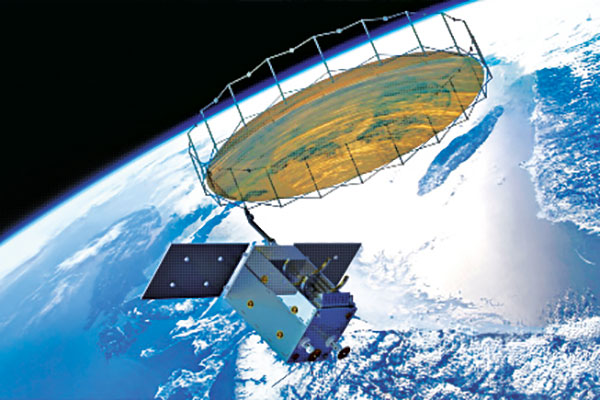
    Europe’s latest Galileo satellites in space have joined the operational constellation, transmitting navigation signals to three billion users across Earth as well as relaying distress calls to rescuers.

    Their entry into service follows a summer test campaign and will result in a measurable increase in positioning accuracy and improved data delivery performance of the overall Galileo system.

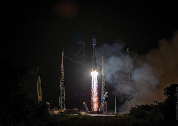
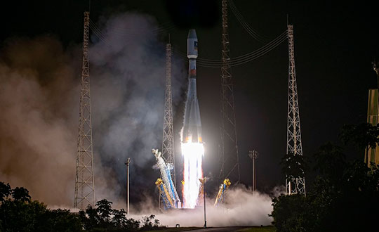
    Galileo satellites 27-28 were launched at the end of 2021 and underwent in-orbit test review at the end of April. The review was conducted by ESA, satellite manufacturer OHB, and navigation payload maker Surrey Satellite Technology Ltd (SSTL).

    Key findings showed both satellites’ payloads are performing extremely well — among the best in the entire constellation — and the satellites entering into service increase the position accuracy and robustness of the overall Galileo system.

    A successful system and in-orbit operations review followed, co-chaired by ESA and the EU Agency for the Space Programme (EUSPA), which is in overall charge of commissioning.

    Improved navigation message

    The two satellites are the first to broadcast an improved navigation message, resulting in three key improvements for Galileo’s public Open Service users:

    • faster navigation data acquisition, allowing users to establish a first position fix more rapidly
    • better robustness in challenging environments, such as urban centers
    • easier access to timing information in the navigation message for users possessing only a rough estimate of timing of the order of 1-2 seconds.

    For the testing and broadcasting of this new navigation message, new software for the Navigation Signal Generation Unit was developed by Thales Alenia Space in Italy, SSTL, OHB and ESA, and was uploaded to the two satellites.

    During the summer, an extensive test campaign was conducted by ESA to ensure the compatibility of the entire Galileo system at unit, payload, satellite, ground and system levels with the enhanced message. As part of this effort, EUSPA oversaw receiver testing to ensure this compatibility extended to Galileo receivers and chipsets in the market.

    These latest launched satellites made ideal test cases for the software and the improved navigation message. Transmission of the upgraded signals from Galileo satellites 27-28 allowed the team to confirm its correct implementation and characterize its long-term performance.

    Following a successful Test Review Board, the satellites were brought back into service on Aug. 29

  • Carlson joins with Autel on professional UAS package

    Carlson joins with Autel on professional UAS package

    The Autel EVO II Pro RTK UAS. (Photo: Autel Robotics)
    The Autel EVO II Pro RTK UAS. (Photo: Autel Robotics)

    Carlson Software and Autel Robotics are partnering on the Autel EVO II Pro Series drone to provide drone operators with the opportunity to use the full suite of Carlson’s software and hardware solutions.

    “We can take you through the entire project lifecycle, from setting your ground control points with a BRx7 GNSS receiver and RT4 data collector with SurvPC field software to the actual drone flight to the photo processing on your computer or in the cloud, all the way through to processing that data, creating linework, surfaces, and finished plans in CAD with our powerful, industry-standard office software,” said Derek Roché, Carlson regional manager.

    Carlson’s tools for UAS professionals include:

    • Carlson PhotoCapture, a standalone or cloud-based photogrammetry software to create point clouds, orthoimages, surfaces and more from drone photo data
    • Carlson Point Cloud office software, which provides powerful tools such as bare-earth and automated feature extraction for point clouds
    • Carlson’s suite of CAD office software, including the Carlson Survey program to create finished CAD files and plans
    • Carlson BRx7 GNSS receiver, which can be used both to accurately place ground-control points and as a base to provide corrections to an Autel EVO II Pro RTK drone through Carlson’s Listen-Listen network.

    “The workflow capabilities Carlson already has in place present an excellent choice for land development professionals, and now with the addition of the Autel EVO II series to handle the aerial data collection, we’re proud to offer the most comprehensive option in the industry today.”

    In 2015, Autel Robotics released its first-generation UAS product: the X-STAR. The success of the X-STAR and the subsequent EVO II series allowed Autel Robotics to quickly build a reputation in U.S. markets. With the introduction of the EVO II series and platform in 2020, Autel Robotics will push its folding UAS to new heights in performance and application.

    Carlson specializes in land surveying, construction, engineering, mining, machine control, and CSI solutions for professionals worldwide. In business since 1983, Carlson’s approach has always been to provide its customers with the most efficient, specialized, and powerful tools possible, backed by the best free, unlimited support in the industry.

    Visit Carlson’s Autel EVO II RTK product page here, or find your Carlson sales representative or authorized dealer here.

  • U-blox firmware update adds QZSS CLAS to ZED-F9R

    U-blox firmware update adds QZSS CLAS to ZED-F9R

    Photo: u-blox
    Photo: u-blox

    U-blox has released a new firmware update for its ZED-F9R high-precision GNSS dead-reckoning modules. The update extends the range of supported positioning augmentation services.

    With the update, the u-blox ZED-F9R-03B adds support for Japan’s QZSS CLAS correction services, extending the geographical market reach of the ZED-F9R and increasing the scalability of applications using the module. It also now supports SPARTN 2.0, a service from u-blox that delivers correction data based on the SPARTN protocol.

    The ZED-F9R module was designed for use in autonomous automotive and industrial applications that require simple and efficient implementation. It is used where rapid access to highly accurate positioning data is key, even in challenging signal environments such as dense cities. Typical applications include slow-moving use cases such as robotic lawnmowers and shared e-scooters.

    The module has an integrated inertial measurement unit (IMU) for real-time kinematic (RTK) positioning. It employs sophisticated algorithms to fuse the IMU data with GNSS measurements, wheel ticks, correction service data, and a vehicle dynamics model to provide centimeter-level positioning accuracy even in situations where GNSS alone would fail. It is based on the u-blox F9 multi-band GNSS receiver platform, which concurrently tracks up to four GNSS constellations, providing high-quality positioning accuracy.

  • WORK Microwave showcases self-configurable Xidus GNSS simulator

    WORK Microwave showcases self-configurable Xidus GNSS simulator


    Xidus-648 (Photo: Work Microwave)
    Xidus-648 (Photo: Work Microwave)

    WORK Microwave demonstrated its Xidus GNSS Simulator at the ION GNSS+ 2022 conference, which took place last week in Denver.

    The Xidus GNSS simulator provides high-fidelity, reliable RF signals with automated calibration, making it suitable for validating the performance of GNSS receivers for a wide range of applications, including spacecraft, aviation, unmanned aerial vehicles, digitalized agriculture, autonomous driving, and military drones and vehicles.

    The Xidus GNSS simulator enables users to perform rigorous and extensive testing of GNSS systems. Through advanced customization and configurable capabilities, Xidus provides pure, perfectly synchronized and reliable benchmark signals distributed over one or many RF outputs. The wide, dynamic power range is a key differentiator, allowing users to perform real tests without attenuation artifacts. With the Xidus system, users can easily and effectively generate long-term, complex and reproducible yet variable scenarios at higher update rates without leaving the laboratory.

    Xidus simulates multi-constellation, multi-frequency and multi-RF signals out of the box — for any position on Earth and in space. The simulator includes APIs and remote control for flexible system integration and automated testing. Modular signal-generation hardware allows simple plug-and-play module insertion, enabling easy and robust field upgrades whenever necessary, the company said.

    WORK Microwave’s Xidus GNSS simulator series includes:

    Xidus-Studio Software — This powerful and intuitive graphical user interface for the Xidus GNSS simulator simplifies the configuration of any scenario, providing access to a wide variety of parameters: different vehicle models with 6DOF, multiple vehicle simulation, spoofing and meaconing, multiple TX antenna patterns, multiple RX antenna patterns, industry standard error models, runtime distortions on individual channels, and more. Xidus-Studio also allows the design of bespoke satellite orbits ranging from LEO to GEO. The software runs on both Windows and Linux platforms.

    Xidus-424 GNSS simulator — Offering a compact chassis with two RF outputs, it runs any scenario over multi-constellation/frequency even with the entry configuration. This chassis supports up to 128 LOS channels and 512 multipaths that can be seamlessly distributed over the two RF outputs.

    Xidus-648 GNSS simulator — This is a bigger chassis designed to support the most demanding scenarios, up to 256 LOS channels and 1,024 multipaths, dispatched seamlessly over four RF outputs. The chassis can easily be cascaded if needed. The tool is suitable for test campaigns on receivers with multiple antennas.

  • Aerovironment’s visual-based navigation system takes over for GPS

    Aerovironment’s visual-based navigation system takes over for GPS

    AeroVironment's Puma is hand-launched. (Photo: Lance Cpl. Frank Cordoba/U.S. Marine Corps)
    AeroVironment’s Puma is hand-launched. (Photo: Lance Cpl. Frank Cordoba/U.S. Marine Corps)

    AeroVironment Inc. has introduced Puma VNS, a visual-based navigation system for its Puma 2 AE and Puma 3 AE small unmanned aircraft systems (SUAS). The system enables navigation across GPS-denied environments.

    Puma VNS will receive frequent software and hardware updates, providing operators with advanced navigation capabilities, features and functionality. The system will also enable integration of future autonomy capabilities.

    “Puma VNS gives operators an unprecedented advantage in the battlefield,” said Trace Stevenson, AeroVironment vice president and product line general manager for SUAS. “Operators now can execute missions with more confidence in GPS-contested environments with the system’s new navigational capabilities.”

    VNS uses a suite of downward-looking sensors to gather imagery data and track features on the ground, as well as an embedded computing module to process and determine the precise location of an aircraft while in flight. The system automatically transitions to and from GPS-denied navigation mode without operator input.

    Puma VNS is available as an add-on option for new Puma 3 AE system orders and as a retrofit kit for fielded Puma 2 AE and Puma 3 AE systems.

  • Furuno’s latest global timing solutions support L1 and L5 GNSS signals

    Furuno’s latest global timing solutions support L1 and L5 GNSS signals

    Image: Furuno
    Image: Furuno

    Furuno Electric Co. has released a new generation of time-synchronization GNSS receiver modules compatible with all GNSS systems. The modules deliver nanosecond precision for 5G mobile systems, radio communications systems, smart power grids and grand master clocks.

    GNSS receivers for time synchronization are used extensively in critical infrastructure such as mobile base stations and RAN equipment, commercial and defense radio communications, broadcasting, financial trading and smart power grids, where there are increasing needs for robustness, reliability and security.

    Furuno is releasing three new products: GT-100, GT-9001 and GT-90. They are designed to suit different applications based on the frequency bands and output signals supported. All models have the world’s highest level of time stability of 4.5 ns (1 sigma).

    The GT-100 is the company’s first timing multi-GNSS receiver module supporting concurrent L1 and L5 reception. This mitigates the effects of solar flares, which can lead to time errors, and strengthens measures against GNSS vulnerabilities such as jamming and spoofing.

    • The GT-100 delivers three outputs including 1 pulse per second (1 PPS) synchronized with UTC as well as user-programmable frequencies. The outputs can be set as required to 10 MHz, 2.048 MHz and 19.2 MHz, commonly used in a variety of wireless communications systems. This drastically reduces the time from development to market launch for these systems, as well as cost savings through reduced component needs. GT-100 is a full-featured highly robust model, supporting dual-frequency band reception (L1 and L5).
    • GT-9001 supports L1 and delivers high stability 1PPS and programmable clocks on three channels.
    • GT-90 supports L1 and provides a 1 PPS high stability output.

    All models are equipped with the leading Dynamic Satellite Selection (DSS) multipath mitigation technology developed by Nippon Telegraph and Telephone Corporation (NTT) that minimizes degradation of time performance even when the antenna is installed in urban areas or near a window.

    Furuno will showcase the new modules at EuMW’s European Microwave Exhibition, a trade and technology exhibition providing access to initiatives in the RF and microwave sector.

    Evaluation kits for all three products are available now.

  • GMV, FrontierSI, Ericsson and Optus prove 5G-based high-accuracy positioning

    GMV, FrontierSI, Ericsson and Optus prove 5G-based high-accuracy positioning

    Trials in Australia are proving 5G LPP can support new positioning services. (Photo: Photo: Dan Woodrow, FrontierSI)
    Trials in Australia are proving 5G LPP can support new positioning services. (Photo: Dan Woodrow, FrontierSI)

    Several companies are joining to demonstrate 5G LTE Positioning Protocol (LPP) capabilities in field trials. The trials are part of the 5G Positioning Testbed funded under the Australian 5G Innovation Initiative.

    Technology partners include GMV, FrontierSI, Ericsson and Optus, who are joining with industry demonstration partners Kondinin Group, Platfarm (a precision agriculture company) and Position Partners.

    The results achieved by the project are considered a key step forward for the use of 5G technology for high-accuracy positioning. The testbed demonstrated each of the high accuracy GNSS-based LPP working modes, including Observation Space Representation (OSR), State Space Representation (SSR), and SSR with atmospheric corrections, integrated directly with user equipment supplied by demonstration partners to examine a variety of real-world applications. The field trials demonstrated that the solution can reach centimeter-level accuracy with fast convergence times using a commercial off-the-shelf receiver and antenna hardware.

    GNSS precise positioning is the most common technology for calculating an absolute positioning solution at the user level. For uses requiring centimeter-level accuracy, it is often required to provide GNSS corrections to reduce errors.

    Distribution of GNSS corrections is based on either the broadcast of precise point positioning (PPP) corrections through GEO satellites over the L-band, or the point-to-point transmission of real-time kinematic (RTK) corrections using NTRIP through the internet.

    Both options have their drawbacks: GEO satellite broadcast requires complex ground infrastructure and can be expensive to maintain, while NTRIP distribution has poor scalability due to the point-to-point connections required for every user.

    3GPP (3rd Generation Partnership Project) — the standards organization focusing on 5G LPP — recently introduced the support of OSR corrections for RTK users in Release 15, and the support of SSR plus atmospheric corrections for PPP/PPP-RTK users in Release 16.

    Support for these two approaches to high-accuracy GNSS positioning have increased interest in 5G LPP as a potential alternative to existing correction services. Service providers and positioning consumers can now consider the use of 5G LPP as a supporting technology in the provision of new positioning services directly through mobile networks.

    The 5G Positioning Testbed has achieved end-to-end demonstrations of high-accuracy positioning solutions using GMV’s Corrections Service and Positioning Engine, delivered through the Optus 5G network using Ericsson network technology, to user equipment designed and operated by FrontierSI.

    Field trials conducted in Australia involved real-world scenarios across three areas: precision agriculture, drone operation and augmented reality.

  • Onocoy plans to build dense GNSS reference station network based on Web 3.0

    Onocoy plans to build dense GNSS reference station network based on Web 3.0

    Vit_Mar/iStock/Getty Images Plus/Getty Images
    Vit_Mar/iStock/Getty Images Plus/Getty Images

    Onocoy has launched a project to provide a dense network of community-powered GNSS reference stations. Based on Web 3.0 and an innovative incentive program, onocoy’s project strives to ensure outstanding positioning data quality suitable for mass market applications such as drones, micro-mobility, robotic lawnmowers or autonomous vehicles.

    In the past, ultra-precise GNSS navigation with real-time kinematics (RTK) was only available to high-end markets because of prohibitive costs. With increasing demand for higher accuracies and advances in receiver technology, along with the availability of new GNSS signals, RTK receiver prices have dropped, yet high correction service costs and insufficient business models for mass markets have limited large-scale application of RTK.

    Onocoy’s project aims to provide scalable correction services by leveraging Web 3.0 methods and distributed ledger technology. Such technology will facilitate a decentralized approach to the number of GNSS reference stations, 20 times the density as exist now. Ultra-dense distribution of GNSS reference stations will allow global access to instant centimeter-level positioning.

    “Utilizing Web 3.0 methods with distributed ledgers and smart contracts, onocoy is poised to create the world’s densest distribution of GNSS reference stations that will enable RTK positioning anywhere,” said Daniel Ammann, initiator of the onocoy project. “By applying an open governance system, the interests of all stakeholders are taken into account in a transparent manner, ensuring that the project effectively addresses the needs of the stakeholders.”

    The project will enable users to have the highest quality in GNSS data thanks to rigorous data validation and an innovative incentive scheme for data miners, where high-quality data is rewarded. Costs will be kept at a minimum with cutting-edge technology implementation and the wide user base. As a result, users will have the freedom to shape their solution to fit their market’s needs.

  • Trimble Ventures invests in autonomous surveying startup

    Trimble Ventures invests in autonomous surveying startup

    The CivDot UGV marks thousands of coordinates per day precisely and efficiently

    Trimble Ventures, Trimble’s corporate venture capital fund, is investing in Civ Robotics, a San Francisco-based construction tech startup focusing on transforming surveying layout for civil engineering and infrastructure projects.

    The investment supports Trimble Ventures’ mission to invest in early and growth-stage companies that are accelerating innovation, digital transformation and sustainability in the industries Trimble serves: agriculture, construction, geospatial and transportation. The investment terms were not disclosed.

    The construction industry faces a variety of challenges including shortage of skilled workers, safety and productivity. Civ Robotics addresses these challenges with CivDot, a new autonomous surveying solution that empowers efficiency, productivity and safety on the job.

    CivDot is an unmanned ground vehicle (UGV) designed for civil engineering and infrastructure projects such as solar farms, roadways, data centers, power plants and more. Augmenting the surveyor’s work, CivDot marks thousands of coordinates per day precisely and efficiently, while delivering layouts faster than traditional methods.

    “We are focused on investing in companies that are seeking to address important challenges in markets that align with Trimble’s mission of transforming the way the world works,” said Aviad Almagor, vice president of technology innovation at Trimble and technology advisor for Trimble Ventures. “Civ Robotics technology supports surveyors and field workers and helps remove the burden of repetitive and risky work.”

    Civ Robotics uses Trimble’s high-precision GNSS positioning technology and surveying software to improve productivity and increase safety, Almagor said. “This is an exciting opportunity to help accelerate innovation in autonomy, surveying and construction.”

    “Trimble and our vision are in lockstep towards construction automation with a sharp focus on the highest standards of safety and quality,” said Tom Yeshurun, co-founder and CEO, Civ Robotics, which announced its $5 million seed funding round this morning. “Through Trimble’s latest GNSS technology in our autonomous surveying products, our customers can benefit from an end-to-end workflow.”

    Civ Robotics will be showcased at the Trimble Dimensions+ User Conference, taking place Nov. 7-9 in Las Vegas.

    The CivDot UGV, equipped with Trimble high-precision GNSS. (Photo: Civ Robotics)
    The CivDot UGV, equipped with Trimble high-precision GNSS. (Photo: Civ Robotics)
  • Next-gen Unicore GNSS hardware available through Rx Networks 

    Next-gen Unicore GNSS hardware available through Rx Networks 

    Photo: Unicore
    Photo: Unicore

    Rx Networks is offering for both the North and South American markets the next-generation high-precision GNSS modules from Unicore Communications, based in China.

    Based on the new NebulasIV systems-on-chip (SOC), the UM960, UM980 and UM982 modules offer all-constellation, multi-frequency, high-precision real-time kinematic (RTK) positioning and heading capabilities.  


    Rx Networks is exhibiting at  ION-GNSS+ taking place this week in Denver, at Booth 108, and will exhibit at  Intergeo in Essen, Germany, Oct. 18-20, at Booth F2.033.


    Available in a small footprint with low-power consumption, the Unicore modules are suited for use in reference stations, surveying and mapping, precision agriculture, heading applications, machine control, drones and robotics, vehicle navigation, precision timing, and more.

    Photo: Unicore
    Photo: Unicore

    Rx Networks is a key supplier of high-accuracy services and assistance data to a growing list of GNSS hardware manufacturers. As high-precision GNSS becomes ubiquitous, those seeking precise positioning solutions can now have Unicore GNSS hardware enlightened with Rx Networks data services.

    “We are pleased to be bringing this new leading GNSS Technology into the Americas,”  said Cameron Baird, head of Business Development, GNSS Hardware. “With further product miniaturization coupled with added performance, features and functionality, Unicore GNSS technology is well suited for all precision GNSS applications.”

    Email [email protected] for details.

  • Seen & Heard: Moscow taxis hacked, Norway turns to radar

    Seen & Heard: Moscow taxis hacked, Norway turns to radar

    “Seen & Heard” is a monthly feature of GPS World magazine, traveling the world to capture interesting and unusual news stories involving the GNSS/PNT industry.


    Photo: Space Norway
    Photo: Space Norway

    Norway to get radar assist

    Norway’s sea areas are seven times larger than its land area. Now the country is creating a radar satellite system to surveil and locate ships in waters of interest, including the High North. On Aug. 25, Space Norway signed contracts with vendors to build the MicroSAR system, which will launch in 2025. Plans are to make a constellation of radar satellites that can detect small vessels in a large area simultaneously. While the system will use GNSS for orbit tracking, the radar function is independent of GNSS during acquisition. This will solve a flaw in the Automatic Identification System (AIS) now used for maritime surveillance — estimates are that 5% of vessels either do not send out AIS information or are transmitting false information.


    Photo: Yandex
    Photo: Yandex

    Russia’s driverless autos hit the brakes

    Russian driverless projects are facing hurdles following the invasion of Ukraine, reports TU-Automotive. For instance, Russian IT giant Yandex had hoped to launch robo-taxis in the United States but has suspended street tests and robotic delivery pilots and laid off employees in its U.S. office. Russian freight carriers are experiencing a shortage of new vehicles and spare parts from Western trade sanctions and countermeasures by the Russian government. Meanwhile, Russia’s pilot tests of connected road infrastructure are still taking place, according to V2X vendor Sreda Software Solutions.


    Nathaniel Frissell and team. (Photo: University of Scranton)
    Nathaniel Frissell and team. (Photo: University of Scranton)

    Bunches of grapes

    A University of Scranton collaborative research project will use daily Doppler shift receiver measurements to study how dawn, dusk and solar eclipses affect the ionosphere. The team, led by Nathaniel Frissell, will use a network of GNSS-stabilized and synchronized high-frequency receivers known as Grapes, developed as part of another National Science Foundation project in 2019. The last solar eclipses to traverse the continental United States until 2044 will occur Oct. 14, 2023 and April 8, 2024. “This project takes advantage of the unprecedented opportunity to study the ionospheric impacts of the 2023 and 2024 solar eclipses and the daily ionospheric variability associated with dawn/dusk transitions,” Frissell said. A better understanding of the effects of ionospheric disturbances is imperative, because the changes affect GNSS navigation and communications systems.


    Screenshot: Anonymous TV
    Screenshot: Anonymous TV

    Moscow navigation fail

    The hacker collective Anonymous managed to disrupt Yandex’s Moscow taxi fleet on Sept. 1, sending dozens of taxis to an address on Kutuzovsky Prospekt. The hacking caused a two-hour traffic jam in the center of Moscow near the Stalinist-era building Hotel Ukraina (Hotel Ukraine), now a Radisson. Hackers likely bypassed Yandex’s safety measures, creating multiple fake orders that prompted drivers to simultaneously go to the same location.

  • Where have all the flowers gone? Mapping tool shows crop devastation of Ukraine war

    Where have all the flowers gone? Mapping tool shows crop devastation of Ukraine war

    Photo: Alter_photo/iStock/Getty Images Plus/Getty Images
    Photo: Alter_photo/iStock/Getty Images Plus/Getty Images

    Sunflowers — soniashnyk in Ukrainian — have been grown in Ukraine since the mid-18th century. Besides being a popular snack, growing the flower for export helps fuel Ukraine’s economy. Before the war, Ukraine and Russia supplied up to 80% of the world’s sunflower oil exports.

    With the Russia invasion, however, sunflower and other crops have suffered, with growth of spring crops declining as much as 40% in the eastern Donbas region hit especially hard by the war.

    OneSoil Map, by OneSoil, is a new, powerful data visualization and mapping tool that combines proprietary artificial intelligence (AI) with satellite imagery to map crops worldwide. It enables agricultural businesses to visualize massive datasets and deliver insights on a global scale. Another tool, the OneSoil application, helps farmers remotely monitor crop health, detect issues and apply fertilizers and seeds, increasing yields and boosting sustainable farming practices.  

    In Ukraine, satellite imagery and AI-based technologies are helping farmers face shortages and a population confronting food insecurity. OneSoil compared 2021 and 2022, and found  the area used for the country’s spring crops — corn and sunflower — have decreased by 40% in wartorn regions, with the greatest decrease in Kharkiv (–59%), Donetsk (–58%), Luhansk (–57%) and Zaporizhia (–43%). 

    Corn is an export crop that accounts for 16% of the global market. OneSoil Map showed its overall acreage in the main corn production areas (Chernihiv, Poltava, Sumy) has dropped by 19% to 36%, depending on the region. 

    The above sample of sunflower crops in the Luhansk Oblast region — part of the wartorn Donbas — shows the decrease in crop fields from 2021 (top, 1.5M acres). (Image: OneSoil)
    The above sample of sunflower crops in the Luhansk Oblast region — part of the wartor — shows the decrease in crop fields from 2021 (top, 1.5M acres). (Image: OneSoil)
    A sample of sunflower crops in the Luhansk Oblast region — part of the wartorn Donbas — shows the decrease in crop fields in 2022 (520.8K acres). (Image: OneSoil)
    A sample of sunflower crops in the Luhansk Oblast region — part of the wartorn Donbas — shows the decrease in crop fields in 2022 (520.8K acres). (Image: OneSoil)