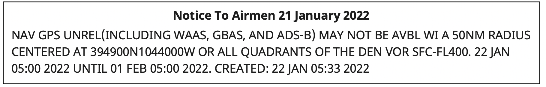
Something big happened to GPS service in the Denver area on Jan. 21.
On that day, Air Traffic Control issued a notice advising pilots of problems with GPS reception spanning about 8,000 square miles in the Denver area.
The advisory, posted at 10:33 p.m. Denver time, said GPS was unreliable within a 50-nautical-mile radius of the Denver International Airport. Interference was likely to be experienced by aircraft on the ground and as high as 40,000 feet above sea level.
The advisory also said the Wide Area Augmentation System (WAAS) and Ground-Based Augmentation System (GBAS), both designed to make navigation with GPS more precise, as well as the ADS-B collision avoidance and traffic management system, would be unreliable.
Pilots reported other systems affected such as transponders that help radar controllers keep track of aircraft, traffic alert and collision avoidance (TCAS) equipment, autopilots, electronic flight bags and terrain warning systems.
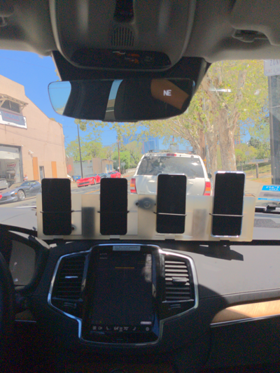
Pilots trying to land at Denver International and the much small Centennial Airport 20 miles to the south reported a variety of problems.
I flew in there (Centennial Airport) last night and I’m about to fly out. One second everything was fine, and then next second we completely lost GPS for the rest of the flight, probably coming through ~14,000 [feet] on the arrival from the northwest.
In addition to verbal reports to air traffic controllers, formal reports were filed with NASA’s Aviation Safety Reporting System (ASRS) by pilots flying into Denver International. (Note that ASRS only lists the month reports were submitted, not the day, to preserve anonymity.) Nineteen ASRS reports about GPS in Denver during January match well with comments on Reddit and an Airliners.net forum for the 21st and 22nd of the month.
The ASRS reports tended to focus on problems during approaches to the airport and landings. The most minor included distracting cockpit alerts and warnings.
Cleared ECAM (Electronic Centralized Aircraft Monitor) and emergency cancelled the repetitive nuisance messages. Additionally, received a GPS Lost message on FMC [Flight Management Computer].
More concerning were incidents that could more directly impact safety of flight.
One aircraft’s collision avoidance system, which normally reports issues as they develop, abruptly directed action to avoid another aircraft.
…we received a “LEVEL OFF” TCAS RA with no prior notification. The offending target was to our 2-3 o’clock and climbing…
Two aircraft reported confusing navigation displays on final approach to the airport. One pilot flying in limited visibility (instrument conditions) was sufficiently concerned that they aborted a landing attempt at the last minute.
We were about 1000 AGL [1,000 ft above ground level] – not sure about the exact altitude – and our RA [anti-collision warning] turned into an amber color… We were about 300 – 200 AGL and our autopilot failed… It was very unexpected… I called the go-around.
So, what happened to GPS?
At first, Air Traffic Control told pilots 5G telecommunications systems were causing the interference. That stopped at some point, though, according to an online comment:
As a [air traffic] controller… they haven’t told us anything. I was at work when it all started yesterday and they told us to make broadcasts about 5G interference. Today, they said it wasn’t 5G and not to make those broadcasts, but they still haven’t said what the issue is. There’s obviously rumors and speculation, but at this point, nothing concrete.
The first mention of the incident in traditional media seems to have been in an August 2022 journal article by a group of researchers at Stanford University. It focused on using the aviation ADS-B system to geo-locate GPS interference. The U.S. Department of Transportation provided the exact location and signal strength of Denver’s interfering transmitter to assist the Stanford study.
Requests in August and early September to the departments of Transportation, Homeland Security and Defense for more information on the incident went unanswered.
Mike Roskind from the Department of Homeland Security (DHS) provided some information and promised a formal report would be forthcoming. He said:
the incident lasted for 33.5 hours
impacts varied across infrastructures and applications; some users who were physically shielded from the interference source were able to maintain service
wireline and cellular providers had timing backup systems and were unaffected
a radio system with no backups suffered, as did a simulcast radio system that used rubidium backup clocks; the clocks drifted away from each other over the course of the outage and caused towers to isolate.
Responding to a question about the source of the interference, Roskind confirmed that 5G telecommunication was not the cause, but refused to say more.
He also declined to identify other systems, applications and infrastructure impacted by the disruption. He said that the department is very concerned about protecting the identity of affected users cooperating with the government analysis.
More information will be provided in a DHS report on the incident titled “GPS Interference Happens.” The report is in final review now, according to Roskind, and is expected to be released in October.
Trimble has released the Trimble TerraFlex Premium edition, a new tier of Trimble’s flagship geographic information system (GIS) data-collection software. The edition provides customers with offline GNSS corrections.
The new automated service works exclusively with Trimble GNSS receivers — including the Trimble DA2 receiver for the Trimble Catalyst positioning service — to provide high-accuracy GIS data capture in a wider range of locations and difficult GNSS environments than was previously possible.
TerraFlex users can increase the quality and speed of their data collection using offline GNSS corrections in situations where real-time services are intermittent or unavailable. Using the new service, all data from the field is automatically processed in the cloud without user intervention.
The most accurate real-time or offline processed position is stored for each feature, unlocking a high-productivity enhancement for all TerraFlex Premium subscribers.
Combining data-collection software and offline GNSS corrections into a single TerraFlex subscription simplifies both the workflow and the purchasing process for GIS organizations, from state and local governments to enterprise customers, including federal governments and utilities companies. This workflow to collect, process and deliver the most accurate and reliable positioning information reduces complicated manual processing steps and helps preserve data integrity.
Photo: Trimble
Streamlined post-processing using TerraFlex offline GNSS corrections is also available to Esri ArcGIS users, with the new Trimble Terra Office add-in for the Esri ArcMap GIS application. The new add-in replaces both the Trimble Positions Desktop and Trimble TerraFlex Desktop add-ins and supports offline GNSS corrections as well as existing desktop post-processing workflows. Terra Office is available as a yearly subscription.
“With Trimble offline GNSS corrections, we’ve taken the manual steps out of post-processing and made it as effortless as possible,” said Gareth Gibson, marketing director, Trimble Mapping and GIS. “This workflow enables TerraFlex customers to expand the locations and environments in which they work while still achieving high-accuracy results, and all without needing to become a GNSS expert.”
The TerraFlex Premium edition subscription is available through Trimble Geospatial Distribution Partners.
The TerraFlex offline GNSS corrections service uses a network of community base stations, and is broadly available in North America, the United Kingdom, Europe, Australia and New Zealand.
The Trimble Terra Office add-in for Esri ArcMap software is available through Trimble Geospatial Distribution Partners.
Fuel and fertilizer prices are at all-time highs, as farmers the world over are scrambling to find ways to stay financially afloat. Large commercial farms have long had a leg up over smaller holdings. They already have access to artificial intelligence (AI) and cutting-edge hardware to plan their operations and automate tasks. They run broad sensor networks to monitor soil quality, operate vision-enabled drones to monitor crop health, and let autonomous tractors steer across their fields to vastly improve their productivity.
These advanced systems have been prohibitively expensive, to the point that their costs are hard to justify for smaller holdings, less than two hectares in size, which make up the vast majority of the world’s more than 570 million farms. Many of these farmers simply don’t have access to sufficient capital to invest in new equipment, and continue to rely on older machines and human labor. For them, the vast promise of the digital revolution to increase the efficiency of agricultural operations — typically lumped together as smart farming or precision agriculture — has long remained just out of reach.
But change is in the air. Over the past few years, the popularization of the internet of things (IoT) and its underlying technologies has led to the development of a new and more affordable generation of precision farming solutions. These solutions are giving smallholdings tools to increase the quantity and the quality of their production. Combining satellite-based positioning, wireless connectivity and visual sensing with advanced algorithms including machine learning (ML) and artificial intelligence, these solutions promise to help farmers produce more for less, putting them on more equal footing with their larger commercial competitors.
In this article, we take stock of key trends driving the democratization of precision agriculture. We zoom in on some of the concrete applications transforming the operations of smaller farms the world over. We start by exploring the core enabling technologies, the applications they enable, and where they are headed.
Technological evolution on all fronts
Sensor-fusion platforms
At their heart, precision agriculture solutions are sensor fusion platforms, taking in data points from a variety of sensors, using algorithms to make sense of them, and extracting insights on which their users — machine or human — can act. As they mature, these sensor fusion platforms are becoming increasingly complex, crunching more and more types of sensor data with algorithms of growing sophistication to gain ever deeper and higher value insights.
These insights are often generated using AI and ML models that run at the edge of the network near the sensors — on the tractors, sprayers, or other devices themselves — rather than in the cloud.
Equipment manufacturers looking to integrate AI/ML at the edge are weighing their options in terms of adding application processors and hardware accelerators capable of running advanced ML models needed to fuse camera and sensor inputs to make real-time decisions. To simplify the adoption of AI/ML at the edge, many vendors are starting to integrate AI accelerators into their modules and systems-on-chip (SoCs), lowering the barrier to entry.
Original equipment manufacturers (OEMs), for their part, are choosing to integrate these SoCs even if their software capabilities are still behind. For them, building solutions with future-proof hardware is a potentially lucrative strategy for generating recurring revenues through firmware updates that provide advanced functions down the road.
Despite the abundance of evaluation kits from major vendors, scaling from prototypes to production with these solutions can be expensive. While integrated sensor fusion platforms with, for example, pre-loaded dynamic vehicle models for auto-steering or computer vision models for plant health can accelerate development for OEMs and reduce the need for software investment, they can be too generic and may not solve use-case-specific needs. More focused AI/ML may require more investment in data collection and training models, which, due to their proprietary nature could come at a higher price.
Camera systems are already widely relied on by autonomous tractors, visually monitoring the surrounding environment and feeding their data into computer-vision solutions where it is parsed. Context-rich, vision-based data can help optimize the distribution of agricultural inputs such as water, seeds, fertilizers and pesticides using real-time variable spray-rate control based on plant size and other metrics to significantly improve efficiencies and reduce overall costs.
Camera systems come with a set of challenges that need to be carefully managed. Lenses can become contaminated with water, debris, dust, and snow. Even though these issues impact all vision-based applications, including mass-market applications such as automated and autonomous driving, there are still no reliable methods of keeping them clean, aside from water-spraying nozzles (that can cause buildup on the lenses) and old-fashioned manual maintenance.
Additionally, the steep price of high-resolution cameras can drive up the cost of end solutions, as can data storage and communication when the visual data is processed in the cloud.
Global navigation satellite systems
Satellite-based positioning has also become a staple in precision agriculture solutions. Autonomous and guided tractors use the technology to drive vehicles along precise paths to increase pass-to-pass efficiency and reduce overlapping rows. Crop monitoring drones use GNSS technology to patrol predefined flight paths. And fully autonomous guided vehicles such as robotic lawnmowers use it to avoid restricted no-go zones. The latter three applications typically require centimeter-level positioning accuracies.
Centimeter-level GNSS technology has been available for well over a decade, with farmers subscribing to relatively costly GNSS correction services tailored to each user. However, it was only with the advent of affordable RTK services with availability in rural areas, as well as the dramatic decrease in cost for farmers to deploy their own RTK base stations using low-cost modules, that the price point of high precision positioning has come down far enough to make the service affordable to all but the least lucrative operations.
High precision GNSS technology brings the benefits of improved pass-to-pass efficiency – a general reduction of all agricultural inputs with all the financial, environmental, and health benefits that this entails. At the same time, it requires solutions to deal with signal delays and the resulting inaccuracies of multipath effects, caused when signals bounce off buildings, mountains, or other solid structures on their way to the GNSS receiver.
When delivered via the internet, the GNSS augmentation data stream requires an IP connection to the provider’s server. This poses challenges for farms that lack infrastructures such as Wi-Fi base stations, sub-GHz RF systems, or cellular network coverage.
Photo: Avalon_Studio/E+/Getty Images
Wireless connectivity
In some way or another, all advanced precision ag use cases depend on wireless connectivity. Environmental sensors and inspection drones need it to relay data to the cloud backend. Additionally, tractors, drones, and other farm robots depend on it to upload telematics data, report their status, enable predictive maintenance tools to reduce downtime, and receive GNSS augmentation data for high precision positioning.
While cellular connectivity is the easiest to use — all it takes to upload data straight to the cloud is a mobile data subscription and a SIM card — it has two key drawbacks. The first, mentioned earlier, is that the entire farm needs robust network coverage, which is not always a given in rural areas even in the United States and other developed countries. Also, when coverage is available, the cost of data transfers can quickly add up and become prohibitive for smaller, less profitable farms, as they may not be able to negotiate affordable connectivity plans as effectively as larger operations that have much higher data usage.
One way to address the coverage issue is by choosing the right wireless communication technology. Low power wide area technologies, such as LTE-M, NB-IoT, and Cat-1 solutions offer similar coverage to traditional LTE in many countries and are available at a fraction of the cost. When higher bandwidths are required, LTE Cat 4 or higher modules offer 150 Mbps+ of throughput. 5G modules enabling gigabit connectivity are available today, but solutions may cost up to 10-times more.
As an alternative, 5G Redcap – an upcoming 3GPP technology – seeks to provide a 5G compatible, affordable solution with medium bandwidth and lower complexity, enabling affordable hardware. We will likely start to see the first RedCap offerings from mobile network operators in 2025.
Artificial intelligence and machine learning at the edge offer an additional tool to reduce bandwidth requirements, by processing sensed data near the sensors themselves. Rather than streaming vast amounts of raw sensor data to the cloud, devices leveraging edge intelligence can reduce their wireless communication bandwidth requirements and cost by uploading only relevant information.
The trends driving democratization
Progress in sensing and sensor fusion platforms, camera systems, GNSS technology, and wireless connectivity is but one of the drivers democratizing precision agriculture. The other is an ongoing ecosystem-wide transformation that is breaking down many of the barriers that have kept precision agriculture solutions the preserve of large, lucrative farming operations.
Together, they are bringing down the cost of ownership of precision ag technology. Only just a few years ago, the only available solutions from major OEMs came with a hefty price tag, comprising expensive hardware and considerable recurring subscription fees, while requiring skilled labor to implement, operate, and maintain smart equipment.
Vendor lock-in enforced by locking telematics interface ports prevented farms from adopting aftermarket solutions — justified as a way to improve safety and vehicle reliability. Ultimately, however, this limited farmers’ ability to maintain their equipment themselves and to piece together cost-optimized solutions tailored to their specific needs using components from competing solution providers.
Today, all of this is changing. Hardware costs are down dramatically due, largely, to economies of scale unleashed by the Internet of Things’ explosive growth. Farmers now have access to affordable, user-friendly aftermarket solutions to upgrade tractors and other agricultural machines they already own that depend on a new generation of more cost-effective GNSS correction services. OEMs are introducing advanced functionality in their entry- to mid-range tractors in addition to their premium product line.
At the same time, the abundance of open-source projects, module-based solutions, and pre-certified radio technologies are making the development of precision ag solutions cheaper, bringing down the cost of off-the-shelf hardware. Add to that lower subscription costs for GNSS correction services thanks to improved broadcast distribution with SSR-RTK (state space representation-real-time kinematic).
The total cost of connectivity is dropping as well. Deploying connectivity infrastructure was long a non-negligible cost point, made up of wireless infrastructure and data subscription fees. Today, thanks to the increased availability of cost- and power-optimized wireless communication technologies with broader coverage (LTE-M, NB-IoT, LTE Cat 1), farmers can reap the benefits of the overall expansion of cellular network infrastructure.
Arguably one of the most promising trends driving the democratization of precision agriculture technology comes from the farming community itself in the form of do-it-yourself solutions based on open-source hardware and software designs.
Take AgOpenGPS, also referred to as AOG, an open-source auto-steering solution created by a Canadian farmer and software developer. AOG delivers all the hardware design files, the real-time microcontroller firmware, and software required to enable auto-steering on conventional tractors, regardless of their age. Thousands of hours invested by the AOG developer community have made the solution accessible to the masses, both financially — retrofitting tractors can cost less than USD $1,000 — and in terms of prerequisite knowledge.
A growing variety of precision agriculture platforms, from high-end commercial solutions that cater to the most profitable farms to low-cost do-it-yourself solutions that can pay for themselves in a year and are accessible to smaller, less profitable operations, are transforming the impact that precision agriculture can deliver. With the global food supply under tremendous pressure, this democratization of smart farming technology could come to play an important role in feeding the world.
To learn more about how u-blox enables high-precision autonomous vehicles and other smart farming applications, visit www.u-blox.com/precision-agriculture.
Apple co-founder Steve Wozniak will join Trimble CEO Rob Painter on the stage for the 2022 Trimble Dimensions+ keynote presentation.
Trimble Dimensions+ is a three-day user conference providing education, showcasing innovation and offering networking opportunities with Trimble users, customers and product experts from around the world. This year, the conference will be held in-person for the first time since 2018, and will be held Nov.7-9 at The Venetian in Las Vegas.
Wozniak and Painter to Present
CEO Rob Painter will kick off the conference with an inside look at how Trimble’s Connect & Scale strategy is enabling customers to do their work faster, better, safer, cheaper and greener. Connect & Scale provides innovative solutions to better connect people, technology, tasks, data, processes and industry lifecycles.
Painter will showcase transformative technologies that have had a positive impact on industries, projects and people.
Rob Painter
Painter will be joined on the main stage by Steve Wozniak, who exemplifies Trimble’s passion for innovation and technology. Like Charlie Trimble, the company’s founder, Wozniak began his career in Silicon Valley in the 1970s when he and Steve Jobs formed Apple Computer Inc.. This was was followed by the development of Apple I and II — Apple’s first line of products and integral to launching the personal computer industry.
On the Trimble stage, Wozniak will share his famed journey from computer geek to cult icon, entrepreneur and philanthropist.
The keynote will end with remarks from Aviad Almagor, vice president of Technology Innovation, who will provide a sneak peek at emerging technologies being developed at Trimble — including robotics, autonomy and artificial intelligence — and discuss how they are reshaping the future of engineering and construction.
About Trimble Dimensions
Trimble Dimensions+ user conference is a three-day, in-person event where attendees can better connect as a community for education, inspiration and innovation. The conference provides insight into how Trimble’s industrial technology can transform the way professionals work to succeed and drive sustainability.
Highlights include educational sessions and specialized tracks to advance career objectives, with many sessions qualifying for Professional Development Hour (PDH) credits and Continuing Professional Education (CPE) credits.
The conference includes
the Offsite Experience
hands-on training opportunities
keynote and executive-level presentations
an interactive Expo.
In addition to the in-person event, Dimensions also features the virtual, on-demand Spotlight Series that focuses on industry trends. The series is delivered by experts on technology transforming the way we work.
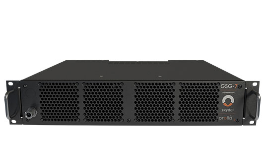
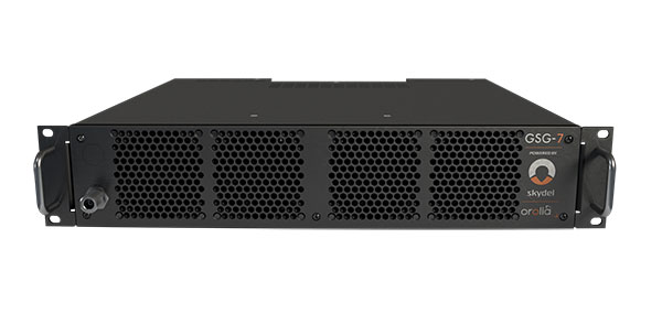
GSG-7 delivers the highest standard of GNSS signal testing in a cost-effective, easy-to-use, turnkey form factor supporting navigation and timing systems
Photo: Orolia
Orolia has released the GSG-7, its latest GNSS signal testing solution.
Orolia made the announcement at the ION GNSS+ conference, taking place this week in Denver.
Offered through the Orolia family of Skydel-based simulators, the GSG-7 features a small form factor, an internal RF combiner, high-end performance with a 1,000-Hz simulation iteration rate, real-time synchronization, hardware-in-the-loop (HIL) integration, powerful automation, and multi-constellation and multi-frequency simulations.
“The GSG-7 is redefining the essential and high capabilities in GNSS simulation with its ease of use, advanced simulation capabilities, reduced size, and competitive price,” said Lisa Perdue, simulation product line director. “Leveraging the powerful Skydel software and commercial-off-the-shelf (COTS) hardware, GSG-7 can accommodate almost any configuration to conduct system testing and simulation. The use of SDRs [software-defined receivers] means that maintenance and customization are not only easier, but more cost-effective than other options on the market.”
Powered by Orolia’s Skydel simulation engine, the GSG-7 can be programmed to simulate operations with all current GNSS signals, as well as future ones. Skydel’s architecture makes the GSG-7 future-proof by allowing new, incoming signals and updates to be implemented through software updates.
The GSG-7 simulator is suitable for development and integration projects that require high performance, all-in-view satellite signals, and an increased number of GNSS constellations.
“Capable of handling complex simulation scenarios, the GSG-7 has a simple, yet powerful application program interface (API) ensuring easy automation and integration into your test environment,” Perdue added. “Users can also benefit from advanced HIL capabilities that include zero-effective latency and built-in performance monitoring tools.”
GSG-7 Webinar
Orolia will host a product webinar on Oct. 6 to discuss the new GSG-7 in great detail. Topics will include:
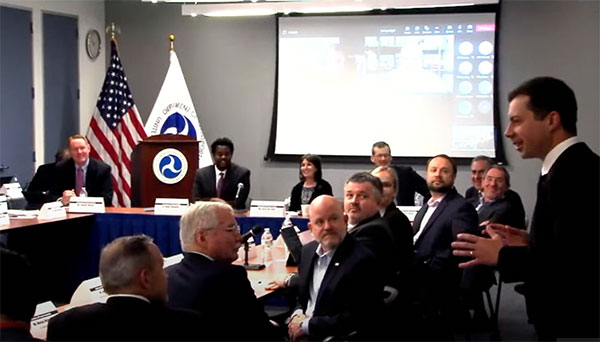
Transportation Secretary Pete Buttigieg made a surprise appearance at the DOT roundtable on complementary PNT. (Screenshot: DOT)
“If this is a problem, the government should act like it.”
Citing more than 10 years of government studies, warnings and promises, representatives from a wide variety of industries criticized the government recently for doing little to address an important national security problem.
At issue was the need for national backup capabilities for GPS and the essential positioning, navigation, and timing (PNT) signals it provides.
GPS signals are weak and easy to block or imitate. At the same time the signals are used by most technologies including networks, telecommunications, electrical grids, broadcast, mobile radios, transportation, and other critical infrastructures.
After Russia threatened to destroy all GPS satellites in 2021 in its run-up to invading Ukraine, a member of the White House National Security Council told a public meeting “GPS is still a single point of failure” for the nation.
The government was criticized for inaction at a “Complementary PNT Roundtable” hosted by the Department of Transportation (DOT) in early August. The department is the federal lead for civil GPS and PNT issues.
Eight attendees interviewed after the event reported a surprising unanimity of comments and concerns expressed by industry reps at the meeting.
Enough with the studies
A repeated theme was that the government has done enough studies to understand the problem and available technologies.
“They have been studying this for over twenty years,” one attendee observed. “The Volpe [Transportation Systems Center] report came out in 2001. And there have been lots of studies since then. All have just been refinements of those original findings.”
Another consistent theme was disdain for the idea that industry and the free market will solve the problem without government leadership and active support.
“GPS is free,” said one attendee from a company that provides PNT services. “We can and do sell to meet niche demands, but it is laughable to suggest we can ever sell enough subscriptions to be enough of a backup for GPS.”
A major telecommunications company rep echoed the sentiment. Wireless telecom is especially reliant on PNT. “We use GPS and would use Loran and low Earth orbit satellites if they were available, but we are not going to build it on our own. There is just no business case.”
“We have a big list of things we could do that would increase our resilience and/or cut costs,” said another telecom provider. “There is no big driver for most, though. No competitive pressure, no government mandates.”
Government must walk the walk
“The government has been telling us for over a decade that this is a problem,” said one attendee. “If that’s true, why aren’t they acting like it? Transportation is critical infrastructure and needs a GPS backup, for example. So why hasn’t DOT done something?” Of all the criticisms expressed, this was predominant, according to interviewees.
A 2021 Executive Order on responsible use of PNT services encouraged critical infrastructure providers to not rely on GPS.
The government needing to be a lead customer was mentioned a number of times at the event. This would help raise awareness, set an example, and signal to users the issue is important enough to act on.
Government action was also seen by users as key to creating confidence that a technology or service will be around for the long haul. This point seemed to resonate with many of the government representatives as well.
“I am not going to go to the time and expense of adopting something unless I know it is going to be around for 20 years or more. The only way I can be assured of that is if one of the biggest users is the government.”
Adversaries not idle
Of particular concern to some was that America’s adversaries have better, more resilient PNT, and are constantly working against us.
They are building PNT “…systems of systems. Space-based, ground-based, and everything in between-based. They are doing it. We need to get out in front and lead,” said one. China has been particularly active building multiple integrated PNT systems.
“Our adversaries are not stupid” and are going to try to stay in the lead. “They will try to interfere with any frequency, system, or combination of systems selected. We must test and build something that is survivable and resilient.”
“If China, Russia, and Iran had the ability to protect themselves from nuclear attack,” said one attendee, “we would be frantically trying to get the same capability. Yet those countries have backup and complementary systems for PNT, and the United States does not. And we’re not doing anything,” said a participant reflecting upon the event.
Hopeful signs
Several attendees said there were signs the event might not have been “just another government meeting.”
As part of his opening remarks, the event host, DOT Deputy Assistant Secretary Dr. Robert Hampshire, mentioned the bipartisan infrastructure law and affirmed that PNT is infrastructure. This led some to believe funding from the infrastructure legislation could be immediately available if the government decided to act.
Others were cheered by DOT Secretary Buttigieg’s cameo appearance and comments at the event. One remarked it was the first time they had heard a DOT Secretary say “PNT” in over 20 years.
Uncertain outcome
Despite the consistent messaging and potentially hopeful signs, some attendees questioned whether anything would change because of the two-and-a-half-hour event.
“There were about 120 people from industry and a wide variety of government agencies, but what was the point?” asked one. “We all told the government the same things we’ve told them before, often in writing.”
Another was concerned that the event didn’t discuss the most important questions.
“We were talking about individual systems and critical infrastructures,” this person said. “This is a strategic national security issue. We need to get the bullseye off GPS and ensure the United States can’t be blackmailed by having GPS held hostage.”
“And what if there is a major coronal mass ejection? China will come out much better than us because they have survivable PNT. The United States will become a second-rate power to China in an instant. We keep talking about the trees and ignoring the forest!”
One attendee whose company has a very active government relations program reported they hoped the event would help sway those in government still opposed to action.
“It is pretty clear to us that almost everyone in the departments who understand the issues is in favor of doing something as soon as possible. The same with Congress. But even though the National Security Council is worried about this, there are some folks in the Office of Management and Budget who have opposed action for over a decade.”
While some came away buoyed by what they saw as an action-oriented tone to the event, others doubted much would change. “It remains to be seen whether criticism from industry and threats from China and Russia are enough to get the government to finally do something.”
Dana A. Goward is President of the Resilient Navigation and Timing Foundation and serves on the President’s National Space-based Positioning, Navigation, and Timing Advisory Board.
WAAS makes airports without ground-based navigation available to pilots. (Photo: Raytheon)
WAAS monitors and evaluates all GPS signals over North America to enable pilots to fly using augmented GPS data for precision landing and enroute navigation
Raytheon Intelligence & Space, a Raytheon Technologies business, has been awarded a competitive indefinite-delivery, indefinite-quantity contract from the Federal Aviation Administration with a ceiling value of $375 million over the next 10 years.
Task orders, valued at $215 million, were executed at contract award to provide technical refresh and dual-frequency operation (DFO) upgrades to the FAA’s Wide-Area Augmentation System (WAAS) to provide safer air travel in support of the National Airspace System.
WAAS monitors and evaluates all GPS signals over North America to enable pilots to fly using augmented GPS data for safety-of-life missions such as precision landing and enroute navigation. The system allows pilots to safely land in places previously inaccessible because of the airport location or weather. It also makes airports without ground-based navigation available to pilots.
Under the WAAS DFO-2 contract, Raytheon will deliver more modern, and therefore sustainable, processing, system security, and network architecture, while also adding dual-frequency service.
“There is no margin for error during take-off, flight or landing,” said Denis Donohue, president, Surveillance & Network Systems at Raytheon Intelligence & Space. “Our modernization effort for WAAS will improve system robustness during ionospheric events and ensure safety-of-life requirements continue to be met.”
WAAS is a satellite-based augmentation system (SBAS) that provides GPS corrections for critical navigation for the aviation community, first responders and other government agencies, ensuring pilots can land safely in austere environments, despite weather challenges. It also provides corrections for SBAS-capable receivers in use across a diverse set of communities, including agriculture, maritime and surveying, among others.
Raytheon Technologies has been the prime development contractor for WAAS since 1996. Since reaching initial operational capability in 2003, Raytheon and the FAA have developed and fielded dozens of enhancements expanding WAAS’ precision approach capability, coverage area, and reliability, including improvements to the system infrastructure in preparation for dual-frequency service.
WAAS dual-frequency service will enable increased system accuracy, integrity and availability when subject to ionospheric perturbations, including solar storms. Work for this effort is based in Fullerton, California.
Founded in 2012, GeoSLAM is a provider of mobile scanning solutions with proprietary high-productivity simultaneous localization and mapping (SLAM) software to create 3D models for use in digital twin applications.
The addition of GeoSLAM is expected to significantly expand and accelerate Faro’s market growth in the mobile scanning space.
“We are thrilled to add GeoSLAM’s handheld 3D scanning technology to our portfolio of cutting-edge data capture solutions,” said Michael Burger, Faro president and CEO. “Faro now offers the industry’s broadest set of 4D data-capture solutions, including 360° camera-based images, mobile scanning and stationary high-accuracy laser scanning, allowing customers to balance the need for accuracy, speed and detail depending on their requirements. These capture technologies provide the foundation for our 4D digital-reality-based SaaS (software-as-a-service) offering that will allow customers to access multiple 4D data sources for visualization and analysis through a single user experience. We welcome the GeoSLAM team to our Faro family.”
“Joining with Faro represents the next step in the growth of GeoSLAM and the establishment of mobile mapping as a driver for growth in the way businesses map and understand their spaces,” said Andy Parr, GeoSLAM CEO. “Both companies share a vision of the importance of mobile scanning in the burgeoning digital reality capture market.”
GeoSLAM reported £14.5 million in revenue with 18% EBITDA in the fiscal year ending March 31, 2022. EBITDA, a non-GAAP measure, is calculated as net income/loss before interest (income) expense, net, income tax expense (benefit), foreign exchange rate variance, and depreciation and amortization. The transaction closed on Sept. 1, funded with available cash reserves and equity consideration.
Under terms of the agreement, GeoSLAM shareholders received a cash payment of £22.0 million and 495,562 shares of Faro stock subject to customary lock-up provisions. Faro expects the acquisition to be accretive to Non-GAAP EPS in 2023.
Faro serves the markets of architecture, engineering and construction (AEC); facility operations and maintenance; 3D metrology; and public safety analytics.
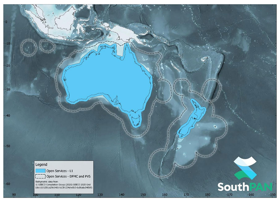
SouthPAN early Open Services coverage. (Image: Geosciences Australia)
The government of Australia has awarded Lockheed Martin a $1.18 billion contract to establish the Southern Positioning Augmentation Network (SouthPAN) to enhance precision.
The system is expected to be fully operational by 2028, and will be provided as a service for 19 years with an option to extend.
The program will use a unique, Lockheed Martin-developed, second-generation satellite-based augmentation system (SBAS) broadcasting on two frequencies to augment signals from two GPS and Galileo.
The SouthPAN initiative
The SouthPAN initiative will deliver a signal augmenting GPS and Galileo over the Australasia region, improving accuracy from 5-10 meters to within as little as 10 centimeters.
The greater positioning accuracy and integrity of the SouthPAN signal has applications across a range of users, including civil aviation, vehicle guidance, precision agriculture for efficiencies in crop management, tracking maritime shipments, and enabling navigation for drones and other unmanned vehicles.
Lockheed Martin Australia will work with the SouthPAN project team to establish a network of GNSS reference stations and satellite uplink facilities that will enable communications and transmissions with the SouthPAN space infrastructure.
SouthPAN is a partnership between Geoscience Australia and Toitū Te Whenua Land Information New Zealand (LINZ) under the Australia New Zealand Science, Research and Innovation Cooperation Agreement.
2017 testbed
Lockheed Martin tested a second-generation SBAS testbed in partnership with Geoscience Australia in 2017.
Lockheed Martin’s second-generation SBAS technology receives and monitors basic signals data from multiple GNSS through widely distributed reference stations. This data is collected by a SBAS testbed master station, which computes corrections and integrity bounds for each GNSS satellite signal, and generates augmentation messages.
The new messages are sent to an SBAS payload hosted aboard an Inmarsat geostationary Earth orbit satellite via an uplink antenna in Uralla, New South Wales. The Inmarsat satellite rebroadcasts the augmentation messages containing corrections and integrity data to the end users’ GNSS receivers. The whole process takes less than six seconds.
Lockheed Martin provided the systems integration expertise in addition to the Uralla radio frequency uplink; GMV-Spain provided its “magicGNSS” processors; Inmarsat provided the navigation payload hosted on the 4F1 geostationary satellite. The Australia and New Zealand Cooperative Research Centre for Spatial Information coordinated the demonstrator SBAS test-bed SBAS test-bed projects.
The SouthPAN contract will expand Lockheed Martin’s investments toward sustainable business growth in Australia. Currently, Lockheed Martin programs support 4,000 Australian jobs in advanced manufacturing and technology industries. The contract will grow that footprint with additional jobs in at least four states.
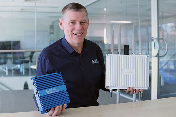
CEO Paul Gray displays the MK6 OBU (left) and RSU. (Photo: Cohda Wireless)
Cohda Wireless has developed an advanced and versatile V2X connectivity solution to help pave the way for the introduction of connected vehicles on smart roads and highways across the globe.
The MK6 RSU (roadside unit) and OBU (onboard unit) offer a comprehensive connectivity capability as standard features, including DSRC, C-V2X, LTE/5G and Wi-Fi/Bluetooth.
The Australian-headquartered company believes the MK6 will expedite the rollout of cooperative intelligent transport systems (C-ITS) around the world. Cohda’s V2X stack and applications are widely deployed in the industry, and the MK6 is the company’s most capable, versatile and powerful platform to date.
The dual concurrent technology capability of the MK6 gives users the reliability, flexibility and interoperability needed to embark on deployments with confidence, no matter where they are in the world, said Paul Gray, Cohda Wireless chief executive officer.
“More and more cities across the world are actively embarking on initiatives to introduce connected vehicles on their roads and we developed the MK6 with the intent that it would become the undisputed connectivity solution of choice,” Gray explained.“City transport authorities want to invest confidently in future-proof products, and when they equip their traffic lights and other roadside infrastructure with the MK6 Road-Side Unit, they are deploying a road-ready solution that can reduce congestion and road accidents.”
The MK6 also offers improved security and processing power for unique and complex applications, Gray said.
In developing the sixth-generation MK6, Cohda applied its experience and involvement in some of the world’s most prolific trials and deployments, including the 3,000-vehicle New York Connected Vehicle Project as well as Australia’s largest connected vehicle pilot, the Ipswich Connected Vehicle Project.
Cohda’s technology has featured in two production vehicle platforms, most recently in 2019 when Volkswagen equipped its Golf 8 production model with Cohda’s V2X. Volkswagen is the second manufacturer to incorporate Cohda’s V2X technology in a production vehicle in readiness for an impending connected road transport system.
“We are approaching a tipping point and we expect the MK6 to be a catalyst for increased momentum,” explained Gray.
“The MK6 is the all-rounder solution that makes it easy for the entire industry, especially cities and transport authorities, to participate in the evolution of the world’s transport systems,” Gray added.
The MK6 features the RoadLink SAF5400 and SXF1800 chipsets from NXP Semiconductors, as well as the Qualcomm Snapdragon Auto 5G Modem-RF Platform. It will be available in December.
From left: Yusuf Kıraç, Türk Telekom chief technology officer, and Net Insight CEO Crister Fritzson. (Photo: Türk Telekom)
Türk Telekom is using specialized GPS/GNSS-independent technology to provide critical time and frequency synchronization in its 5G network.
The technology — developed by Türk Telekom engineers with Net Insight — is expected to significantly reduce synchronization investment costs and increase service continuity in 5G. The companies did not reveal the details of their technology.
Türk Telekom, the pioneer of digital transformation in Türkiye, continues its efforts to shape the future with 5G and new generation technologies. Türk Telekom became the first operator in the world to implement the “Time Synchronization Transmission Solution,” implemented in cooperation with Net Insight, one of the world’s leading technology companies, on its network. This solution, which is the patented technology developed by Türk Telekom and Net Insight, will provide strategic superiority in network technologies.
Minimum end-to-end deviation throughout Turkey
The testing process of the GPS/GNSS-independent stable synchronization service for 5G has been successfully completed. Türk Telekom, which has installed the system at 20 locations in Turkey, will have a central synchronization network with high time accuracy, and will be able to offer synchronization service to 5G base stations.
While the highest time deviation value for 5G is 1,500 nanoseconds, the deviation value was measured at 5–45 nanoseconds in two different regions of Türkiye, according to the first data obtained from the Türk Telekom live network. The values revealed that sensitive time and synchronization information can be carried from Edirne to Hakkari, the entire length of Türkiye, with minimum deviation regardless of network equipment.
Solution to increase efficiency and save resources
“We became the first operator to implement the next-generation synchronization solution, developed together with Net Insight and leveraging patents of Turkish engineers, which is critical for 5G and beyond technologies on the live network,” said Yusuf Kıraç, Türk Telekom chief technology officer. “We see a significant potential in the global market for this innovative solution that will reduce costs and increase service continuity for mobile operators and all industries with critical time synchronization requirements.
“We can meet all these needs with this solution, which has a time deviation far below 1,500 nanosecond required for the synchronization need of 5G,” Kıraç continued. “We are proud to develop new satellite-independent solutions for operators and standardization organizations in the world.”
“We believe that this solution, which is operated on the Türk Telekom network for the first time in the world, will break new ground in 5G and have a high and significant market potential on a global scale,” said Net Insight CEO Crister Fritzson.
Important step for 5G and beyond
The new-generation time synchronization solution, which is not depending on GPS/GNSS satellites, offers unique advantages for transmitting phase and time synchronization over the network without the need to replace or update existing network equipment. With this technology, a fundamental solution to GPS/GNSS satellites’ signal interruptions and service losses — one of the biggest needs of operators who have switched to 5G — will be met, the companies said.
At the same time, the synchronization needs of 6G technologies — planned to begin global standardization studies in 2025 — will be met with the same solution.
The patented technology will be produced and marketed all over the world and will provide solutions for sectors such as telecommunications, energy and finance.