Hexagon AB, a global leader in digital reality solutions, has acquired the Jovix software and services business from Atlas RFID Solutions LLC of Birmingham, Alabama.
Jovix is a material tracking software developed specifically for the construction industry, providing project decision-makers with real-time, actionable data regarding material status and location.
The cloud-based and mobile configurable workflow platform offers visibility and traceability into the status and location of materials throughout the engineering, procurement and construction (EPC) lifecycle. This streamlined process, coined “material readiness” by Jovix, ensures construction crews have required materials without delay to complete their work according to plan. This is achieved by fully digitizing the supply chain to provide real-time, geo-contextual, and relational visibility from fabrication to installation.
Jovix combines web-based server software with information from multiple types of sensor tags and readers to automate previously manual, paper-based data-collection workflows about the status and location of material as it moves throughout the construction supply chain.
The software has been deployed in 25 countries on more than 650 job sites, including multibillion-dollar oil and gas and chemical construction projects. There are more than 7,500 Jovix users worldwide.
“The acquisition supports our continued expansion into the procurement, fabrication, and construction market,” said Hexagon President and CEO Ola Rollén. “By removing impediments to productivity that result from material management issues intending to reduce material wait times to zero, Jovix provides value for owner-operators, EPC firms, contractors, fabricators, and suppliers.”
Jovix will be fully consolidated as of Oct. 1, operating within Hexagon’s Project Portfolio Management division. The acquisition has no significant impact on Hexagon’s earnings.
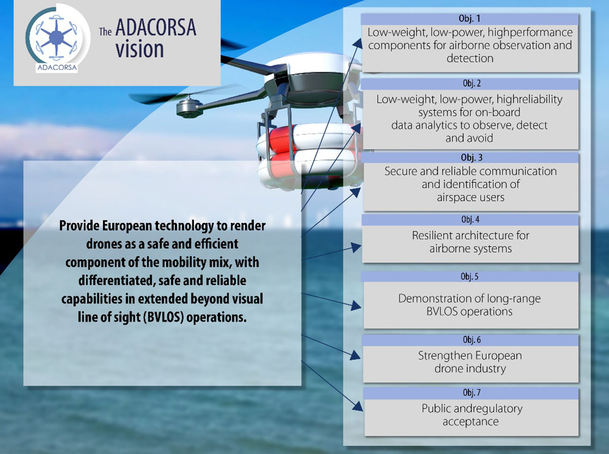
Celestia Technologies Group (CTG) is taking part in the ADACORSA project, a European initiative designed to unlock the potential of long-range and beyond-visual-line-of-sight (BVLOS) drones and give Europe a world-class drone industry.
ADACORSA — Airborne Data Collection on Resilient System Architecture — is a major collaborative project launched in May 2020 that aims to demonstrate the safety and efficiency of drones or unmanned aerial vehicles (UAVs) in extended out-of-line-of-sight operation ranges.
Specifically, it draws on European expertise in developing sensor and communication technologies for UAVs to underpin their role and reliable capability in long-range applications, including observation, analysis and transport, taking them one step further toward being integrated into conventional airspace.
ADASCORA also seeks to increase public and regulatory acceptance of modern UAV or drone technology. More than 49 specialist companies from 12 European countries are expected to contribute know-how and practical support. The project also aims to research and develop innovative components and systems for airborne observation and detection, telecommunication and data processing along the electronics value-chain.
Task Forces Established
To meet ADACORSA’s ambitious targets, task forces have been set up, one of which will be led by CTG. The company will lead the development of electronic components for reliable and fail-operational environment perception and run one project demonstrator designed to integrate unmanned aircraft systems safely into the common European airspace and ensure that they operate correctly in a multi-unmanned aircraft system environment.
CTG is a Dutch supplier and part of a pan-European company group providing innovative technology products, systems and services to space, aerospace, defense, telecommunications and scientific markets.
Galileo + EGNOS Transponder
CTG will use its expertise in on-board UAV electronics to develop a lightweight, high-performance transponder capable of sending and receiving accurate identification and location data for unmanned aerial vehicles.
Positioning will be based on Galileo, supplemented by its European Geostationary Navigation Overlay Service (EGNOS), allowing all airspace users to know the location of the vehicle and contribute to safety while supporting other on-board systems such as detect-and-avoid equipment.
The transponder will be based on conventional aviation technologies such as Mode S Interrogator and Automatic Dependent Surveillance-Broadcast (ADS-B) and will integrate new concepts including network identification, meaning the vehicle can fly safely in various scenarios. These include in locations close to airports, in drone fleet operations and within the U-Space environment. U-space is a set of European services and procedures designed to support safe, efficient and secure access to airspace for drones.
ADACORSA has received funding from the ECSEL Joint Undertaking (JU) under grant agreement No. 876019. The JU receives support from the European Union’s Horizon 2020 research and innovation program and Germany, Netherlands, Austria, Romania, France, Sweden, Cyprus, Greece, Lithuania, Portugal, Italy, Finland and Turkey.
Skycatch is offering new data-capture capabilities for the DJI Matrice 300 through its proprietary Flight1x software — a key component of the company’s High Precision Package.
The High Precision Package provides mining operations with cloud or edge-based data processing that enables viewing terrain in 4D, automated RTK/PPK industrial drone management, and fast edge processing with data visibility in minutes.
Built on technology adopted by companies Komatsu Mining and AngloAmerican, Flight1x outperforms traditional off-the-shelf data mapping tools by including purpose-built flight automation software for the M300, leveraging DJI’s L1 and P1 sensors.
The solution delivers data and network security via Skycatch servers in the United States, coupled with advanced automation features like a 3D first-mission planner, mining-focused workflows and deep integration into Skycatch’s data analytics platform Datahub.
The Flight1x software will work with the M300 to help mining engineers quickly extract data. Features include:
fully automated capture, extraction and processing of high-precision 3D point clouds
highly specialized mission-planning automation to extract data from complex terrains such as high walls
complete industrial data capture and processing for repeatable and automated spot inspection
consistent data-retrieval analysis of thousands of terrain spots in a single location by an automated industrial drone
fully automated aerial robot technology built on Skycatch’s automation platform, eliminating the need for manual pilots and reducing risk of human error.
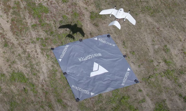
Wingcopter drones recently transported blood samples 26 kilometers (16 miles) between Greifswald and Wolgast, Germany. The flights were carried out by Greifswald University Medical Center in cooperation with DRF Luftrettung and Wingcopter as part of the MV|LIFE|DRONE Challenge (MVLD-Challenge) project of the hospital’s Department of Anesthesiology.
The project, funded by the German Federal Ministry of Health and the Ministry of Energy, Infrastructure and Digitalization of Mecklenburg-West Pomerania, is a partnership between University Medical Center Greifswald and DRF Luftrettung. The goal of the project is to improve structures of regional emergency care by integrating unmanned aerial vehicles (UAS, Unmanned Aerial Systems) into the rescue chain and into medical emergency transports.
The flights beyond the pilots’ visual line of sight (BVLOS) carried a pneumatic tube including 250 grams of blood samples. The Wingcopter completed the 26-kilometer route in an average of 18 minutes, nearly twice as fast as ground-based transport.
The use of Wingcopter drones could significantly speed up emergency medical care in rural areas and help save lives. In the event of a blood transfusion being necessary at short notice, for example, blood samples from Wolgast District Hospital must be transported to Greifswald University Hospital for analysis in order to determine the appropriate donor blood.
“With this project, we have demonstrated that we can also improve medical care and quality of life in rural areas in Germany,” said Ansgar Kadura, co-founder and CSO of Wingcopter. “With our new unmanned aerial vehicle, the Wingcopter 198, this can be carried out even more efficiently in the future. We look forward to continued collaboration with the project team at the Department of Anesthesiology as part of the MV|LIFE|DRONE Challenge and beyond.”
The Greifswald University Medical Center seeks to establish permanent flight connections between the medical center in Greifswald and hospitals in the surrounding area as soon as possible. Drones can also be used to support first responders on site by quickly transporting medications, transfusions or emergency medical equipment such as defibrillators to the scene of an accident.
All four current GNSS and two regional systems have been built and are operated by public agencies. Many correction services and complementary PNT services are operated by private companies.
Going forward, what do you expect the division of labor to be between the public and private sectors in building and maintaining PNT capabilities? What should it be?
Ellen Hall
“The space race was championed by governments. Space travel, communications and other technologies were born from government exploration into space. Today we see many private companies engaged in space. Several are intent on supplementing GNSS navigation, and some envision competing. Private companies have a way to go if they plan to compete with systems like GPS, but competition is often at the center of innovation and may benefit everyone.” — Ellen Hall Spirent Federal Systems
Jules McNeff
“GNSS and regional systems are established and sustained to meet the needs of the governments and public agencies that operate them. They cover wide areas and provide services to extremely diverse user communities at levels of performance based on resources that are justified by user requirements and limited by technical affordability. When the global/regional service levels don’t meet the needs of a particular user group or require backup for security, the opportunity is opened for other agencies or private companies to create augmentations and complements to meet the additional needs. The mix is variable and will be determined by the user groups and the market.” — Jules McNeff Overlook Systems Technologies
F. Michael Swiek
“There is really no single ‘correct’ answer or specific division of labor between public- and private-sector entities in GNSS. The situation we see today is the result of decades of constructive and successful ad hoc evolution of roles among and between public- and private-sector entities. Public agencies are better suited to provide foundation technologies and infrastructure due to the large costs and long timelines associated with establishing the constellations and maintaining stable and consistent service. The private sector is better positioned to provide variety and timely flexibility in developing innovative solutions to the broad range of constantly emerging user requirements across all market segments. This unofficial and continually evolving division of labor has worked successfully and continues to adapt to the evolving world of PNT.” —Michael Swiek GPS Alliance
Three test trains, one per rail operator (SNCF, DBN Netz and SBB/Siemens), are used to collect real data. Above is an SBB train in the Lavaux-Oron district, Switzerland. (Photo: RomanBabakin/iStock/Getty Images Plus/Getty Images)
The European Railway Traffic Management System (ERTMS) could start using Europe’s space solutions to manage rail traffic.
A project funded by the European Union Space Program Agency (EUSPA) is taking steps toward providing a cost-efficient train-tracking solution based on satellite technology, together with other sensors and data.
Knowing the exact position of each train is at the heart of rail operations across the European Union (EU). ERTMS is a major industrial EU project to create a more efficient and safer interoperable railway system. It currently relies on a series of costly ground instruments. In the coming years, ERTMS could switch to EU space solutions.
In a project dubbed CLUG — short for Certifiable Localization Unit with GNSS — experienced rail operators and infrastructure managers came together to define a set of specifications and operational scenarios that meet the most stringent safety needs of the rail sector. The specifications are used by the architects of the CLUG consortium, who are in the process of rolling out the system.
The project’s goal is to assess the creation of a failsafe train localization onboard unit (TLOBU) interoperable across the entire European railway network. The TLOBU will provide trains and railway operators with critical information such as positioning and velocity, complemented by acceleration, heading and attitude for applications.
“Seen & Heard” is a monthly feature of GPS World magazine, traveling the world to capture interesting and unusual news stories involving the GNSS/PNT industry.
Photo: nattrass/iStock/Getty Images Plus
SMARTWATCH REVEALS RUNNER’S FATE
On the morning of July 10, Berkeley resident Philip Kreycik went for a run in Pleasanton, California. That day, temperatures reached 106 degrees, and he didn’t return home. His body was found Aug. 3, reports the San Francisco Chronicle. His Suunto smartwatch stopped tracking movement 4.5 hours after he started his run. GPS data from the watch showed him moving in erratic zigzags and circles before he stopped. Experts concluded he experienced delirium before succumbing to heat exhaustion.
Organized gangs riding e-scooters are stealing high-value GPS/GNSS technology from farms in the United Kingdom, reports BBC News. Insurer NFU Mutual said the cost of replacing the stolen equipment nearly doubled in a year to £2.9 million. The technology, in worldwide demand, has become the “rural thieves’ top target,” the insurer said. GPS/GNSS equipment on tractors can cost up to £10,000 per unit.
SPACE FORCE RECRUITS WITH GPS
A 13-minute recruitment commercial from the U.S. Space Force debuted Aug. 24, with GPS as a star. “There’s no such thing as a day without space operations. You just don’t see them,” explains the video, mentioning how GPS is key to the operation of ATMs, cell phones, gas pumps, traffic lights, power grids, guided missiles and more. The commercial states that the Space Force is seeking guardians who will help protect satellites from attack and debris. Current guardians describe the importance of GPS. “We won’t just think outside the box, we’ll think outside the atmosphere, in one of the most challenging environments ever known,” concludes the video. “The sky is not the limit.”
THIEVES STEAL TRACKERS AND… (GUESS THE REST)
Two burglars who stole a package from a drop-off box were quickly apprehended — the package was filled with Roambee GPS-based trackers heading to a COVID-19 vaccine maker for use in tracking shipments. The Santa Clara Police Department was ecstatic to learn what the thieves had stolen, reports Roambee, who knew the package had gone missing. Unaware of what was in their trunk, the thieves traveled more than 761 miles around the Bay Area before being arrested 14 days later on July 18.
2J Antennas has introduced the Stellar series, antennas designed for a large suite of devices with a focus on GNSS, sub-6 GHz, 5G NR, 4G LTE, 3G, 2G and WiFi-6E technologies.
The Stellar Series is suitable for law enforcement, medical transportation, fire rescue and other applications where mission-critical communication is a requirement. The antennas are designed to reliably provide real-time connectivity in a small size.
This series includes single or up to 9-in-1 configuration choices within the range of 617 MHz to 7125 MHz frequency bands.
The patent-pending technology reduces the antenna footprint by 55% while implementing a new double trifilar design and longitudinal resonances for MIMO/ARRAY configurations that traditionally have more complex size restrictions (such as B71 band/600 MHz).
Each antenna configuration uses symmetrical or asymmetrical resonators for negative sections of the antenna, resulting in maximum performance at low and mid frequencies. The Stellar series offers magnetic and adhesive mounting choices, making them suitable for temporary installations.
For permanent installation, 2J Antennas also offers the screw mount option in its roof series. The low-profile and lightweight housing introduces a new design that offers a more cost-effective solution for suppliers and distributors.
“We are excited to reinvent antenna designs to meet the fast-growing global markets and offer antenna solutions with the highest quality while reducing antenna sizes as much as possible,” said Ruben Cuadras, director of engineering. “We are proud to continue to bring antenna solutions to customers that require small device integration, reliability and new designs.”
The National Geospatial-Intelligence Agency launches Phase 4a of MagQuest Challenge to advance NASA’s ability to measure Earth’s magnetic field
The National Geospatial-Intelligence Agency (NGA) has launched the Demonstration Phase (Phase 4a) of its MagQuest Challenge to develop novel data-collection approaches for the World Magnetic Model.
The WMM ultimately ensures the accuracy of navigation, because it corrects for differences in magnetic forces at a user’s location. The model is used by thousands of systems for mobile navigation apps and is critical for military and commercial uses around the world.
Produced since 1905, the WMM originated with data collection from two ships surveying 500,000 miles of ocean. Today, the data is collected by satellites operated by the European Space Agency that will eventually reach the end of their useful life.
NGA’s MagQuest Challenge is promoting the development of miniaturized solutions to determine whether they can produce data useful to support WMM production. NGA has an extensive network of government partners collaborating on the WMM production, including the National Oceanic and Atmospheric Administration (NOAA), the British Geological Survey, the Federal Aviation Administration (FAA), the Department of Defense (DOD), the United States Geological Survey (USGS), and the United States Naval Observatory (USNO) among others.
As part of its core mission, NGA provides geospatial intelligence products and services to decision makers, military service members, and first responders.
The MagQuest Demonstration Phase 4a will take place on HeroX, a social network platform for crowdsourced solutions.
Three winning teams from Phase 3 of MagQuest each proposed a magnetometer design to measure the Earth’s magnetic field. In this new phase, the teams will receive several million dollars in awards, including a $1.55 million incentive prize purse, to develop their proposed magnetometers. NASA Goddard Space Flight Center will conduct independent testing on each team’s prototype.
Following Phase 4a, successful teams will integrate their magnetometers into their satellites and launch their systems, acquire data and share their results with NGA.
“Our ultimate goal is for all three teams to successfully develop a magnetometer, each of which can be sent into orbit to determine viability for WMM production,” said Mike Paniccia, NGA program manager for the World Magnetic Model. “We want to test as many innovative and groundbreaking magnetometers as possible to ensure that NGA has a robust set of data suppliers to support the future of the WMM. We intend to have a competitive procurement for a data-buy contract following MagQuest and hope that these three teams, in addition to others from industry, will be able to supply comprehensive data sets to support the future of the WMM.”
Three of the teams that participated in Phase 3 were selected to participate in Phase 4:
Iota Technology, the first-place Phase 3 winner, works alongside experienced teams from Oxford Space Systems and AAC Clyde Space. Their combined expertise in sensor technology, deployable structures and mission design informed the design of their SIGMA solution — a 3U CubeSat featuring a novel deployable boom and a 3D magnetometer array.
University of Colorado Boulder is one second-place Phase 3 winner, and their solution, COSMO, leverages recent innovations in CubeSat technology and novel magnetometer technology. The University of Colorado Boulder team includes experts and faculty from the Department of Aerospace Engineering Sciences, the Department of Mechanical Engineering, and the Laboratory for Atmospheric and Space Physics, and they operate their missions entirely at the university, including using their own ground stations.
Spire Global and SBQuantum formed a partnership with a promising approach to become the other second-place Phase 3 winner. SBQuantum’s novel diamond-based quantum magnetometer technology is coupled with Spire’s expertise and existing infrastructure in satellites, ground stations and data processing to produce a unique solution.
“This MagQuest Challenge is a testament to the power of the crowd,” said Kal K. Sahota, CEO, HeroX. “We are pleased to be part of securing the future of geomagnetic data collection and consequently contributing to the resilience and continued crucial work of the WMM.”
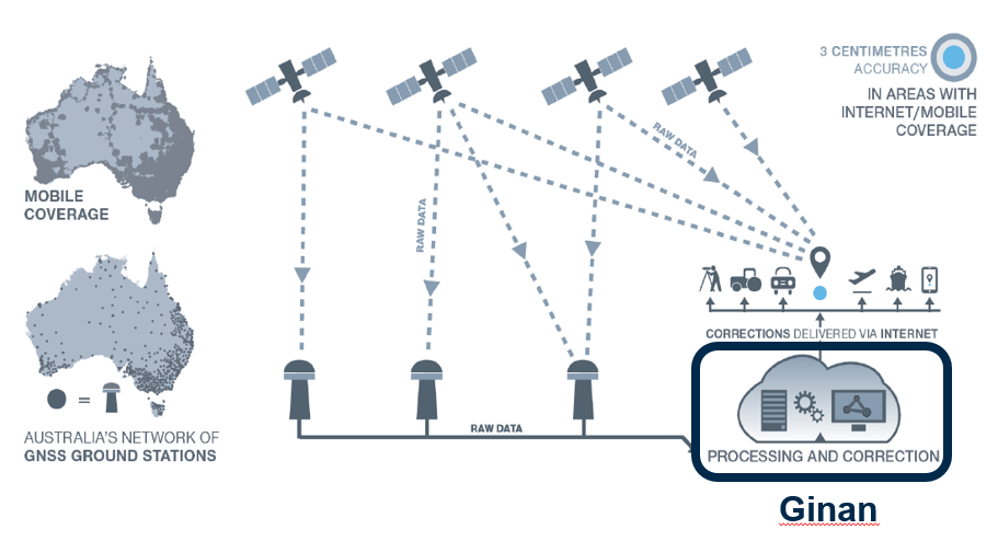
Geoscience Australia is developing open-source software — named Ginan — that will provide real-time corrections to positioning signals of all the GNSS constellations.
Once operational, Ginan will improve the accuracy of location data from 10 meters down to 3 to 5 centimeters for users with an internet and mobile connection. It will enable industry to provide reliable centimeter positioning to their customers, the agency said in a press release.
“Ginan is part of an exciting and innovative Australian Government program to enable precise positioning technology across the whole of the Australian continent,” said Martine Woolf, head of Geoscience Australia’s National Positioning Infrastructure Branch. “It will provide industry with the ability to use precise point positioning, bringing significant economic and social benefits to Australia.”
Examples of how this data could be used include reducing fertilizer and chemical spray waste in agriculture. It could also improve the operational efficiency of large mine sites through greater use of automation.
“Ginan will allow Australians to enjoy the benefits of precise positioning through the creation of new services and products, and in doing so, drive Australia’s economic growth,” Woolf said. “Our precise location data will inform of near real-time atmospheric conditions, which is already being used by the Bureau of Meteorology to assist with their weather predictions. It will also enable a greater understanding of movements in the Earth’s crust and provide insight into earthquakes, sea-level changes and the atmosphere.”
Ginan 1.0 will be publicly released in June 2022. An alpha version is now available on the Ginan GitHub repository, with a beta version planned for user testing from February 2022.
Ginan concept overview. This diagram illustrates how Australia’s network of GNSS ground station infrastructure streams GNSS satellite observations for Ginan to process and analyze, providing correction data to users through an internet connection. (Diagram: Geoscience Australia)
A thoughtful name
Ginan is named for a star that aided the First Australians as they navigated across the continent.
Woolf said the name of the software is a gift from the Wardaman people from the Northern Territory. Geoscience Australia sought permission to use the name Ginan as part of its commitment to respectfully engage and collaborate with Australia’s First Peoples.
“In the language of the Wardaman people, Ginan means ‘a red dilly-bag filled with songs of knowledge’. We like to think of this software as being similar to a dilly-bag full of knowledge because of the benefits it will unlock,” Woolf said. “Ginan is also the name of the fifth-brightest star in the Southern Cross. Just as the Southern Cross helped the First Australians to navigate this land, the positioning capability we are developing here at Geoscience Australia will enable us to know exactly where we are and where we are going.”
Wardaman Elder Diganbal Rosas said the dilly-bag was an important part of the Wardaman songline of the Katherine region. Songlines help to culturally and physically map land and seas through the transmission of traditional knowledge, cultural values, lore and wisdom across the landscapes. They are a living ancient memory code linking the environment, language and culture.
“Ginan [in our language] has all of the Wardaman knowledge regarding connection to country — all of the stars, the skies, the country, the people and the kinship. Everything we do is held in that dilly-bag, in that Ginan,” Rosas said. “The star teaches us many aspects of that spiritual connection to country, how it all began through those songlines, and how that story connects country to the stars. It is significant [that the Wardaman people have allowed Geoscience Australia to use this name] and I think it is a great opportunity for us to showcase our partnership.”
The Ginan initiative is part of Geoscience Australia’s Positioning Australia program, which is improving the accuracy of location-based data across the nation, bringing it from meters to centimeters.
Septentrio now offers Qinertia post-processing software from SBG Systems on AsteRx-i3 D Pro+, AsteRx-i3 S Pro+ and AsteRx SBi3 Pro+ receivers
Septentrio will now offer post-processing solutions for its GNSS/INS (inertial navigation system) receivers, using SBG Systems’ Qinertia software.
The AsteRx-i3 Pro+ receivers are fully compatible with Qinertia post-processing software, so no data manipulation is required before the post-processing step.
Land or aerial mapping applications, which do not have access to real-time GNSS corrections, benefit from post-processing software for higher positioning and orientation (heading, pitch and roll) accuracy. With the addition of post-processing, Septentrio GNSS/INS products cover the full mapping workflow.
“As a result of our cooperation with SBG Systems, Septentrio’s mapping customers who use GNSS/INS are benefiting from a quicker and more reliable workflow,” said Danilo Sabbatini, product manager at Septentrio. “The intuitive user interface of Qinertia software makes it easy for users to further improve their positioning and orientation accuracy in the post-processing step.”
In case of GNSS outage or correction link failure, post-processing recovers accuracy for recorded positioning and inertial data.
After the mission, Qinertia gives access to real-time kinematic (RTK) corrections from more than 8,000 base stations to deliver centimeter level accuracy. Trajectory and orientation are greatly improved by post processing GNSS and IMU data forward and backward. The Qinertia GNSS/INS post-processed kinematic (PPK) solution provides accuracy, reliability, advanced quality-control indicators, and a modern application programming interface (API).
Qinertia recently added an image geotagging feature, and specific outputs dedicated to photogrammetry.
Qinertia post-processing software will be used on Septentrio receivers. (Photo: SBG Systems)
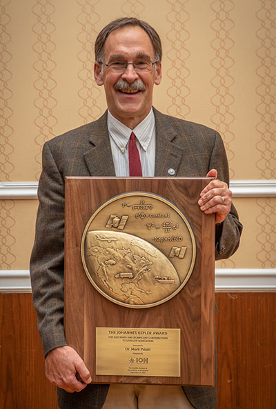
Mark Psiaki received the 2021 Johannes Kepler Award. (Photo: ION)
The Institute of Navigation’s (ION) Satellite Division presented two prestigious awards Sept. 24 at its ION GNSS+ 2021 Conference, which took place in St. Louis, Missouri.
Mark Psiaki received the Johannes Kepler Award for setting a standard of rigor, clarity and thoroughness in addressing key estimation and signal processing problems in positioning, navigation and timing (PNT).
The Johannes Kepler Award recognizes and honors an individual for sustained and significant contributions to the development of satellite navigation. It is the highest honor bestowed by the ION’s Satellite Division.
Psiaki originated the technique of bit-wise parallel RF signal processing for use in general-purpose processors. This enabler of software-defined GNSS led to the first space deployment of a fully software-defined GNSS receiver on a general-purpose digital signal processor (DSP) and to the widespread adoption of software-defined GNSS across the aerospace industry.
Psiaki’s real-time software radio expertise also enabled the development of a spoofer cultivated in his research group. He led the development of spoofing detection algorithms based on cross-correlation of unknown P(Y) codes and based on direction-of-arrival sensing.
Psiaki was the lead signal processing designer/analyst for the iGPS program that combined Iridium L-band downlink signals, GPS signals and inertial navigation system (INS) data to enhance GPS anti-jam capabilities. Recent work on navigation based on low-Earth-orbit (LEO) satellites fuses observables from an existing global communications constellation with INS and other sensor data to provide a backup to GPS.
Another contribution demonstrates how Doppler-based navigation could replace pseudorange-based navigation if implemented using a large LEO constellation.
Psiaki has made many contributions to the practice of modeling, estimation, and detection applied to GNSS, including the study of GNSS carrier phase modeling for space-based applications. His campaign to decode the GIOVA-A L1 BOC(1,1) PRN codes enabled Galileo receiver manufacturers to test their systems before the ESA published the codes. His group’s work on ionospheric scintillations led to the first commercially-available scintillation simulators.
Psiaki holds the Kevin T. Crofton Faculty Chair of Aerospace & Ocean Engineering at Virginia Tech. He studied at Princeton University, completing a B.A. in physics in 1979 (magna cum laude) followed by an M.A. (1984) and a Ph.D. (1987) in mechanical and aerospace engineering.
He is a past recipient of the ION’s Burka Award, its Tycho Brahe Award, and the Pride at Boeing Accomplishment Award. He is a Fellow of both the AIAA and the ION.
PARKINSON AWARD
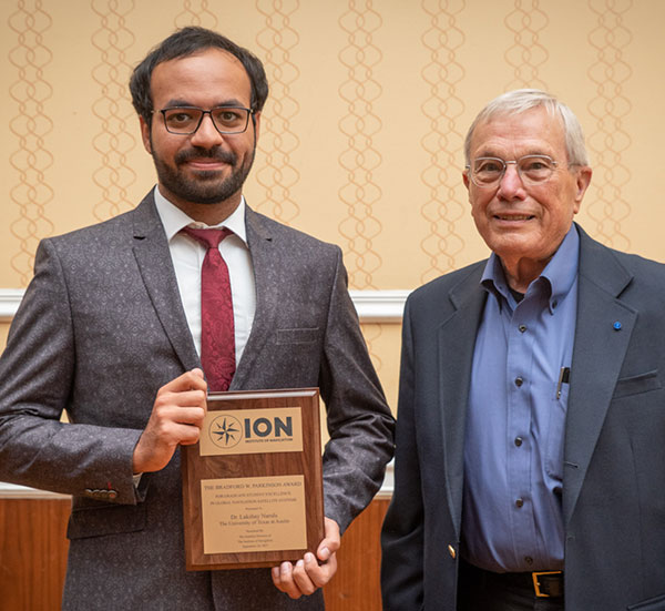
Lakshay Narula with Brad Parkinson. (Photo: ION)
The Institute of Navigation’s (ION) Satellite Division also presented Lakshay Narula with its Bradford W. Parkinson Award for his thesis, “Towards Secure & Robust PNT for Automated Systems.”
The Bradford W. Parkinson Award is given annually to an outstanding graduate student in the field of GNSS. The award, which honors Parkinson for his leadership in establishing both GPS and the Satellite Division of the ION, includes a personalized plaque and a $2,500 honorarium.
Any ION member who is a graduate student completing a degree program with an emphasis in GNSS technology, applications or policy is eligible for the award.