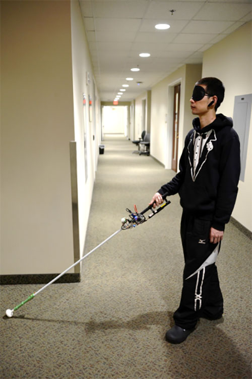
Study author Lingqiu Jin tests the robotic cane. (Photo: Cang Ye, VCU/NIH)
A new robotic cane can help the visually impaired navigate indoors. The cane is equipped with a color 3D camera, an inertial measurement sensor, and its own on-board computer.
When paired with a building’s architectural drawing, the device can accurately guide a user to a desired location with sensory and auditory cues, while simultaneously helping the user avoid obstacles like boxes, furniture and overhangs.
Development of the device was co-funded by the National Institutes of Health’s National Eye Institute (NEI) and the National Institute of Biomedical Imaging and Bioengineering (NIBIB). Details of the updated design were published in the journal IEEE/CAA Journal of Automatica Sinica.
“Many people in the visually impaired community consider the white cane to be their best and most functional navigational tool, despite it being century-old technology,” said Cang Ye, Ph.D., lead author of the study and professor of computer science at the College of Engineering at the Virginia Commonwealth University, Richmond. “For sighted people, technologies like GPS-based applications have revolutionized navigation. We’re interested in creating a device that closes many of the gaps in functionality for white cane users.”
While cellphone-based applications can provide navigation assistance — helping blind users stay within crosswalks, for example — large spaces inside buildings are a major challenge, especially when those spaces are unfamiliar.
Earlier versions of Ye’s robotic cane began tackling this problem by incorporating building floorplans; the user could tell the cane where he or she wished to go, and the cane — by a combination of auditory cues and a robotic rolling tip — could guide the user to the destination. But when used over long distances, the inaccuracies in the user’s location could build up, eventually leaving the user at an incorrect location.
To help correct this issue, Ye and colleagues have added a color-depth camera to the system. Using infrared light, much like a mobile phone’s front-facing camera, the system can determine the distance between the cane and other physical objects, including the floor, doorways and walls, as well as furniture and other obstacles. Using this information, along with data from an inertial sensor, the cane’s onboard computer can map the user’s precise location to the existing architectural drawing or floorplan, while also alerting the user to obstacles in their path.
“While some cell phone apps can give people auditory navigation instructions, when going around a corner for example, how do you know you’ve turned just the right amount?” said Ye. “The rolling tip on our robotic cane can guide you to turn at just the right point and exactly the right number of degrees, whether it’s 15 or 90. This version can also alert you to overhanging obstacles, which a standard white cane cannot.”
There are still a few kinks to be worked out before the system will be market-ready — it’s still too heavy for regular use, for example, and Ye’s team is looking for a way to slim down the device.
Nevertheless, with the ability to easily switch between its automated mode and a simpler, non-robotic “white cane mode,” Ye believes the device could provide a key independence tool for the blind and visually impaired, without losing the characteristics of the white cane that have stood the test of time.
The study was funded by NEI and NIBIB through grant EB018117.
Reference: Zhang H, Jin LQ, Ye C. “An RGB-D camera based visual positioning system for assistive navigation by a robotic navigation aid,” IEEE/CAA J. Autom. Sinica. 2021. 8(8):1389-1400. doi:10.1109/JAS.2021.1004084
Roscosmos plans to place GLONASS ground stations in Brazil, China, Indonesia, India and Angola, reports the TASS news agency.
“In the near future, another six non-request measuring stations are to be placed abroad: two in Brazil (Belem and Colorado de Oeste), one in China (Shanghai), one in Indonesia (Bukittinggi, West Sumatra), one in India (Bangalore) and one in Angola (Luanda),” the corporation said.
Negotiations with foreign partners have been held. On-site reconnaissance work has been carried out and contracts are being coordinated.
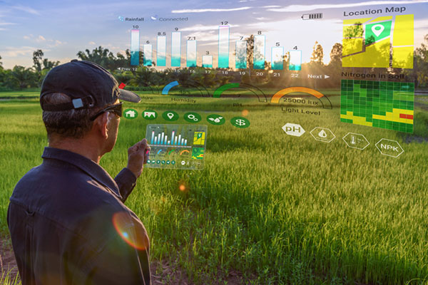
New Inmarsat research reveals a rapid increase in levels of industrial IoT maturity in 2021, with agricultural businesses accelerating IoT adoption in response to COVID-19
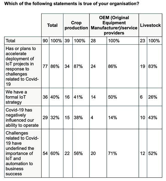
Research by Inmarsat, a global mobile satellite communications company, reveals a rapid increase in the maturity level of the industrial internet of things (IoT) across the agricultural sector since the start of the COVID-19 pandemic, with 86% of ag business accelerating or intending to accelerate deployment.
Respondents in the report, “Industrial IoT in the Time of COVID-19,” include crop producers, OEMs, service providers and livestock businesses, who report that COVID-19 demonstrated the importance of IoT to their businesses.
According to the research, adoption has seen huge progress from 2020 to 2021, with automation and cost savings the greatest drivers. Four-fifths (80%) of agricultural respondents have now fully deployed at least one IoT project, with 53% having achieved this in the 12-month period from the second quarter of 2020. Of the remaining 20% of agricultural respondents that have not yet adopted IoT in any form, all of them are either currently trialing it, or plan to deploy or trial at least one IoT project in the next two years.
Chart: Inmarsat
A further 86% of agricultural respondents indicated they have or they intend to accelerate the adoption of IoT in response to challenges related to COVID-19. This figure includes 46% who have already accelerated IoT adoption to respond to COVID-19, versus 29% who will accelerate over the next 12 months and 11% who will accelerate beyond the next 12 months.
The 46% that have already accelerated IoT adoption are less likely to state that COVID-19 has negatively impacted their ability to operate, demonstrating a link between IoT and business continuity during the pandemic. Additionally, more than half (60%) of respondents in the sector indicated that business and operational challenges related to COVID-19 have underlined the importance of IoT.
“We have seen agricultural producers take on more and more solutions that allow them to operate remotely, from autonomous irrigation control to the latest precision farming technologies, demonstrating increased faith in the technology,” said Steven Tompkins, Director of Market Development at Inmarsat.
As part of the research, Inmarsat is offering businesses the opportunity to measure their IoT readiness compared to the respondents in the survey, using their free IoT maturity tool.
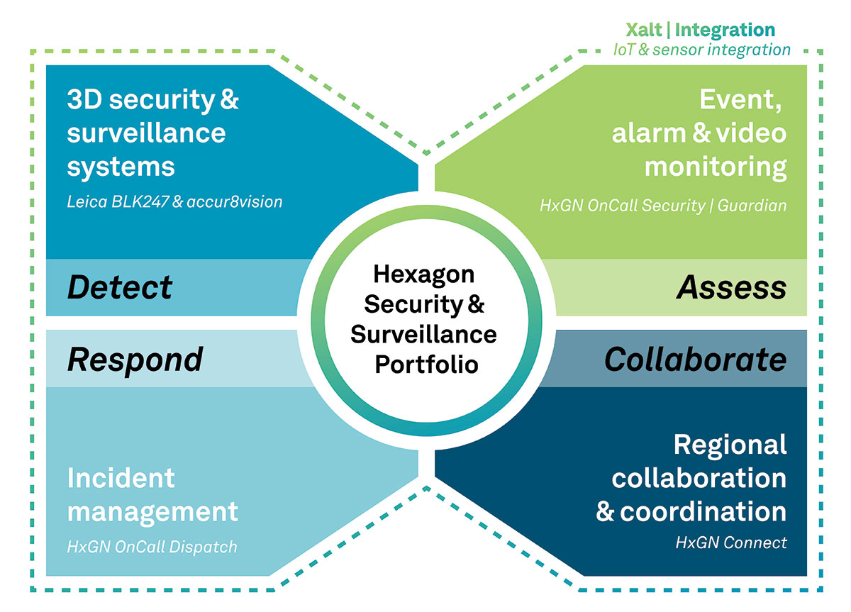
The Security & Surveillance portfolio for rail. (Image: Hexagon)
Hexagon’s Safety, Infrastructure & Geospatial division, in partnership with Hexagon’s Geosystems division, has introduced Hexagon’s Security & Surveillance portfolio for rail.
Comprised of an integrated set of solutions proven in rail operations around the globe, the portfolio unites 3D surveillance systems with best-in-class security, dispatching and collaboration software. It enables rail operators to better protect their assets, passengers and freight to reduce disruptions and improve safety and customer satisfaction.
The portfolio addresses the complete lifecycle of incident management, empowering operators to detect, assess and respond to threats and incidents and collaborate with outside organizations when needed. It includes:
Detect: Leica BLK247 and accur8vision 3D security and surveillance systems go beyond traditional 2D security cameras by integrating lidar, thermal sensors, video and 3D planning and tracking software for high-value areas, perimeters and zones, such as tunnels and rolling stock.
Assess: HxGN OnCall Security | Guardian provides a common operational picture for alarms, sensors, the internet of things, intrusion devices and video data to deliver situational awareness for real-time event monitoring.
Respond: HxGN OnCall Dispatch, a computer-aided dispatch solution with embedded assistive artificial intelligence, allows control room operators to dispatch resources to respond to incidents.
Collaborate: HxGN Connect facilitates collaboration and information sharing between internal teams and external entities to ensure stakeholders are informed and engaged during events.
“Globally, passenger and freight traffic are expected to double by 2050, which means rail operators must begin investing in safer rail operations now,” said Juergen Dold, President, GSI, Hexagon. “Rail networks have a broad spectrum of security needs, and Hexagon’s Security & Surveillance portfolio uniquely spans different hazards, capabilities and teams. It offers scalable solutions that seamlessly transition from simple security monitoring to emergency response to collaboration among diverse teams during complex operations.”
Hexagon’s Security & Surveillance portfolio builds on Hexagon’s capabilities for rail safety and security operations. Every year, Hexagon solutions protect more than 5 billion rail and transit passengers around the world. In North America alone, the company’s technologies help protect more than 56,000 miles of railways.
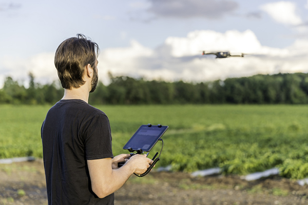
A Canadian drone pilot flies a UAV over a field. (Photo: Onfokus/iStock/Getty Images Plus/Getty Images)
360iSR and Canadian UAVs have agreed to jointly offer comprehensive unmanned aircraft system (UAS) operations training on the market globally.
The joint training offering leverages the partnership’s detect-and-avoid technology, which is available for multiple platforms and approved by Transport Canada, a branch of the Canadian government. The center will provide end-to-end UAS training solutions in alignment with NATO Standard ATP-3.3.8.1 requirements.
The initiative will provide access to comprehensive UAS operations training in these areas:
operational airworthiness
airmanship
general UAS information
detect-and-avoid systems and procedures
the integration of UAS in non-segregated airspace
intelligence, surveillance and reconnaissance (ISR) procedures.
Canadian UAVs is a Transport Canada registered training company with a proven track record providing UAV training to the Department of National Defense. The company has highly qualified UAS personnel who hold Transport Canada Advanced small RPAS Pilot Certificates (including those with Flight Reviewer ratings) and is authorized to provide beyond-visual-line-of-sight (BVLOS) UAS Operations Training at Foremost UAS Test Range in Foremost, Alberta, Canada.
360iSR offers end-to-end ISR support with an experienced team to deliver all aspects of ISR. 360iSR has worked on projects ranging from counter-poaching in Southern Africa to large-scale security events such as the London Olympic Games.
Applanix, a Trimble Company, has introduced new term licenses with full maintenance and support for its desktop post-processing software — POSPac Mobile Mapping Suite (POSPac MMS) and POSPac Unmanned Aerial Vehicles (POSPac UAV).
In addition, a new subscription for POSPac PP-RTX for UAV is also available.
The new licensing options lower the upfront investments required and enable customers to always have the newest features with updates included as part of the bundled maintenance and support.
The announcement was made at Intergeo 2021, a conference on geodesy, geoinformatics and land management, which took place this week in Hannover, Germany.
“The new licensing options for POSPac MMS and POSPac UAV provide our customers with maximum flexibility for acquiring full access to our industry-leading post-processing solutions. The options offer lower upfront initial investments and provide customers with full access to future releases and 24/7 customer support, as part of the included maintenance in the license agreements,” said Joe Hutton, Applanix’s Director of Inertial Technology and Airborne Products.
The new POSPac PP-RTX for UAV subscription is available with varying term lengths to accommodate user requirements. POSPac PP-RTX enables quick and easy data processing without a base station. The correction data is available within minutes after mission completion and requires a single button click in POSPac to launch. Customers will be able to process up to 30 minutes of dynamic data from the UAV platform.
The new licensing options and subscriptions are available now through the Applanix global sales channels.
NAVIGATION is a leading peer-reviewed and indexed scientific journal publishing articles on all areas related to the art and science of positioning, navigation and timing (PNT).
Printed paper copies of NAVIGATION will be discontinued beginning with the Spring 2022 issue. Instead, ION members will receive an environmentally friendly link to download a compiled electronic copy of each issue.
“Moving NAVIGATION to an open access domain is critical to supporting ION’s mission of advancing positioning, navigation and timing,” said Lisa Beaty, managing editor and executive director of ION. “Moving NAVIGATION to an OA platform will speed the delivery of timely PNT research, without the restrictions of paywalls or price barriers, to a worldwide audience. We want all scientists and engineers to be able to collaborate, analyze and build upon each other’s work for society’s common good.”
The NAVIGATION Editorial Advisory Board’s recommendation to the ION Council to move to an OA model is in keeping with the growing trend to broaden the impact and availability of scholarly research. OA has been shown to increase citations, increase readership, improve the quality of paper submissions, improve search engine prioritization, and increase a Journal’s Impact Factor (JIF). The ION Council approved this recommendation at its July 16 meeting.
The past two years of technical papers that have been published in NAVIGATION will now be available free through the ION website, and after Jan. 1, 2022, will be made available through numerous indexed and abstracted scientific bibliographic databases including:
Science Citation Index Expanded (Clarivate Analytics)
SciTech Premium Collection (ProQuest)
SCOPUS (Elsevier)
Technology Collection (ProQuest)
Web of Science (Clarivate Analytics).
NAVIGATION’s Open Access model will also be coupled with changes to ION membership. The Institute of Navigation will eliminate the price differential that was required to cover international mailing costs for members who reside outside the United States.
Professional membership will increase benefits to include 12 complimentary technical paper downloads per month — up from 12 per year — from ION’s extensive database of technical papers published in official ION conference proceedings. Students, Retired and Corporate Associate members will also now enjoy 12 complimentary technical paper downloads per month. Premium Professional Member downloads will double from 25 to 50 complimentary technical paper downloads per month.
Multiple leaders and technology experts from U.S. Army Futures Command are scheduled to speak at Fed Supernova 2021, an innovative defense technology conference that will take place online and at Austin’s Capital Factory Sept. 28-29.
Representatives from the command’s Army Applications Laboratory, Army Research Laboratory, Army Software Factory, Futures and Concepts Center, 75th Innovation Command and Austin-based headquarters will share insights on topics ranging from Joint Force software development initiatives to Army efforts to foster strategic industry partnerships that help bring promising new solutions to scale.
“Army Futures Command is dedicated to continuous innovation and broad collaboration. Events like Fed Supernova offer a unique opportunity for us to highlight recent wins while preparing for what’s next in the tech innovation space,” said Lt. Gen. Thomas Todd III, AFC deputy commanding general for Acquisitions and Systems and Chief Innovation Officer, who is scheduled to speak at the event.
A roundup of recent products in the GNSS and inertial positioning industry from the September 2021 issue of GPS World magazine.
OEM
Network Expansion
Provides precision timing over fiber
Photo: Huber+Suhner
Direct GPS-over-Fiber is a copper-free GNSS remote antenna that eliminates the need for costly power infrastructure. It uses power-over-fiber technology to distribute both the timing signal and power for the remote device. It is designed for telecommunication and data-center customers in need of scalable timing infrastructure solutions for outdoor remote antenna applications. It is fast and easy to install, with flexible, space-saving configurations that eliminate the need for power infrastructure at the remote end. The product makes network expansion achievable with a compact design and integrated transmitters, eliminating the need for multiple GPS antennas and maximizing the available space. It also extends the signal range between the antenna and the receiver.
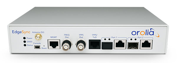
The cost-effective EdgeSync network timing platform provides NTP and PTP grandmaster and boundary clock functionality for real-time edge applications. High performance, scalability, ease of use and manageability make EdgeSync suitable for data centers, finance, mobile edge computing, enterprise, smart grid, industrial IoT, process control and telecommunications. EdgeSync uses a multi-GNSS receiver (GPS, Galileo, GLONASS, BeiDou and QZSS), PTP and Synchronous Ethernet as input references and generates PTP, SyncE, NTP and timing signals (10 MHz, 1 PPS and Time of Day message) as outputs. It also can provide IEEE 1588-2008 (PTP) grandmaster and boundary clock functionality and leverages unique PTP algorithms to deliver stringent timing for demanding, precise applications.
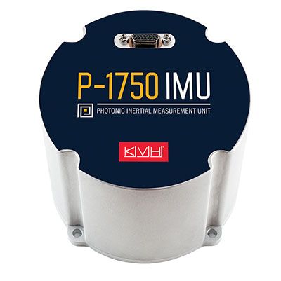
The P-1750 IMU and the P-1725 IMU complement the previously released P-1775 IMU to create a full line of IMUs with high-performance accelerometers and photonic integrated chip (PIC) technology. The P-series IMUs are offered in the same compact IMU housing design, and now offer more dynamic and accurate sensor performance, delivering improved navigation capability and more environmental robustness in vibration and shock capability for more challenging applications. PIC technology features an integrated planar optical chip that replaces individual fiber-optic components to simplify production and increase reliability. The accelerometers used in the P-series IMUs offer greater sensitivity and accuracy in their dynamic ranges. The IMUs are designed for challenging applications on land, sea and air, including autonomous trucks and people movers, drones, autonomous underwater vehicles and platform stabilization. Industries include transportation, military, agriculture, construction and mining.
The HC860 and HC860E active GNSS/Iridium antennas are designed for precise positioning, covering the GPS/QZSS-L1/L2, GLONASS-G1/G2, Galileo-E1 and BeiDou-B1 bands, including regional SBAS. The antennas also support active Iridium reception in the 1616.0-1626.5 MHz band. The HC860 housed and HC860E embedded helical antennas are designed for high-accuracy positioning. They are packaged in a light, compact form factor suitable for a variety of applications, including autonomous vehicle navigation (land, sea and air), handheld survey devices, automotive positioning, timing and other precise-positioning applications.
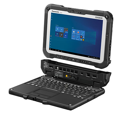
The Panasonic Toughbook G2 is a fully rugged 2-in-1 detachable tablet with optional keyboard that features an innovative modular design and user-removable expansion packs (xPAKs). With three modular expansion areas and up to 36 xPAK combinations, users can customize the Toughbook G2 to suit their needs with options including a 4G LTE-A multi-carrier with GPS or a dedicated U-blox NEO M8N receiver. The device is backward compatible with most Toughbook 20 and G1 docks. It has a 10.1-inch display, an Intel Core i5 and i7 vPro processor and runs on Windows 10 Pro. It has an 18.5-hour battery life. The 2-in-1 detachable design allows users to operate the device both in laptop and tablet modes.
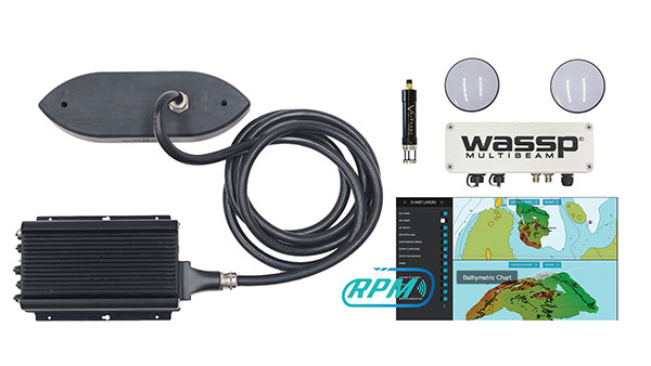
The WASSP S3r multibeam sounder combines data from a multibeam sounder transducer with 224 beams covering a 120° swath port to starboard along with position, heading and motion to create an accurate survey situations and environmental conditions. WASSP S3r is able to survey areas up to 10 times faster than a single-beam sounder. The S3r uses an SBG Ellipse-D Inertial Navigation System for its RTK + INS. The Ellipse-D allows the sounder to create accurately positioned 3D bathymetric representations of the seafloor, down to centimeter accuracy with minimal passes. WASSP has also incorporated the Ellipse-D into its S3Pr portable survey package. The SBG Ellipse-D was able to fit into a covered housing that allows quick setup on small vessels and interface with the WASSP DRX processing unit and CDX software. Ellipse-D integrates a dual-antenna, multi-band GNSS receiver, and is capable of delivering precise heading as well as centimeter-level position accuracy in challenging GNSS conditions.
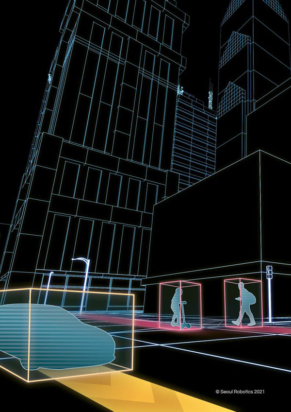
Voyage is a plug-and-play lidar perception system that delivers highly accurate object detection, tracking and classification capabilities. The deployment kit is equipped with SENSR2 software, lidar sensors and a lidar processing unit. Voyage provides volumetric profiling and motion-prediction capabilities, regardless of lighting conditions, and can collect and process data from up to four sensors for insights across the sensor coverage zones. Voyage does not capture, show or store any biometric and otherwise identifying data to maximize the protection of people’s privacy when installed as part of smart-city and security systems. The company’s sensor-agnostic perception software is available worldwide and is deployed by top-tier organizations such as BMW, Mercedes-Benz, the Chattanooga Department of Transportation and Emart, among others.
The TinySurveyor is a high-precision instrument for the surveying and infrastructure industries, able to execute large tasks up to 10 times faster than traditional methods. The machine pairs with a GNSS receiver to accomplish large-scale stake-outs, road pre-marking, as-built surveys and topographic surveys. Its ability to mark out existing data or collect new data at high speed and with high accuracy makes the TinySurveyor suitable for repetitive, time-consuming and labor-intensive tasks. With a GNSS receiver, repeatable results ensure accuracy of 1-2 cm. The TinySurveyor integrates with any GNSS receiver and has been tested with units from Topcon, Trimble and Leica.
Maptitude for Redistricting 2021 is a specialized tool for political redistricting that enables state legislatures, political and public interest groups, local governments and private citizens to create and advocate redistricting plans that meet their goals, adhere to legal requirements, and stand up to public scrutiny and legal challenges. Unlike a general-purpose GIS, Maptitude for Redistricting streamlines the plan creation process for all types of political boundary definitions and provides all of the calculations and reports needed. It is suitable for congressional redistricting as well as state legislative districts, city councils and local school board districts.
With the Luciad 2021 platform, defense, aviation, maritime and other organizations can develop effective and reliable web applications. LuciadFusion, an all-in-one server solution for geospatial data management, has two new types of data streaming, resulting in faster streaming of imagery and point cloud data. LuciadRIA supports Web Assembly to bring desktop-like calculations to the browser. Luciad 2021 also features enhancements to software development kits for desktop and on-board vehicle applications. LuciadLightspeed seamlessly integrates into JavaFX-based applications, making it easier to embed its map components into user interfaces, and now provides for high-resolution map printing. LuciadCPillar, an API for C++ and C# developers, was updated with labeling support and other new features.
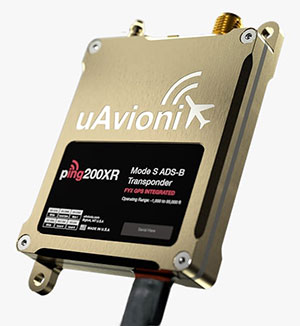
The Ping200XR integrates the capability of the Ping200X TSO Certified Mode S ADS-B OUT transponder with the high-integrity truFYX TSO-certified GPS position source into a single enclosure. The integration simplifies installation and allows the customer to choose between the installed GPS antenna or one provided with the Ping200XR. The integrated GPS ensures maximum safety by providing Source Integrity Level (SIL) 3 RTCA DO-229D and TSO-C145e Class Beta 1 performance, a requirement for Mode S and ADS-B airspace access, and for reception and processing by certified avionics and traffic collision avoidance systems in other aircraft as well as air traffic control. SIL 3 performance is not available from non-aviation certified GPS receivers, which often are used as an autopilot navigation source.
The RTL-450 lidar sensor incorporates a lightweight MEMS mirror and a precision navigation system to generate accurate data for demanding aerial surveying missions. The high-resolution, three-dimensional point clouds it creates enables operators to conduct advanced analytics of geographic and manmade features. Made in the United States, the RTL-450 incorporates patented lidar sensor technology. It weighs just over 4 pounds and is designed to operate independently of a drone platform, providing great flexibility for drone integration. Its modular design facilitates quick, efficient integration onto user-selected platforms.
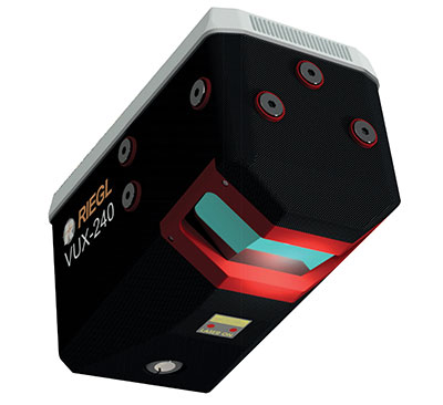
The RIEGL VUX-240 is a lightweight airborne laser scanner, especially designed for use on UAS/UAV/RPAS and small manned airplanes or helicopters. With its wide field of view of 75° and a data acquisition rate of up to 1.8 MHz, the instrument is suitable for high-point-density corridor mapping applications. The VUX-240 uses Riegl’s Waveform-Lidar technology, allowing echo digitization and online waveform processing. Multi-target resolution is the basis for penetrating even dense foliage. A continuously rotating polygon mirror wheel enables scan speeds of up to 400 lines per second, for efficiently covering large areas when operated from fast UAVs or aircrafts. The scanner stores 1 terabyte of data internally and is equipped with interfaces for an external IMU/GNSS system to control up to four external cameras.
The Carrier H6 Hybrid is a heavy-lift gas-electric hybrid drone powered by either the H2400 (Carrier H6 HE+) or H5000 (Carrier H6 HL) hybrid drone generator. The Carrier H6 Hybrid HE+ is equipped with the H2400 generator providing 2400W of continuous power. The recommended payload is 4 kg allowing for up to 2.5 hours of flight. The maximum payload of 6 kg allows up to 1.5 hours of flight. The Carrier H6 Hybrid HL has a maximum payload capacity of 15 kg and can be configured to carry more robust scientific-grade sensors, such as multispectral cameras, professional DSLRs for cinematography and lidar. The H6 Hybrid HL also can be used in heavy-lift applications involving asset transportation and delivery, agricultural spraying and search and rescue.
Harris Aerial, harrisaerial.com
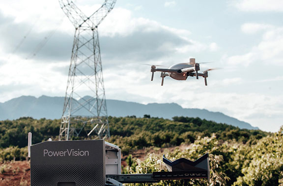
Industrial drone system
Autonomous ops from a dock
Photo: PowerVision
The PowerVision True Unmanned Aerial System combines the PowerEgg X 8K drone, PowerEgg Dock and the PowerVision Cloud web-based software platform. The integration provides a turnkey solution for remote, autonomous data-collection missions. With the system, drones can be deployed at scale as data-acquisition infrastructure, instead of tools to be operated on individual missions. Powered by artificial intelligence, the system streamlines the drone’s takeoff, flight, dynamic mission and return to the charging dock autonomously. The system weighs 34.8 pounds (15.8 kg) in a 570 x 400 x 250-millimeter form factor, allowing it to be deployed by a single person without special tools or equipment. The solution can be used for powerline inspections, environmental compliance, asset inspection, facility security, GIS, surveying and mapping.
The StarCourse service provides real-time extended ephemeris data for GNSS chipsets in connected mobile devices, giving them a headstart in determining position accurately and quickly. For devices with limited connectivity, typical extended ephemeris solutions have provided a headstart with 7¬–14 days of ephemeris data. StarCourse provides a 50% reduction in RAM requirements, 90% reduction in CPU cycles, and high location accuracy. Full data customization is provided to StarCourse subscribers, allowing them to create optimal solutions for their needs. The service enables autonomous positioning on connected GNSS IoT devices including asset tracking, wearables, in-dash navigation and mobile devices. For situations where accuracy is paramount, StarCourse Premium provides ultra-precise predicted ephemeris for the first 24 hours.
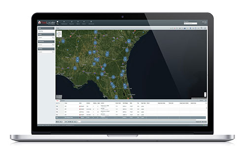
Trailer management solution FleetLocate captures data at the trailer level and translates it into actionable business intelligence to increase trailer productivity while reducing waste and costs. Telematics devices deliver core trailer insights that help automate yard checks and maximize use. Advanced trailer technologies are available, such as solar power management, tethered/untethered configurations, IntelliScan cargo sensing, cargo image capture and retrieval, door sensors, liftgate battery monitoring and more.
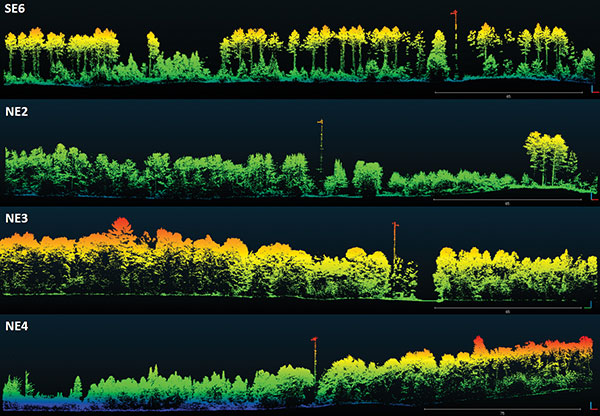
A specialist team at the University of Wisconsin-Madison (UW-Madison) used the Routescene UAV lidar system to detect and visualize forests in Northern Wisconsin, United States, as part of the CHEESEHEAD project. The objective of the project is to improve weather forecasting by understanding how vegetation and forests influence the atmosphere. This information will be used by decision makers to develop policies that more effectively enable carbon emission reductions.
Project overview
The CHEESEHEAD project (The Chequamegon Heterogeneous Ecosystem Energy-balance Study Enabled by a High-density Extensive Array of Detectors) studies interactions and feedback between the land surface and atmosphere and how these results can be used to improve weather and climate models. Ultimately, the results will enable better carbon-emission reduction policy making.
Visualization of dominant tree structures in Northern Wisconsin around the flux towers. (Image: Routescene)
The UAV Lidar Surveys
The UW-Madison team collected high density 3D point-cloud data of the prominent tree species in Wisconsin’s Chequamegon-Nicolet National Forest. Routescene’s drone-mounted lidar system captured the full tree structure, from the tree canopy to ground-level vegetation.
UAV lidar works well to quickly and efficiently survey and represent the type, shape and composition of a forest canopy. Surveys were carried out around eleven 100-foot flux towers within areas that ranged from 0.25 km² to 1 km². Six forest types were identified that included aspen, pine, poplar, larch, cedar and hardwood.
“The tall canopy of 20–30 m height created difficult flying conditions,” said Christian Andresen, UW-Madison. “It was difficult to keep a visual line of sight, so we decided to fly smaller 500 m x 500 m flights to keep sight of the drone.”
The Routescene lidar system includes a 32-laser lidar sensor providing a scan rate of up to 1.4 million points per second. Point-cloud density averaged 600 points per meter squared with a vertical accuracy of 2–5 cm.
“The Routescene system worked flawlessly and we achieved all we had planned. Over the three days, our crew of two covered a total of 4.2 km²,” Andresen said. “We were particularly impressed with the density of overlapping flight lines and the mapping of the forest structure.”
This project contributed to the wider CHEESEHEAD experiment to generate knowledge that advances the science of surface flux measurement and modelling, relevant to many scientific applications such as numerical weather prediction, climate change, energy resources and computational fluid dynamics.
Of the hundreds of papers researchers presented at 2020’s annual Institute of Navigation (ION) GNSS+ conference, which took place virtually Sept. 21–25, the following six focused on combating jamming and spoofing. The papers are available at www.ion.org/publications/browse.cfm.
Using Direction of Arrival
The author presents a scheme to combine multiple measurements for GNSS spoof detection for safety-of-life applications. The author’s algorithm combines both independent and correlated direction of arrival measurements that result in an analytic solution for the detection threshold, which can be computed online by the receiver. The scheme is validated for correlated azimuth measurements with data recorded by a dual-polarization antenna mounted on a C12 aircraft in flight, and applied to data from a live spoofing event. Results show an increase in detections of 47% using just two sequential measurements, with equal robustness for false alerts compared to snapshot-based detection. The results also show using sequential spoof detection is a powerful way to improve the detection capability of an anti-spoof defense, costing only added computational complexity while introducing a timely component to the detection.
Citation. Rothmaier, Fabian; “Optimal Sequential Spoof Detection Based on Direction of Arrival Measurements.” https://doi.org/10.33012/2020.17538
Using Neural Networks
Spoofing attacks are difficult to model and counteract. Data-driven schemes become useful if enough training data is available. This article explores such an approach using the cross-ambiguity function delay/Doppler map as input to a deep neural network for classification purposes. Several neural network models are trained, and their performance compared for detection and false-alarm probabilities. Results are promising, particularly with more complex neural networks, which are able to capture the nature of spoofing attacks. The method operates on a per-satellite basis.
Information cross-validation can be a powerful tool to detect manipulated, dubious GNSS timing data. Opportunistic time providers, Wi-Fi beacons and dedicated timing infrastructures provide largely available, precise sources of time information. A promising approach is to leverage time obtained over networks to which a mobile device can connect, and detect discrepancies between the GNSS-provided time and the network time. The paper investigates different options to secure augmentation time information, notably Network Time Security (NTS) and modified Wi-Fi beacons to support authentication. This scheme requires limited overhead, does not disrupt the normal operation of the Wi-Fi access points, and can be readily deployed.
Citation. Spanghero, Marco; Zhang, Kewei; Papadimitratos, Panagiotis; “Authenticated Time for Detecting GNSS Attacks.”
Using Cooperative Positioning
This paper highlights possible metrics to be checked to identify malicious attacks to the positioning and navigation systems in mass-market connected devices. The network-based exchange of GNSS data — such as GNSS raw measurements recently disclosed in Android smart devices — could offer the possibility to compare or combine such metrics to better identify spoofing and meaconing attacks.
This paper provides experimental tests and analysis toward devising an anti-spoofing strategy in connected GNSS devices. Included are a classical spoofing approach (simplistic RF attack) and its effects on the raw GNSS observables. With two synchronized devices in a cooperative framework, possible metrics are highlighted to identify a spoofing attack to one of the devices by observing anomalies.
Also included is work on simulated meaconing of an already-developed collaborative positioning framework based on the exchange of raw GNSS measurements through the network. The different approaches of an attack to the framework are laid down, and the anomalies to be considered to detect an attack in a network of cooperating devices are presented.
This paper represents a part of a larger goal to develop an anti-spoofing detection and coping mechanism in connected commercial GNSS devices.
Citation. Rustamov, Akmal; Gogoi, Neil; Minetto, Alex; Dovis, Fabio; “GNSS Anti-Spoofing Defense Based on Cooperative Positioning.”
Using OSNMA in the GIANO GNSS receiver
In recent years, the awareness about jamming and spoofing risks has been increasing, particularly in the timing community because they may cause the disruption of critical services and infrastructures in the telecommunication, energy and finance sectors, which rely on GNSS timing to operate. To overcome these hazards, the European GNSS Agency (GSA) has funded the development of timing receivers for professional applications, with the aim to address specifically the above vulnerabilities, improving the receiver’s robustness and the accuracy and reliability of time transfer.
In this context, the GIANO (Galileo-based timing receiver for critical infrastructures robustness) project consortium, coordinated by Thales Alenia Space Italy and with the support of Deimos Engenharia S.A. (Portugal), the Space Research Centre PAS in Poznan (Poland), Piktime System SP. Zoo (Poland) and Business Integration Partner S.p.A. (Italy), has been awarded a contract in the framework of the GSA’s “Fundamental Elements” program to develop a timing receiver for critical infrastructure applications. Besides the implementation of some interference and spoofing detection and mitigation techniques, the GIANO receiver makes use of Galileo’s authentication service OSNMA (Open Service Navigation Message Authentication), which can be employed as an added defense against some types of spoofing.
OSNMA exploits the TESLA (Time Efficient Stream Loss-tolerant Authentication) scheme, which is a protocol based on the transmission of message authentication codes generated with a key broadcast with some delay. The receiver authenticates the satellite messages through a digital signature algorithm and a public key known by the receivers, which also validates the root key of the TESLA chain, and through message authentication codes (MAC) used to authenticate specific fields of the navigation message. The receiver will also support public key renewals over the air.
This paper presents the OSNMA implementation within GIANO receiver, including the cryptographic operations required. The GIANO OSNMA capability will be extensively tested and validated with the support of the European Commission Joint Research Centre (Ispra, Italy).
Chimera is a signal authentication enhancement suitable for protecting the L1C GPS signal. As specified by the acronym itself (chips-message robust authentication), Chimera is based on the insertion of authentication features both at the message and spreading code levels. The data are digitally signed, while the spreading code is protected by the insertion of cryptographically generated punctures.
The Chimera interface specification document was made public in 2019, while its first transmission is expected to be broadcast from the Navigation Technology Satellite 3 (NTS-3) satellite, set for launch in 2023.
This paper describes the software implementation of the functions required to enable a GNSS software receiver to elaborate the Chimera authentication service. It includes a description of the development work and a detailed software profiling analysis, allowing for evaluation of the additional computational burden required by the Chimera verification and useful for providing important guidelines for receiver implementation.
“Seen & Heard” is a monthly feature of GPS World magazine, traveling the world to capture interesting and unusual news stories involving the GNSS/PNT industry.
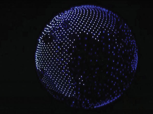
Screenshot: Global News video
Our Spinning Globe
A highlight of the opening ceremony at the Tokyo 2021 Olympics was a revolving globe above the Olympic stadium. The 1,824 Intel Shooting Star 3 drones formed a complex set of geometrical shapes before transitioning into the games’ emblem, and then a 3D representation of Earth. The Intel Shooting Star 3 drones are designed for entertainment purposes. Each drone weighs 340 grams, is equipped with four extremely bright LEDs, and features real-time kinematic (RTK) GPS for the increased positional accuracy needed for high-resolution animations, sharp imagery and dynamic 3D animations.
Illegal coffee plantations have appeared inside Bukit Barisan Selatan National Park in Indonesia, a key habitat for the endangered Sumatran tiger and other species. Conservationist Matt Leggett noticed in satellite images the declining size of the forest, and sent a team of researchers on an undercover operation on dirt bikes with cameras and GPS receivers, reports the Aug. 11 New York Times Magazine. Leggett’s team mapped hundreds of small coffee farms and investigated the complex chain of custody, which ends with major brand names. No solution has been found, though some farmers have promised to replant the forest over the next 15 years, while others continue to clear park land.
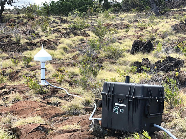
Seven scientific-grade GPS stations are joining a network of 65 that the USGS Hawaiian Volcano Observatory operates on the Hawaiian Islands. As Hawaiian volcanoes erupt and grow, they add weight to the Earth’s surface, causing the Pacific Plate to flex downward and possibly causing the shelf to splinter. Earthquakes this spring in Hawaii likely were related to weight on the underlying crust and mantle from eruptions. Collecting years of data from these stations should help scientists better understand motions of the Pacific Plate, according to researcher Jeff Freymueller, Michigan State University. The first three GPS stations were installed in May; others are being installed this summer.
Nikon could be launching a consumer camera equipped with GNSS instead of only GPS, providing a major upgrade for the geolocation coordinates provided with photo metadata. Filings with the governments of Russia and Indonesia describe a camera dubbed N2014, which will be equipped with GNSS as well as Wi-Fi and Bluetooth. A number of Nikon CoolPix digital cameras have built-in GPS, while other cameras — Nikon D-SLRs and select Nikon 1 — can use optional accessory GPS devices.