Author: Tracy Cozzens

  • Beyond Gravity delivers key payload components for ESA’s Celeste

    Beyond Gravity delivers key payload components for ESA’s Celeste

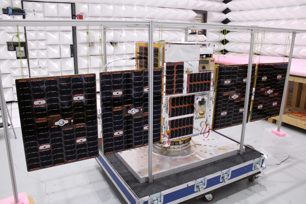
    Beyond Gravity has delivered key payload components for the ESA’s Celeste project aimed at making existing satellite navigation systems more accurate and resilient. The first demo satellites were launched into space on March 28. Beyond Gravity wants to further extend its payload offerings.

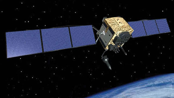
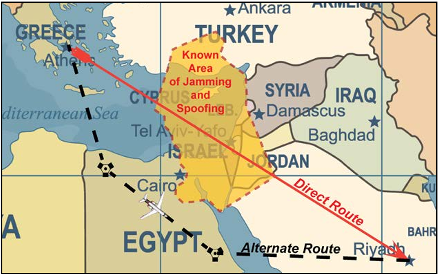
    The European Space Agency (ESA) is embarking on a demonstration mission of 11 satellites in orbit to test and demonstrate the benefits of an additional layer of PNT (positioning, navigation and timing) in low Earth orbit. This will further improve the accuracy and responsiveness of Europe’s satellite navigation system, even during jamming and spoofing attacks. Celeste demonstrates how this additional layer can complement the resilience, security and precision of the European navigation system Galileo.

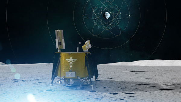
    The first two demonstration satellites of the new Celeste navigation mission were launched into space on March 28.

    “Key electronics for the Celeste satellite payload are provided by Beyond Gravity,” said Oliver Grassmann, chief operating officer at Beyond Gravity. “Expanding our payload capabilities is a top priority, as we continue to deliver high‑performance solutions for diverse missions — including radio occultation, reflectometry, electronic signal intelligence, and positioning, navigation, and timing.”

    Kurt Kober, vice president, Electronic Solutions at Beyond Gravity, highlights the company’s key contributions to Celeste. “We play an important role in this mission and supply cutting-edge technology for digital signal generation and the clock for the satellite instruments,” Kober said. “These components ensure high reliability of the navigation signals as well as time accuracy and stability.”

    Apart from the payload components, the company also supplied highly sensitive antennas. ESA has chosen Beyond Gravity as a key payload partner for Celeste alongside the Spanish space company GMV (prime contractor) and OHB in Germany.

    Making Galileo more secure

    The new Celeste navigation satellites in low Earth orbit will demonstrate how an additional layer in a low-earth orbit around 500 km could complement the larger Galileo navigation satellites at an altitude of around 23,000 kilometers and make them more secure. This new satellite mission is known as Celeste, ESA’s first initiative in Low Earth Orbit PNT (LEO-PNT).

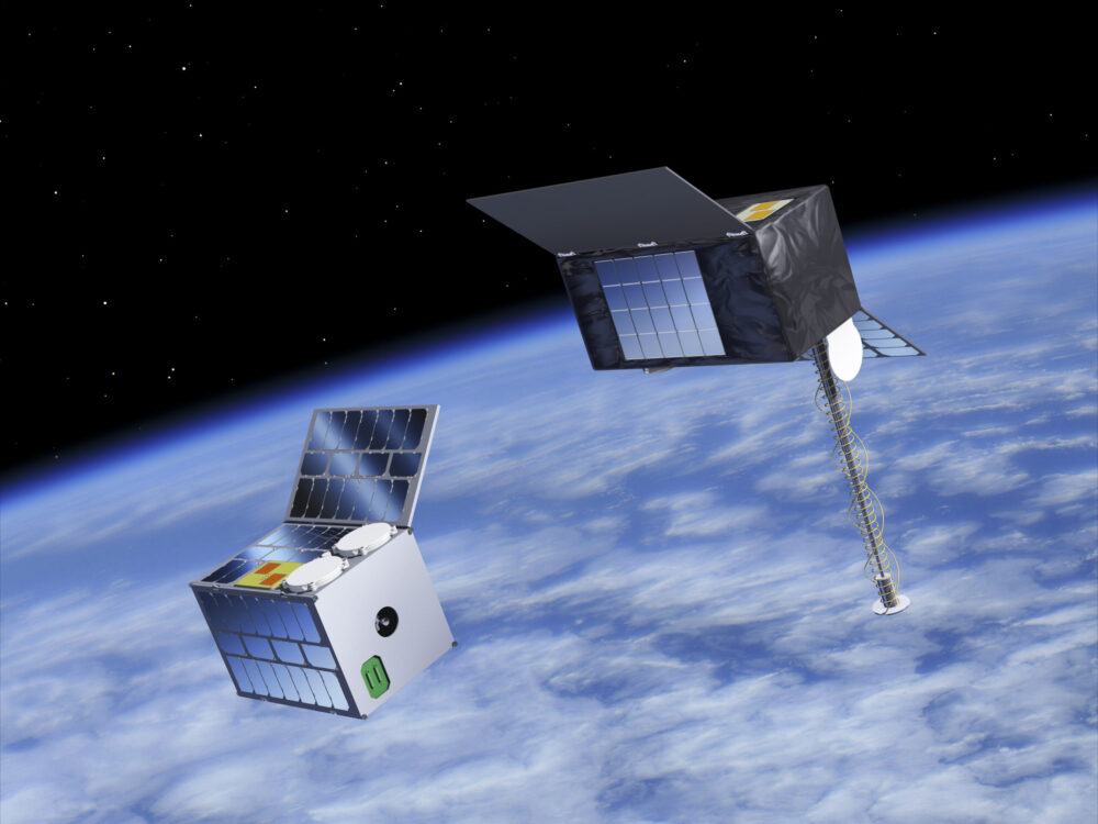
    The in-orbit demonstrator phase for Celeste is being executed by two European consortiums in parallel and will comprise a total of 11 satellites plus one spare. GMV, as one of the prime contractors, is responsible for the complete end-to-end mission, including system definition and design, the space and ground segments, the user segment and operations, for 6 of the demonstrator satellites.

    Importance of satellite payloads

    The payload comprises those elements of a satellite that perform its actual task, in the case of Celeste the creation and transmission of navigation signals. “We have already delivered important satellite instruments, like our radio occultation weather instruments, and a reflectometer payload,” Kober said. “We also supplied payload elements in the field of signal generation for the European satellite navigation system Galileo. This expertise has been incorporated into the Celeste project.”

    Kober sees satellite payloads as an important area for future business. “We want to play a greater role in this core area of satellites, the payload.”

    Modular payload solution

    With its FoX electronics platform, Beyond Gravity offers a flexible and modular solution that can host different payloads. Examples for such possible payloads include electronic signal intelligence (ELINT), which can be used for detecting and characterizing radar signals, or a PNT (positioning, navigation, timing) payload.

    Other possible payloads from Beyond Gravity are its radio occultation and reflectometry instruments as well as high-resolution earth observation images (optical payload from a third-party supplier).

    The FoX electronics platform, together with the payloads selected for the customer, can be easily integrated into Beyond Gravity’s satellite platform (multi-purpose platform), which successfully passed its Preliminary Design Review and is now undergoing intensive tests.

  • ESA’s Celeste IOD-1 satellite transmits first navigation signal

    ESA’s Celeste IOD-1 satellite transmits first navigation signal

    Celeste will test a complementary low-Earth-orbit layer for Galileo for more robust and accurate navigation.

    At 10:38 CET on April 8, the Celeste IOD-1 satellite, developed by GMV and Alén Space under the European Space Agency’s (ESA) Celeste In-Orbit Demonstrator (IOD) program, successfully transmitted its navigation signal for the first time.

    The reception of the signal from the Celeste IOD-1 satellite, confirmed by ESA teams at ESTEC, marks a key milestone for the program as it confirms the satellite’s successful commissioning in orbit. The signal was also received at GMV’s monitoring station in Lisbon.

    The first two IOD satellites of the Celeste program — built by GMV and Thales Alenia Space, respectively — were launched March 28 at 10:14 CET from Rocket Lab’s Launch Complex 1 in Mahia, New Zealand. Separation from the launch vehicle took place one hour later, marking the start of the initial operations phase (LEOP) and commissioning, carried out by GMV for the IOD-1 satellite from the mission control center in Tres Cantos.

    Next-generation LEO navigation

    Celeste is ESA’s strategic program to demonstrate the benefits of an additional low Earth orbit (LEO) navigation layer that complements Galileo and EGNOS, with the goal of improving the accuracy, resilience and security of positioning, navigation and timing (PNT) services in Europe.

    The in-orbit demonstrator (IOD) represents the program’s first phase and will validate key LEO-PNT technologies in flight ahead of potential future operational deployment.

    The Celeste IOD phase is being carried out in parallel by two European consortia and will include a total of 11 satellites plus one in-orbit spare. As one of the prime contractors, GMV is responsible for the end-to-end mission for six of the demonstrator satellites, including system definition and design, the space and ground segments, the user segment, and operations.

    Celeste program beginnings

    The Celeste program began with two demonstrator satellites, IOD-1 and IOD-2, aimed at securing registered frequency allocations and testing representative navigation signals through the end of the year. The mission will demonstrate precise autonomous orbit determination without relying on ground infrastructure, as well as stronger radionavigation signals in the L- and S-bands from low Earth orbit.

    By demonstrating the advantages of integrating LEO capabilities into a multi-orbit architecture alongside Galileo (MEO), Celeste aims to improve resilience to interference and expand advanced navigation services. Operating at altitudes between 500 and 560 km, the Celeste demonstrators will assess how a complementary LEO layer can enhance Europe’s Galileo system in medium Earth orbit.

    Eight additional, larger satellites are currently under development to extend the capabilities of the initial demonstrators. These will form part of the full fleet (eleven operational spacecraft and one spare) and will pave the way for subsequent launches starting in 2027.

    GMV was selected in 2024 by the European Space Agency (ESA) to lead one of the parallel contracts for the development of Celeste. The first satellite in the constellation, a 12U CubeSat named Celeste IOD-1, was jointly developed by GMV and Alén Space.

    In recent months, Celeste IOD-1 has undergone a complex assembly and integration process, as well as rigorous environmental and system testing. The results of these tests, carried out at GMV’s facilities, confirmed that the satellite was ready for launch, as well as for initial LEOP (Launch and Early Orbit Phase) operations and in-orbit experimentation activities.

  • Net Insight leads development of next-generation PNT technology

    Net Insight leads development of next-generation PNT technology

    Focusing on timing synchronization, the project is supported by ESA NAVISP on behalf of the Swedish National Space Agency to advance resilient timing and positioning.

    Net Insight has been awarded a development project through the European Space Agency’s Navigation Innovation and Support Program (NAVISP), a European program designed to foster innovation in the PNT domain and strengthen Europe’s technological competitiveness. 

    The project, co-funded by the Swedish National Space Agency, aims to accelerate the development of robust positioning, navigation and timing (PNT) technology, to address growing societal needs and increase risks to critical infrastructure.

    Precise timing signals are a critical component of everything from telecommunications and 5G networks to transportation and energy systems. Traditionally, GNSS systems such as GPS and Galileo have been the standard for time synchronization. However, today’s geopolitical landscape and the increasing prevalence of disruptions such as jamming and spoofing highlight the need for robust, complementary solutions that can ensure reliable operation under all conditions, according to Net Insight.

    “This initiative exemplifies how the Swedish space industry can contribute to addressing complex European challenges related to critical infrastructure,” said Christer Nilsson, vice director general of the Swedish National Space Agency. “Combining Swedish technical excellence with European collaboration is a powerful model for strengthening robustness and operational reliability within PNT.”

    “Society depends on technologies that are not only advanced, but also robust and operationally reliable, and capable of withstanding disruptions and external interference,” said Per Lindgren, group CTO and head of synchronization at Net Insight. “With this project, we are strengthening the development of solutions that can deliver reliable time synchronization even under demanding conditions, thereby securing critical infrastructure for the future.”

    Through collaboration with the Swedish National Space Agency and ESA’s NAVISP program, the project gains access to both national and European funding and support for research and development in PNT technology. At the same time, it enables national initiatives to be aligned with broader European strategies for robust and operationally reliable PNT architectures.

    NAVISP is designed to stimulate new technologies and applications beyond traditional GNSS-based systems and plays a key role in Europe’s efforts to ensure robust and competitive PNT solutions.

  • Lockheed Martin secures $105M contract for GPS IIIF operations

    Lockheed Martin secures $105M contract for GPS IIIF operations

    Lockheed Martin has received a potential $105 million firm-fixed-price task order from the U.S. Space Force’s Space Systems Command to supportGPS IIIF launch and on-orbit testing.

    The award covers services related to the Architecture Evolution Plan (AEP) operational control system. This includes support for launch, early orbit operations and eventual disposal of GPS IIIF satellites (space vehicles SV11-22). The effort is part of ongoing work to sustain and manage next-generation positioning, navigation and timing capabilities for military users.

    Work under the sole-source task order will take place in Colorado Springs, Colorado, through March 2030. The contract is managed by SSC’s satellite communication and PNT office at Peterson Space Force Base. SSC obligated $13.4 million from fiscal 2026 research, development, test and evaluation funds at the time of award.

    Lockheed Martin’s previous contracts supporting the GPS IIIF program include a nine-year, $1.36 billion contract in 2018 to produce the 11th and 12th GPS IIIF satellites, and a $509.8 million contract modification for GPS IIIF space vehicles 21 and 22 granted in May 2025. SV-21 and SV-22 are expected to be delivered by November 2031.

  • GPS III ground control contract held by RTX could be canceled

    The U.S. Space Force is considering canceling the contract held by RTX (formerly Raytheon) to develop the GPS III ground control system, according to a report in Air & Space Forces Magazine.

    GPS OCX, the Next-Generation Operational Control Segment, has long been beleagured by cost overruns and deadline delays. Established in 2010, the GPS OCX program was planned to begin operations in 2016. In 2010, Raytheon (now RTX) was contracted to develop a modernized ground control system to support the upcoming GPS Block III satellite constellation.

    The first GPS III satellite, built by Lockheed Martin, launched in 2018. Eight more have followed, with the 10th satellite awaiting launch on a SpaceX Falcon 9 rocket within the next few months. With 32 GPS satellites on orbit, the Space Force is relying on the OCX software to utilize the advanced GPS III capabilities for jam-resistance and precise navigation.

    In July 2025, RTX began a government-led testing phase, but the tests revealed software defects.

  • SWF: GNSS interference a key issue for space security

    The Secure World Foundation’s annual report, “Global Counterspace Capabilities: An Open Source Assessment,” is now available.

    The 2026 edition compiles and assesses publicly available information on counterspace capabilities being developed by 13 countries across five categories: co-orbital, direct-ascent, electronic warfare, directed energy and cyber.

    The report discusses jamming against GNSS and other position, navigation and timing (PNT) satellites. It assesses current and near-term future capabilities for each country, along with their potential military utility, and discusses their space situational awareness capabilities.

    Countries covered in this report are: the United States, Russia, China, India, Australia, France, Germany (added this year), Iran, Israel, Japan, North Korea, South Korea, and the United Kingdom.

    Download the report here.

  • FAA updates GNSS Interference Resource Guide

    FAA updates GNSS Interference Resource Guide

    The U.S. Federal Aviation Administration (FAA) has updated its GNSS Interference Resource Guide with updated information on GNSS vulnerabilities and general edits throughout.

    The FAA’s Flight Technologies and Procedures Division (AFS-400) developed the guide to provide U.S. operators and pilots with the most current information regarding GPS and GNSS jamming and spoofing.

    According to the guide’s introduction, “The impacts of safety hazards from GNSS interference rapidly spread over the past few years and is persistent. As the threat of GNSS jamming and spoofing is constantly changing, the FAA will update this resource guide to provide the best guidance in the rapidly changing environments.”

    Download the guide here.

  • Unifly & Nexova complete NAVISP phase to advance cyber-resilient U-space operations

    Unifly & Nexova complete NAVISP phase to advance cyber-resilient U-space operations

    Unifly, in cooperation with Nexova, have successfully completed the SecureUTM 2 Phase I under the European Space Agency’s (ESA) NAVISP program, with emphasis on mitigating GNSS jamming and spoofing.

    The project establishes a certification-aligned, risk-driven cybersecurity foundation for secure, resilient and scalable unmanned traffic management (UTM) and U-space services across Europe. 

    As drone operations grow in complexity and cross-border interoperability, cybersecurity is becoming essential for operational continuity and public trust. SecureUTM 2 embeds cybersecurity engineering into the core architecture of UTM systems, aligning with European U-space regulations, Common Criteria methodology and ENISA risk frameworks. Security is treated as a foundational design principle rather than a late-stage compliance requirement. 

    Building on SecureUTM 1, SecureUTM 2 Phase I significantly expanded the cybersecurity baseline for UTM systems. Key outcomes include: 

    • Refinement of a harmonized Protection Profile (PP) for UTM 
    • Development of an updated Security Target (ST) for the Unifly platform 
    • Structured risk assessment and certification-aligned gap analysis 
    • Definition of a secure architectural baseline addressing real-world U-space complexity 
    • Setup of a PoC Testbed 

    Risk-based engineering roadmap

    A control-by-control gap assessment translated cybersecurity requirements into a prioritised implementation roadmap. Focus areas include: 

    • PNT source authentication and plausibility checks 
    • Enhanced session integrity and transport protection 
    • Denial-of-Service resilience 
    • Device-level authentication and auditing 
    • Secure storage and encryption 

    This structured approach supports operational deployment and future EU cybersecurity certification readiness. 

    Validated mitigations for GNSS and PNT threats

    SecureUTM 2 phase I placed strong emphasis on GNSS jamming and spoofing risks increasingly observed in drone operations. Practical, layered mitigations were validated through a dedicated U-space proof-of-concept testbed with Hardware-in-the-Loop UAV simulations. 

    Validated measures include: 

    • On-board GNSS jamming detection 
    • Fleet-level interference inference 
    • Trajectory plausibility and conformance monitoring 
    • OSNMA-based message verification 
    • Structured anomaly logging and alerting 

    The testbed enables repeatable attack simulation, KPI-based evaluation and regulator-ready evidence generation. 

    Foundation for Phase II and European deployment

    Phase I also delivered a structured U-space testbed blueprint, verification methodologies and digital twin foundations to support continued validation, operator training and continuous cybersecurity testing. 

    SecureUTM 2 directly supports Belgium’s U-space deployment strategy and strengthens its position in secure drone integration. 

    Phase II will focus on implementing prioritised controls, expanding validation capabilities and further aligning with EU certification frameworks. 

  • Advanced GNSS ionospheric sensor sent into orbit

    Advanced GNSS ionospheric sensor sent into orbit

    The U.S. Naval Research Laboratory (NRL) has successfully launched the GNSS Orbiting Situational Awareness Sensor (GOSAS), one of three advanced experimental payloads.

    GOSAS was aboard the Space Test Program’s (STP) Satellite-7, which launched at 4:33 a.m. PDT on April 7 from VandenbergU.S. Space Force (USSF) Base, California.

    The other payloads are the Lasersheet Anomaly Resolution andDebris Observation (LARADO) instrument and the Gadolinium Aluminum Gallium Garnet (GAGG) Radiation Instrument (GARI-1C).

    GOSAS will improve the reliability of navigation and communication systems for warfighters.

    “The GOSAS is a CubeSat-compatible, programmable dual GPS receiver designed to characterize the orbital GNSS environment and produce high-quality ionospheric space weather products,” said Scott Budzien, PhD, NRL research physicist and GOSAS principal investigator. “Understanding and predicting space weather is critical for ensuring the accuracy of GPS and the integrity of military communications.”

    GOSAS is a follow-on to the NRL experiment GROUP-C (GPS Radio Occultation and Ultraviolet Photometry-Collocated) experiment on the International Space Station that took place 2017-2023 and serendipitously detected GPS ground interference.

    GOSAS originated in 2020 with the mission of increasing GPS accuracy for the warfighter.

  • Galileo’s LuGRE proven for Moon navigation

    Galileo’s LuGRE proven for Moon navigation

    With the first manned Artemis mission to the Moon underway, the European Space Agency reminds us it has already accomplished testing of a GNSS receiver for Moon missions.

    News from the European Space Agency

    In 2025, history was made as a navigation receiver on the Moon determined its position in real time using signals from approximately 410,000 km away. The receiver, called the Lunar GNSS Receiver Experiment (LuGRE), acquired signals from four navigation satellites orbiting Earth: two Galileo satellites and two GPS satellites.

    The mission also tested Galileo’s Emergency Warning Satellite Service (EWSS) on the Moon, demonstrating the robustness and reach of the planned service.

    With an increasing number of lunar missions planned by space agencies and private companies in the coming decades, accurate lunar navigation will be a key component of sustainable lunar exploration and the development of a lunar economy.

    LuGRE, the joint Italian Space Agency (ASI) and NASA mission, showed that existing terrestrial satellite navigation systems can be used for positioning, navigation and timing on the Moon. Transported to the Moon by Firefly’s Blue Ghost, LuGRE was the first navigation receiver to operate beyond low Earth orbit.

    After arriving at the Moon on March 2, 2025, LuGRE maintained connections with Galileo and GPS satellites, in double frequency, for a lunar day (14 Earth days) before powering down. The success of LuGRE laid a foundation for future navigation systems on the Moon by demonstrating the feasibility of using navigation satellites orbiting Earth to determine positions on the Moon.

    Emergency warning on the Moon

    In early March 2025, Qascom, the company that developed LuGRE for ASI, proposed an additional joint demonstration to test the Galileo EWSS on the Moon during the LuGRE mission. This demonstration involved ESA, the European Commission (EC), the European Union Agency for the Space Program (EUSPA) and the Centre National d’Etudes Spatiales SAR Galileo Data Service Provider (CNES/SGDSP).

    With less than two weeks from proposal to execution, the partners swiftly coordinated their efforts to make the demonstration possible. 

    On March 13, 2025, a simulated emergency warning message alerting astronauts to seek shelter due to high radiation exposure was disseminated via select Galileo satellites and received by LuGRE’s receiver on the Moon as part of the data collected and downloaded to Earth.

    LuGRE was the idea candidate for this off-world test because it was designed to receive navigation signals. The emergency warning message of the EWSS is sent via the same signal frequency as satellite navigation signals, so LuGRE was also able to pick up and process the EWSS test signal.

    The success of this demonstration on the Moon showcases the robustness and reach of the Galileo EWSS, which will enter service later this year. It also highlights the collaboration between European institutional and industrial partners, a strong example of cross-agency collaboration enabling innovation in global navigation services.

    Stepping towards lunar navigation

    With lunar exploration expected to increase in the coming years, ESA’s Moonlight program is developing navigation and telecommunications services for use on the Moon. By providing a unified lunar navigation and communication system, Moonlight will allow missions to focus on core activities, facilitating a long-term presence on the Moon and exploration of the Moon and beyond. Due to its compatibility with other planned lunar navigation systems, Moonlight will increase the future lunar service provision for many institutional and private users.

    Newly approved at ESA’s Ministerial Council in 2025, NovaMoon will develop the first station on the Moon for high accuracy navigation. It will enhance the navigation services of Moonlight by providing an advanced geodetic and timing station on the Moon.

  • Survey to determine highest mountain peak in Bangladesh

    Survey to determine highest mountain peak in Bangladesh

    A government-sponsored survey has set out to find the highest peak in Bangladesh. Field teams for the Survey department under the Ministry of Defense have begun field work in the remote hill areas of Ruma and Thanchi upazilas in Bandarban district.

    The survey, taking place April 4-12, will use modern geodetic methods and advanced GNSS technology. The surveyors will follow international standards to determine the height of the country’s highest peak above mean sea level (MSL) with centimeter-level accuracy, including latitude, longitude, and elevation.

    Through the use of a newly developed geoid model, it will be possible to accurately convert ellipsoid heights obtained from GNSS receivers into mean sea level (MSL) elevations of the mountain peaks, according to the government.

    The survey is expected to resolve the long-standing debate over whether Tajingdong, Keokradong or Saka Haphong is the country’s highest mountain peak.

  • Mikroe offers XSens MTi-8 Click board for RTK GNSS and INS

    Mikroe offers XSens MTi-8 Click board for RTK GNSS and INS

    XSens MTi-8 Click is a new compact add-on board designed for RTK-supported high-accuracy positioning and orientation tracking in demanding outdoor embedded applications. It is based on the MTI-8-5A, an RTK-enhanced GNSS/INS module from Xsens that combines GNSS positioning with advanced inertial sensing and real-time sensor fusion.

    The compact Click add-on boards enable developers to rapidly provide proof-of-concept, then prototype and code new embedded projects. 

    Key Features

    • Centimeter-level precision: Features real-time kinematic (RTK) support, delivering position accuracy down to 1 cm + 1 ppm CEP
    • High-speed sensor fusion: Runs the Xsens’ sensor fusion algorithm with output data rates up to 100 Hz, providing high-speed dead-reckoning and orientation data even during rapid movements
    • Advanced inertial sensing: Integrates a high-range gyroscope, accelerometer, and magnetometer, offering roll/pitch accuracy of 0.5° RMS and yaw accuracy of 1° RMS (with GNSS aiding)
    • Interface options: Offers flexible system integration through UART, SPI, or I2C interfaces, along with a USB Type-C port for easy configuration and testing.

    Suitable applications

    • Self-driving platforms and delivery robots that require centimeter-level navigation in outdoor environments
    • Autonomous tractors and crop-monitoring drones where precise path-following is essential
    • High-end drones and robotic systems that depend on accurate roll, pitch, and yaw data for stability
    • Mobile mapping systems and surveying equipment that demand high-reliability motion tracking and positioning.

    The board is now available from Mikroe.