Joint venture between DroneDash and Geodnet targets oil palm, sugarcane and broad-acre operations across Southeast Asia, the United States and South America.
DroneDash Technologies and Geonet are forming Geodash Aerosystems Pte. Ltd. — a Singapore-incorporated joint venture to develop a new class of agricultural spraying drone for large-scale, industrial farming operations. Commercial deployment is set for Q3 2026.
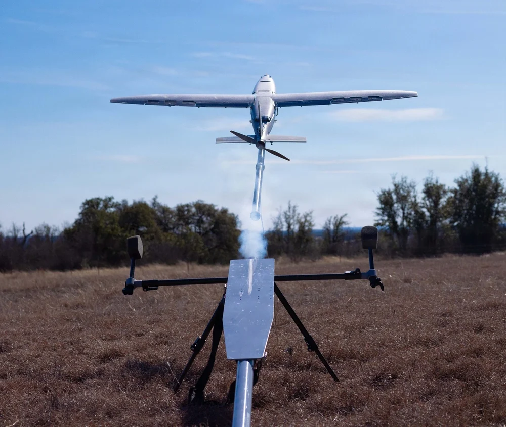
Unlike conventional agriculture drones that require repeated manual pre-mapping before each deployment, Geodash Aerosystems’ platform uses real-time AI vision and centimeter-accurate RTK positioning to perceive, navigate, and adapt dynamically during flight. The result is faster deployment, lower operating costs, and continuous agronomic intelligence from the same system that does the spraying.
Credit: DroneDash
Most agricultural spraying drones in operation were adapted from general-purpose UAV platforms. Before each deployment, operators must manually survey and map the field, generate static flight plans, and repeat the entire process whenever terrain, planting patterns, or canopy profiles change. In oil palm plantations and large-scale row-crop environments, this mapping overhead directly limits how many hectares a team can cover and how quickly they can respond to emerging crop conditions.
The operational constraints are compounded the larger the estate. Manual pre-survey and field mapping is required before each deployment. Static flight plans must be recreated when terrain or canopy profiles change. Plans have limited adaptability to uneven terrain and mixed-age crops, when erosion or other changes occur.
Geodash Aerosystems’ drone architecture removes pre-mapping from the deployment workflow entirely. Using DroneDash’s proprietary AI vision system, the aircraft performs real-time perception of plantation structure, canopy height, and terrain features during flight. Geodnet’s RTK correction network delivers centimeter-level positional accuracy throughout each mission.
This combination enables:
deployment without pre-mapping or manual mission surveys
dynamic interpretation of rows, trees and operational zones
continuous altitude and spray-rate adjustment over variable terrain
rapid redeployment after replanting or field reconfiguration
tree-level and zone-specific variable-rate application.
Situational awareness is generated dynamically during flight — not through a separate pre-deployment process. Each aircraft maintains geofencing controls, safety constraints, and full operational data logging for regulatory compliance and audit traceability.
Agronomic Intelligence Layer
Each GEODASH Aerosystems drone is integrated with DroneDash’s AI Smart Farming backend, which transforms every operational flight into a continuous data-collection activity. Spraying missions generate field data used to produce:
canopy density and uniformity analysis
crop stress and anomaly detection
zone-level health scoring
spray effectiveness validation
terrain and drainage profiling
historical trend analysis across blocks and seasons.
Backend AI analytics then deliver actionable decision support to plantation managers and agronomy teams: early indicators of pest, disease, or nutrient stress; identification of underperforming zones; optimized spray timing and dosage; and data-informed planning for replanting and fertilization. The drone functions as a continuous aerial intelligence layer, not a standalone spraying machine.
Geodash Aerosystems targets industrial agriculture markets where deployment speed, terrain adaptability, and precision matter most: oil palm plantations in Southeast Asia; sugarcane, soybean and corn operations in the United States; and palm, sugar and broad-acre estates in South America.
Pilot deployments and system validation have been conducted throughout 2025 and into early 2026 in collaboration with plantation operators. Commercial deployment is targeted for Q3 2026, following completion of manufacturing readiness and regulatory approvals.
Deepen AI has released its latest targetless calibration platform, built to simplify and accelerate calibration for complex autonomous vehicles, automotive ADAS and robotics sensor suites.
The platform supports a wide range of configurations including GNSS receives, multiple lidars, radars, cameras and inertial measurement units (IMUs). It processes all inputs in one pass using a single continuous dataset such as a ROS bag.
As sensor stacks become more sophisticated, traditional calibration methods are increasingly becoming a bottleneck in deploying autonomous systems at scale. These approaches are often manual, iterative and dependent on physical targets. Deepen AI’s solution introduces a fully automated and unified approach that calibrates all sensors simultaneously.
The platform estimates intrinsic, extrinsic and temporal parameters across the entire sensor suite in a single streamlined workflow, removing the need for sensor-by-sensor calibration. This approach streamlines operations while delivering high performance, achieving up to 0.05° angular accuracy and 0.7 cm positional accuracy, exceeding traditional target-based calibration techniques.
Capabilities include:
Simultaneous calibration across all sensors using a single dataset
Support for multi LiDAR, camera, radar, IMU, and GNSS configurations
Accuracy of up to 0.05° and 0.7 cm
No strict requirement for loop closure or fixed driving patterns
“Calibration has traditionally been one of the most time-consuming, complex and fragmented steps in deploying autonomous systems,” said Mohammad Musa, founder and CEO of Deepen AI. “With this release, teams can move to a system level approach that delivers both speed and precision using real-world data.”
The system is designed to work without controlled environments or rigid data collection protocols, allowing teams to seamlessly integrate calibration into existing workflows for both research and large-scale production deployments. It requires only simple and practical conditions, with calibration possible in locations such as parking lots, garages or quiet streets, provided the environment is mostly static with minimal moving objects. A minimum of 30 seconds of continuous driving data is required.
The platform is already being deployed with customers working on highly complex sensor configurations, where multiple lidars and cameras need to be calibrated together as a single system. In one such deployment, the full sensor stack was calibrated during a normal drive in a parking garage, parking lot, or a small residential street, without any special driving patterns or looped trajectories.
Using only a short duration of driving data, Deepen AI simultaneously performed intrinsic, extrinsic and temporal calibration across all sensors in a single workflow. This unified approach not only simplifies operations and improves consistency, but also delivers accuracy that surpasses traditional target-based calibration methods, making it well suited for both research and production environments.
The Indian government has approved development of an indigenous, runway-independent combat search-and-rescue UAV for the Indian Air Force.
The drone will be used to rescue pilots and crew, and deliver supplies in extreme terrains, tasks to be accomplished without risking manned aircraft. For instance, snowbound heights are difficult for helicopters to traverse.
The UAV will be developed under the government’s Make-I category with 70% funding, and will operate up to 16,000 feet in the air. It will carry payloads up to 400 kg and support autonomous missions within a range of 200 km and a 45-minute loiter time.
New 95G and 250G accelerometers and 4000°/sec gyroscope ranges deliver navigation solution integrity in high-dynamic environments, supporting interceptors, missiles and hypersonic platforms.
VectorNav Technologies has announced 95G and 250G accelerometer and 4000°/sec gyroscope ranges across its Tactical Series inertial measurement unit (IMU) and inertial navigation system (INS) product line.
The enhancement directly addresses urgent requirements from defense contractors and platform developers operating in high-G mission profiles.
Defense modernization priorities are accelerating procurements of interceptors, missiles, and hypersonic platforms that must operate through launch, interception, and aggressive maneuvering — often in environments where GPS is denied or degraded. In these conditions, navigation performance depends on the IMU’s ability to maintain solution integrity without saturating.
The extended-range Tactical Series is designed to meet that requirement, providing the core inertial measurements that enable resilient position, navigation, and timing (PNT) solutions to operate through mission-critical flight phases where conventional sensors fail.
“The demand signal from our customers has been unmistakable,” said Jakub Maslikowski, VP of Business Development. “As platforms become faster, more maneuverable, and face increasingly sophisticated threats, high-performance inertial navigation solutions are needed at scale to meet the evolving demand. With nearly 20 years supporting these mission profiles, we know these applications—and the extended-range gyro and accelerometer will enable faster integration and more rapid fielding of reliable systems.”
The extended-range accelerometer and gyroscope are available across the full VN-110 IMU and VN-210 / VN-310 INS product family, supporting applications including:
high-speed interceptor platforms
rapid-response strike systems
hypersonic and advanced maneuvering vehicles
counter-UAS and air defense systems
next-generation precision guidance
The extended-range configurations are drop-in compatible with existing platforms — no changes to form, fit or function — enabling immediate upgrades without redesign.
Anello Photonics and Q-CTRL have entered a strategic partnership to develop resilient navigation solutions for unmanned aerial vehicles (UAVs) operating in environments where GPS is degraded or unavailable.
The collaboration focuses on integrating Anello’s Silicon Photonics Optical Gyroscope (SiPhOG) technology with Q-CTRL’s Ironstone Opal quantum magnetic navigation capabilities. This integration creates a multi-layered quantum navigation solution (QNS) designed to provide continuous, bounded positioning estimates that do not degrade over the course of a mission. By combining silicon photonics-based inertial sensing with quantum-powered magnetic map matching, the companies aim to provide a critical backup to GNSS.
Reliability in satellite navigation has become a significant concern across both defense and commercial sectors. Vulnerabilities such as jamming and spoofing pose a documented $1B daily threat in the United States, impacting logistics, transport, and military operations. Recent disruptions in the Persian Gulf have further highlighted the challenges faced by maritime and aerial platforms when GNSS signals are compromised.
The initiative represents the first time these two specific technological approaches have been integrated to scale quantum navigation solutions. As electronic warfare evolves and the use of autonomous systems expands, the ability to operate without a constant GPS signal is becoming a standard requirement for next-generation mobility and mission-critical platforms.
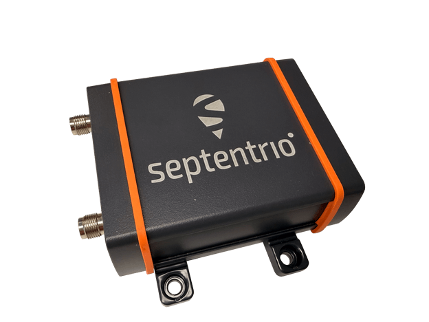
Septentrio, part of Hexagon, offers a new enclosed multi-frequency GNSS receiver: AsteRx EB.
The cost-effective product offers uncompromised high-accuracy positioning and GNSS heading for industrial robots, port logistics, marine, and scalable automation applications. Its IP67 enclosure protects the receiver from harsh weather conditions, while built-in advanced GNSS+ algorithms ensure reliable operation in environments that are challenging for GNSS, such as areas with foliage or near GNSS interference sources.
The RAIM+ integrity monitoring system ensures truthful positioning, which is essential for autonomous navigation. The compact enclosure of AsteRx EB enables easy installation, reducing time-to-market.
“AsteRx EB is an ideal boxed receiver for customers who need reliable, resilient, and highly accurate positioning in a compact form factor and at a price point that makes rapid scale-up possible,” said Danilo Sabbatini, Product Manager at Septentrio, part of Hexagon.
In a dual-antenna configuration, AsteRx EB delivers sub-degree GNSS heading for systems that require orientation in addition to RTK positioning. The built-in AIM+ anti-jamming and anti-spoofing technology protects the receiver from intentional or unintentional GNSS interference.
AsteRx EB extends Septentrio’s lineup of enclosed GNSS receivers. Like mosaic-go, it can be used for quick and easy testing or evaluation of Septentrio’s reliable positioning technology. Thanks to its robust housing, it can be deployed in a wide range of industrial applications. For systems exposed to very harsh weather conditions or intense mechanical stress, the AsteRx RB3 ultra-rugged receiver provides the highest level of protection.
As GPS World readers know, the growing prevalence of GPS/GNSS jamming and spoofing outside of conflict zones interrupts vital aviation safety technologies and presents challenges to maritime commerce and the global economy. An alarming example is playing out along the Baltic Sea and the North Sea, prompting 13 coastal European nations and Iceland to highlight in January 2026 “growing GNSS interference” and collectively reinforce requirements to comply with existing regulations and international law designed to ensure the safety of all maritime vessels engaged in shipping.
As commercial aircraft report navigation anomalies and maritime operators experience false position data in congested waterways, global authorities are sounding alarms that GNSS interference will continue to rise without immediate action. In March 2025, the International Civil Aviation Organization (ICAO), International Telecommunication Union (ITU), and International Maritime Organization (IMO) issued a joint warning expressing “grave concern” that disruptions from GNSS jamming and spoofing constitute an urgent threat to public safety, telecommunications networks and international commerce.
Compounding harmful interference incidents led the GPS Innovation Alliance (GPSIA) to act. Defeating illegal and harmful interference outside of combat zones requires a coordinated, whole-of-government strategy that focuses on stopping bad actors through deterrence and enforcement, and directing resources toward preventing and sanctioning those violating international commitments and laws prohibiting jamming and spoofing. Investing in GPS modernization and integrating innovative signals from complementary PNT satellite systems into devices and receivers will deliver PNT that surpasses today’s technologies to the global community.
Roadmap for Action
In September 2025, GPSIA led a coalition of leading industry groups in sending a letter to the Departments of Defense and Transportation that called for urgent action to address GPS jamming and spoofing. We noted the United States has the technology and expertise to solve this issue, and the administration has the power to act. GPSIA followed the letter with a whole-of-government strategy providing a clear roadmap for the administration. While some recommendations have been implemented, other opportunities remain.
Focus on the Real Culprits
The culprits in each of these scenarios are bad actors putting public safety and global commerce at risk with harmful interference outside conflict zones. The global community relies on several unique technologies that can be impacted by harmful interference, such as cellular and Wi-Fi signals, radars and automated information systems. The misplaced focus on faint GNSS signals or dependencies on GNSS derail collective efforts to immediately regain interference-free global commerce and bolster public safety.
Governments and international organizations mandate certain industries integrate safety-of-life technologies into their operations — and they do, at great cost. Officials should in turn be given the political support and resources to stop bad actors from intentionally interfering with them.
What to Do Next
Public and continued diplomatic engagement are critical. By amplifying European counterparts, condemnations from senior U.S. officials can raise the reputational costs for bad actors and reaffirm international norms that protect GNSS signals and other technologies from harmful interference.
Engaging with the ICAO is important. The U.S. should reinforce its commitment to providing modern civil GPS signals that support navigation in international airspace and encourage ICAO to prioritize the enforcement of global GNSS protections.
GPSIA also recommends Executive agencies establish an interagency task force that rapidly identifies and disseminates information about interference events with civil operators, including sanitized intelligence information on intentional jamming and spoofing of commercial aircraft and ships.
Civil operators also should be invited to participate in interference coordination calls and reporting. Sharing radio-frequency interference data, incident reports and threat assessments among military and civil agencies and operators is essential to preserving public safety. The Performance-based Operations Aviation Rulemaking Committee’s recommendations for continuity of operations during GPS disruption events should continue to be implemented with urgency.
The GPS III satellite has additional anti-interference features. (Image: Lockheed Martin)
Deterrence and information sharing must be coupled with sustained enforcement. Federal agencies have taken welcome action to interdict illegal jamming equipment, reporting an 830% increase in seizures since 2021. We applaud the U.S. government for prioritizing resources to stop the illegal import and sale of these devices.
GPSIA commends the Kingdom of Norway’s annual Jammertest, which allows receiver and device manufacturers to test interference detection and counter jamming and spoofing. These realistic test scenarios, together with strengthened enforcement and prioritized intelligence collection and analysis, will enhance public safety.
Modernize GPS
While GPS satellites continue operating with an extraordinary 99.99% availability and no outages on record, the health of the constellation and jamming and spoofing incidents affecting receivers and devices, demand action. The final GPS III satellite is scheduled to launch this spring. Next-generation GPS IIIF satellites are being built. Their launches should be prioritized to reduce the number of satellites on orbit that are one system or subsystem away from failure. GPSIA welcomed the passage of the FY2026 Defense Appropriations Bill, which bolstered national and economic security by investing needed funding for modernized GPS IIIF satellites and long-term PNT leadership.
Notably, the current GPS program plan does not include counter-spoofing technologies. Implementing counter-spoofing authentication capabilities for Wide Area Augmentation System (WAAS) signals would further strengthen aviation resilience.
Ground infrastructure modernization is equally important. The GPS ground station must be able to command and monitor GPS III and IIIF satellites and the modern L5 aviation signal.
Streamline Regulatory Activities
Regulatory modernization represents another area of progress. In September 2025, the State Department removed jam-and spoof-resistant Controlled Reception Pattern Antennas (CRPAs) from the International Traffic in Arms Regulations (ITAR), fulfilling one recommendation from GPSIA’s strategy.
Certification processes also must evolve, and integration of CRPAs into aircraft should be accelerated. The modern L5 signal and counter spoofing signal authentication signals must be incorporated into FAA-certified and other receivers as soon as possible.
Recommendations for the FCC
President Trump’s December 2025 Executive Order (EO), “Ensuring American Space Superiority,” directs U.S. departments and agencies to detect and counter threats to U.S. space infrastructure. It also states that his administration will enable industry to develop and deploy advanced space capabilities, including terrestrial and cislunar PNT applications. This EO should serve as a “North Star” for the FCC, resulting in increased enforcement resources to address illegal jamming and spoofing, and a regulatory environment prioritizing innovative, advanced commercial satellite PNT systems that complement GPS. Demonstrating American leadership in space demands that we step forward, not backwards, in our PNT capabilities.
The FCC is evaluating the record developed in its Notice of Inquiry, Promoting the Development of PNT Technologies and Solutions, and is reportedly considering future rulemaking. The FCC’s task is not to replace GPS, but to ensure that the regulatory environment protects its spectrum, increases enforcement actions against those perpetuating harmful interference and enables innovation that complements this foundational system. This balanced approach will fulfill President Trump’s mandate, preserving public safety and economic security, and ensure continued American leadership in PNT.
Global Safety and Commerce
Baltic and North Sea shipping lanes have become a flashpoint for GPS jamming and spoofing, prompting 13 European nations and Iceland to issue a joint warning in January 2026 over interference threatening maritime safety and global commerce. (Photo: Dmitri Toms / iStock / Getty Images Plus / Getty Images)
The FCC’s Notice of Inquiry uncovered dozens of PNT technologies, ranging from those in the marketing stage, to hyper-localized solutions, to proposals to exploit “signals of opportunity.” Creativity and ingenuity abound in the commission’s record, but the docket’s many filings lacked technical details to evaluate whether the systems advance the nation’s PNT leadership.
The hallmarks of GPS are its worldwide coverage, and the continuity, availability, integrity and accuracy of its signals. Our modern global community deserves complementary PNT systems and signals that meet or exceed GPS capabilities. A few satellite-based solutions stood out as holding promise to do so.
Systems operating in low-Earth orbit (LEO) can transmit stronger signal power due to their proximity to Earth, improving performance in urban environments and contested spectrum conditions. Systems operating in different frequency bands, such as TrustPoint’s C-band system, add spectral diversity, making it far more difficult for an adversary to disrupt all PNT services simultaneously. When combined with modernized GPS signals and authentication capabilities, this layered approach can deliver robust services while complementing the foundational role of GPS.
Terrestrial systems cannot replicate global coverage of satellite constellations. They are also vulnerable to wildfires, hurricanes and other disasters.Building parallel terrestrial networks would require significant investment while delivering a fraction of modernized satellite systems’ capabilities. Nor do terrestrial signals provide the continuity, availability, integrity and accuracy of satellite systems.
The Progress is Real
GPSIA is pleased to report that progress is being made in several areas outlined in its “whole-of-government” strategy. It’s time to accelerate that progress. In May 2026, GPSIA members will convene to evaluate this strategy and outline what more the PNT industry can do to play a part in defeating harmful interference. Our members also will meet with government officials to underpin that government-led enforcement and solutions to jamming and spoofing can further illustrate the importance of PNT to U.S. leadership in space, and national security, public safety and the global economy.
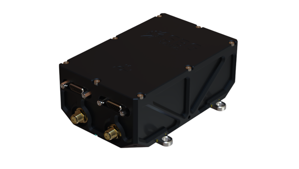
SBG Systems has expanded its product line with the launch of the Stellar-40, a modular and scalable inertial navigation system (INS) designed for demanding environments and mission-critical applications.
Designed for land, air and marine platforms, the Stellar-40 integrates a tactical-grade IMU, a GNSS receiver and advanced sensor fusion algorithms within a compact and rugged enclosure. The system is designed to provide reliable navigation performance in high-vibration, high-dynamics and electronically challenging environments.
The development of the Stellar-40 focused on two main objectives: increasing resilience in harsh operational conditions and improving production scalability. To overcome the vibration sensitivity commonly encountered in defense and industrial applications, SBG Systems implemented an innovative three-level mitigation approach:
Sensor-level isolation: Dampers integrated directly at the IMU sensor level reduce vibrations at the source.
Resonance-free enclosure: A specialized housing engineered to drastically minimize resonance and internally induced vibrations.
Structural isolation: Custom external dampers designed to isolate the unit from harsh vehicle dynamics.
This architecture supports stable system behavior in dynamic environments.
Beyond mechanical robustness, the Stellar-40 addresses modern electronic warfare challenges. The system incorporates a high-performance GNSS receiver designed to actively mitigate advanced jamming and spoofing threats. When GNSS signals are degraded or unavailable, the system relies on multi-sensor fusion and dead-reckoning capabilities to maintain navigation continuity.
Positioned as the heavy-duty counterpart to the Ekinox Micro, the Stellar-40 introduces a revised mechanical and electronic design intended to simplify integration and manufacturing processes. The system is suited for defense programs, robotics platforms, UAVs and autonomous systems requiring compact, scalable navigation solutions.
“Stellar-40 was developed with scalability and integration flexibility as key priorities,” said Kaoutar, product manager at SBG Systems. “The design aims to support a broad range of platforms while keeping large-scale production in mind. This product brings high-end resilience against vibrations, jamming and spoofing into a box that teams can completely trust in real-world operations.”
With the introduction of the Stellar-40, SBG Systems continues to expand its range of inertial navigation solutions for professional and industrial applications.
The Stellar-40 is designed for a wide range of applications across defense and autonomous systems. It supports platforms such as UAVs, robotics and other autonomous vehicles that require compact and scalable navigation solutions. Its revised mechanical and electronic design simplifies integration and manufacturing, making it well-suited for both large-scale production programs and demanding operational environments.
The world is rapidly filling with connected devices. IoT Analytics reports that 18.5 billion IoT devices were online in 2024, with growth accelerating toward an expected 21.1 billion by the end of 2025 and 39 billion by 2030. As artificial intelligence drives demand for richer, more precise device data, the need for reliable, high‑accuracy positioning becomes foundational.
Yet today’s GNSS infrastructure — including cellular-based real‑time kinematic (RTK) networks — was never designed for this scale. Billions of devices — from vehicles to drones to industrial sensors — depend on location data, but the traditional GPS model struggles under three converging pressures: (1) massive device growth, (2) rising accuracy requirements, and (3) increasing vulnerability to interference.
These pressures are reshaping expectations for positioning, navigation and timing (PNT) and creating demand for a new, more resilient delivery model.
Why Accuracy and Resilience Matter More Than Ever
Autonomous systems are the clearest example of the accuracy challenge. Xona Space Systems CTO Dr. Tyler Reid notes that safe autonomous driving requires 10 cm accuracy 95% of the time and 30 cm accuracy at “eleven nines” reliability. Standard GPS, accurate only to several meters, cannot meet these thresholds — even with traditional enhancement techniques.
At the same time, GNSS signals face growing threats. Spoofing and jamming events are now daily occurrences in parts of Europe, and U.S. federal agencies increasingly require contract bidders to incorporate resilient PNT technologies alongside legacy GNSS.
Finally, the explosion of IoT devices introduces a network‑scale challenge. Many of these devices could benefit from high‑precision positioning, but continuous unicast RTK streams are not an efficient use of cellular networks, especially as billions of devices come online.
Together, these factors point to a simple conclusion:
A new delivery model for high‑precision GNSS corrections is needed — one that is accurate, resilient, and scalable.
Why a Hybrid Approach Is Required
RTK positioning is the gold standard for centimeter‑level accuracy. It works by combining GNSS signals with correction data from a known base station. However, traditional RTK has two major limitations:
Coverage constraints — corrections must be delivered within a limited range of the base station due to the fact that accuracy diminishes the further the GNSS base is from the rover.
Network constraints — corrections are typically delivered over cellular networks, which become inefficient at scale.
Precise Point Positioning (PPP‑RTK) can extend range and reduce dependency on local base stations, but today’s PPP‑RTK implementations are proprietary and lack a common standard.
To support billions of devices — many mobile, many mission‑critical — the industry needs a correction‑delivery model that is:
Nationwide
Efficient at scale
Resilient to interference
Cost‑effective for high‑volume IoT deployments
This is where hybrid RTK becomes essential.
Introducing Hybrid RTK: A Dual‑Path Delivery Model
Hybrid RTK refers to the dual‑path delivery of GNSS correction data, consisting of:
Primary path: ATSC 3.0 broadcast
Fallback path: Cellular (LTE/5G)
Upstream messaging: Cellular for acknowledgments or device telemetry
Compared to a satellite-based RTK solution or even a cellular-only RTK solution, hybrid RTK will deliver corrections over a far more reliable and scalable network, because it’s both broadcast and terrestrial-based.
Why broadcast first?
ATSC 3.0 provides:
One‑to‑many multicast efficiency
Predictable capacity and uniform latency
Wide coverage footprints
Strong penetration in dense urban environments
Lower cost per delivered bit
This makes it ideal for distributing high‑precision correction data to large numbers of devices simultaneously — something cellular networks are not optimized for.
Why cellular second?
Cellular fills in:
Coverage gaps where ATSC 3.0 is not yet deployed
Uplink needs (e.g., device status, position feedback)
Mobility scenarios requiring two‑way communication
The result is a resilient, nationwide correction layer that scales with IoT growth.
EdgeBeam Wireless: A New Entrant with a Broadcast‑First Architecture
EdgeBeam Wireless is deploying a hybrid RTK network that leverages the existing infrastructure of U.S. television broadcasters — including secure facilities, hardened towers, and nationwide engineering resources — for both over-the-air RTK delivery and collocating GNSS base stations.
This approach provides several advantages:
Accelerated deployment of GNSS base stations designed to complement existing base networks.
Lower infrastructure costs than cellular‑only RTK networks.
High reliability through broadcast delivery.
Scalable distribution for dense IoT environments.
Nationwide reach as ATSC 3.0 coverage expands.
EdgeBeam’s broadcast‑first model — branded by the company as “Enhanced GPS” or “eGPS” — is best understood simply as hybrid RTK with broadcast as the primary downlink. While this hybrid approach does require some additional hardware to receive the broadcast, pricing is already very competitive to cellular because these chips will be found in every television set in the country. Moreover, EdgeBeam already has products available for end users that want to leverage a hybrid network without having to do any development work.
Broadcast RTK: A New Network Layer at the Edge
Broadcast RTK uses ATSC 3.0 to distribute GNSS correction data over the last mile. This creates a new edge network layer that can support both GNSS and other data applications, including:
High‑precision GNSS corrections
Multicast distribution of positioning data
Offloading of appropriate high‑volume traffic (e.g., video) from cellular networks
Enterprise‑grade reliability for industrial and transportation systems
By shifting the heavy downlink load to broadcast, cellular networks are freed to handle uplink messaging and mobility support — a more efficient division of labor.
This hybrid architecture is not just about improving individual device accuracy. It enables something more powerful.
A New Generation of Shared Situational Truth
When many devices operate on the same centimeter‑accurate reference frame at the same time, a new capability emerges: Shared Situational Truth (also known as shared situational awareness).
This refers to a consistent, real‑time understanding of location and timing across a fleet, system, or environment. Hybrid RTK enables this by delivering synchronized, high‑precision PNT to large numbers of devices simultaneously. By offloading RTK delivery to a broadcast network, cellular and other communication networks can then be used to share a device’s position and other data with other local devices.
What is being shared?
Precise location
Precise timing
Who is sharing it?
Vehicles
Fleets
Drones
Industrial robots
Infrastructure sensors
Emergency services
Insurance and logistics platforms
What does it enable?
Examples include:
Safer ADAS/ADS through lane‑level awareness
Collision avoidance for drones and autonomous systems
Fleet optimization using precise, time‑aligned movement history
Improved insurance models through reliable behavior measurement
Faster accident resolution with time-synchronized location records
Infrastructure‑to‑vehicle coordination for road hazards or construction zones
In transportation alone, EdgeBeam’s hybrid RTK solution could make entire traffic systems safer and more predictable — not just individual vehicles. And importantly, this can be done far more efficiently than via just a cellular-based solution.
Conclusion: A Foundational Shift in PNT Delivery
The convergence of IoT growth, accuracy demands, and GNSS vulnerabilities is forcing a rethinking of how high‑precision positioning is delivered. Hybrid RTK — with broadcast as the primary downlink and cellular as a complementary path — offers a scalable, resilient, and cost‑effective solution.
For industries ranging from automotive to logistics to public safety, the shift from “nice‑to‑have” to “must‑have” high‑precision PNT is already underway. As hybrid RTK networks expand, the ability to deliver centimeter‑level accuracy at scale will unlock new applications, new efficiencies, and new expectations for how devices understand and interact with the world.
EdgeBeam Wireless is building this new correction layer — one designed for the billions of devices that will depend on precise, reliable positioning in the years ahead.
Advanced Navigation has raised $110 million in a Series C funding round aimed at expanding its positioning, navigation and timing (PNT) technology portfolio.
Airtree Ventures led the round, with participation from Quadrant Private Equity and the National Reconstruction Fund Corporation (NRFC). Existing investors — including Main Sequence, KKR, In-Q-Tel, Alpha Intelligence Capital, Malcolm Turnbull and OIF Ventures — also participated.
The Sydney-based company develops alternative positioning, navigation and timing, or PNT, systems designed to function when GPS signals are degraded or unavailable. Its products are used across defense, energy, maritime and space applications.
Chris Shaw, CEO and co-founder of Advanced Navigation
Chris Shaw, chief executive and co-founder, said demand for GPS-independent navigation has grown as threats such as signal jamming, spoofing and infrastructure-denied environments have become more common.
“As autonomous vehicles scale into contested and high-stakes frontiers, the world’s reliance on any single navigation technology has evolved from a technical limitation into a systemic vulnerability,” Shaw said.
The company’s customers include Anduril, the National Oceanic and Atmospheric Administration, Hanwha, BHP, Rheinmetall and Intuitive Machines. Advanced Navigation reported triple-digit revenue growth over the past year, with more than 80% of revenue generated in the United States and Europe.
The company said it plans to use the funds to establish what it calls PNT Centers of Excellence in the U.S. and European markets, embedding engineering teams in key regions to support local operations and supply chains. The investment will also support technology acquisitions in robotics, photonics, computer vision, artificial intelligence and quantum sensing.
At the center of Advanced Navigation’s product architecture is a software fusion engine called AdNav Intelligence, which combines data from multiple sensors in real time to maintain navigation accuracy when GPS is unavailable.
The company has deployed more than 100,000 systems across multiple countries.
Honeywell has launched the HGuide i700, an inertial measurement unit (IMU) that delivers high-accuracy performance for unmanned air, land and sea vehicles. By pairing near navigation-grade capability with a no-license-required (NLR) classification, the HGuide i700 provides integrators worldwide with a powerful new option for critical sensing and navigation.
The HGuide i700 uses high reliability sensors and electronic architecture found in Honeywell’s HG3900 inertial measurement unit (IMU). Compact and low power, the HGuide i700 delivers near-navigation-grade accuracy and reliability while being optimized to support longer range navigation in GNSS-denied environments
“As customers explore new autonomous, robotic and precision-guided solutions, they want the accuracy and reliability of inertial systems that can be tailored to their program requirements,” said Matt Picchetti, vice president and general manager, Navigation and Sensors, Honeywell Aerospace. “The HGuide i700 offers strong GNSS-denied performance for by limiting maximum acceleration and spin rates in a license-free package that simplifies the complexity of system development while preserving reliability.”
The latest in Honeywell’s HGuide suite of no-license inertial solutions, the HGuide i700 allows customers to streamline development cycles, simplify system architecture and transition to field deployment more quickly than existing technology.
The HGuide i700’s rugged design, compact size and low-power profile make it suitable for diverse commercial, industrial and defense applications, such as:
Unmanned aerial, land or sea vehicles
Mobile mapping and surveying systems
Long duration unmanned ground or surface platforms
Robotics and industrial automation
Stabilized payloads and pointing systems
Honeywell has been a top innovator in IMU technology for more than three decades and pioneered the use of MEMS technologies in navigation. For more information about the Honeywell HGuide i700 and Honeywell’s navigation solutions, visit Honeywell Aerospace.
The war between Israel, the United States and Iran has dominated headlines since it began with surprise attacks launched by Israel and the U.S. on the last day of February. Significant damage has since been inflicted on Iran as the allies seek to end the country’s nuclear capabilities and bring about regime change — removing those responsible for worldwide terrorism through its proxy groups, including Hezbollah, the Houthi movement in Yemen, various Iraqi Shiite militias, Hamas and Islamic Jihad, all of which have targeted Western countries and Israel.
Iran maintains a formidable military with more than 600,000 active-duty personnel, an estimated 2,000 to 3,000 ballistic and shorter-range missiles, and a significant offensive drone capability. The Shahed series and Mohajer-6 drones have emerged as low-cost kamikaze weapons central to Iran’s arsenal. The Shahed-136 in particular has been supplied in large quantities to Russia for use in its ongoing war against Ukraine and is now also manufactured by Russia, or a version of it is. The Shahed drone has several variants, including the jet-powered, long-range Shahed-238.
Iranian Shahed-136 attack drones, read for launch. (Photo: IMA Media)
With a range of 800 miles to 1550 miles, the Shahed-136 carries an 88-pound warhead which can punch very large holes in buildings, disable oil tankers or warships, destroy equipment on the ground, and kill and injure lots of personnel. It’s possible that those six US servicemen killed and others injured during the early hours of the conflict in Port Shuaiba, Kuwait, were victims of a Shahed kamikaze drone attack.
This is not all bad news: the U.S. has analyzed captured downed Shahed-136 drones and has quickly replicated its own version, the Low-cost Unmanned Combat Attack System (LUCAS), admittedly with a shorter range but just as deadly. It’s reported that the Iranians can build and mass-produce thousands of drones for between $20 and $50,000 each. Nevertheless, the U.S. has now been producing large volumes of LUCAS, and has them to fight in Iran.
LUCAS is already in US volume production. (Photo: US Central Command)
Spektraworks, based in Phoenix, was awarded a $30 million contract, and within 18 months, a redesigned, hardened and autonomously coordinated attack drone — manufactured in the U.S. at a cost of approximately $43,000 per unit — became available in significant quantities and was fielded to U.S. Central Command’s newly formed drone task force, Task Force Scorpion Strike.
The unit was responsible for the Shahed-like drones seen flying over Baghdad in early television coverage as the U.S. offensive got underway.
It marks a notable achievement — delivering similarly designed attack drones, and the destruction they carry, back to Iran, a country that has exported terror to numerous nations for more than 50 years.
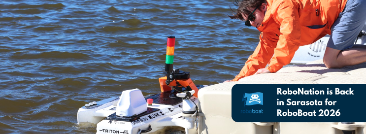
Meanwhile, the 2026 RoboBoat Competition took place at Nathan Benderson Park near Sarasota, Florida, drawing 37 high school and university teams. The event challenges students to demonstrate progress in developing autonomously operating marine systems installed on model boats. Benderson Park features a large rowing lake that has hosted Olympic rowing and canoe trials, making it a fitting venue for RoboBoat competitors and spectators.
Teams arrived with a wide variety of model boat designs and technical approaches, navigating through a series of in-water obstacle courses while gaining hands-on experience relevant to future careers. Volunteer support was plentiful, and each team brought cheering crews and technical assistance. Typical tasks included restoring simulated harbor operations, assessing underwater infrastructure and supporting exploration scenarios.
After watching more than 2 hours of posted videos, it is clear that the competition is run by a volunteer student organization. The final-round objectives were not clearly defined, and without commentary, it was difficult to determine whether any team successfully completed the obstacle course — though several boats did navigate between narrow red and green buoys after avoiding a series of posts in the water.
RoboBoat 2026
Nevertheless, it was great to see the whole gathering, many from overseas, and the level of enthusiasm. One guy told the story of how the team’s heavy equipment had survived a long-distance shipment from overseas and arrived almost intact. But during the competition, the quite heavy demo boat sank; it was just a minor setback for him — we’ll learn something and keep going! — was his mantra. As everyone in the industry knows, having your tested, verified, and 100% reliable set-up actually function at a trade show is a major hurdle we’ve all had to overcome. So, it’s good to see these young men and women learn firsthand what it takes to get a prototype to work when it becomes absolutely essential – and of course, to actually make progress and extend their reach towards autonomous robotics.
The U.S. military has been throwing Shahed-like kamikaze weaponized drones back at the country that had not only invented them, but also spread the technology to and through other antagonists, yet now feeling their impact on their own capital city — a significant success for the initial U.S. attack on Iran. And growing and supporting the latest wave of students and their autonomous aspirations at RoboBoat 2026 in Florida. One aspect of UAVs is warlike and deadly, while another is encouraging young engineering candidates towards their dreams of maritime robotic autonomy.