Category: Defense

  • Turkish kamikaze drone unveiled

    Turkish kamikaze drone unveiled

    A new Turkish-made twin-jet kamikaze drone, showcased at the Ateş Serbest-2025 exercise, features GNSS-independent autonomy, with GNSS/GPS signals, supplemented by odometric data where necessary, reports Defence Turk and Defence Index. With specially designed avionics and onboard visual-odometry algorithms, the drone can navigate and reach its assigned coordinates without dependence on satellite positioning.

    According to information obtained by both news outlets, the KZ-350 drone is being developed with a target range of 350 km. Its cruising speed is 500 km/h, cruising altitude is 3,000 meters. Its takeoff weight is 120 kg and warhead 25 kg. Two domestically produced jet engines power the drone.

    Once a mission profile is uploaded, the KZ-350 is intended to operate in a “fire-and-forget” mode. It autonomously follows its flight plan to the target area and executes its strike without external guidance.

  • Advanced Navigation launches defense INS with electronic protection

    Advanced Navigation launches defense INS with electronic protection

    Advanced Navigation, a global leader in assured positioning, navigation and timing (PNT) and autonomous systems, has introduced a line of defense-ready inertial navigation systems (INS) featuring integrated electronic protection (EP) capabilities.

    The systems are designed to counter electromagnetic warfare threats and ensure mission continuity amid a global surge in GPS jamming and spoofing attacks.

    The electronic protection range includes:

    • Boreas D Series, including the Boreas D50, D70 and D90 fiber-optic gyroscope (FOG)-based inertial navigation systems. Engineered for high-threat operational theaters, the Boreas D series supports multiple vehicle types and links to battlefield management systems and health and usage monitoring systems.
    • Certus Evo, an ultra-high accuracy MEMS GPS/inertial navigation system. The compact Certus Evo is designed for applications requiring navigation, stabilization and pointing under high-dynamics conditions.

    The rollout builds on Advanced Navigation’s announcement to establish PNT Centers of Excellence (COE) across the United Kingdom, United States and Europe to address the operational needs of NATO forces.

    Advanced Navigation’s Boreas D50 is engineered for high-threat scenarios. (Credit: Advanced Navigation)
    Advanced Navigation’s Boreas D50 is engineered for high-threat scenarios. (Credit: Advanced Navigation)

    Maximilian Doemling, chief product officer at Advanced Navigation, said countering signal jamming and spoofing requires solutions that are several steps ahead.

    “This means embedding electronic protection into the foundation of every system,” Doemling said. “Our new electronic protection range takes our proven inertial navigation technology and combines it with advanced capabilities to detect and neutralize interference in real time.”

    The systems provide real-time detection of GPS interference, cryptographic validation to identify spoofing and adaptive filtering to sustain positioning integrity. A built-in spectrum analyzer provides real-time monitoring of the radio frequency spectrum with configurable notch filters.

    The electronic protection range incorporates dual-antenna, multi-band GPS receivers supporting up to three frequency bands for improved satellite visibility in high-interference zones.

    The systems are engineered for integration into new and legacy defense platforms including combat vehicles, unmanned ground vehicles, artillery, counter-unmanned aircraft systems, radar pointing systems, intelligence, surveillance and reconnaissance payloads, unmanned aerial vehicles, unmanned surface vehicles and autonomous underwater systems.

    In September 2024, a coalition of U.S. aviation and maritime stakeholders raised concerns over the surge in GPS jamming and spoofing incidents affecting civilian airspace and international shipping lanes. The Federal Communications Commission announced plans to initiate a formal inquiry into alternative and redundant positioning, navigation and timing systems.

    Australia has established the Joint PNT Directorate, now at initial operating capability. In the U.K., the government is working to implement a framework for greater positioning, navigation and timing resilience.

    Advanced Navigation backs its solutions with a three-year warranty. All Advanced Navigation solutions are free of International Traffic in Arms Regulations restrictions.

    The Boreas D50, Boreas D70, Boreas D90 and Certus Evo are available for shipment.

  • Royal Navy trials quantum navigation systems with University of Sussex

    Royal Navy trials quantum navigation systems with University of Sussex

    The UK Royal Navy‘s Disruptive Capabilities and Technologies Office (DCTO) recently teamed up with scientists from the University of Sussex to test new navigation sensors developed to reduce reliance on GPS navigation.

    The ultra-sensitive quantum sensors measure tiny variations in the Earth’s magnetic field, offering a new way to pinpoint locations when satellite signals are jammed or unavailable.

    “We are excited and pleased to have supported this first sea trial with the University of Sussex and its quantum magnetometer technology,” said Commander Matt Steele, from DCTO. “We are also grateful to our colleagues in the Hydrographic Exploitation Group for providing one of its vessels and crew to provide a test platform.

    “To ensure it can resiliently operate in GNSS-denied and degraded environments, the Royal Navy continues to explore and accelerate the development of alternative means of navigation, such as this magnetic sensor, while positioning itself as a pioneer ‘quantum-enhanced navy’.”

    “GPS or GNSS signals are highly vulnerable to disruption: they can be jammed or spoofed, and they fail entirely underground, underwater, or in heavily obstructed environments,” said Tom Coussens, Research Fellow in Quantum Science and Technology at the University of Sussex. “This vulnerability has serious economic and operational consequences. While alternative systems such as inertial navigation and visual recognition exist, none simultaneously meet all critical requirements: long-term positional accuracy, weather independence, and resistance to jamming.”

    In the trials, a team from the university worked with the Royal Navy’s Hydrographic Exploitation Group who survey waters, recording details of depth, seabed objects and composition. The university used its Optically Pumped Magnetometers in open waters, with the trials taking place from His Majesty’s Naval Base Portsmouth.

    In addition to navigation, they also successfully mapped surrounding magnetic signatures, pointing to new methods for detecting vessels, undersea features, and potential hazards.

  • Honeywell launches alternative navigation software to counter threats

    Honeywell launches alternative navigation software to counter threats

    Honeywell has launched the Honeywell Alternative Navigation Architecture (HANA) — a software-based solution designed to ensure resilient navigation for crewed and uncrewed aircraft, as well as military surface vehicles, in environments where GNSS signals are degraded, jammed or spoofed.

    “Due to the proliferation of low-cost tools, the number of jamming, spoofing and blocking incidents is growing and is leaving more pilots and operators in the air without access to GNSS data,” said Matt Picchetti, vice president, Navigation and Sensors, Honeywell Aerospace Technologies. “HANA is our latest alternative navigation system designed to counter these threats by providing precise information on the aircraft’s position, velocity and orientation when GNSS signals are unavailable.”

    HANA is a multi-system navigation platform that includes:

    • Vision-aided navigation. Using live camera feeds to match ground imagery with map databases.
    • Magnetic anomaly-aided navigation. Detecting known variations in Earth’s magnetic field.
    • Low Earth Orbit (LEO) satellite navigation. Offering stronger, lower altitude signals more resistant to jamming..
    • Other modalities. Including light detection and ranging (lidar), radar, radios and star trackers.

    With this layered architecture, operators can mix and match modalities to meet mission-specific requirements, ensuring maximum resilience, system integrity and signal availability even in GPS-denied environments. To ensure efficiency and ease of use, HANA can run on the operator’s current computing platform or one that Honeywell provides.

    Initial release of HANA includes vision-aided navigation. Honeywell also plans to integrate magnetic anomaly and LEO satellite solutions into the platform in 2026.

    HANA’s launch marks a major milestone in Honeywell’s five-decade legacy of inertial navigation system innovation, reinforcing its leadership in aerospace navigation and its commitment to mission-critical resilience for defense and commercial aviation.

  • EASA, IATA release 4-point plan to mitigate GNSS interference risks

    EASA, IATA release 4-point plan to mitigate GNSS interference risks

    The International Air Transport Association (IATA) and the European Union Aviation Safety Agency (EASA) have published a comprehensive plan to mitigate the risks stemming from GNSS interference. The plan was among the conclusions of a jointly hosted workshop on the topic of GNSS interference.

    Given the continued rise in frequency of interference with GNSS signals, the workshop concluded that a broader and more coordinated approach is needed. focusing on four key areas: improved information gathering, stronger prevention and mitigation measures, more effective use of infrastructure and airspace management, and enhanced coordination and preparedness among relevant agencies.

    Reported incidents of interference with GNSS signals have been increasing across Eastern Europe and the Middle East in recent years. Similar incidents have been reported in other locations globally. The initial response focused only on containing those GNSS interference incidents.

    “GNSS disruptions are evolving in terms of both frequency and complexity,” said Jesper Rasmussen, EASA Flight Standards director. “We are no longer just containing GNSS interference — we must build resilience. The evolving nature of the threat demands a dynamic and ambitious action plan. Through collaboration with partners in the European Union and IATA, and by supporting the International Civil Aviation Organization (ICAO), we are committed to keeping aviation safe, secure and navigable.”

    The number of GPS signal loss events increased by 220% between 2021 and 2024, according to IATA’s data from the Global Aviation Data Management Flight Data eXchange (GADM FDX). “With continued geopolitical tensions, it is difficult to see this trend reversing in the near term,” said Nick Careen, IATA senior vice president, Operations, Safety and Security. “IATA and EASA are working together to reinforce the redundancies that are built into the system, to keep flying safe. The next step is for ICAO to move these solutions forward with global alignment on standards, guidance and reporting. This must command a high priority at the ICAO Assembly later this year. To stay ahead of the threat, aviation must act together and without delay.”

    Detailed Workshop Outcomes

    The workshop concluded that four workstreams are critical.

    1. Enhanced Reporting and Monitoring

    • Agree on standard radio calls for reporting GNSS interference and standardized notice to airmen (NOTAM) coding, i.e. Q codes.
    • Define and implement monitoring and warning procedures, including real-time airspace monitoring.
    • Ensure dissemination of information without delays to relevant parties for formal reporting.

    2. Prevention and Mitigation

    • Tighten controls (including export and licensing restrictions) on jamming devices.
    • Support the development of technical solutions to:
      • reduce false terrain warnings;
      • improve situational interference with portable spoofing detectors; and
      • ensure rapid and reliable GPS equipment recovery after signal loss or interference.

    3. Infrastructure and Airspace Management

    • Maintain a backup for GNSS with a minimum operational network of traditional navigation aids.
    • Better utilize military air traffic management (ATM) capabilities, including tactical air navigation networks and real-time airspace GNSS incident monitoring.
    • Enhance procedures for airspace contingency and reversion planning so aircraft can navigate safely even if interference occurs.

    4. Coordination and Preparedness

    • Improve civil-military coordination, including the sharing of GNSS radio frequency interference (RFI) event data.
    • Prepare for evolving-threat capabilities, also for drones.

    The workshop was held at EASA’s headquarters in Cologne, Germany, on May 22-23, and was attended by more than 120 experts from the aviation industry, research organizations, government bodies and international organizations.

  • ANELLO’s silicon photonics optical gyroscope is enabling GPS-free navigation

    ANELLO’s silicon photonics optical gyroscope is enabling GPS-free navigation

    For decades, GPS has been the cornerstone of modern navigation, guiding aircraft, vehicles, troops and commercial systems across the globe. As digital warfare intensifies, satellite signals are increasingly unreliable. From the battlefield to underground tunnels, to dense forests, and urban canyons, global positioning signals are being jammed, spoofed, or simply blocked by the environment. In these GPS-denied zones, the risks to navigation, targeting and mission success grow exponentially.

    Without reliable positioning, systems lose their sense of location, direction and speed — making it impossible to navigate to their destination. Yet in modern warfare, autonomous systems and industrial automation depend on precise and continuous navigation. ANELLO Photonics is tackling this gap head-on with a breakthrough silicon photonics-based optical gyroscope (SiPhOG) technology — one that seeks to reshape how machines, soldiers and vehicles navigate across land, air and sea when satellites fall silent.

    A Battlefield Blind Spot

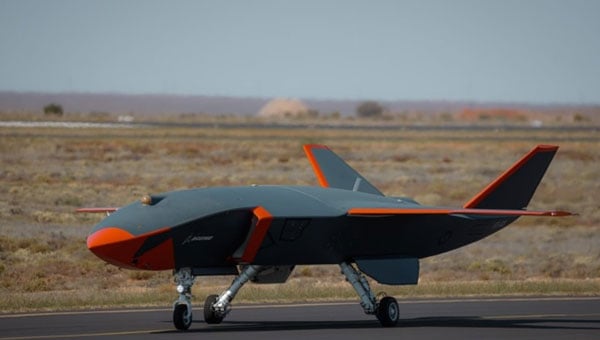
    In GPS-contested environments such as urban warzones, subterranean tunnels, dense forests or near hostile jamming equipment, traditional navigation solutions fail. Spoofing attacks can instantaneously displace autonomous vehicles by kilometers. Jamming can cripple UAVs mid-flight, causing them to crash. Even in civilian settings — especially in and around conflict zones — GPS signal loss can disrupt commercial fleets, emergency responders, and industries like mining or agriculture. These dropouts stall autonomous operations, reduce productivity, and increase the risk of severe damage.

    These issues aren’t hypothetical. Adversaries have demonstrated sophisticated GPS interference capabilities that can mislead or immobilize multi-million-dollar defense assets. The need for self-contained, spoof-resistant navigation has never been more urgent.

    Strategic-Grade Precision in a Chip

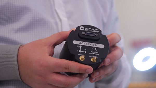
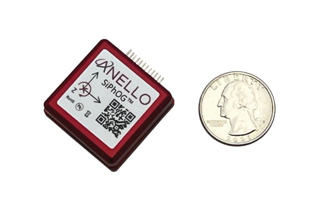
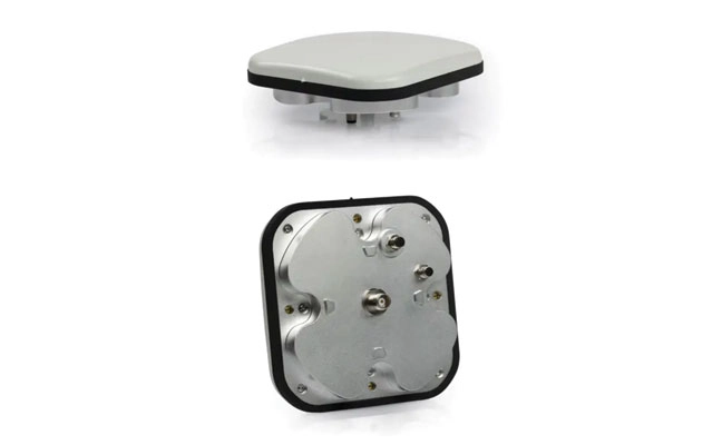
    ANELLO Photonics took a radically new approach to building gyroscopes when it built its Silicon Photonics Optical Gyroscope (SiPhOG) using the same semiconductor processes used for integrated circuits. This breakthrough makes it possible to deliver high-precision optical navigation in a chip-scale form factor — smaller than a fingernail. The SiPhOG harnesses the proven Sagnac effect — central to traditional fiber-optic gyroscopes (FOGs) — but ANELLO has reimagined it using advanced silicon photonics, integrating this into a compact silicon photonic chip.

    This innovation enables:

    • Bias drift < 0.5°/hr. A performance level previously only achieved by large, costly fiber-optic systems.
    • Nanoradian-scale angular sensitivity. Essential for accurate navigation over long durations.
    • Superior to MEMS. Resilient to vibration, thermal variation and EMI — ideal for combat zones and industrial environments.
    • Compact, coin-sized form factor. Easily integrates into existing systems and is small enough to be used for soldier-worn devices, embedded robotics and scalable mass-market applications.

    The ANELLO SiPhOG offers the precision of strategic-grade FOG systems, but with the size, weight, power and cost suitable for widespread tactical deployment to the mass market. This balance makes it uniquely positioned to serve both high-end defense missions and cost-sensitive commercial markets.

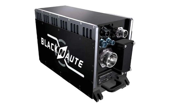
    The Full-Stack INS Advantage

    SiPhOGs alone aren’t enough. ANELLO integrates its SiPhOGs with accelerometers, magnetometers, GPS (when available) and onboard CPU logic into a full-stack inertial navigation system (INS). Additionally, these systems use the ANELLO AI-based sensor-fusion engine to intelligently reconcile data, validate signal integrity and detect anomalies, such as jammed or spoofed GPS locations or signal dropouts across land, air and sea. The ANELLO AI sensor-fusion engine processes and tracks in real time the inertial position and GPS position every ~10 ms. The system auto-corrects and seamlessly transitions the sensor modes without any human intervention — always determining what is correct and what is false or being spoofed. The ANELLO AI sensor-fusion engine is continuously being tested and optimized by the ANELLO team with various customers in the field.

    The result is a self-contained, intelligent navigation platform that maintains accurate heading, velocity and position — even in total GPS darkness. The modularity of the ANELLO systems also enables easy integration into various host platforms, from aerial drones to armored vehicles to autonomous boats and robots.

    Field-Proven Resilience in Defense

    During U.S. Department of Defense trials, ANELLO’s INS systems successfully identified and mitigated GPS spoofing attempts in real time. When a vehicle’s GPS feed suddenly shifted its perceived location by kilometers, ANELLO’s AI engine flagged the change as physically impossible, rejected the GPS input and seamlessly relied on ANELLO inertial data to maintain accurate positioning.

    Such robustness makes the ANELLO technology suitable for:

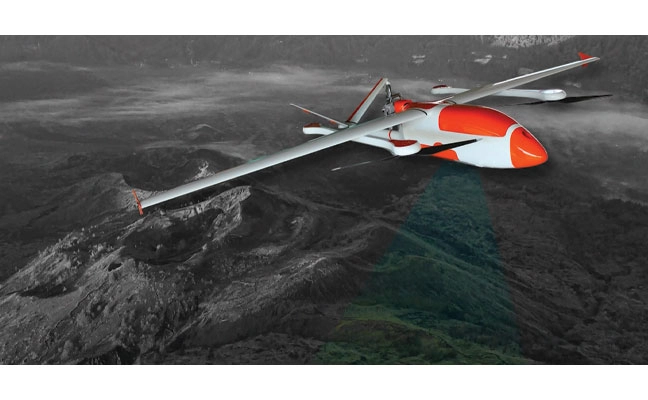
    • UAVs operating in jammed or contested airspace
    • Autonomous Ground Vehicles (AGVs) navigating GPS-denied terrain • Marine systems facing jammed or spoofed GPS signals
    • Land vehicles such as emergency responders and even delivery vehicles
    • Handheld soldier systems that demand compact, rugged navigation capabilities for on-the-move operations.

    Whether installed on armored vehicles, on drones, or embedded in next-gen infantry kits, ANELLO’s optical gyro-based solutions deliver location certainty when precision and accuracy matter.

    Cross-Sector Use Cases

    Autonomy Without Satellites: While defense remains a clear application, the broader commercial value is just as transformative. In agriculture, autonomous vehicles often lose GPS coverage under thick orchard canopies. In underground mines or port operations, satellites are blocked entirely. In these environments, ANELLO’s SiPhOG-powered INS continues to provide reliable localization and position, ensuring autonomous systems don’t stall, stray or crash.

    Commercial applications for ANELLO’s SiPhOG technology include:

    • Autonomous mining vehicles. Enables self-driving trucks and loaders to navigate through tunnels and signal-blocked environments with precision and safety.
    • Port automation and crane systems. Supports operation of automated cranes and cargo movers in GNSS-challenged port environments for uninterrupted container handling and improved throughput.
    • Industrial robotics and logistics. Powers warehouse robots and inspection systems with high-precision navigation in indoor and metallic environments where GPS is unreliable or unavailable.
    • Autonomous maritime systems. Facilitates reliable navigation for unmanned surface vessels (USVs) and autonomous underwater vehicles (AUVs) operating in coastal, harbor, or fully submerged missions where satellite signals are compromised.

    With rapid integration into commercial drones, robotic forklifts and construction fleets, ANELLO is extending military-grade navigation into everyday autonomy use cases.

    Smarter Navigation in Real Time

    At the heart of ANELLO’s platform is a sophisticated AI sensor fusion engine. Every 10 ms, the system ingests data from multiple sensors, validates physics-based plausibility and recalibrates its state estimates. This allows the system to detect and reject spoofed GPS signals, continue navigation autonomously through temporary GPS dropouts and identify signal degradation before failure occurs.

    This intelligence is what makes the system robust, not just a fallback, but a fully capable primary navigation method in harsh and dynamic environments. It also significantly reduces the operational risk and support burden typically associated with traditional inertial systems.

    Compact, Scalable, Mission-Ready

    As conflicts evolve and global infrastructure expands into GPS-hostile regions, inertial systems must become smaller, smarter and more affordable. ANELLO is advancing a roadmap toward fully integrated, chip-scale INS platforms with gyros, lasers, processors and algorithms all on a single platform. This enables faster deployment in the field, lower system power consumption and broader adoption across vast use cases for military and industrial systems.

    The company’s domestic chip fabrication capability also ensures supply chain security, an increasingly critical factor in national defense and industrial automation strategies. From soldier systems and UAVs to autonomous cargo vehicles and industrial robots, ANELLO’s technology is positioning itself as a cornerstone for resilient, GPS-independent autonomy.

    Navigatng a Standard for a Contested World

    The future of autonomous operations—military and civilian alike—will need to depend on navigation systems that do not falter when GPS disappears. With its SiPhOG-based inertial platform, ANELLO Photonics is offering not just a backup system, but a new standard: one that combines strategic-grade precision, compact design and AI-driven reliability that can be delivered to the mass market and installed into any vehicle or any moving platform.

    In an era where signal denial is not just a threat but a tactic, assured positioning is no longer optional—it’s essential. ANELLO is redefining the future of navigation, empowering not just autonomous systems but also the people who rely on navigation to operate with confidence and precision — anywhere, anytime — even when the sky goes dark.

  • Orkid’s new VTOL drone integrates GNSS, lidar, photogrammetry and Starlink

    Orkid’s new VTOL drone integrates GNSS, lidar, photogrammetry and Starlink

    Drone-maker Orkid has unveiled a new variant of its Orkid 260 drone that incorporates four technologies to improve aerial data-capture technology.

    According to the company, the Orkid 260VTOL represents a leap forward in the integration of advanced sensing and communication technologies, setting a new benchmark for multi-mission drone capability across commercial and industrial applications. The company said it is the “first vertical take-off and landing (VTOL) drone to bring all four of the most advanced aerial data capture technologies together — onboard, fully integrated, and operating simultaneously.”

    The system combines lidar (YellowScan Surveyor Ultra), photogrammetry (Phase One P5 camera), GNSS/IMU (Trimble Applanix APX-RTX), and Starlink satellite communications integration in a single platform.

    Built on a 100% electric, NDAA-compliant architecture, the aircraft delivers an estimated 1.5 hours of flight endurance with a range of up to 75 miles. Designed for mapping, surveying, utilities, oil and gas, defense, and critical infrastructure inspection, the new model expands the operational scope for high-precision, long-range missions.

  • Maritime agency warns of AIS jamming in Red Sea region, ICAO condemns Russia and North Korea

    Maritime agency warns of AIS jamming in Red Sea region, ICAO condemns Russia and North Korea

    The UK Maritime Trade Operations (UKMTO) has issued an advisory following a surge in reports of interference affecting GNSS and Automatic Identification System (AIS) displays. The disruptions, which began Oct. 3, are concentrated around Bandar-e-Pars (Iran), the Strait of Hormuz and Port Sudan.

    “UKMTO has received numerous reports of GNSS interference from vessels in the Red Sea and Persian Gulf, between October 3 and 7,” the operations centre said in the alert. “This is a significant increase of reports compared with the same period in the previous week.”

    UKMTO urged vessels to exercise heightened caution. Ships in the Gulf, Port Sudan, and Suez Canal areas are experiencing consistent AIS speed anomalies, further complicating navigation.

    Russia and North Korea named as culprits

    Also this week, the International Civil Aviation Organization (ICAO) Assembly issued two resolutions condeming Russia and North Korea for recurring incidents of GNSS interference, citing the intentional interference as infractions of the 1944 Convention on International Civil Aviation. The agency urgently called upon both countries to comply strictly with their obligations under the convention.

    The assembly also deplored the fact that incidents of GNSS interference originating from the two countries have continued despite concerns repeatedly expressed by the ICAO Council about the harmful impact of GNSS interference on the safety and security of international civil aviation. 

    Photo: ICAO
    Photo: ICAO

    The assembly reiterated the paramount importance of preserving the safety and security of international civil aviation through strict compliance with the principles enshrined in the Chicago Convention and its Annexes. It also recalled Assembly Resolution A41-8, which recognized that the spectrum used by GNSS should be free from harmful interference and urged countries to refrain from any form of jamming or spoofing affecting civil aviation.

    The resolutions were issued as the ICAO triennial assembly in Montreal concluded on Oct. 5.

  • Q-CTRL’s quantum navigation named to TIME’s best invention list

    Q-CTRL’s quantum navigation named to TIME’s best invention list

    A software-ruggedized quantum navigation system was chosen as one of The Best Inventions of 2025 by TIME magazine.

    Ironstone Opal by Q-CTRL has been field-validated in air, land and maritime trials. It provides a solution to GPS denial, which has become an increasing danger in conflict zones and recently threatened a plane carrying European Commission president Ursula von der Leyen. Q-CTRL is based in Sydney, Australia.

    Ironstone Opal leverages quantum sensors – stabilized using software – to provide navigation immune to the kinds of interference plaguing commercial aviation, shipping and defense operations.

    In airborne trials, Ironstone Opal enabled GPS-free navigation with an accuracy up to 111 times better than the best conventional GPS alternative, even under highly dynamic maneuvers. It delivered GPS-like positioning accuracy down to just 4 meters over flights up to 700 kilometers long.

    Most recently, Ironstone Opal operated continuously for more than 144 hours on an Australian Navy vessel, the MV Sycamore, trialling gravimetric navigation capabilities. 

    “In today’s sophisticated threat environment — marked by jamming, GPS denial, and spoofing — quantum sensing offers a strategic advantage delivering resilient and precise capabilities where traditional systems fall short,” said Jonathan Green, Chief Technology Officer, Northrop Grumman Mission Systems. “As a leader in quantum technology, Northrop Grumman supports innovators like Q-CTRL in advancing the quantum industry to enhance national security through cutting edge innovation.”

    Each year, TIME recognizes 300 products, software and services that are changing the world, including scientific or technological breakthroughs and innovations that make life easier and more sustainable. Ironstone Opal was identified through research from TIME’s global network of reporters and expert contributors based on key evaluation factors like originality, efficacy, ambition and impact.

    The Key to Ironstone Opal

    Ironstone Opal’s quantum sensors detect tiny, otherwise imperceptible signals from Earth’s structure that serve as gravimetric or magnetic “landmarks” for navigation, which are then compared with geophysical maps for precise positioning. Q-CTRL’s proprietary software-ruggedization hardens these quantum sensors for operation in the real world, allowing resilient performance in demanding environments.

    The system can function as a robust backup for GPS on both crewed and uncrewed defense platforms, as well as in commercial settings. More than 1,000 commercial flights per day are affected by GPS denial, and many key players in the aerospace industry, including Airbus, are looking into quantum-assured navigation technologies as a solution.

    TIME’s recognition of Ironstone Opal follows August’s news that DARPA awarded Q-CTRL two contracts totalling $24.4 million USD to develop quantum sensors for navigation on defense platforms. Also, in March, the Department of Defense’s Innovation Unit (DIU) awarded a contract to Lockheed Martin and Q-CTRL to develop a quantum-enabled inertial navigation system.

  • Unmanned systems updates: Government shutdown risks, UAS advances and eVTOL industry challenges

    Unmanned systems updates: Government shutdown risks, UAS advances and eVTOL industry challenges

    To echo the Association for Uncrewed Vehicle Systems International’s (AUVSI) pleas to Congress, a prolonged government shutdown could impact recent efforts to establish stronger counter-UAS protection for sensitive establishments across the U.S. and forestall key Federal Aviation Administration (FAA) hiring plans to support safe drone integration into the U.S. National Airspace System.

    Nothing is good about having roughly 750,000 people out of work and stalling their buying contributions to the American economy, not to mention that air traffic controllers, Border Patrol agents and other essential services are still working without pay. Hopefully common sense will prevail and the government will reopen soon.


    Originally known as the Boeing Airpower Teaming System or “Loyal Wingman,” the Boeing Australia MQ-28A Collaborative Combat Aircraft has been rechristened. Developed jointly by Boeing and the Royal Australian Air Force, the MQ-28A was not entered in the U.S. CCA competition and has remained fully employed in Australia with its team. Now referred to as the “Ghost Bat” — a name inspired by a north Australian flying bat by the same name, which uses “multi-spectral sensors” to hunt and learn in packs together — the name is a fitting analogy for the anticipated role of the MQ-28A.

    Ghost Bat taxies at RAAF base Woomera in Australia. (Credit: Beoing)
    Ghost Bat taxies at RAAF base Woomera in Australia. (Credit: Beoing)

    Flying since February 2021, the Ghost Bat has made significant steps toward operational readiness. Using AI-powered intelligence to perform autonomously, Ghost Bat has a replaceable nose section, each fitted with different sensor suites appropriate for different missions.

    With eight vehicles now available for a comprehensive operational verification test, in June and four months ahead of schedule, Ghost Bat completed a series of flights at both Woomera and Tindal bases in northern Australia. Capabilities demonstrated included autonomous missions, multi-ship operations and teaming with an E-7A Wedgetail early warning aircraft — including data fusion between multiple MQ-28A Ghost Bat aircraft and the crewed Wedgetail. The aircraft has flown for 150 hours and has accomplished more than 20,000 hours of virtual and ground testing. Able to find, fix, track and target, MQ-28A has proven its capability to carry out essential pieces of the air combat role — remaining elements include engage and assess, which will involve carrying air-to-air missiles later in 2025.

    This apparently brings the Boeing MQ-28A close to operational capability and ready for volume manufacturing. The eight aircraft have been built at an automated manufacturing facility in Melbourne, where two improved versions are currently being built that incorporate improvements developed through the testing phase, and a combined GPS/INS system will replace the commercial GPS on the aircraft. Ground has meanwhile been broken on a 100,000-square-foot high-volume manufacturing plant in the Wellcamp Aerospace and Defence Precinct in Queensland — expected to be complete within three years.


    While electric vertical take-off and landing (eVTOL) air-taxis under development progress towards certification by FAA and other agencies, introductory trials are also underway and agreements for future collaboration are being made all over around the world. While major players such as airlines and manufacturers have invested heavily to provide the capital for eVTOL development and manufacturing, one such agreement appears to be in trouble.

    Lilium jet eVTOL (Credit: Lilium)
    Lilium jet eVTOL (Credit: Lilium)

    Lilium, a jet eVTOL developer, and GlobeAir, an existing operator of an Austrian fixed-wing business aviation operation, signed a memorandum of understanding in September 2022. GlobeAir posted an article on its website that said it saw the agreement with Lilium as a step toward the “next generation of regional air mobility” and that it intended to buy 12 jet-powered Lilium eVTOL aircraft “to operate in Northern Italy and the French Riviera.” GlobeAir was also reported to have supported the inclusion of several potential key local suppliers to participate in the build of Lilium aircraft.

    Lilium went bankrupt in October 2024, and its assets and intellectual property have been up for bids. Emerging briefly from bankruptcy protection, Lilium again ended up broke and on the auction block in February 2025. Vaeridion has already purchased Lilium’s battery facility, and Ambitious Air Mobility is close to a deal to acquire the rest.

    The CEO of GlobeAir has now told the magazine Aviation Week in an interview that he expects the whole eVTOL adventure to fail, given the cost of not only vehicle development and construction but also the landing and charging infrastructure needed. Other hurdles include the level of test and verification and excessive levels of documentation — overall being “highly regulated, with low margins.” It’s an unfortunate, perhaps premature assessment from an existing fixed-wing operator who contracts out last-mile passenger transitions to third-party helicopter operators.


    So, there is another mixed bag of going ons in the world of unmanned and derivative eVTOL aircraft – hopefully following the restoration of funding for the government, paused programs will be restored to extend counter UAS defenses across the U.S., Ghost Bat will complete its combat engage and assess phases and there will be much better news on the eVTOL front.

  • Four innovations strengthening navigation resilience against RF interference

    Four innovations strengthening navigation resilience against RF interference

    1. Anti-jamming antenna
    For defense, marine and critical infrastructure

    The CR8894SXF+ is an advanced controlled reception pattern antenna (CRPA) for anti-jamming. It is engineered to provide efficient interference protection and real-time situational awareness across critical infrastructure, marine and defense environments where GNSS continuity is mission critical. It is specifically designed to provide a low-power and lightweight solution in a compact size. It features advanced in-band null forming to protect GPS L1/L2 and Galileo E1/E5b signals, helping ensure resilient positioning, navigation and timing in environments with contested, congested or degraded radio frequency conditions. The antenna incorporates Calian’s eXtended Filtering interference mitigation technology to maintain performance and reliability when RF threats are present. The CRPA supports in-band null-forming of 20 dB to 40 dB and out-of-band rejection up to 80 dB across 700 MHz to 2,500 MHz. It includes two independent low-noise amplifier channels, allowing continued operation if one signal band is compromised. The antenna forms nulls in both upper (L1/E1) and lower (L2/E5b) GNSS bands to actively suppress jamming sources. A serial output interface provides real-time feedback, enabling users to monitor RF conditions and system status. Calian GNSS, calian.com

    2. PNT system
    Integrates GNSS receiver, INS, atomic clock

    Photo: SAFRAN
    Photo: Safran

    The BlackNaute autonomous positioning, navigation and timing (PNT) system integrates Safran’s HRG dual-core inertial navigation technology, the Skylight multi-mode GNSS receiver board, and an atomic clock to offer navigation resilience in challenging electronic warfare environments. BlackNaute’s built-in atomic clock is designed to maintain precise timing, which is essential for secure communications and collaborative combat operations. The system features advanced anti-jamming and anti-spoofing algorithms, which have been validated in more than 16,000 operational cases. These capabilities allow BlackNaute to detect compromised signals and automatically switch to autonomous and trusted navigation and timing sources to ensure continuity of operations. Its modular design allows it to be adapted across a variety of platforms. Airbus Helicopters has selected the NH90 to be equipped with this new Embedded GNSS and Time INS (EGTI). Safran Electronics & Defense, safran.com

    3. Interference detection
    Suite enhanced for greater accuracy, coverage and insight

    Photo: US NAVY
    Photo: US Navy

    HawkEye 360’s GNSS-I Detection suite includes powerful enhancements to its GNSS interference detection capabilities. The upgrades — designed with defense, intelligence and national security operations in mind — offer unprecedented accuracy, coverage and insight into global GPS jamming and spoofing threats. The update includes a new wider frequency algorithm that better distinguishes individual emitters, incorporates GPS spoofing detection, and is terrain adjusted for better geolocation accuracy, delivering greater situational awareness and more precise geolocation of interference sources worldwide. The enhanced product suite supports strategic decision-making by providing timely, precise insight into potential signal disruptions, enabling stakeholders to better assess risk, respond confidently, and maintain operational continuity in dynamic environments. HawkEye 360, he360.com

    4. VTOL UAS
    For complex intelligence, surveillance and reconnaissance missions

    Photo: ESEN
    Photo: ESEN

    The GöKHUN unmanned aerial system (UAS) is a tactical vertical take-off and landing (VTOL) drone system developed for versatile missions on land or at sea. GöKHUN combines the compact mobility of a NATO Class I UAV with the performance data of a Class II tactical system. It uses the SP 210 FI GS 2-stroke engine from Sky Power International. With a take-off weight of up to 110 kg and a maximum fuel and payload capacity of 26 kg, the GöKHUN can remain in the air for up to 16 hours with a minimum payload. Even with a demanding sensor load of 12 kg, it can achieve a flight duration of around nine hours, making it suitable for long-endurance reconnaissance and surveillance missions. The GöKHUN’s cruising speed is between 96 and 158 km/h. The maximum range with direct line-of-sight is over 150 km, with the system reaching a service ceiling of approximately 5,500 m. ESEN, esensi.com.tr

  • Mayflower receives US patents for signals of opportunity anti-jamming tech

    Mayflower receives US patents for signals of opportunity anti-jamming tech

    Mayflower Communications Company, a Massachusetts-based leader in advanced anti-jam system solutions for military and commercial markets, has been granted two U.S. patents — US 11,262,457 and US 12,235,365 — that significantly advance its GNSS anti-jam capabilities.

    The patents expand Mayflower’s proprietary technology into signals of opportunity (SoOP), enabling interference suppression across both Iridium and GNSS frequency bands.

    GPS remains a cornerstone of positioning, navigation and timing (PNT) for both military and commercial platforms. However, its vulnerability to intentional and unintentional jamming and spoofing has underscored the need for more resilient PNT solutions. Signals of opportunity — non-navigational RF signals not originally intended for PNT — can serve as valuable backups when GPS signals are degraded or denied. But like GPS, these signals are also susceptible to interference and require protection to be viable contributors to a resilient PNT framework.

    Mayflower’s newly patented technology provides simultaneous protection of GPS and Iridium satellite signals within a compact, low size, weight and power (SWaP) footprint — critical for modern platforms operating in GPS-contested environments.

    “The issuance of these seminal patents by the U.S. Patent and Trademark Office affirms Mayflower’s continued leadership in resilient PNT technologies for both military and commercial markets,” said Triveni Upadhyay, president of Mayflower. “Our innovative approach to filtering interference across multiple satellite communication systems — including Iridium — demonstrates our ability to meet the growing demand for GPS-alternative solutions. Leveraging signals of opportunity without significantly increasing SWaP is a key milestone in delivering more robust, operationally viable PNT systems. We’re excited to bring this technology to our partners across sectors.”