Septentrio, part of Hexagon, has announced the launch of the mosaic-G5 P8 receiver. The multi-frequency module, measuring 23 mm by 16 mm and weighing 2.2 grams, enables accurate and resilient positioning without any performance compromises for mission-critical devices, UAVs, marine vessels, and rail applications.
Built for reliable operation in contested GNSS environments, AIM+ Ultimate technology protects the receiver from powerful and sophisticated GNSS jamming and spoofing attacks. It delivers comprehensive situational awareness, combining timely interference and spoofing indicators with detailed power and frequency data, which can help localize jammers.
“The mosaic-G5 P8 is in a class of its own: uncompromised GNSS resilience in a secure, ultra‑compact, all‑in‑one design,” said Yasmine Hunter, product manager at Septentrio.
The newly released module features an integrity-focused design that ensures truthful positioning and reporting, enabling the system to quickly switch to other sensors during GNSS disruptions in heavily compromised environments. Secure communication with input and output authentication prevents unauthorized access and data interception. mosaic-G5 P8 also offers high update rate with low latency, supporting reliable navigation and control in highly dynamic applications.
The module is compatible with widely used, open-source autopilots like PX4 and ArduPilot, simplifying drone integration. The mosaic-G5 P8 evaluation kit, featuring direct autopilot connections, is available for testing and prototyping, and the RxTools user interface streamlines setup and evaluation.
Meet Septentrio’s GNSS experts and mosaic-G5 P8 during SOF Week in Tampa, Florida, May 18–21, in booth #609.
Research drawing on data from Spire Global’s GNSS-R constellation has enabled the generation of Arctic-wide sea ice maps, marking a major step forward for GNSS-R. The research, enabled by the European Space Agency — suggests harnessing GNSS-R signals could become an important complement to established ice-monitoring altimetry missions. The study leveraged Spire’s GNSS-R data to retrieve sea ice freeboard measurements across an entire winter season. The results show strong alignment with established altimetry datasets, including the ESA’s CryoSat mission.
Russian jamming goes to the dogs
Credit: Marit Leinan Abrahamsen/Finnmarksløpet
Military jamming and spoofing from Russia’s Kola Peninsula interfered with GNSS trackers on dog sleds in Europe’s longest sled race, the 1,200- km Finnmarksløpet, held in Norway in March. The electronic warfare degraded GPS signals, forcing the mushers to rely more on trail markings and use traditional compasses and maps. Event organizers, who provided a live tracking system for fans, found it difficult to follow along, but the racers finished without incident.
Michigan Technological University is examining 11,000 historical images of the state’s Upper Peninsula to find precisely where each photographer stood to take the photo. According to university GIS data librarian Bob Cowling, the location will provide richer information about a place’s surroundings, especially if structures or environmental landmarks are no longer present. Donated historical images often arrive without any dates or location information attached to them. The project will make them easier to find on a map and make it possible to visualize what was there in the past.
In February 2023, a devastating 7.8-magnitude earthquake struck near the Türkiye-Syria border, followed by a second nearly as strong. Six Turkish universities have launched TR-TRAK-GNSS, a real-time geodetic monitoring network to trace earthquake-related ground deformation across Thrace and the Southern Marmara region. The 28-station system is expected to evolve into a major scientific and early warning system for earthquakes. Once fully deployed, it will form a continuous monitoring ring encircling Thrace and Southern Marmara.
ZED-X20P-01B adds Galileo High Accuracy Service (HAS), Moving Base, and stronger resilience against jamming and spoofing, enabling scalable high-precision positioning for global OEM deployments.
U-blox has launched and availability of its new all-band GNSS module variant, the ZED-X20P-01B.
Building on the proven capabilities of the ZED-X20P platform, the new module expands access to high-precision positioning by bringing global precise point positioning (PPP) to a broader range of use cases. With support for Galileo High Accuracy Service (HAS) the ZED-X20P-01B enables OEMs to launch products with reliable, decimeter-level positioning across markets worldwide, without tying product availability to local correction infrastructure.
The ZED-X20P-01B extends u-blox expertise in GNSS by addressing a growing market need: making high-precision positioning more practical to deploy at global scale. By integrating enhanced PPP capabilities, including Galileo HAS functionality, and improving resilience against jamming and spoofing (verified at Jammertest 2025), the module gives developers a dependable positioning that can serve both as a primary global solution and as a fallback where local RTK correction services are limited, unavailable, or impractical. This flexible approach opens new opportunities for global OEMs to design and ship products with reliable decimeter-level accuracy out of the box across regions, applications, and operating conditions.
The ZED-X20P-01B. (Credit: U-blox)
Built for global OEM deployment
The ZED-X20P-01B is especially valuable for products shipped across regions with inconsistent access to RTK networks, SBAS coverage, or reliable communications. This gives manufacturers a more flexible path to delivering high-precision positioning worldwide, while also opening new opportunities in remote, rural, and infrastructure-limited environments.
Representative applications include:
UAVs without reliance on continuous connectivity for mapping and navigation:
Marine applications such as dredging, near-shore navigation, and seabed mapping without complex RTK setup
Precision agriculture, construction and mining in remote locations, including geofencing and equipment tracking
Environmental and utility mapping in infrastructure-limited regions
Robotics and autonomous platforms requiring reliable relative positioning through Moving Base functionality.
Enhanced performance and robustness
The ZED-X20P-01B builds on the core strengths of the ZED-X20P while introducing key enhancements:
Native support for Galileo HAS for globally accessible PPP corrections
Moving Base functionality for applications requiring precise relative positioning
Improved jamming and spoofing detection and mitigation for mission-critical applications
Continued compatibility with u-blox PointPerfect services for scalable correction options.
Together, these enhancements help OEMs deliver reliable high-precision positioning across wider geographies and more demanding RF environments, while keeping system design streamlined. Most importantly, they make decimeter-level accuracy out of the box a practical option for products deployed globally.
Ease of integration and scalability
Maintaining the established ZED form factor, the ZED-X20P-01B offers a seamless upgrade path for existing customers. With its compact design it reduces the need for additional hardware or complex host-side computation.
This helps developers accelerate time to market and scale from pilot projects to global commercial rollouts without redesigning their systems for each target region. For OEMs building products for international shipment, the ZED-X20P-01B offers a practical way to standardize around one high-precision platform while expanding coverage, improving resilience, and simplifying deployment.
“ZED-X20P-01B reflects our commitment to making high-precision positioning more scalable, resilient, and easier to deploy globally,” said Andreas Thiel, CEO of u-blox, said. “With Galileo HAS support, Moving Base, stronger protection against jamming and spoofing, and a seamless path for existing ZED-X20P customers, we are enabling OEMs to bring reliable decimeter-level positioning to more products, in more markets, with fewer deployment constraints.”
Experience ZED-X20P-01B live
U-blox will showcase the ZED-X20P-01B at XPONENTIAL 2026 in Detroit, where visitors can experience the module live at booth 23023.
Availability
Samples and evaluation kits for the ZED-X20P-01B will be available in June.
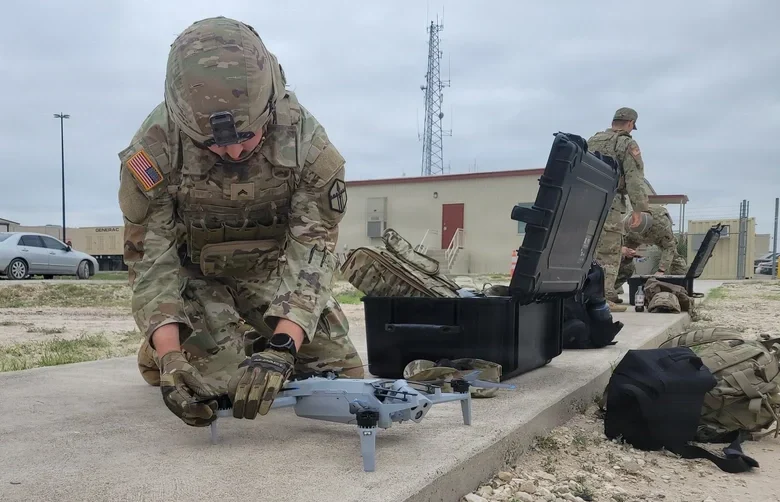
Patented software visual-inertial cooperative navigation technology has potential to target defense, counter-drone (C-UAS), electronic warfare, and autonomous unmanned aircraft systems markets
NorthStrive Defense Tech LLC has secured a license option in connection with a proprietary U.S. patented autonomous navigation technology through an exclusive option agreement with a corporation.
The technology is designed to enable autonomous positioning and navigation for unmanned aircraft systems and drones operating in GPS-jammed, GPS-spoofed and GPS-denied environments, addressing a core capability gap identified by the U.S. Department of Defense (DoD) and allied defense programs worldwide.
NorthStrive Defense Tech LLC is a wholly-owned subsidiary of PMGC Holdings Inc.
The option agreement provides NorthStrive Defense Tech with an exclusive option, within the aerospace and defense technologies field, to obtain an exclusive license as to certain patent rights for U.S. Patent No. 12,277,716 B2, covering a cooperative navigation system for unmanned aircraft systems, also known as drones, operating in GPS-denied and GPS-degraded environments.
The option is also for a non-exclusive license in the field as to certain know-how connected to these patent rights, as further set in the option agreement. On NorthStrive Defense Tech’s exercise of this option, the parties will enter into negotiations for a definitive license agreement.
The technology has the potential to enable drones to navigate accurately without GPS by using onboard cameras and inertial sensors to estimate position relative to the local environment. The approach applies visual-inertial odometry (VIO) and sensor-fusion techniques, including an Extended Kalman Filter (EKF) for real-time state estimation and cooperative multi-vehicle data sharing, which together represent foundational building blocks of next-generation autonomous systems.
When multiple drones operate, they share positional data in real time to collectively improve each vehicle’s accuracy, with performance formally evaluated under real-world GPS-denied conditions.
GPS-denied navigation has emerged as one of the most urgent challenges in modern drone operations. Conflicts in recent years have demonstrated that GPS signals cannot be relied upon in contested environments, where jamming and spoofing are routinely deployed to disable unmanned systems.
Vulnerabilities in GNSS signals have made anti-jamming and anti-spoofing capabilities a top priority within U.S. defense modernization programs, the Pentagon, the DoD and allied NATO forces. That operational reality has driven substantial investment across the defense sector, with the GPS-denied drone navigation market projected to grow at a CAGR of 31.7% through 2030, according to Technavio.
Key potential capabilities include:
Vision and inertial-based navigation requiring no GPS signal (visual-inertial odometry / VIO with Extended Kalman Filter (EKF)-based state estimation)
Cooperative swarm localization through inter-vehicle range sharing, a foundational capability for drone swarm and counter-drone (C-UAS) operations
Scalable architecture supporting operations from individual drones to full swarms, with an architecture positioned for integration with AI-enabled autonomous systems
Technology formally evaluated for accuracy and performance under real-world GPS-denied conditions.
The system’s modular design keeps flight-critical estimation onboard each drone while requiring minimal data exchange between vehicles, making it practical for contested environments where communications bandwidth is limited or actively degraded.
The International Air Transport Association (IATA) has called for vigilance following the increasing number of GNSS spoofing and jamming incidents worldwide. The growing interference poses a significant risk to flight navigation and pilot safety.
Of note is a spike in incidents at major Indian airports. Almost 2,000 GNSS interference incidents have been logged at airports in India since 2023, including the airports in Delhi, Mumbai, Kolkata, Amritsar, Hyderabad, Bengaluru and Chennai.
IATA represents more than 360 airlines, accounting for 80% of global air traffic. Indian carriers Air India, IndiGo, Air India Express and SpiceJet are members.
“GPS spoofing and jamming incidents are increasing rapidly across the world,” said IATA Director General Willie Walsh, speaking at an industry event in Geneva. “This is not merely a technical concern — it’s an operational vigilance issue for pilots.”
Walsh noted a higher frequency of interference events, expanding well beyond conflict zones and affecting global civil aviation routes.
India’s Civil Aviation Ministry informed Parliament that between November 2023 and November 2025, a total of 1,951 GNSS interference cases were reported. The data collection began after the Directorate General of Civil Aviation (DGCA) issued an advisory circular in November 2023, mandating airlines to report all GNSS-related disruptions.
India’s Directorate General of Civil Aviation (DGCA) has issued an adendum on reporting procedures for suspected GNSS spoofing, reports news service AIN. On Nov. 10, the DGCA began requiring that all spoofing and jamming incidents be reported within 10 minutes, following an intense period of disruptions around Indira Gandhi International Airport in Delhi.
The addendum is meant to clarify exactly what pilots and operators are required to do both before and after a GNSS interference incident is suspected.
The disruptions produced false EGPWS alerts, position errors, and incorrect altitude indications, according to OpsGroup. The interference briefly drove ADS-B integrity in the Delhi terminal area to zero, affecting hundreds of aircraft and leaving controllers unable to rely on GPS-based surveillance.
In recent years, hostile actors have jammed or spoofed PNT services, demonstrating potential threats to key services. PNT can also be affected by natural events like solar flares from the sun.
The £155 million funding was announced Wednesday by Science Minister Lord Vallance at the Royal Institute of Navigation’s annual PNT Leadership Seminar, which brings together researchers, innovators and business leaders from across the sector.
The investment includes initial work to provide PNT that is independent of signals from satellites, making it harder to jam or spoof; PNT resilience at the National Physical Laboratory; and a new system to proactively monitor for threats to the UK’s PNT services.
The £155 million funding consists of:
£71 million to begin work on a UK National Enhanced Long-Range Navigation (eLoran) program, providing PNT across land, air and sea independent of signals from satellites, and hard to jam or spoof.
£68 million for further development of the National Timing Centre (NTC) program. The NTC is being delivered by the National Physical Laboratory to develop the UK’s first nationally distributed time infrastructure. As well as boosting resilience, it could help with innovative new uses of technologies like 5G, satellite communications, and self-driving vehicles.
£13 million for work on a UK GNSS interference monitoring program, to deliver a world-leading capability for the UK to monitor and react to threats to PNT signals, like jamming and spoofing.
£3 million for the Space-Based Time Transfer R&D program. This will develop the technology required to deliver global timing systems independent of GPS and other GNSS.
“Having resilient and enduring access to Position, Navigation and Timing Services is a critical part of life in today’s world, and a major plank in the UK’s national security,” Vallance said. “So many of the things we take for granted every day, from using our phones to planning a journey, simply couldn’t happen without it. The UK is a leader in this field, but in an uncertain world we cannot be complacent. The funding we are announcing today will ultimately help protect Britain from the risks posed to PNT, from both accidental outages and hostile acts, safeguarding everyone’s wealth and wellbeing.”
“Strengthening the UK’s PNT capabilities will give direction to our growing PNT industry, supporting the wider economy and national renewal, whilst cementing the UK’s position as a global PNT leader,” Vallance said.
Today’s news comes after a substantial year of progress for UK PNT. The government agreed to closer work with both the US and France around PNT resilience, as part of September’s UK-US Technology Prosperity Deal and July’s UK-France Summit.
DSIT published a Call for Evidence on PNT growth in June, seeking views on the PNT market and R&D landscape in the UK, as well as the barriers to market entry, commercialisation, and user adoption. We will publish a summary of our findings later this year.
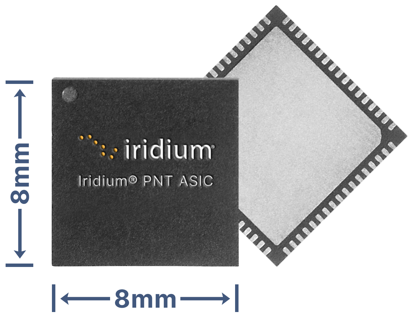
Iridium Communications Inc. has unveiled a dedicated, miniature application-specific integrated circuit (ASIC), the Iridium PNT ASIC. Engineered for seamless integration into a wide range of electronic devices, the Iridium PNT ASIC will deliver authenticated, pole-to-pole positioning, navigation and timing (PNT) data. It will provide a resilient alternative to traditional GNSS, offering protection against spoofing and jamming for consumer, industrial and government applications.
The Iridium PNT ASIC measures 8 x 8 mm and can be fit into devices ranging in size from consumer products to major infrastructure systems like power grids, transportation systems and telecom networks. When embedded in a device, the Iridium PNT ASIC receives a cryptographically secure time and location data signal from the Iridium satellite network that is 1,000 times more powerful than GPS and capable of working inside buildings. This can help GNSS-dependent applications to not only detect a problem but also maintain operations until it is resolved. The Iridium PNT ASIC will also continuously verify signal integrity, making it a suiitable alternative or primary source of PNT data.
Iridium showcased the ASIC’s capabilities during September’s Jammertest, an annual event that evaluates the resilience of GNSS and alternative PNT technologies under jamming and spoofing attacks. The Iridium PNT ASIC maintained both timing accuracy and reliable navigation during controlled exercises.
Iridium is inviting organizations to apply to participate in beta trials, and, if selected, they will receive Iridium PNT ASIC evaluation kits, enabling early integration and testing. The Iridium PNT ASIC is planned for commercial availability in mid-2026.
The International Air Transport Association (IATA) and the European Union Aviation Safety Agency (EASA) have published a comprehensive plan to mitigate the risks stemming from GNSS interference. The plan was among the conclusions of a jointly hosted workshop on the topic of GNSS interference.
Given the continued rise in frequency of interference with GNSS signals, the workshop concluded that a broader and more coordinated approach is needed. focusing on four key areas: improved information gathering, stronger prevention and mitigation measures, more effective use of infrastructure and airspace management, and enhanced coordination and preparedness among relevant agencies.
Reported incidents of interference with GNSS signals have been increasing across Eastern Europe and the Middle East in recent years. Similar incidents have been reported in other locations globally. The initial response focused only on containing those GNSS interference incidents.
“GNSS disruptions are evolving in terms of both frequency and complexity,” said Jesper Rasmussen, EASA Flight Standards director. “We are no longer just containing GNSS interference — we must build resilience. The evolving nature of the threat demands a dynamic and ambitious action plan. Through collaboration with partners in the European Union and IATA, and by supporting the International Civil Aviation Organization (ICAO), we are committed to keeping aviation safe, secure and navigable.”
The number of GPS signal loss events increased by 220% between 2021 and 2024, according to IATA’s data from the Global Aviation Data Management Flight Data eXchange (GADM FDX). “With continued geopolitical tensions, it is difficult to see this trend reversing in the near term,” said Nick Careen, IATA senior vice president, Operations, Safety and Security. “IATA and EASA are working together to reinforce the redundancies that are built into the system, to keep flying safe. The next step is for ICAO to move these solutions forward with global alignment on standards, guidance and reporting. This must command a high priority at the ICAO Assembly later this year. To stay ahead of the threat, aviation must act together and without delay.”
Detailed Workshop Outcomes
The workshop concluded that four workstreams are critical.
1. Enhanced Reporting and Monitoring
Agree on standard radio calls for reporting GNSS interference and standardized notice to airmen (NOTAM) coding, i.e. Q codes.
Define and implement monitoring and warning procedures, including real-time airspace monitoring.
Ensure dissemination of information without delays to relevant parties for formal reporting.
2. Prevention and Mitigation
Tighten controls (including export and licensing restrictions) on jamming devices.
Support the development of technical solutions to:
reduce false terrain warnings;
improve situational interference with portable spoofing detectors; and
ensure rapid and reliable GPS equipment recovery after signal loss or interference.
3. Infrastructure and Airspace Management
Maintain a backup for GNSS with aminimum operational network of traditional navigation aids.
Better utilizemilitary air traffic management (ATM) capabilities,including tactical air navigation networks and real-time airspace GNSS incident monitoring.
Enhance procedures for airspace contingency and reversion planning so aircraft can navigate safely even if interference occurs.
4. Coordination and Preparedness
Improve civil-military coordination, including the sharing of GNSS radio frequency interference (RFI) event data.
Prepare for evolving-threat capabilities, also for drones.
The workshop was held at EASA’s headquarters in Cologne, Germany, on May 22-23, and was attended by more than 120 experts from the aviation industry, research organizations, government bodies and international organizations.
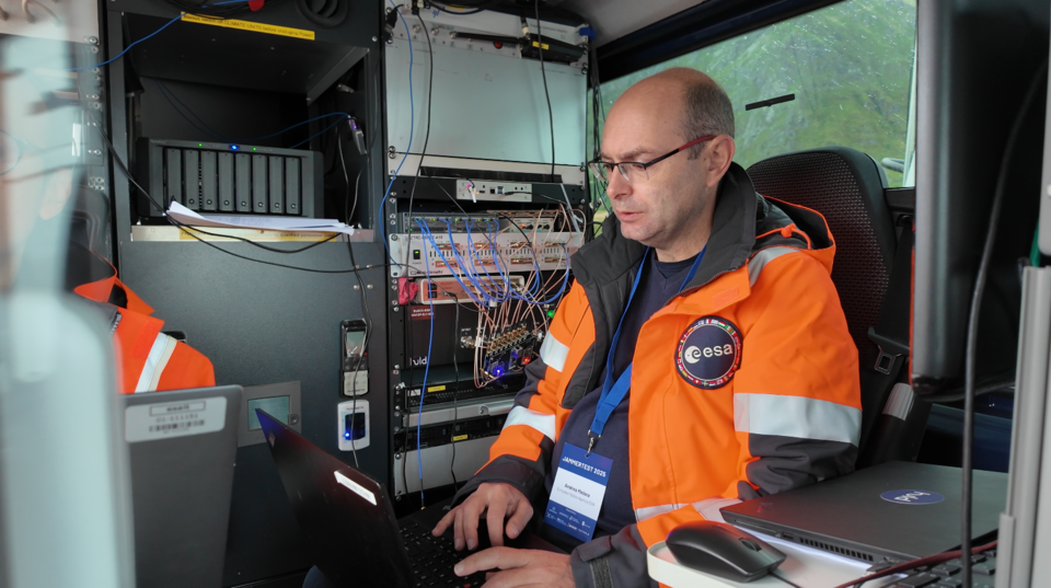
In its pursuit of strengthening European resilience in navigation, the European Space Agency (ESA) took part in Jammertest. Jammertest 2025 brought together 360 participants from 120 organisations across more than 20 countries, spanning academia, industry and governmental institutions.
Incidents of deliberate GNSS interference are on the rise, wih attacks happening daily worldwide. Disruptions threaten safe operations of energy grids, banking infrastructure, emergency transportation and civil aviation, with an outage potentially costing billions of euros daily for Europe.
Bleik on the island of Andøya offered a suitable setting for Jammerfest. (Image: ESA)
Jammertest. In a complex coordination exercise among seven Norwegian public authorities and facilitator Testnor, Jammertest organisers broadcast real satellite navigation interference for participants to observe how their equipment (on vehicles, drones, aircrafts, helicopters and vessels responds.
At nearly 70 degrees North and 300 km inside the Arctic Circle, the small village of Bleik on the island of Andøya offers the ideal setting for Jammertest. To the east, towering mountains act as natural barriers that contain disruptive signals, minimising their impact on civil society. To the west, its open coastline allows signals to be transmitted over the sea, supporting maritime participants in addition to air and land users.
The event’s test catalogue is extensive. Organisers simulate everything from simple handheld jamming to complex multi-source attacks launched from several locations simultaneously, including from mountaintops. “The goal is that every receiver is knocked out at some point during the campaign,” explains Tomas Levin, senior principal engineer at Norwegian Public Roads Administration and head of Jammertest.
“At Jammertest, the full GNSS chain sits along a table, from chip manufacturers to those developing the algorithms that run on them, to the companies building products around those chips and the ones integrating these products into larger systems,” Levin said.
ESA’s navigation and telecommunications testbed vehicles are custom-built mobile test platforms operated by ESA’s Navigation Laboratory to support test campaigns for navigation and telecommunications services, most notably Europe’s Galileo constellation. (Photo: ESA)
ESA engineers arrived with several missions. As in previous years, the team tested the robustness of EGNOS and Galileo signals when picked by a range of antennas, from simple mass-market ones found in smartphones to military-grade antennas, both stationary and mounted on a moving van.
A key objective was to test the performance of novel receiver technologies developed under various ESA programs, comparing them to current technologies. The team also tested equipment provided by industrial partners under ESA’s Third-Party services.
More than 100 TB of data were recorded and will support internal research. Moreover, these data can now be replayed at the ESA Navigation Laboratory, allowing industry to analyse how new equipment responds to real-world interference scenarios. (If you are interested in using ESA’s NavLab testing and consultancy services, fill out the contact form on the Consultancy and Testing page).
Finally, ESA also oversaw tests of new EGNOS ground receivers being developed by European industry under Horizon2020 and Horizon Europe programmes. These receivers aim to improve the system’s robustness in its next generation.
A multi-beam satellite navigation antenna test. (Photo: ESA)
Several projects tested at Jammertest by other participants were funded through NAVISP, highlighting the agency’s role in fostering innovation across the GNSS ecosystem.
“Jammertest is a unique opportunity,” concludes Derambure. “Here we have the edge of technology, the edge of testing scenarios. There is nowhere else where we can test this material in real conditions. I believe Jammertest will become a mandatory step for any new satellite navigation receiver technology.”
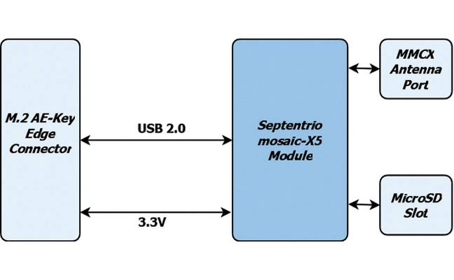
1. Precision card High-accuracy positioning with the mosaic-X5
The M.2 card GW16160 is the first Septentrio-based product from Gateworks, a U.S.-based manufacturer of single-board computers. The GW16160 provides reliable high-accuracy positioning powered by the mosaic-X5 GNSS module, a high-quality positioning solution for autonomous robots, UAVs and industrial mission-critical applications. The GW16160 allows engineers to integrate high-accuracy GNSS into edge systems without bulky external receivers or complex RF design. This ultra-low power card features an M.2 A/E-Key interface with USB 2.0 connectivity for plug-and-play integration. Gateworks, gateworks.com; Septentrio, septentrio.com
2. SPOOFING MITIGATION Can protect GPS, BeiDou and Galileo signals
Photo: TRIMBLE
The Trimble RTX-NMA (Navigation Message Authentication) mitigates spoofing attacks on GPS and BeiDou signals. RTX-NMA leverages the Trimble RTX correction service and enhances the security and integrity of GNSS navigation messages for all Trimble ProPoint receivers. Used in conjunction with Galileo OSNMA, users now have three constellations protected from spoofing attacks. Trimble RTX-NMA seeks to detect both fake GNSS signals and faulty ephemeris data through real-time authentication that ensures navigation messages from multiple RTX reference station receivers are genuine and trustworthy. It also encompasses faulty ephemeris detection, preventing unreliable data from being included in the correction stream. Enhanced security through advanced cryptographic techniques like AES encryption, and stream authentication, take it a step further. Trimble RTX-NMA is compatible with various Trimble GNSS receivers using firmware version 6.40 or greater. Trimble, trimble.com
A five-year research and development program has been launched to enhance GNSS navigation for aviation, encompassing security, integrity and spoofing resilience.
CMC Electronics is partnerinng with École de Technologie Supérieure (ÉTS) in Quebec, Canada, to create the CMC Electronics Industrial Research Chair in Resilient GNSS Navigation. The five-year chair, valued at more than $6 million, unites CMC’s avionics expertise, led by John Studenny, internationally recognized GNSS navigation expert and standards contributor, with ÉTS’s renowned LASSENA laboratory under René Jr. Landry, an expert in aerospace navigation and cybersecurity.
The chair will tackle critical threats to GNSS navigation for aviation, including jamming and spoofing. CMC and ETS aim to develop spoofing-resilient GNSS receivers capable of real-time detection, mitigation and total recovery from spoofing attacks, setting a benchmark in aviation safety and integrity.
Research focus areas
The chair’s work spans several integrated areas that target key GNSS security challenges:
integration of spoofing detection algorithms
spoofing resilience grading and stress testing frameworks
recovery mechanisms and certification benchmarking
advanced integrity algorithms (ARAIM)
sensor fusion and authentication technologies for spoofing mitigation
end-to-end spoofing-resilient GNSS prototype
next-generation inertial sensors with built-in integrity
Together, these areas aim to produce operational, spoofing-resilient GNSS systems suitable for aviation environments.
Broader impact and strategic alignment
The chair will train more than 65 highly qualified personnel (HQPs) and promote equity, diversity and inclusion in engineering. It supports initiatives to increase women’s representation and aligns with ÉTS’s strategic research fields in aerospace, cybersecurity, sensors and intelligent autonomous systems.
CMC Electronics is co-leading the research program and industrial deployment, ensuring that the outcomes are fast-tracked toward secure, export-ready GNSS solutions. Safran Trusted 4D contributes specialized expertise, and Jaunt Air Mobility provides operational insights for flight testing and system integration.