Category: Defense

  • Russia’s space-based nuclear weapon? Here’s an educated guess

    Russia’s space-based nuclear weapon? Here’s an educated guess

    Earlier this week House Intelligence Committee Chair Mike Turner sounded an alarm about a serious national security threat. It had to do with Russia, a weapon, space, and something nuclear.

    For many, these clues conjured up images of bombs falling to Earth from space, satellites destroyed by powerful electromagnetic pulses, shrapnel impacting the space station, and so on.

    Yet, putting nuclear weapons in space would be a clear violation of the 1967 Outer Space Treaty to which Russia and the United States are both signatories. It would also significantly increase East-West tensions at a time when Russia has enough tension and international condemnation to handle.

    Thursday evening the White House calmed the waters a bit by saying that Russia was pursing an anti-satellite weapon that cannot cause physical destruction on Earth.

    The most reasonable conclusion to draw from all of this is that Russia is closing in on its goal of having a nuclear-powered electronic warfare capability in space.

    Such a reusable weapon could be far more useful than any one-use nuclear explosive device.

    Threat = Intent + Capability

    A lengthy and detailed 2019 article on the site “Space Review” examined indications that Russia had begun construction of such a device. Titled “Ekipazh: Russia’s top-secret nuclear-powered satellite” it begins:

    “There is strong evidence from publicly available sources that a Russian company called KB Arsenal is working on a new type of military satellite equipped with a nuclear power source. Called Ekipazh, its mission may well be to perform electronic warfare [EW] from space.”

    The author, Bart Hendrickx, goes on to explain that development of such a weapon would be entirely in keeping with reported Russian government plans. Citing one Russian language source he says:

    “… the deployment of EW platforms in orbit would be in accordance with a policy for Russia’s electronic warfare program until 2020 approved by the Russian government in January 2012. A summary of this policy indeed mentions space-based electronic warfare as one of the objectives to be accomplished in the period before 2025. More specifically, it talks about the need to deploy ‘multifunctional space-based EW complexes for reconnaissance and suppression of radio-electronic systems used by radar, navigation and communications systems.’”

    When intelligence agencies assess the severity of a particular threat, they look at an adversary’s desire or intent to carry out a particular act, and their capability to do so. If the reporting is correct, Russia has intended to put a nuclear-powered EW satellite or spacecraft in orbit for some time. This week’s political dust up may mean that the decades of hard work described by Hendrickx in Space Review have paid off and given them the ability to do so.

    More Useful Than Orbiting Bombs

    The United States is far more dependent upon space than any other nation. As regular GPS World readers know, this is especially true for the essential positioning, navigation, and timing services that underpin virtually every technology.

    Destroying satellites would quickly lead to a shooting war that no one would want.

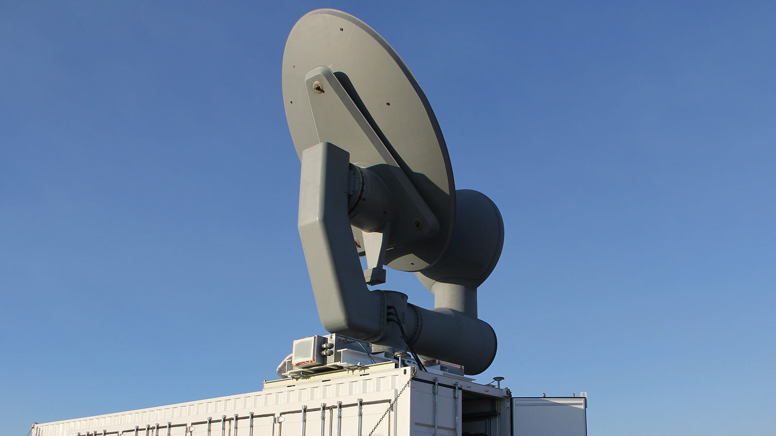
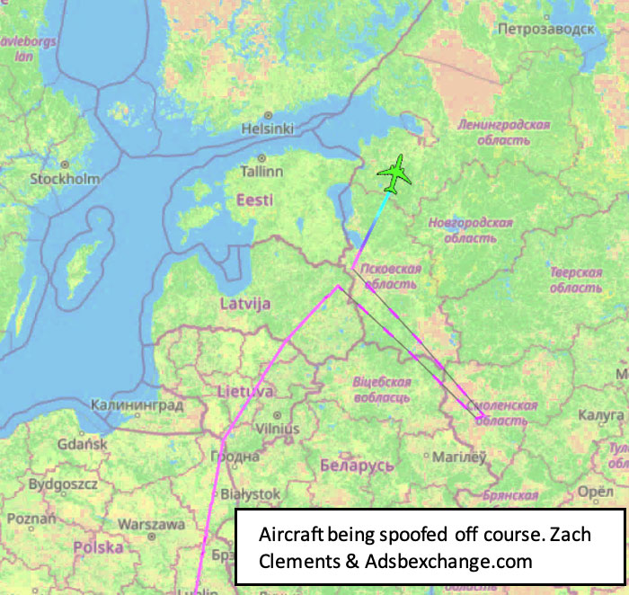
    On the other hand, electronic warfare doesn’t necessarily lead to casualties right away and is harder to recognize as actual warfare. For example, Russia has been attacking NATO countries, ships, and aircraft in the Baltic with GPS jamming and spoofing on and off since mid-December. No one has died (yet) and NATO, to the best of our knowledge, has not responded.

    Rather than destroying satellites, how much more useful is it to be able to temporarily disrupt the operation of one or more satellites? Or perhaps one type of satellite, such as GPS?

    Such attacks are reversable, so the attacked party is less likely to send bombs and bullets in return right away. And if the attacker gets what they want, or suddenly discovers they have gone a bit too far and are approaching a kinetic exchange, backing off is as easy as flipping a switch.

    Just the threat of being able to deny GPS or other satellite signals over a wide area would be useful.

    In fact, Russia has already made this kind of threat and it didn’t backfire.

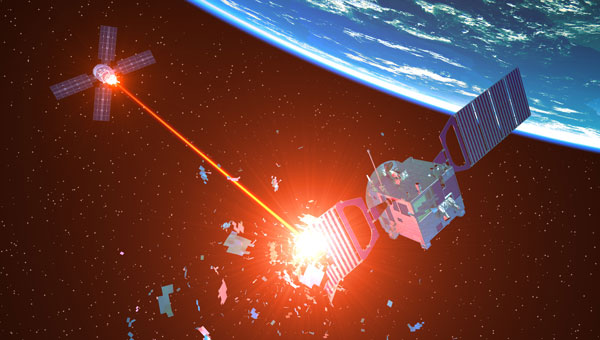
    In November 2021, prior to its invasion of Ukraine, Russia used a ground-based missile to destroy one of its own defunct satellites. Shortly thereafter Russian state-sponsored media claimed the demonstration “… means that if NATO crosses our red line, it risks losing all 32 of its GPS satellites at once.” Aside from a strong diplomatic tongue-lashing, there were few consequences. Additionally, wherever the “red line” was, it seems that NATO did not cross it.

    Nuclear Powered EW Most Likely

    It’s hard to know what more will be revealed, if anything, about this week’s dust-up over Russia, weapons, space, and nuclear.

    But Russia has long prided itself on its electronic warfare prowess. It sees EW as a counterbalance to the West’s dominance in high tech weapons and warfare.

    It is highly likely that Russia is executing its plans to extend this prowess and advantage into space with a nuclear-powered EW satellite.

    Whether or not this is the root Washington’s kerfuffle, the possibility should be an on-going concern for the United States.

    Our dependance on space makes us vulnerable. Our critical over-dependence on space for PNT, especially in light of the terrestrial PNT alternatives available to Russia and China, exposes our jugular and virtually invites attack.

    We have placed most of our eggs in the same basket — and there are too many ways in which it can be knocked to the ground.

    Until the United States establishes a resilient national PNT architecture, one with GPS at its center supported by other diverse and robust sources, we will continue to unintentionally encourage such things as space-based nuclear-powered electronic warfare and be at severe risk.

  • BAE Systems completes critical design review for M-Code GPS receiver

    BAE Systems completes critical design review for M-Code GPS receiver

    Image: BAE Systems
    Image: BAE Systems

    BAE Systems has completed the Critical Design Review (CDR) for its Military GPS User Equipment (MGUE) Increment 2 Miniature Serial Interface (MSI) program. This development is part of a $247 million contract awarded in 2020 by the U.S. Space Force.

    The MGUE Increment 2 MSI program is centered on the integration of a next-generation application specific integrated circuit (NG ASIC), which aims to improve the security and performance of M-Code technology. M-Code is designed to resist jamming and spoofing, which is crucial for military GPS applications. The NG ASIC technology also ensures compatibility with future BAE Systems M-Code GPS receivers.

    The MGUE Increment 2 program’s objectives include the development of an advanced, security-certified M-Code NG ASIC. This component is intended to provide reliable positioning, navigation, and timing (PNT) in GPS-challenged environments, incorporate multi-GNSS) robustness, and reduce power consumption for military applications in airborne, maritime, and ground domains.

    Additionally, the program aims to develop a small form-factor MSI GNSS receiver for applications that require low size, weight, and power (SWaP).

    The program is on track for completion in 2025, with deployment planned for the U.S. and its allies. The development is being conducted at BAE Systems’ facility in Cedar Rapids, Iowa.

  • RTX CHIMERA takes down UAVs during 3-week field test

    RTX CHIMERA takes down UAVs during 3-week field test

    Image: Raytheon
    Image: Raytheon

    The U.S. Air Force Research Laboratory (AFRL) and RTX, formerly Raytheon, have successfully completed a three-week field test of the CHIMERA high-power microwave (HPM) weapon at White Sands Missile Range in New Mexico. During the test, CHIMERA applied directed energy to multiple static target variations and demonstrated end-to-end fire control by acquiring and tracking UAVs and maintaining tracking for the entire flight path.

    The Counter-Electronic High-Power Microwave Extended-Range Air Base Defense system, known as CHIMERA, was built to fire highly concentrated radio energy at multiple middle-to-long-range targets. The ground-based demonstration system wields more power than other HPM systems to defeat airborne threats at the speed of light, according to Raytheon.

    CHIMERA is part of the Directed Energy Front-line Electromagnetic Neutralization and Defeat (DEFEND) program, which is a joint service effort to design, build and test HPM systems for front-line deployment. Raytheon is partnering with experts at the AFRL, Naval Surface Warfare Center Dahlgren Division, and the Undersecretary of Defense for Research and Engineering to complete this project.

  • 3 US troops killed, up to 34 injured in Jordan UAV strike linked to Iran

    3 US troops killed, up to 34 injured in Jordan UAV strike linked to Iran

    Image: NiseriN/ iStock / Getty Images Plus/ Getty Images
    Image: NiseriN/ iStock / Getty Images Plus/ Getty Images

    Three U.S. service members were killed and dozens wounded during a UAV attack on U.S. forces stationed in northeastern Jordan near the Syrian border, President Joe Biden and U.S. officials said on January 28.

    Biden blamed Iran-backed groups for the attack, the first deadly strike against U.S. forces since the Israel-Hamas war erupted in October 2023 and sent shock waves throughout the Middle East.

    “While we are still gathering the facts of this attack, we know it was carried out by radical Iran-backed militant groups operating in Syria and Iraq,” Biden said in a statement.

    At least 34 personnel were being evaluated for possible traumatic brain injury, a U.S. official told Reuters, speaking on the condition of anonymity. Two officials said some wounded U.S. forces were medically evacuated from the base for further treatment.

    The Islamic Resistance in Iraq – an umbrella organization of Iran-backed militant groups — claimed attacks on three bases, including one on the Jordan-Syria border.

    The attack is a major escalation in the already tense situation in the Middle East, where war broke out in Gaza after the Palestinian Islamist group Hamas attacked Israel on October 7, killing 1,200 people. Israel’s subsequent assault on Gaza has killed more than 26,000 Palestinians as of January 2024, according to the local health ministry.

    Since then, U.S. forces have come under attack more than 150 times by Iran-backed groups in Iraq and Syria. U.S. warships have also been fired at by Iran-backed Houthi forces in Yemen, who are regularly attacking commercial ships passing through Red Sea waters off Yemen’s coast.

    While the United States has maintained an official line that Washington is not at war in the region, it has been retaliating against the Iran-backed groups in Iraq and Syria and carrying out strikes against Yemen’s Houthi military capabilities.

    Referring to the fallen soldiers, in his statement released by the White House Biden said: “We will carry on their commitment to fight terrorism. And have no doubt — we will hold all those responsible to account at a time and in a manner of our choosing.”

  • Turkish Armed Forces add UAVs to their reconnaissance capabilities

    Turkish Armed Forces add UAVs to their reconnaissance capabilities

    Image: HAVELSAN
    Image: HAVELSAN

    The Turkish Armed Forces have added the BAHA autonomous sub-cloud UAV to their reconnaissance capabilities. The UAV can be used for tracking, detection, area protection, intelligence and electronic warfare.

    The BAHA, developed by Turkish defense company HAVELSAN, is an independent sub-cloud UAV equipped with vertical take-off and landing (VTOL) capabilities. It has complete autonomy in mission execution and allows for the integration of diverse payloads.

    With the ability to execute missions at altitudes of up to 15,000 feet, the BAHA has a maximum flight duration of six hours with a gas engine and covers a range of up to 80 kilometers. It also features a 5-kilogram payload capacity and a 3.7-meter wingspan. The system, designed for quick deployment by two individuals and operation by a single person, can be mission-ready within minutes, according to HAVELSAN.

    Tested in various regions, challenging climates, and operational conditions, the system has been improved based on feedback from security forces.
    HAVELSAN has achieved export success with the BAHA in Africa and Central Asia this year. After successful tests, it is now available for domestic use by security forces.

  • From Russia with love for Christmas: Jamming Baltic GPS

    From Russia with love for Christmas: Jamming Baltic GPS

    Actions likely in response to U.S. and NATO moves

    Image: GPSJam.org
    Image: GPSJam.org

    Parts of Poland, Lithuania, southern Sweden, and other countries in the Baltic region had an unexpected Christmas present this year. GPS signals were disrupted and not available in many areas on the 25th and 26th of December. Poland seemed to be particularly impacted, with the northern two-thirds of the country affected and many users on the ground and in the air having to make do without reliable service.

    On New Year’s Eve, parts of Finland experienced significant jamming as well. The most visible impacts of the holiday events were seen in aviation and low navigation integrity reports from ADS-B systems. These were displayed on the GPSJam.org website.

    Experts in the United States and Poland point to Russia as the source of the interference. They say that Russian anger over the activation of a U.S. anti-missile system in northern Poland in mid-December, and Sweden’s progress toward NATO membership with a recent positive vote in the Turkish Parliament were likely motivations.

    Such a reaction by Russia is not unprecedented. In 2022 President Putin threatened Finland and Sweden with invasion if they sought to join NATO. Subsequently, Finnish President Niinistö met with President Biden to discuss improving defense ties. Shortly thereafter planes flying over Kaliningrad and nearby areas in the Baltic began reporting GPS jamming. Analyses of the event by graduate students at the University of Texas Radionavigation Laboratory and Stanford University have provided some details and will likely reveal more as time goes by.

    Zach Clements at U.T. studied the disruption and discovered that it included several transmitters spread across a wide area. Some were simply jamming GPS signals to deny service. At least one transmitter was spoofing aircraft so their instruments would show them far from their actual location.
    While the phenomenon known as “circle spoofing” has been frequently observed with ships, this was the first time it was reported in aviation. With circle spoofing a receiver is electronically captured and “moved” to a different location. Then it is made to appear to move in circles, almost always in a clockwise direction

    Image: Zach Clements/ GPSJam.org
    Image: Zach Clements/ GPSJam.org

    Clements is reasonably sure the source of the circle spoofing was inside Russia. “The points at which the aircraft began to be impacted by the spoofing and where they regained authentic GPS indicate that the spoofer is somewhere in Western Russia. Interestingly, the location to which the aircraft were spoofed is a field about a kilometer from Russia’s decommissioned Smolensk military airbase.”

    Clements’ previous research has demonstrated how sources of GPS disruption can be located by satellites in low-Earth orbit.

    Zixi Liu at Stanford has discovered that the interference was actually two separate events. The first lasted from 9:30 PM on the 24th until 4:30 AM on the 25th, with the second beginning around 2:30 PM on the 25th and tapering off around midnight on the 26th.

    Liu’s previous research used aviation ADS-B data to geo-locate sources of GPS disruptions. She is continuing to examine these incidents to see whether the locations of one or more of the jammers can be determined.

    Aviation interests have become increasingly concerned about interference with GPS signals since 2019 when a commercial passenger aircraft flying through smoke nearly impacted a mountain. Since then, aviation groups have raised the issue, national authorities have been regularly issuing warnings, and the UN’s International Civil Aviation Organization has urged its member nations to take action to prevent interference.

    Intentional jamming and spoofing seem to be getting much more frequent, though, especially in and around conflict areas. In April, Eurocontrol, the European air traffic control organization, warned its members and aircraft using its airspace about these increasing trends.

    This fall a spate of aircraft being spoofed in the Middle East, and in at least one instance nearly entering Iranian airspace without clearance, caused particular alarm.

    “Aviation is always at greater risk when GPS signals are not available or are compromised in some way,” according to Joe Burns, a senior captain at a major international air carrier. Burns is also a member of a board that advises the U.S. government on GPS and related issues. “Interference with GPS increases the risks of accidents and almost always slows the system down, makes flights longer, and more expensive,” he said.

    The International Air Transport Association is meeting this month to discuss GPS interference. Most agree, though, that most meaningful short-term solutions will depend upon the cooperation of national governments across the globe.

  • SiTime Corporation launches PNT platform

    SiTime Corporation launches PNT platform

    Image: SiTime Corporation
    Image: SiTime Corporation

    SiTime Corporation, a precision and timing company, has released its Endura Epoch Platform. The platform is designed to provide robust and resilient positioning, navigation and timing (PNT) services critical in defense operations.

    The MEMS oven-controlled oscillator (OCXO) can boost the resilience of PNT systems and other equipment, including radars, field and airborne radios, satcom terminals and avionics against spoofing, jamming and other disruptions in GPS signals.

    Building off of the Epoch Platform launched in September 2023, the Endura Epoch MEMS OCXOs are designed to meet the challenging shock and vibration conditions found in aerospace and defense. These devices are manufactured using proven semiconductor processes that deliver the reliability and quality expected from silicon devices that cannot be achieved by quartz crystal OCXOs, especially in extreme conditions.

    The Endura Epoch Platform MEMS OCXO greatly simplifies timing system design due to superior performance and delivers a significant improvement in size, weight and power (SWaP). Key features and benefits compared to quartz crystal OCXOs include:

    • Programmable frequencies from 10 to 220 MHz
    • Rated at 20,000 g shock survivability
    • Up to 20 times better frequency stability over temperature
    • Up to 3 times better Allan deviation, a measure of short-term frequency stability
    • Surface-mountable, small footprint and low height 9.0 mm x 7.0 mm x 3.6 mm
    • Low weight of 0.35 g
    • 420 mW steady state power
  • More about eVTOLs

    More about eVTOLs

    Airbus is working with a team to develop a “hybrid” approach to electric aircraft, which means that their experimental aircraft is not only using electric power — with electric motors and propellors (propulsers), an 800-volt battery, and a hi-voltage distribution and control system. It also has a conventional turbine which supplies torque to a conventional propeller and generates electrical power to maintain charge for the 800-volt battery.

    Airbus EchoPulse demo aircraft. (Photo: Airbus/EchoPulse)
    Airbus EchoPulse demo aircraft. (Photo: Airbus/EchoPulse)

    The team working with Airbus includes Daher, which has modified its TBM 900 turboprop aircraft to add the electrical system, motors and props supplied by Safran. Airbus has developed the 800-volt battery and the Flight Control System for the aircraft, through which any future autonomous capability would likely be brought about.

    The decision to try this ‘hybrid’ approach may have been influenced by Volvo, which is pressing this approach for the Series 90 and 60 of its hybrid Electric Vehicles (EV). Combining recharging by an internal combustion engine with a battery and electric drive system greatly extends the range of this model, greatly reduces its gas consumption, and minimizes the hunt for rare recharging outlets.

    It would seem that the principal benefit from the Airbus team development could be the 800-volt DC battery design, and the high voltage distribution/control/recharging system when they are potentially spun off and applied to other manned/unmanned eVTOL passenger aircraft. The basic problem for eVTOL aircraft is payload and range – is that something that a huge energy reservoir such as this battery system could support?

    Airbus EchoPulse demo aircraft. (Photo: Airbus/EchoPulse)
    Airbus EchoPulse demo aircraft. (Photo: Airbus/EchoPulse)

    Developed by Airbus Defense and Space in Toulouse, France, the 800-volt DC battery system delivers up to 350 kilowatts to the electric system on the aircraft. The battery was derived from earlier versions that were flown on Airbus CityBus eVTOL demonstrator and FlightLab helicopters. The Lithium-ion battery weighs in at 350 kg (772 lbs.) and is mounted in an enclosure of the belly of the EcoPulse demonstration aircraft.

    Airbus reportedly plans on taking this high energy-density battery into its commercial aircraft business. But the main market could be for hybrid eVTOL aircraft, which can carry this heavy battery and its control system and to benefit from the massive energy density.

    Meanwhile, as the Russian-Ukrainian war drags on with both sides throwing at each other increasing numbers of ‘kamikaze’ UAVs carrying explosives, interest has recently been growing around a 2020 report out of St. Petersburg Electro-technical University in Russia that critiques the Russian air defense system. According to the report, these defenses are poorly adapted to detect or destroy vehicles as small and slow-moving as UAVs.

    Ukrainian UAV troops were only recently pictured assembling weaponized drones for their one-way trip to Russian-owned targets.

    Photo released by General Staff of the Armed Forces of Ukraine on Telegram
    Photo released by General Staff of the Armed Forces of Ukraine on Telegram

    The explosive carriers are frequently simple racing UAVs. In one released photo, an inexpensive quadcopter is taped together with plastic explosives and an RPG warhead using adhesive tape. Nothing has to be very durable, just durable enough to last for its short one-way trip through Russian defenses.

    The Russian air defenses rely on several tracked and/or wheeled mobile systems using both guns and missiles. This includes radar-guided and heat-seeking missiles, such as the Pantsir-S1, the Tunguska, the Tor, the Strela-10, and the Igla-S man-portable missiles, all of which are designed to combat high-speed jet aircraft, helicopters, and cruise missiles. At the same time, UAVs are slow and very small in comparison.

    Unfortunately, the missiles ‘ poor target detection capability and detonation control systems appear to be the culprits for the inability to strike down UAVs. Tor radar has been seen to only detect at 3-4km (1.8 -2.5 miles), while the minimum operating range is about the same. Thus, misses are reportedly more likely than taking out attacking drones. While the system may be somewhat ineffective, the cost of using missiles is huge.

    A Ukrainian UAV recording within close range of a Russian Tor defense system has captured video of a missile hurtling past and failing to bring it down. Similar results have been found with both the Pantsir-S1 and Tunguska defense systems.

    For the close-in gun and cannon defense systems, Russian tests demonstrated that to raise the probability of a direct hit to just 50% for an attacking drone at a distance of 1.3 miles, between four to 13 thousand shells would need to be fired.  This is significantly more ammunition than one Tor system can fire in one volley without reloading, even at 5,000 rounds/minute of which it is capable.

    Ukrainian war strategists continue to acquire thousands of UAVs each month, while its troops continue to throw them against their Russian invaders with improvised explosive payloads. Meanwhile, as of December 2023, Congress is continuing negotiations over another $61.4 billion in funding to further Ukraine’s war efforts, even while President Zelenskyy visited Washington to urge the U.S. to maintain its support.

    The problem with this situation is that both sides have learned that UAV warfare’ is simpler, less dangerous for the aggressor, and less costly than regular offensives. Thus, a stalemate might prolong the war for even longer.


    So, on the commercial, peaceful side of drone development, the possibility of a hybrid-electric approach for eVTOL passenger-carrying autonomous vehicles is making progress. Nevertheless, as the war continues in Ukraine, could the reduced cost of UAV warfare’ possibly prolong it?

  • Origin stories: Champions of GPS share beginnings, breakthroughs and what’s next

    Origin stories: Champions of GPS share beginnings, breakthroughs and what’s next

    Image: Defense Visual Information Center
    Image: Defense Visual Information Center

    As part of our celebration of the 50th anniversary of the Global Positioning System, three long-time players in the industry share their “GPS origin story,” recent breakthroughs, and their view on the next 50 years of positioning, navigation and timing (PNT). All three began their involvement with GPS between the late 1970s and the late 1980s, before the system was completed. All three are continuously making GPS more resilient and resistant to jamming and spoofing or augmenting it with layered multi-orbit architectures of complementary PNT.

    Read the origin stories, recent breakthroughs, and more insights from the following companies:

    BAE Systems: Pioneering military GPS technology

    Northrop Grumman: Integrating and developing GPS technology

    Spirent: From testing GPS to assuring PNT

  • Pioneering military GPS technology

    Pioneering military GPS technology

    Image: BAE Systems 
    Image: BAE Systems

    What is BAE Systems’ GPS origin story?

    BAE Systems has more than 45 years of military GPS experience. In fact, the first ever GPS signal reception on Earth happened at one of our offices in Cedar Rapids, Iowa, on July 19, 1977, when one of our legacy companies received the signal. Since that historic day, BAE Systems’ engineers have introduced more than 50 GPS products, including GPS anti-jam and precision landing systems.

    As a pioneer in military GPS technology, BAE Systems has delivered nearly two million GPS devices on more than 280 platforms around the world. We design and produce advanced GPS technology compatible with the next generation M-code signal, improving security and anti-jamming capabilities for critical defense applications.

    Can you share any recent innovations from BAE Systems?

    BAE Systems innovates a full portfolio of M-code-compatible military GPS solutions to meet warfighters’ needs. Our Strategic Anti-jam Beamforming Receiver — M-code (SABR-M) is the most capable integrated anti-jam (AJ) electronics GPS receiver and the first integrated AJ M-code receiver available for weapons systems. It delivers assured, global position, velocity, altitude and timing, as well as strong protection against GPS signal jamming and spoofing — critical capabilities for unmanned aerial vehicles (UAVs), precision-guided munitions (PGMs), and missiles in threat environments.

    This past June, at the Joint Navigation Conference in San Diego, BAE Systems unveiled NavGuide, a next-generation Assured Positioning, Navigation and Timing (A-PNT) device featuring M-code GPS technology. It is our response to strong defense market demand for a cost-effective, high performance handheld GPS upgrade. NavGuide provides an intuitive user interface and integrates easily into platforms currently using BAE Systems’ Defense Advanced GPS Receiver (DAGR).

    How is your company preparing for the next 50 years of PNT with GPS and beyond?

    BAE Systems is making advancements in our critical navigation capabilities for the warfighter through the Military GPS User Equipment (MGUE) Increment 2 program. We are developing a Next-Generation Application Specific Integrated Circuit (NG ASIC) for our small form factor Miniature Serial Interface (MSI) receiver. This will enhance our full portfolio of ground, airborne and weapons M-code assured GPS receivers beyond 2030.

    We have invested an enormous amount of time and energy into our facilities and simulator capabilities, especially in our state-of-the-art simulators powered by Spirent Federal signal generation and RF wavefront technology. We want to be prepared to meet the technical demands of an ever-changing threat environment, and we need to be certain our receivers are prepared for the fight the first time, every time. We put our receivers through the paces by running them through thousands of trials on our Spirent simulators to validate and verify our performance under the most demanding scenarios.

  • Integrating and developing GPS technology

    Integrating and developing GPS technology

    Image: Northrop Grumman
    A flight test of Northrop Grumman’s airborne navigation solution, embedded GPS/INS modernization, EGI-M (Image: Northrop Grumman)

    What was Northrop Grumman’s GPS Origin Story?

    Northrop Grumman’s involvement with GPS has its origins during the mid-1980s, when we became an early adopter. We applied our prior decades of technical expertise in defense and commercial navigation solutions to recognize the significance of GPS as an emerging technology to optimize our inertial navigation products. The first GPS receiver was integrated with the LN-33, our main product for military aircraft, in 1987.

    Around the same time, our engineers began to develop an indigenous civil GPS receiver to complement our inertial navigator for use in commercial airliners. This resulted in the certification and fielding of the LTN-2001 product, an eight channel C/A Code GPS receiver. This receiver, in concert with our Autonomous Integrity Monitored Extrapolation (AIME) algorithm, provided our customers a first-ever sole means navigation system using GPS/inertial for non-precision approach.

    By the early 1990s, advancements in the semiconductor industry facilitated the reduction of the GPS receiver from a 1,000 cu in stand-alone box to a roughly 6-in by 6-in circuit card. This critical milestone allowed GPS to be embedded into an inertial navigation system (INS) without a significant increase in its size or power consumption and thereby the ubiquitous Embedded GPS INS (EGI) was born. Our first inertial navigation system with embedded military GPS capability was the LN-100G in 1991. This standard form factor was produced across the industry with installations on virtually all the front-line tactical aircraft and rotorcraft for the U.S. Department of Defense (DOD) and many of our allies.

    Can you share a breakthrough?

    Inspired by accomplishments in the survey community, our team conducted early location accuracy experiments to demonstrate a few decimeters of accuracy between our Woodland Hills, California, location and a facility in San Jose, California, about 500 km away. Leveraging this experience and the same signal processing, our teams became a broader solution provider for adjacent mission applications including precise formation flying for in-flight automated refueling, precision approach and landing, and decimeter-level positioning for the intelligence, surveillance and reconnaissance (ISR) community.

    LN-100G. (Image: Northrop Grumman)
    LN-100G. (Image: Northrop Grumman)

    In parallel with these developments, Northrop Grumman, in partnership with the Defense Advanced Research Projects Agency (DARPA), improved the resilience of embedded GPS receivers with a more intimate coupling of INS and GPS. The DARPA GPS Guidance Package (GGP) program demonstrated a Navigation Grade Fiber Optic Gyro (FOG), greatly improved GPS tracking performance under extreme vehicle dynamics, and the ability to track at lower signal-to-noise levels. Our success on this program reinforced our reputation as a GPS integration leader and led to the introduction of Northrop Grumman’s current LN-251 product line, which is broadly used in tactical military aircraft.

    In the early 2000s, Northrop Grumman initiated research into the feasibility of a Global Navigation Satellite System (GNSS) software-defined radio and started development of what we now call SERGEANT (Software Enabled Reconfigurable GNSS Embedded Architecture for Navigation and Timing). The company used Spirent signal simulators to evaluate proper GPS M-code tracking over a wide range of test cases in a controlled laboratory environment. Together with the Air Force Research Laboratory (AFRL), Northrop Grumman demonstrated advanced receiver capabilities using SERGEANT starting in 2010. In 2018, AFRL used SERGEANT for the first real-time flight demonstration of a GPS M-code SDR.

    How is your company preparing for the next 50 years of PNT with GPS and beyond?

    SERGEANT Flight Test SDR. (Image: Northrop Grumman)
    SERGEANT Flight Test SDR. (Image: Northrop Grumman)

    Northrop Grumman foresees the world of GNSS being dramatically influenced by the emergence of alternative radio navigation sources as augmentations to traditional GNSS constellations to provide additional robustness and resilience. Our PNT SDR technology is a foundational tool to integrate these emerging radio navigation signals quickly and accelerate deployment to our customers.

    Northrop Grumman has led medium-Earth orbit (MEO) and low-Earth orbit (LEO) PNT technology studies through the DARPA Blackjack proliferated LEO (pLEO) program, starting in 2017. Northrop Grumman’s SERGEANT SDR transceiver is currently being integrated for use in emerging pLEO constellations. We anticipate that these capabilities, as well as emerging cooperative radio navigation signals, will become a critical part of the next 50 years of PNT with GPS.

  • From testing GPS to assuring PNT

    From testing GPS to assuring PNT

    A Spirent user employs a portable GSS6450 attached to an antenna to record GPS, other GNSS, and complementary signals for resilient PNT testing. (Image: Spirent)
    A Spirent user employs a portable GSS6450 attached to an antenna to record GPS, other GNSS, and complementary signals for resilient PNT testing. (Image: Spirent)

    What is Spirent’s GPS origin story?

    Spirent’s GPS genesis began on a rooftop in the middle of the night in the early 1980s. Engineers were attempting to acquire the new GPS signals with their receivers, scheduling their lives around the times when satellites would pass overhead, angling antennas off a roof in the dark, and hoping for favorable conditions. Those difficulties inspired an idea: since real-world conditions are never the same twice, simulating the signals in a lab would control variables and provide repeatable and trustworthy results.

    That idea grew to be Spirent’s positioning division — a team of experts whose sole focus is to partner with customers to accelerate the deployment of robust PNT technology. In 1985, one of the first groundbreaking simulators provided to a customer generated six GPS L1/L2 signals. Soon after, we developed the world’s first simulator with SA-A/S capability, establishing our reputation for innovation. Today, simulation is for much more than convenience. The further upstream testing starts, the better for R&D and investment decisions. Because of that, we work across the spectrum in close partnership with constellation developers, receiver manufacturers, and OEM application integrators.

    Can you share a recent breakthrough?

    GPS regional military protection (RMP) is a nascent anti-jamming capability that uses a steerable, narrow-beam M-code signal, allowing U.S. and allied forces to operate much closer to interference without losing connection. Spirent supports RMP, so modernized GPS user equipment (MGUE) can be tested and integrated with RMP long before live-sky signals are available.
    Another major breakthrough is in AltNav, a catch-all term that includes non-GNSS sources of RF and other complementary PNT, with recent attention focused on low-Earth orbit (LEO) constellations. Spirent has developed LEO AltNav simulators for both the military and commercial sectors that seamlessly integrate with Spirent’s extensive testbed for GNSS, threat simulation, inertial navigation systems, and additional complementary PNT.

    How is your company preparing for the next 50 years of PNT with GPS and beyond?

    As a trusted industry test partner, one of Spirent’s guiding principles over the past five decades has been to support PNT developers and early adopters by being first-to-market with new signals and constellations. Enabled by our flexible solutions, our dedication to that tenet will continue across the next five decades.

    NAVWAR resilience testing is an area where emerging test needs will continue to demand more from the test environment. Layered PNT positioning engines — including GNSS, secure military signals, CRPA systems, multi-orbit architectures, and sensor fusion — are driving complexity in the test regimes that support them. Spirent’s purpose-built solutions are designed to meet these advancements, with deterministic simulation that delivers definitive validation and accurate test results.

    Spirent pioneered the use of software-defined radios for GNSS simulation with the GSS9000, which enabled the same architecture to support new signal types, higher motion rates, user-defined waveforms, and more than double the generated signals. The next generation will extend that flexibility, capacity, and ease of integration to future complementary PNT sources while maintaining system performance across physical and virtual realms.