Tag: Northrup Grumman

  • Lighthouses on land and in the sky

    Lighthouses on land and in the sky

    Matteo Luccio
    Matteo Luccio

    When Boston Light — an 89 ft-high, white lighthouse on Little Brewster Island in Boston’s outer harbor — opened in September 1716, it was the first one in the Thirteen Colonies. Sally Snowman, who has been its keeper for most of the past two decades, is the last official lighthouse keeper in the United States. Contemplating the horrible trips across the Atlantic on merchants’ galleons, when many gale-tossed passengers despaired of ever setting foot on land again, she recently commented: “Imagine what they felt when they spotted the light.” See Dorothy Wickenden’s article “Last Watch” in the November 6, issue of my favorite magazine, The New Yorker. Of the roughly 850 lighthouses currently in the United States, Wickenden reported, only about half serve as active aids to navigation and the U.S. Coast Guard has automated all of them. “The rest,” Wickenden wrote, “have been made obsolete by GPS.” Yet, she pointed out, even hardheaded ship captains and pilots say that “lighthouses still have a place.”

    When Snowman retires at the end of this month, it will mark the end of an era that lasted more than three centuries. This month also marks the 50th anniversary of the approval of Navstar GPS (as it was originally called) by the Defense Systems Acquisition Review Council (DSARC) of the U.S. Department of Defense. Three months earlier, at the meeting now remembered as Lonely Halls (see my editorial in the September issue), Brad Parkinson and his team had made the key decisions about the system’s architecture, including the number of satellites, their orbits, and what kinds of signals to use.

    In this month’s issue, we revisit how, after initial opposition, the U.S. armed forces adopted GPS; how the civilian/commercial GPS (now GNSS) industry was born; and how surveyors reacted to this disruptive new technology.

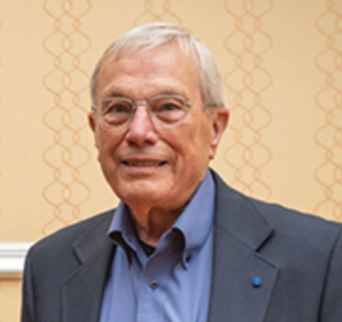
    To answer the first question, I asked Gaylord Green, who was on Parkinson’s team and later led the GPS Joint Program Office, to write his recollections on the subject. I also interviewed Marty Faga, whose long and distinguished career included four years as both Director, National Reconnaissance Office and Assistant Secretary for Space, U.S. Air Force. Faga passed away on October 19. To answer the second question, I turned to Charlie Trimble, who in 1978 co-founded the company named after him and was its CEO until 1998. To answer the third question, I chose Dave Zilkoski, who earned a master’s degree in geodetic science in 1979, the year after the first GPS satellite was deployed, while working for the National Geodetic Survey, of which he was later the director for about three years. Many readers of this magazine also know Zilkoski as the regular contributor to one of our four digital newsletters, Survey Scene.

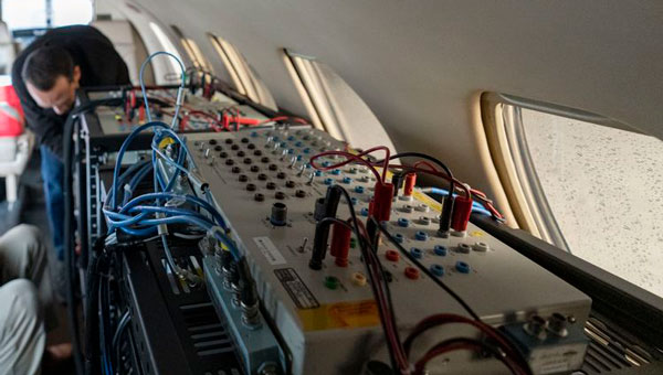
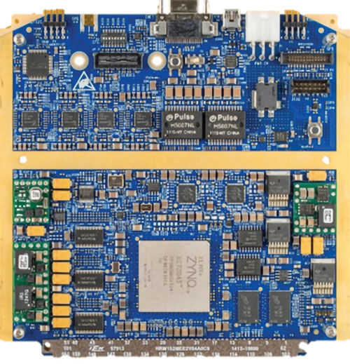
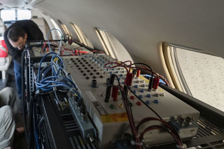
    This issue’s cover story also focuses, in part, on the 50th anniversary of GPS, as seen by three large players in the aerospace industry: Spirent, BAE Systems, and Northrop Grumman.

    Matteo Luccio | Editor-in-Chief
    [email protected]

  • Integrating and developing GPS technology

    Integrating and developing GPS technology

    Image: Northrop Grumman
    A flight test of Northrop Grumman’s airborne navigation solution, embedded GPS/INS modernization, EGI-M (Image: Northrop Grumman)

    What was Northrop Grumman’s GPS Origin Story?

    Northrop Grumman’s involvement with GPS has its origins during the mid-1980s, when we became an early adopter. We applied our prior decades of technical expertise in defense and commercial navigation solutions to recognize the significance of GPS as an emerging technology to optimize our inertial navigation products. The first GPS receiver was integrated with the LN-33, our main product for military aircraft, in 1987.

    Around the same time, our engineers began to develop an indigenous civil GPS receiver to complement our inertial navigator for use in commercial airliners. This resulted in the certification and fielding of the LTN-2001 product, an eight channel C/A Code GPS receiver. This receiver, in concert with our Autonomous Integrity Monitored Extrapolation (AIME) algorithm, provided our customers a first-ever sole means navigation system using GPS/inertial for non-precision approach.

    By the early 1990s, advancements in the semiconductor industry facilitated the reduction of the GPS receiver from a 1,000 cu in stand-alone box to a roughly 6-in by 6-in circuit card. This critical milestone allowed GPS to be embedded into an inertial navigation system (INS) without a significant increase in its size or power consumption and thereby the ubiquitous Embedded GPS INS (EGI) was born. Our first inertial navigation system with embedded military GPS capability was the LN-100G in 1991. This standard form factor was produced across the industry with installations on virtually all the front-line tactical aircraft and rotorcraft for the U.S. Department of Defense (DOD) and many of our allies.

    Can you share a breakthrough?

    Inspired by accomplishments in the survey community, our team conducted early location accuracy experiments to demonstrate a few decimeters of accuracy between our Woodland Hills, California, location and a facility in San Jose, California, about 500 km away. Leveraging this experience and the same signal processing, our teams became a broader solution provider for adjacent mission applications including precise formation flying for in-flight automated refueling, precision approach and landing, and decimeter-level positioning for the intelligence, surveillance and reconnaissance (ISR) community.

    LN-100G. (Image: Northrop Grumman)
    LN-100G. (Image: Northrop Grumman)

    In parallel with these developments, Northrop Grumman, in partnership with the Defense Advanced Research Projects Agency (DARPA), improved the resilience of embedded GPS receivers with a more intimate coupling of INS and GPS. The DARPA GPS Guidance Package (GGP) program demonstrated a Navigation Grade Fiber Optic Gyro (FOG), greatly improved GPS tracking performance under extreme vehicle dynamics, and the ability to track at lower signal-to-noise levels. Our success on this program reinforced our reputation as a GPS integration leader and led to the introduction of Northrop Grumman’s current LN-251 product line, which is broadly used in tactical military aircraft.

    In the early 2000s, Northrop Grumman initiated research into the feasibility of a Global Navigation Satellite System (GNSS) software-defined radio and started development of what we now call SERGEANT (Software Enabled Reconfigurable GNSS Embedded Architecture for Navigation and Timing). The company used Spirent signal simulators to evaluate proper GPS M-code tracking over a wide range of test cases in a controlled laboratory environment. Together with the Air Force Research Laboratory (AFRL), Northrop Grumman demonstrated advanced receiver capabilities using SERGEANT starting in 2010. In 2018, AFRL used SERGEANT for the first real-time flight demonstration of a GPS M-code SDR.

    How is your company preparing for the next 50 years of PNT with GPS and beyond?

    SERGEANT Flight Test SDR. (Image: Northrop Grumman)
    SERGEANT Flight Test SDR. (Image: Northrop Grumman)

    Northrop Grumman foresees the world of GNSS being dramatically influenced by the emergence of alternative radio navigation sources as augmentations to traditional GNSS constellations to provide additional robustness and resilience. Our PNT SDR technology is a foundational tool to integrate these emerging radio navigation signals quickly and accelerate deployment to our customers.

    Northrop Grumman has led medium-Earth orbit (MEO) and low-Earth orbit (LEO) PNT technology studies through the DARPA Blackjack proliferated LEO (pLEO) program, starting in 2017. Northrop Grumman’s SERGEANT SDR transceiver is currently being integrated for use in emerging pLEO constellations. We anticipate that these capabilities, as well as emerging cooperative radio navigation signals, will become a critical part of the next 50 years of PNT with GPS.

  • Lockheed Martin, Northrop Grumman land OTAs for US Army

    Lockheed Martin, Northrop Grumman land OTAs for US Army

    Image: CT757fan/E+/Getty Images
    Image: CT757fan/E+/Getty Images

    The U.S. Army has awarded Lockheed Martin and Northrop Grumman other transaction agreements (OATs) for the first phase of the Launched Effects (LE) program.

    Launched Effects “will provide standoff sense and effect capabilities for soldiers while keeping air and ground forces outside the range of adversary weapon systems,” according to the service’s Program Executive Office for Intelligence, Electronic Warfare and Sensors. It also said LE will also support forces entering and exiting mission areas. 

     Northrop has been awarded for two payloads and Lockheed Martin has been awarded for one, with each award valued at about $100,000, according to the Army. The OTA will total about $37 million over all three phases. 

     The LE program consists of three phases. During that span, the Army aims to mature payloads from a technology readiness level of 6, a prototype system that has been tested in a relevant environment, to TRL 7, a prototype that has been demonstrated in an operational environment. 

     Launched effects have been successfully tested by the Army in the past, including at Project Convergence. In January 2023, General Atomics Aeronautical Systems announced its Eaglet launched-effect flew for the first time, dropping off an Army-owned Gray Eagle Extended Range UAV during a demonstration in Utah. 

  • EAB Q&A: Could a new PNT constellation replace GNSS?

    EAB Q&A: Could a new PNT constellation replace GNSS?

    “Could a new PNT constellation using LEO satellites fully replace the services provided by the four existing GNSS constellations?”


    Mitch Narins
    Mitch Narins

    “From a pure capabilities standpoint, the answer is “Yes”. LEO constellations can provide the PNT performance metrics that users require. However, should this strategy be followed, it would lack the diverse, complementary solutions needed to ensure the safety, security, and efficiency of critical infrastructure. Many have recognized the need for resilient PNT solutions and identified system-of-systems approaches. Multiple satellite constellations — MEOs and LEOs (despite the number of platforms) — lack this needed resilience. A resilient system-of-systems should include satellites in multiple orbits and complementary ground-based PNT infrastructure, each providing needed performance and overall demonstrating resilience from diverse threats.”

    — Mitch Narins
    Strategic Synergies


    Photo: Orolia
    John Fischer

    “In theory, yes. With a much stronger signal (antijam) that is encrypted (antijam), they counter GNSS’s two main vulnerabilities. However, with a paid service business model, it is difficult to compete with a free service. Moreover, large constellations are needed to overcome GDOP. OneWeb, Starlink, et al. already have launched and will continue to launch large constellations, so they must compete with these high bandwidth communications constellations that can provide accurate PNT as a side service and don’t have a GDOP limitation because of their size. Adoption of a single-purpose PNT system will be difficult.”

    — John Fischer
    Orolia


    Bernard Gruber
    Bernard Gruber

    “Yes, it could. That said, as with any new product or technology, evolution of PNT capabilities will be dependent on competition, value or threats that undermine the current environment. Burgeoning systems such as Xona, Satelles or any number of augmentations utilizing “signal of interest” such as Starlink will rightly contribute to the evolution of enhanced PNT. Current advantages of LEO-based systems such as increased received power, decreased convergence time and numerical diversity are noteworthy, but replacing an investment of $100B+ government backed GNSS systems that adhere to well established policies and published ICDs is another.”

    — Bernie Gruber
    Northrop Grumman


    Headshot: Jules McNeff
    Jules McNeff

    “As my colleagues above note, the answer is yes from a technical perspective. However, in practice, not so much. Even with software-defined receivers, issues of signal reception and processing, interface standards, comm/nav service prioritization, security, integration into complex systems, integrity assurance, etc. make use of such nav services in lieu of purpose-built GNSS services impractical.”

    Jules McNeff
    Overlook Systems Technologies 

  • Northrop Grumman completes successful test flight of airborne navigation system

    Northrop Grumman completes successful test flight of airborne navigation system


    Image: Northrop Grumman
    Image: Northrop Grumman

    Northrop Grumman has conducted a successful flight test of its advanced airborne navigation solution, embedded GPS/INS modernization, known as EGI-M. It is the first time that EGI-M, equipped with an M-code capable receiver, has been tested in flight.

    Testing took place in May aboard a testbed aircraft. Flight test data confirmed that Northrop Grumman’s prototype EGI-M solution, the M-code-capable LN-351, performed at standards equal to its current LN-251 INS/GPS system, featuring modern fiber optic gyro technology.

    Critical design review for EGI-M was completed in 2020. Launch platforms for Northrop Grumman’s EGI-M include the E-2D Advanced Hawkeye and the F-22 Raptor. The fully operational EGI-M system will feature a modular platform interface, designed to integrate with current platform navigation systems — supporting advanced software and hardware technology upgrades.

  • Editorial Advisory Board: GNSS constellations and receivers

    Editorial Advisory Board: GNSS constellations and receivers

    Which GNSS constellations do most receivers currently use? How is that mix changing?

    Ellen Hall

    “Most modern commercial receivers today are moving to receive all GNSS signals: GPS, GLONASS, Galileo, BeiDou, QZSS, IRNSS and so forth. Also important, in which bands does the receiver operate, and how many channels does it have for optimum accuracy and quicker cold start? Application and location for local stability are also factors. If the operation is in India, IRNSS would be important, in Japan QZSS, and so forth.”

    — Ellen Hall
    Imminent Federal


    Jean-Marie Sleewaegen

    “The current standard in commercial receivers is to exploit the interoperability between the various GNSS signals and to make use of all satellites in view, regardless of their constellation. While the L1/E1/B1 frequency band continues to be the primary frequency in almost all GNSS systems, the legacy L2 band is gradually losing its importance as most satellites are already broadcasting more advanced signals in the L5/E5 band.”

    — Jean-Marie Sleewaegen
    Septentrio


    Bernard Gruber

    “The newest phones offered by Google and the largest manufacturers in the world — Apple, Samsung, OPPO and Vivo — support the following positioning systems: Google — Pixel 7 and Pixel 7 Pro: GPS, GLONASS, Galileo, BeiDou, QZSS, and other // Apple — iPhone 14: GPS, GLONASS, Galileo, QZSS, and BeiDou // Samsung — S23 and most other recent versions: GPS, Galileo, GLONASS, and BeiDou // Xiaomi — Xiaomi 13 Pro: GPS (L1+L5), Galileo (E1+E5a), GLONASS (G1), BeiDou, NavIC (L5A-GPS supplementary positioning) // OPPO — F21: GPS, A-GPS, BeiDou, GLONASS, Galileo, and QZSS // Vivo — Vivo X90: GPS, A-GPS, GLONASS, Galileo, BeiDou, QZSS, NavIC, Cell ID, Wi-Fi. // For farming, John Deere’s SF-RTK uses GPS, GLONASS, BeiDou and Galileo.”

    — Bernard Gruber
    Northrop Grumman


    Bradford W. Parkinson “All modern generation cell phones use virtually all GNSS signals. This includes GPS, Galileo, GLONASS and BeiDou. In addition, they receive the correction signals, such as WAAS and EGNOS. This capability is embedded in the chips that are currently used. We are told that they have the capability to track on the order of 50 satellites at once. We expect that dual frequency is close to realization and the use of the new civil L5 signal will make cell phones even more capable.”

    — Bradford W. Parkinson
    Stanford Center for Position, Navigation and Time 

  • Northrup Grumman provides Marines with next-gen targeting devices

    Northrup Grumman provides Marines with next-gen targeting devices

    Photo: KaninRoman/iStock / Getty Images Plus/Getty Images
    Photo: KaninRoman/iStock / Getty Images Plus/Getty Images

    The U.S. Marine Corps has selected Northrop Grumman to provide the Next-Generation Handheld Targeting System (NGHTS), a compact targeting system that provides advanced precision targeting and can operate in GPS-denied environments.

    NGHTS will provide Marines an enhanced capability to identify and designate targets from extended ranges.

    “NGHTS’ advanced technology will significantly enhance warfighters’ ability to safely complete their missions,” said Bob Gough, vice president of navigation, targeting and survivability, Northrop Grumman. “NGHTS is lightweight and combines four systems into one portable device with state-of-the-art imaging, targeting, ranging, designating and networking. This compact, multi-sensor electro-optical/infrared device lightens Marines’ loads and keeps them connected while adding precision and safety to their missions.”

    This laser-based device can perform rapid target acquisition, laser terminal guidance operation and laser spot imaging. Its high-definition infrared sensors provide accuracy and grid capability over extended ranges.

    Additional features include a high-definition color display and day/night celestial compasses.