Category: Defense

  • Keeping up with jamming, spoofing threats

    Keeping up with jamming, spoofing threats

    Hexagon | NovAtel's GAJT-710ML installed on a U.S. Army vehicle. Photo: U.S. Army Futures Command
    Hexagon | NovAtel’s GAJT-710ML installed on a U.S. Army vehicle. Photo: U.S. Army Futures Command

    We asked Dean Kemp, Ph.D., director of Marketing, Aerospace and Defense for Hexagon’s Autonomy & Positioning division, a few questions.

    How do jamming and spoofing threats change?

    Jamming and spoofing methods change as new interference-causing technologies become available. As such, it’s vital for us to continuously evaluate potential sources of threats and provide the highest possible level of resiliency to interference in our solutions.

    Have new threats emerged in the past six weeks in connection with Russia’s invasion of Ukraine?

    Evidence is emerging that electronic-warfare systems capable of high-power jamming and spoofing across wide areas are being used within Ukraine. Fortunately, there have been no known impacts on allied forces. However, knowing that the technology is in place and in use highlights the importance of assured positioning, navigation and timing (APNT) and our contribution to building resiliency in allied forces’ equipment against the potentially destabilizing effects of jamming and spoofing.

    How do you define APNT?

    We use APNT to describe measurements that are always accurate, available and reliable. Our anti-jamming, anti-spoofing and other resilience-building capabilities provide trusted and available PNT information at the level of accuracy requested.

    When did you introduce GPS Anti-Jam Technology (GAJT)? How do you define it?

    GAJT was introduced in 2011 and is our leading APNT solution. GAJT units are utilized worldwide across land, sea and air, with rapid deployment supported by commercial off-the-shelf solutions and short lead times. GAJT provides jamming protection of satellite-based navigation and precise timing receivers from intentional jamming and unintentional interference whatever your application. Product variants provide features to best support anti-jamming capabilities for the warfighter, national infrastructure, low-SWaP platforms and other mission-critical applications.

    What are the key differences between the GAJT-710ML, the GAJT-710MS and the GAJT-410MS?

    The GAJT-710 is designed for land vehicles (ML variant) and marine vessel platforms (MS variant) with up to six simultaneous nulls to protect against jamming signals and interference. The next generation of GAJT-710 includes jammer direction-finding and a silent mode to reduce its thermal signature. The GAJT-410 maintains the high levels of interference-rejection performance in the 710 but in a lower size, weight and power (SWaP) design, with three simultaneous nulls, for both land and marine variants. It also utilizes a single RF cable to provide clean power, data and protected GPS signal. The GAJT-410 enables APNT while also reducing the need for platform modifications or armor penetration.

    The GAJT-AE extends jamming and interference protection to unmanned and autonomous applications. Using an external CRPA antenna, the GAJT-AE offers flexibility of integration into space-constrained platforms.

    Is the GAJT-AE-N Anti-Jam Antenna receiver-agnostic?

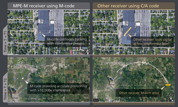
    We designed our GAJT product line to be receiver-agnostic and compatible with legacy and modern GNSS receivers. This flexibility results in GAJT being ideal for civil and military applications, including SAASM and M-code systems.

    How does your GNSS Resilience and Integrity Technology (GRIT, launched in 2020 November) relate to your GAJT antennas?

    GRIT is a firmware suite for our OEM7 receivers that expands their situational awareness and interference mitigation tools. GRIT includes our Interference Toolkit (ITK) along with spoofing detection to identify when your GNSS signal may be under threat. It also empowers the user to develop interference location algorithms through time-tagged snapshots of data samples to characterize the RF environment around your operations. GRIT, alongside GAJT, forms the foundation of our APNT strategy in providing accurate and always-available PNT.

    Do you have any recent contracts with the U.S. Department of Defense or the militaries of other NATO countries to supply GAJT antennas?

    Our GAJT product portfolio has been sold in large quantities to military and civil organizations for many years, successfully proving itself in the field. In 2020, we achieved a milestone of more than several thousand units shipped worldwide, making it one of Hexagon | NovAtel’s more successful years.

  • Tiny clock meets big challenges

    Tiny clock meets big challenges

    chip-scale atomic clocks can supplement GNSS receivers to provide accurate and reliable time in GNSS-challenged environments. Photo: Microchip Technology
    Chip-scale atomic clocks can supplement GNSS receivers to provide accurate and reliable time in GNSS-challenged environments. Photo: Microchip Technology

    Accurate and reliable time is just as important as accurate and reliable location for a wide range of military and civilian applications — and GNSS receivers cannot provide either one when they are jammed. For timing, one solution is to supplement GNSS receivers with a miniature atomic clock. We asked Microchip Technology a few questions about their chip-scale atomic clock (CSAC) and Stewart Hampton, the company’s senior product line manager, responded.

    How long was your SA65 CSAC in development before you announced it in August 2021? Typically, how often do you launch a new CSAC?

    CSAC development started in 2001 under a contract from DARPA with Draper and Sandia laboratories. CSAC was first introduced to the commercial marketplace in 2011, and in 2016 we released an improved product design with an operating temperature range of –10 C° to +70 C°. Last year we released our CSAC SA65 with a wider operating temperature range, faster warm-up and improved frequency stability aimed at the defense and industrial marketplace. So, it has been about five years between major CSAC releases, but that may not be indicative of future products because we have also introduced specialized CSAC versions, such as the Low Noise CSAC (LNCSAC) in 2014 and the only commercially available radiation-tolerant CSAC (Space CSAC) in 2018.

    What is the CSAC SA65’s drift rate?

    Its typical drift rate is specified at <9 × 10⁻¹⁰ per month. Another key specification, particularly for many portable military applications, is total sensitivity of frequency to temperature (tempco) over a specified range. For the CSAC SA65, that specification is ±3 × 10⁻¹⁰ over the entire operating temperature range of –40 C° to +80 C °.

    What are a few specific military use cases?

    CSAC is designed into multiple military programs and used in a wide variety of military applications, particularly in GNSS-denied environments — including assured positioning, navigation and timing (APNT) modules, underwater unmanned and autonomous vehicles, software-defined radios, man-portable transceiver-based military communications, vehicle management computers, airborne reconnaissance/UAVs and GNSS-disciplined oscillators. It is also used in command, control, communications, computers, cyber, intelligence, surveillance and reconnaissance (C5ISR). The space CSAC variant is commonly used on low-Earth-orbit space defense payloads supporting such applications as low-latency communications networks, RF geolocation (geointelligence, or GEOINT), optical time transfer, alternative PNT satellites and Earth observation.

  • Realism in chamber-based CRPA testing

    Realism in chamber-based CRPA testing

    Spirent Federal Systems, a PNT simulation company, offers its government customers and contractors a unique solution for anechoic-chamber-based CRPA testing: a patented “zoned chamber” approach using multi-output, multi-constellation GNSS signal simulators to emulate the movement of satellites in orbit.

    To address the limits of a standard anechoic chamber, Spirent has created independent zones configured to represent the real-world sky view, using genuine constellations and improved satellite azimuth and elevation arrival angles. Test scenarios can be multi-constellation and multi-frequency with customizable time, date and duration — now lasting hours instead of minutes.

    Because scenarios are valid for longer time periods without sacrificing realism, the zoned chamber is effective for validating all aspects of the CRPA system including beamforming, null steering and space-frequency adaptive processing/space-time adaptive processing (SFAP/STAP). CRPA systems with inertial sensors can be tested with static and dynamic scenarios using a positioner within the chamber.

    Additionally, to account for multipath and signal obscuration, Spirent has integrated a 3D environment modeling tool which generates all the variables of a multipath-rich environment in real time, including ground reflection. Interference sources such as jammers and spoofers can be added anywhere in the chamber and concurrently simulated with the GNSS signals. Authorized users can also test classified RF signals such as MNSA M-code and Y-code.

    “Spirent Federal’s goal is to get new technologies to U.S. warfighters at a speed that outpaces near-peer threats,” said Jeff Martin, vice president of Sales. “The realism of our patented zoned chamber allows advanced CRPA systems to be deployed faster with confidence they will perform in GPS-contested environments.”

    Illustration of a simulated test environment incorporating GNSS, multipath and jamming in a Spirent zoned chamber. (Image: Spirent Federal)
    Illustration of a simulated test environment incorporating GNSS, multipath and jamming in a Spirent zoned chamber. (Image: Spirent Federal)
  • The transition to M-code begins

    The transition to M-code begins

    BAE Systems has produced more than one and a half million military GPS receivers. The company is transitioning receiver designs to use the modernized military code (M-code) signal for added resiliency in RF-challenged environments. We asked Luke Bishop, director and product line engineering lead for the company’s Navigation & Sensor Systems, a few questions.

    BAE Systems’ MPE-M provide the benefit of M-Code operation in a challenged RF environment. Image: BAE Systems
    BAE Systems’ MPE-M provides the benefit of M-Code operation in a challenged RF environment. Image: BAE Systems

    Why transition to M-code?

    There are three key reasons for users to transition to M-code as supported by Military GPS User Equipment (MGUE). First, MGUE provide U.S. forces and our allies with enhanced PNT capabilities while improving resistance to threats, such as accidental and intentional jamming. Compared to the current P(Y)-code signal specs, M-code signals are stronger. Second, MGUE provides improved resistance to spoofing. Third, MGUE is field programmable, enabling updates to accommodate future enhancements to the GPS enterprise, such as regional military protection (RMP).

    Which user equipment is transitioning to M-code?

    Successful MGUE Inc 1 prototype development is being leveraged into a full portfolio of weapons, ground and aviation/maritime M-code GPS receivers. Our first production M-code receiver, MPE-M, achieved production deliveries in CY2021, with more than 1,000 delivered. Additional M-code GPS form factors are under development.

    We are also underway with the Foreign Military Sales (FMS) M-code program with MPE-M.

    How is the transition to M-code proceeding?

    As indicated by the January 2021 GAO report (GAO-21-145), M-code-capable user equipment is in the initial stages of Department of Defense (DOD) fielding for select weapon systems. Also noted by the GAO report, the DOD has conducted bulk purchases of the Increment 1 ASICs [application-specific integrated circuits] to ensure that “sufficient supplies of [them] are on hand for future integration into M-code card …based on estimated need through 2028.” We are at the beginning of M-code (MGUE). Time and the market will tell what ultimately happens.

    Which of your receivers operate with an anti-jam (AJ) antenna?

    BAE Systems’ receivers support both stand-alone AJ and integrated AJ. Receivers with integrated AJ include the NavFire-M, NavStorm-M and SABR-M receivers supporting high-dynamic weapons applications. Receivers directly supporting external AJ via a digital beamforming interface include the MPE-M and AMR. Our external AJ DIGAR offering provides exceptional performance for many stakeholders.

    Do you use advanced signal simulation equipment?

    We integrate Spirent Federal and other signal simulators in both our test and development environments, where modeled RF signals are coordinated with other sensor measurements and host vehicle messages for high-fidelity hardware-in-the-loop test cases. Our engineers create hundreds of test cases and scripted test procedures to exercise our products under all required conditions. These simulations allow us to run thousands of trials to qualify and validate performance of our products in extreme scenarios.

    Photo:
    BAE Systems’ hardware-in-the-loop simulation environments build upon Spirent Federal signal generators to test products under extreme dynamic and threat environments. (Photo: Spirent Federal)
  • New APNT in an old box

    New APNT in an old box

    Leonardo DRS’ A-PNT Converged Computer – Embedded & Scalable (AC²ES) adds capabilities to its widely used DDUx. Photo: Leonardo DRS
    Leonardo DRS’ A-PNT Converged Computer – Embedded & Scalable (AC²ES) adds capabilities to its widely used DDUx. Photo: Leonardo DRS

    To help counter attacks that degrade GNSS capability on combat vehicles, Leonardo DRS developed a modified data-distribution unit computer, the DDUx II, with an embedded assured positioning, navigation and timing (APNT) capability the company calls Assured Positioning, Navigation and Timing Converged Computer Embedded & Scalable (AC²ES). It augments standard military GPS PNT sources with technologies such as anti-jam, anti-spoof, M-code receivers, additional RF sources, vehicle infrared (IR) sensor vision navigation, wheel rotation and inertial measurement units (IMUs). It also offers a choice of multiple timing holdup modules that increase accuracy proportionately with cost.

    The DDUx II and military variants, fielded by the U.S. Army and Marine Corps, allow for integration of APNT functionality with the Battle Management System (BMS). It can provide APNT distribution to all other devices needing PNT within the vehicle without adding to its size, weight and power (SWAP).

    Following a five-year development program, Leonardo DRS launched the AC²ES in September 2021 as a commercial option while continuing discussions with the U.S. Army and Marine Corps, which have not yet adopted it. “We have tested it,” said Mike Stucki, business development manager for the company’s land electronics division. “We have gone to Army jamming and testing events. We have performance and results. However, it has not been officially tested under the Army or Marines programs, with which we are moving forward this year.”

    Leonardo DRS wants to offer the armed services the additional components they need to achieve APNT “and not require them to buy anything they don’t need or want,” Stucki said. Those additional components include multiple GNSS receivers for timing and a low-end internal IMU to provide continuous navigation in case GNSS is disrupted. All these components fit directly into the existing DRS hardware. Under the Mounted Family of Computer Systems (MFoCS) program alone, the Army has fielded more than 100,000 DDUx units. Some vehicles already have high-end INS, wheel encoders, and other sensors, and MFoCS can ingest their data.

    Navigating with Infrared

    For vision navigation, Leonardo DRS uses software developed by its partner Leidos that ingests data from existing hardware on the vehicles, many of which already have IR cameras. In a GNSS-denied environment, this enables the system to navigate by matching what the IR camera sees to an imagery database. Leidos’ software is based on work it began in 2011 with the DARPA All-Source Positioning and Navigation (ASPN) program.

    “Leidos developed algorithms that use these other sensor inputs in the sensor-fusion engine to provide more accurate absolute positioning in a completely RF-denied environment,” said Kevin Betts, PNT director for Leidos. “We take the live images from the vehicle’s existing IR camera and match them to a satellite-derived model of the environment. When the images match, we have an absolute position update that we can provide to the navigation filter.”

    MFoCS “is the heart that runs the Blue Force tracker system that the soldiers use,” said Bart Blanchard, director of advanced programs at Leonardo DRS. “We’ve added the APNT components inside that box. They’re leveraging the hardware that they already own. It’s a very cost-effective solution.”

  • Downed Russian jets found with GPS receivers taped inside

    Downed Russian jets found with GPS receivers taped inside

    Russian fighter jets in better times. (Photo: Aterrassi/iStock/Getty Images Plus/Getty Images
    Russian fighter jets in better times. (Photo: Aterrassi/iStock/Getty Images Plus/Getty Images

    Russian jets using GPS receivers, while ground vehicles use paper maps

    GPS receivers have been found taped to the dashboards of Russian jets downed in Ukraine, according to a report from Express. The Express received the information from Ben Wallace, United Kingdom defense secretary, who mentioned it in a speech at the National Army Museum.

    The GPS receivers were found taped to the dashboards of Russian SU-34s because of “the poor quality of their own systems,” he said. It is unclear whether he was referring to the Russian GLONASS satellite navigation system or the navigation systems aboard the SU-34 jets, but most likely the latter. Lack of maintenance and modernization of Russian military equipment has been obvious since the beginning of Russia’s invasion of Ukraine.

    As for navigation on the ground, many vehicles were found with paper maps from the 1980s, Wallace said.

    Russian ground vehicles also lack situational awareness and digital battle management, he said, while the large amount of footage from Ukrainian drones points to a lack of wider air defense, including counter-UAV systems.

    In a different news story from the war, Ukraine may be receiving Raytheon-built GPS-guided artillery rounds.

  • Tekever launches AR3 hot-swappable VTOL and integrated SAR

    Tekever launches AR3 hot-swappable VTOL and integrated SAR

    The AR3 maritime surveillance drone, usually launched horizontally, can be launched vertically with attachable propellers. (Photo Tekever)
    The AR3 maritime surveillance drone, usually launched horizontally, can be launched vertically with attachable propellers. (Photo Tekever)

    Tekever, a European maritime surveillance provider, has unveiled a new version of its AR3 unmanned aerial system (UAS). The AR3 now has a “hot-swappable” vertical-takeoff-and-landing (VTOL) capability, able to switch from horizontal launch to vertical. It also now has integrated synthetic aperture radar (SAR).

    Tekever made the announcement at AUVSI Xponential 2022 in Orlando, Florida. The company specializes in maritime surveillance services that deliver actionable real-time intelligence. The AR3 is a shipborne UAS designed to support multiple types of maritime and land-based missions up to 16 hours. With the upgrade, the AR3 becomes more operationally flexible, the company said.

    AR3 Hot-Swappable VTOL with SAR integrated from Tekever on Vimeo.

    “Users no longer have to choose between having pure fixed-wing assets for longer endurance missions, or fixed-wing VTOL assets for more challenging deployment conditions,” explained Ricardo Mendes, Tekever CEO. “The AR3 combines both capabilities and provides users with the ability to decide the configuration just moments before takeoff.”

    The newly added SAR provides the AR3 with a vastly greater operational range, and the ability to effectively detect, recognize and identify targets under any weather condition. Covering more than 20,000 square nautical miles per mission, the new AR3 is the suitable for wide-area surveillance missions.

    “Our SAR, which we named Gamasar in honor of the Portuguese navigator Vasco da Gama, is designed and built by Tekever specifically to provide our customers with capabilities that are typically only available through much larger systems,” Mendes said. “With an extremely reduced logistics footprint, the unprecedented VTOL flexibility and the unique capabilities provided by Gamasar, the new AR3 is a game changer that provides our customers with tremendous value and cost effectiveness.”

  • DroneShield releases major firmware release for its C-UAS devices

    DroneShield releases major firmware release for its C-UAS devices

    DroneShield RfPatrol body-worn C-UAS device with enrolled firmware upgrades. (Photo: DroneShield)
    DroneShield RfPatrol body-worn C-UAS device with enrolled firmware upgrades. (Photo: DroneShield)

    DroneShield has begun releasing a software update across its counter-unmanned-aerial-system (C-UAS) devices, including portable, vehicle-based and fixed-site devices. The devices are used by the military, the intelligence community, U.S. Homeland Security, law enforcement, critical infrastructure and others.

    The updates will be rolling out across DroneShield devices globally in the coming week, with heightened urgency given the widespread use of drones in Ukrainian and Middle Eastern conflicts. The technology upgrade is validated by deployments with the U.S. Air Force and Australian Army.

    Enrolled devices receive quarterly firmware updates of the proprietary DroneShield RFAI artificial intelligence engine. Some of these updates are major enhancements, such as this 2Q22 release.

    Major upgrades include:

    • Site Install Wizard. The new Spectrum Viewer mode, in which C-UAS detection devices scan the deployment area for optimal sensor placement
    • Machine Learning in the Loop. This option enhances the RFAI engine from the data received by the user.

    Both features were added in response to end-user requirements.

  • Orbital Insight partners with Satellogic on satellite imagery and video

    Orbital Insight partners with Satellogic on satellite imagery and video

    A sample image from Orbital Insights showing classes of military aircraft at a base. (Image: Orbital Insights)
    A sample image from Orbital Insights showing classes of military aircraft at a base. (Image: Orbital Insights)

    Orbital Insight will integrate Satellogic’s high-resolution multispectral imagery, hyperspectral imagery, and full-motion video into its GEOINT platform

    Geospatial intelligence company Orbital Insight has partnered with Satellogic, a leader in sub-meter resolution satellite imagery collection. The partnership will integrate Satellogic’s high-frequency, high-resolution collections of satellite imagery and full-motion video into Orbital Insight’s platform and offer customers better access to high-quality data, improve the revisit rate, and reduce the cost of running analytics.

    Satellogic designs, manufactures and operates its own constellation of Earth observation satellites. It  has 22 operational satellites in low Earth orbit with plans to launch up to 12 additional satellites by the end of the year. The company aims to expand its constellation to more than 200 satellites by 2025 for daily global coverage of the entire surface of the Earth.

    Orbital Insight’s flagship GO platform combines information from the world’s sensors to analyze economic, societal and environmental trends at scale and support activity-based intelligence. Commercial businesses and government agencies use the self-service platform to synthesize answers to critical questions about what’s happening on and to Earth.

    Satellogic will provide high-resolution Earth observation data at vastly superior unit economics. This will allow Orbital Insight customers to increase the number of daily revisits on points of interest, see a more granular picture and get deep insights that were not possible before.

    “Advanced geospatial analytics require access to high-resolution, high-frequency satellite imagery and simple tasking,” said Kevin O’Brien, CEO, Orbital Insight. “Satellogic is disrupting the industry with a cost-effective, vertically integrated business model. This approach aligns well with our philosophy of making geospatial intelligence efficient, intuitive, and simple so that our customers can get timely insights, make critical decisions, and respond faster.”

    “Our mission is to enable greater access to critical Earth observation data. Working with Orbital Insight extends our reach, making our data available to more customers across diverse fields who need to know how the world around them is changing,” said Emiliano Kargieman, CEO and co-founder of Satellogic.

  • US security package for Ukraine includes Phoenix Ghost drones

    US security package for Ukraine includes Phoenix Ghost drones

    On April 21, the Pentagon announced an $800 million security package for Ukraine defense, including 121 tactical unmanned aerial systems (UAS) dubbed Phoenix Ghost drones.

    According to the Pentagon, the drones were rapidly developed by the Air Force specifically to meet Ukraine’s requirements. The Ghost drones are manufactured by Aevex Aerospace and have similar capabilities to the single-use “kamikaze” Switchblade UAS from AeroVironment.

    The U.S. is also sending at least 300 more Switchblade drones, according to CNBC, though which model has not been revealed. The 300 variant is designed to strike small targets. It can fit in a rucksack, weighs a little more than 5 pounds and has a range of 10 miles. The 600 version of the weapon is designed to destroy tanks and other armored vehicles. It weighs slightly more than 120 pounds and has a range of more than 40 miles.


    AeroVironment is also donating more than 100 Quantix Recon UAS and operational training services to Ukraine’s Ministry of Defence and territorial forces. Using the actionable intelligence gathered by the Quantix Recon, operators can conduct quick mission planning and verification to help keep Ukrainian ground forces out of harm’s way. Delivery of the Quantix Recon UAS is independent of other AeroVironment tactical missile systems and UAS provided to Ukraine by the United States.

    The Phoenix Ghost drone is similar to the single-use Switchblade drone from AeroVironment. (Photo: AeroVironment)
    The Phoenix Ghost drone is similar to the single-use Switchblade drone from AeroVironment. (Photo: AeroVironment)
  • Iris Automation launches ground-based surveillance system for UAVs

    Iris Automation launches ground-based surveillance system for UAVs

    Photo: Iris Automation
    Photo: Iris Automation

    Iris Automation has announced the commercial availability of Casia G, a ground-based version of its detect-and-avoid surveillance solution.

    Using the same patented artificial intelligence (AI) and computer-vision technology as Iris Automation’s onboard solutions, Casia G provides 360° optical detection with alerts. It enables operators to avoid both cooperative and non-cooperative aircraft for safe beyond-visual-line-of-sight (BVLOS) flight.

    Casia G creates a perimeter of monitored airspace for UAVs to perform work safely, without additional payload. It’s suitable for operations in fixed or temporary locations, supporting drone-in-the-box operations and augmenting or replacing human visual observers. BVLOS flight for unmanned systems has been challenging due to right of way concerns, specifically the inability for unmanned aircraft to successfully see and avoid other aircraft.

    “A human has sufficient visual acuity to see airborne traffic only within a +/-5 degree field of view around our focal point. We have to scan the sky, and are frankly not very good at it,” said Jon Damush, CEO, Iris Automation. “Casia G sees the entire sky, with uniform probability and resolution, 10 times per second — without distractions or breaks. This  solution for airspace awareness covers a large majority of small UAS use cases, but at a price point that is economically viable and without complex integration.”

    Casia G can be expanded by adding additional units in a mesh to create a network of detection nodes for large-area air risk mitigation. The system then provides a single feed of cooperative and non-cooperative air traffic, available to an operator’s traffic management system. This provides a path to approvals for both larger area and one-to-many operations by enabling a holistic view of the airspace, the company said.

    Casia G has already obtained a BVLOS waiver on behalf of the City of Reno. Iris Automation is in the process of proving additional deployment patterns and concepts of operation with the FAA.

  • China hack breaches satellite security, Symantec reports

    China hack breaches satellite security, Symantec reports

    Photo: EvgeniyShkolenko/iStock/Getty Images Plus/Getty Images
    Photo: EvgeniyShkolenko/iStock/Getty Images Plus/Getty Images

    Hackers in China managed to gain entry into satellite operators, defense contractors and telecommunications companies in the United States and southeast Asia, reports Reuters.

    Reuters spoke with security researchers at Symantec Corp. ahead of public release of a security report. The hackers have been removed from infected systems.

    The hackers breached computers that controlled the satellites, including access to orbital systems, Symantec said. GNSS, communication and other data transmissions rely on specifically situated satellites.

    Symantec said it has already shared technical information about the hack with the U.S. Federal Bureau of Investigation and Department of Homeland Security.