The 62nd meeting of the U.S. government’s Civil GPS Service Interface Committee (CGSIC) will be held Sept. 19–20 in the Hyatt Regency Denver at the Colorado Convention Center, before the annual ION GNSS+ conference.
It will be hosted by the U.S. Department of Transportation (DOT) and the U.S. Coast Guard Navigation Center (NAVCEN). DOT serves as the civil lead for GPS and chairs the CGSIC in this capacity. NAVCEN is assigned duties as Deputy Chair and Executive Secretariat for the CGSIC.
On Sept. 19, the CGSIC subcommittees for Timing, International Information, and Survey, Mapping, and Geosciences will meet. A summary of these meetings will be presented to the CGSIC Plenary Session on Sept. 20.
Cordell DeLaPena, Program Executive Officer for Military Communications and PNT Space Systems Command
Keynote speaker for the plenary session is Cordell DeLaPena, program executive officer for Military Communications and Positioning, Navigation, and Timing, Space Systems Command, Los Angeles Air Force Base.
The agendas for the CGSIC subcommittee and plenary sessions will include presentations on the operational status and modernization of the GPS constellation of satellites, U.S. space-based positioning, navigation and timing (PNT) policy, GPS augmentation systems, and information related to U.S. engagement with other international GNSS as well as a variety of interesting applications of the use of GPS.
Several new briefings are part of the plenary session this year, including a presentation from NASA on the role of GPS in support of the next lunar mission. Also, the Department of Homeland Security will provide an update on the activities of the Office of Infrastructure Protection, Positioning, Navigation, and Timing Program Management Office.
This year’s meeting will be live-streamed over the internet. For those who are unable to travel, the meetings can be accessed with the links below.
The agenda for the meeting is available; all CGSIC presentations will be available there for viewing online shortly after the meeting ends. As a reminder, all CGSIC meetings are free and open to the public.
DroneShield’s RfPatrol MKII body-worn system antennas. (Photo: DroneShield)
DroneShield has received and delivered upon a follow-on order by a U.S. government agency for the company’s portable and handheld counter-UAS (C-UAS) solutions.
DroneShield is the maker of the counter-drone or anti-drone systems including RfPatrol and DroneGun MkIII. It has received contracts from the U.S. departments of Defense and Homeland Security, as well as other federal and state law enforcement agencies.
“We’re grateful for the continued trust that this organization has placed in us to help address a unique set of operational challenges. Our customer relationships are what fuel our commitment to push the boundaries of what’s possible in the counter unmanned space,” said Tom Branstetter, director of business development, DroneShield. “Every teammate at DroneShield understands the significance of the problems we’re solving for our end-users and it’s something we’re proud to support.”
DroneShield also recently announced deployments of its solutions for high-profile events including the World Economic Forum (WEF) in Davos, Switzerland, and IRONMAN Texas 2022.
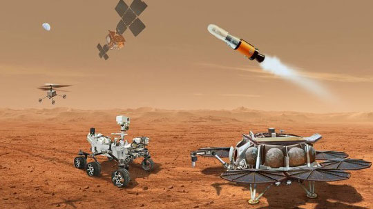
NASA and the European Space Agency (ESA) have been cooking up a way to get some of Mars back to Earth, so that samples can be analyzed in detail — just like the rocks the astronauts brought back during the Apollo missions, which gave us a deeper understanding of our Moon.
The Perseverance rover already on Mars has been seeking promising areas to investigate that might provide evidence of ancient past life, with the help of the Ingenuity helicopter drone. Recently, the two worked together to drive the rover to an old river delta, expected to be a prime location where such samples could be found.
The rover has been drilling and saving rock and dirt samples in onboard storage tubes. The difficulty is that getting them back to Earth requires another major undertaking.
Returning the Samples
Termed the “Sample Return Mission,” the two space agencies have been discussing for months how best to bring the samples back, and have now refined an approach. Given that Perseverance has been so good at the job it was given, the NASA/ESA team has decided that the rover should be used for the return mission in 2030 when things would be in operation on Mars. (We’re not sure if the warranty sticker on Perseverance will still be valid in 2030, but if past performance is an indication, all the rovers have significantly outlived their initial design lives.)
Its partner Ingenuity has graduated from proving it can fly in the thin Martian air to actually scouting routes for the large rover. Because Ingenuity has proven reliable and capable of traveling significant distances, NASA and ESA have decided that two new helicopter drones will become part of the return mission. They will be based on the successful Ingenuity design, but will be fitted with wheels, one on each of the four landing legs, to enable movement on the ground.
They will also be fitted with a device which is capable of picking up and carrying a sample tube. Since the prototype drone helicopter was designed to be as light as possible, this infers a substantial increase in lift capacity will be required. The original mission included a sample-collection rover, but this task will now be assigned to Perseverance, with the two sample-carrying helicopters acting as backup, if needed.
An earlier concept had the rover dropping sample canisters behind it as it progressed around the surface for subsequent pick up. This concept appears to have been shelved for the moment. Keeping the canisters onboard the rover throughout perhaps simplifies transfer to the return lander.
This NASA return sample concept illustration includes wheeled helicopters. (Image: NASA/JPL-Caltech)
The Mars Ascent Vehicle would then carry the samples into orbit, to a waiting Earth Return Obiter, where the samples would be transferred to a return system for onward transit and atmospheric re-entry to Earth. Some of these details are a little sketchy, but there sure are a lot of moving (autonomous, robotic?) parts. This, of course, means a lot of opportunities for something to go wrong. No doubt continuing refinement of the mission will reduce the risks. The Jet Propulsion Lab (JPL) and AeroVironment designed and built Ingenuity — they may face some challenges developing the successor helicopter drones.
Meanwhile, Here on Earth…
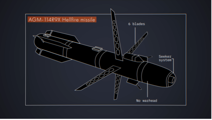
Drones led the news Aug. 1, when President Biden announced the killing of Ayman al-Zawahiri in Kabul, Afghanistan. Al-Zawahiri topped the U.S. 9/11 wanted list, and his removal was all about the offensive use of drones. Presumably fired from a General Atomics Reaper variant drone at quite some altitude, two Hellfire AGM-114R9X “knife bomb”missiles took out al-Zawahiri as he stood alone on the balcony of a home in Kabul.
This means that video/infrared from high altitude was sufficiently clear to determine that the man was alone on the balcony, presumably confirming information on the ground that his family was elsewhere. So long-distance, high-level authorization was then granted to fire on him in a foreign country now run by the Taliban.
Suspected damage at the al-Zawahiri house in Kabul. (Photo: Secunder Kermani/BBC News)
To minimize inadvertent casualties, the Hellfire R9X missile was used, which lacks explosive armaments. The weapon is a nasty piece of work, weighing ~100 lb with an inert payload, and fitted with six long knives that deploy before impact. This missile has previously been used in perhaps 11 other instances to take out terrorist individuals and minimize collateral damage.
Bladed R9X missile lacks a warhead (Image: Newsy/Bellingcat)
This is another instance of how the U.S. use of military drones has become less devastating, but is still very deadly to the specific target.
To Sum Up
We’ve taken a quick glimpse at how NASA and ESA are planning more drones for the surface of Mars, and a much more aggressive use of drones here on Earth.
USSF Lt Col Robert Wray takes command of 2SOPS. (Photo: USSF/Dennis Rogers)
The 2nd Space Operations Squadron (2 SOPS), which oversees the GPS constellation, now has a new leader. Outgoing U.S. Space Force (USSF) Lt. Col. Michael Schriever relinquished command of the unit to USSF Lt. Col. Robert Wray.
The squadron conducted a change of command ceremony at Schriever Space Force Base, Colorado, on July 6, officiated by Space Delta 8 Commander Col. Matthew Holston.
As the new commander, Wray assumes the responsibility of overseeing the daily operations of a unit whose mission is to operate the GPS constellation, which provides global navigation, time transfer, and nuclear detonation detection.
Col. Matthew Holston honors Lt. Col. Michael Schriver for his 2SOPS service. (Photo: USSF/Dennis Rogers)
Focus Telecom has introduced a new timing product for defense and mission-critical applications, the Time-Loader.
The Time-Loader can be deployed in environments where GNSS signals are denied or disrupted, to support any ground, naval and airborne system that needs real time of day (TOD) and 1PPS external synchronization aligned to UTC or GNSS.
In this emerging era of rapid tactical deployment of defense systems, communications intelligence, missile defense systems, radar/electro-optical sensors and UAS batteries in the field are often in GNSS-denied or jammed environments. This situation creates challenges for access to real time and accurate time of day.
To solve this problem, the Time-Loader generates a GPS L1 C/A code RF output as if the signal were coming from a live-sky GPS antenna. It provides full-constellation GPS output and is compatible with external GNSS receivers. It encodes times with nanosecond accuracy for GPS timing receivers.
The Time-Loader’s GPS-disciplined oscillator (GPSDO) is the Microsemi MAC-SA53/55, which provides excellent UTC accuracy with outstanding hold-over rubidium clock performance.
The Time-Loader is the size of a suitcase, hand-carried and easily deployed. It activates quickly from a cold start or when sensors are deployed for the first time.
Included in the Time-Loader is a self-contained, miniature GPS simulator that provides real-time extremely accurate signals. The 18-channel full-constellation simulator stores location/time/date data in internal memory and stores complex vector data to simulate dynamic scenarios. The simulator also can be used to transcode NMEA or SCPI position/velocity/time (PVT) data into GPS RF signals.
A demonstration airspace management system is playing a role during the military exercise Rim of the Pacific (RIMPAC) 2022, taking place in Hawaii and Southern California.
FlightHorizon COMMANDER, provided by Vigilant Aerospace to the U.S. Air Force, is an airspace management and detect-and-avoid system based on two licensed NASA patents. The system can be used on the ground or onboard aircraft and is designed to help keep unmanned aircraft systems (UAS or drones) safe and collision free.
For the first time, U.S. Air Force MQ-9 UAS — also known as a Reaper — is taking part in a RIMPAC exercise. RIMPAC is the world’s largest international maritime exercise, involving more than 40 ships, 30 UAS and 150 aircraft from 27 partner nations.
RIMPAC 2022 is the 28th exercise in the series that began in 1971. The 2022 exercise takes place from late June to early August.
The FlightHorizon COMMANDER demonstration system (non-U.S. Air Force) tracks air traffic in Hawaii in 2022. (Photo: Vigilant Aerospace)
FlightHorizon COMMANDER includes a 3D moving map display for air traffic situational awareness, air navigation charts, weather data, special features for the tracking and safety of uncrewed aircraft systems (UAS) and automatic detect-and-avoid functions.
The airspace management system correlates and displays air traffic and other data from a wide variety of sources including ground-based and airborne sensors, civilian air traffic data, military data and proprietary data sources. The dual-use technology provides automatic traffic warnings and deconfliction as a built-in function.
The product is based on two licensed NASA patents and has been used in ongoing NASA supersonic projects, in FAA detect-and-avoid projects, and in civilian UAS projects around flight corridors and drone ports.
“RIMPAC 2022 marks the first appearance of the MQ-9A Reaper, a remotely piloted aircraft, and its presence brought in military teams from California, New Mexico and Nevada,” the Air Force stated. “With personnel from both the active-duty element, Reserves and Air National Guard, the collective group ensures that it is fully operational. All the while, everyone learns new techniques that it will take to improve their day-to-day operations upon returning home.”
“Vigilant Aerospace is thrilled to support this large-scale exercise,” said Kraettli L. Epperson, CEO of Vigilant Aerospace. “Support of this exercise is an especially useful demonstration of the multi-sensor and multi-data source capabilities of FlightHorizon and the ability to track hundreds of targets simultaneously.”
Vigilant Aerospace holds a U.S. Department of Defense IDIQ to support military adoption of the system for UAS and airspace safety.
Galileo Second Generation Batch#1B satellites. (Image: ESA).
Technology multinational GMV has been awarded the NAVGUARD project by the European Commission.
NAVGUARD (Advanced Galileo PRS Resilience for EU Defence) will develop ground and space systems to detect illegal activities on GNSS frequencies and geolocate their sources. It also will build an information-management subsystem together with a user interface to provide a situational awareness picture.
The Galileo Public Regulated Service (PRS) is an encrypted navigation service for governmental authorized users and sensitive applications that require high continuity.
According to the EU Agency for the Space Programme (EUSPA), the PRS signal will ensure better continuity of service to authorized users when access to other navigation services may be degraded (resilience). In cases of malicious interference, PRS increases the likelihood of the continuous availability of the signal-in-space (robustness).
NAVGUARD is among various European Defence Fund (EDF) projects designed to sharpen the competitiveness of the European Union defense industry and strengthen the EU’s strategic autonomy. Besides navigation, the projects contracted to GMV will focus on developing missile defense system capabilities, systems for dismounted soldiers, avionics, command and control and cyber defense.
A division of the U.S. Army Futures Command is conducting stratospheric experimentation using the Zephyr ultra-long endurance stratospheric unmanned aerial system (UAS). The tests are being carried out at Yuma Proving Ground in Arizona by he Assured Positioning, Navigation and Timing/Space (APNT/Space) Cross-Functional Team (CFT), which is based in Huntsville, Alabama.
The first flight of 2022, launched June 15, demonstrated Zephyr’s energy storage capacity, battery longevity, solar panel efficiency and station-keeping abilities that will further the army’s goal to implement ultra-long endurance stratospheric UAS capabilities.
During the flight, the Zephyr accomplished a number of firsts, including
first flight into international airspace
first flight over water
longest continuous flight utilizing satellite communication controls
the farthest demonstration from its launch point while carrying a commercial, off-the-shelf payload
breaking the world record for longest duration UAS flight (26 days) set by the same aircraft in 2018. This flight has completed 36 days and is still flying over Yuma Proving Ground.
“Ultra-long endurance unmanned platforms have the potential to provide significant military capabilities and enhanced confidence as part of the Army’s diversified multi-layered architecture,” said Michael Monteleone, director of the APNT/Space CFT. “We have seen incredible progress in high-altitude platforms in recent years. This experimentation allows us to build on that knowledge by demonstrating multiple payload types, fully exploring the military utility of stratospheric operations, and modernizing areas of deep sensing, long-range targeting and resilient communications.”
Zephyr is prepared for a flight test. (Photo: Airbus)
Upcoming Second Launch. A second Zephyr flight will launch in the coming weeks and travel over the Pacific Ocean. The flight will demonstrate a prototype payload, developed by the Army Futures Command, over multiple combatant commands, and continue to inform high-altitude requirements.
The Airbus-developed Zephyr is the first high-altitude UAS of its kind, providing a persistent and adaptable longevity in the stratosphere. The experiments are performed with cooperation of the Intelligence, Surveillance and Reconnaissance (ISR) Task Force, U.S. Army Program Executive Office – Aviation, and multiple combatant commands under an Other Transaction Authority (OTA), with T2S Solutions LLC as the integrator.
The APNT/Space CFT is responsible for accelerating the delivery of advanced APNT, tactical space and navigation warfare capabilities to the soldier. Working with a core team of experts, the CFT informs technology and system requirements through continuous experimentation and prototyping, technology integration and soldier feedback. Through this process, the APNT/Space CFT supports the Army Futures Command in delivering next-generation weapons, vehicles and equipment at an accelerated rate, giving Army forces the ability to deploy, fight and win decisively against any adversary, anytime and anywhere.
This month, we have developments across the globe, with drones inspecting power distribution systems and nuclear waste disposal in the United Kingdom, counter UAS (C-UAS ) systems deployed in Greece, and news of cutbacks in the UAV industry affecting two major suppliers.
UK Turns to Drone Power
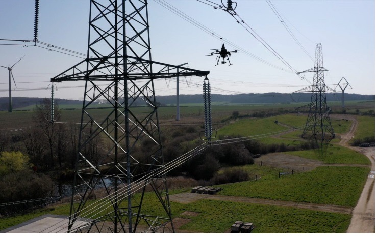
The UK has reduced coal power generation significantly since 2013 by increasing use of natural gas, nuclear power and renewable sources. Power is distributed throughout the UK by the National Grid Electricity Transmission (NGET) via 4,000 miles of overhead high-voltage lines carried on 21,900 steel pylons. With another 330 substations to also look after, the infrastructure for power distribution in UK always has required a huge maintenance effort. This picture is likely reflected in the power distribution networks of most countries around the world.
Helicopters have carried a large portion of the workload to enable inspection of cables and insulators, with additional necessary manual inspections taking significant effort to gain access and analyze data. Helicopter time is expensive, and manual inspection processes and data analysis are tedious and time consuming.
Drones are being used for power-line inspection — flown manually by onsite operators — by many organizations in several countries around the world, including by FPL in Florida. But the real reduction in time and effort comes from automating the whole process, and gathering data that provides the detail necessary to assure defects are detected and operational integrity is maintained. The automation of data analysis and generation of useful reports is another area which could yield major savings, and bring rapid focus to areas needing immediate corrective action.
A pylon inspection automation. (Photo: NGET)
Hence, a 12-month trial is being undertaken involving ultimate approval by the UK Civil Aviation Authority (CAA) for beyond-visual-line-of-sight (BVLOS) multiple drone operations. Artificial intelligent (AI) analysis tools are being developed to determine critical changes in collected visual, lidar and positioning inspection data that might herald deterioration in pylon or other infrastructure components.
During an initial test in Nottingham, an autonomous drone was dispatched with minimal instructions. It was able to find its inspection target and complete the programmed inspection in a few minutes. A manual inspection could take up to an hour for the same task. If things go well, it is not impossible to be able to project multiple drones operating with minimal human control, taking on huge swaths of pylons, cabling, insulators and other elements during regular inspections, saving a lot of time and money.
The trials so far have also included remote inspection of the Sellafield nuclear waste decommissioning site, rail infrastructure and a telecommunications network along with investigations towards transport of medical supplies.
Sellafield is where spent fuel ends up from the UK’s 31 nuclear power plants. Also, nuclear waste from reactors in neighboring European countries is reprocessed here. Nuclear waste is processed into 50-ton concrete blocks and spent fuel is “vitrified” into huge chunks of glass, which are encased in an outside metal jacket. Both processes minimize any emitted radiation and allow the contents to safely cool over long term. The staff uses robots inside the facility to remotely dismantle contaminated areas and load material into 55-gallon drums, which might be further processed by robot crushing machines. No one has any real idea how all this nuclear waste could be permanently disposed of, but it’s possible most will ultimately be buried in the ground.
This type of power might seem a “green” boon for humanity, but in a somewhat countrified area on the West Coast of England and in other similar sites around the world, nuclear waste disposal is costly and very, very long-term. The half-life of uranium is between 159,200 years and 4.5 billion years. Monitoring the waste could be a long-term task for drones, such as those now used to detect radiation inside the Fukushima nuclear plant. Certainly, there’s plenty of time to evolve improved drone detection capability for radiation monitoring.
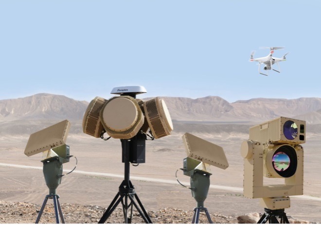
Greece Employs Counter-UAS against Turkish Incursions
On a defense-related note, apparently the long-running rivalry between Turkey and Greece is, unfortunately, continuing. It seems that Turkey has been repeatedly flying its Baykar-TB2 surveillance drone over Greek islands, perhaps to monitor the movements of Greek warships or island defense installations. And Greece is a little bit more than peeved.
Having established a defense-related relationship with Israel in 2021, Greece has brought Israeli drone defense systems to the Greek islands, installing a “veritable umbrella against enemy unmanned aerial vehicles.” The Israeli system has a number of moving parts: detect and identify; generate related alerts; a directional jamming system that can disable drones in flight (presumably by jamming GPS or the control link); and a laser that can lock onto a small target and, if manually fired, can apparently destroy an intruder drone.
DroneDome elements (Photo: Rafael Advanced Defense Systems)
Because of the directional, narrow beamwidth of the jammer, Rafael claims that the system can be activated within crowded civilian airspace without affecting the navigation of other users. Good news for Greece and their popular, attractive Greek island tourist destinations.
UAV Defense Contractors Struggle — with Each Other
Meanwhile, current economic uncertainty is apparently impacting at least a couple of UAV defense contractors: Boeing/Insitu and Orbital UAV. The two made news when Orbital, as an Australian public company (ASX symbol OEC), had to halt trading. The company was then able to reinstate trading largely because of news of cancellation of a development/production agreement with Insitu.
Apparently, Orbital has previously been delivering two-engine versions to Insitu and was contracted to develop and deliver a third derivative engine. However, Insitu had to scale back Orbital’s work in February, given its sales of the popular ScanEagle and other UAVs may have fallen off in recent months.
Orbital UAV Propulsion System (Photo: Orbital)
This has affected Orbital’s revenue forecast for the year. The company now expects to lose AUD $7 million for the year. It has subsequently prepared a claim under the supply agreement for Insitu’s Termination for Convenience of AUD $1.8 million in costs incurred in the development of the third engine program, which Insitu/Boeing disputes. There will obviously be some wrangling, but hopefully both parties will settle things amicably so as not to damage their ongoing relationship for supply of the existing two engine types.
ScanEagle UAV (Photo: U.S. Navy)
To sum up, for this month we have a trial in the UK which will hopefully lead to significant savings in effort and costs for ongoing power infrastructure inspections, along with some background on UK nuclear waste disposal. Greece is bristling and defending against unwanted Turkish drone overflight using Israeli C-UAS systems. Finally, there’s somewhat negative news for the Orbital UAV engine and Insitu ScanEagle relationship — apparently, not everything in the UAV garden is roses.
After a negotiation process that began in December 2021, Orolia officially joined Safran Electronics & Defense on July 8.
Orolia employs more than 435 people in Europe and North America and has revenues of about €100 million. Its solutions include atomic clocks, time servers, simulation and resilience equipment for GNSS signals, and emergency locator beacons for commercial aviation and military applications.
These products and solutions will complement Safran Electronics & Defense’s activities as it meets the challenges of positioning, navigation and timing (PNT) in contested and vulnerable environments, Safran said.
In most situations, GNSS receivers are the reference providers of time and position data. Still, they need to be secured by combining them with accurate, high-integrity autonomous time or inertial references.
Through this partnership with Orolia, Safran Electronics & Defense, will offer a comprehensive set of resilient PNT architectures and equipment to meet the challenges of integrity and robustness for the aviation, defense, space, transportation, new mobility and critical infrastructure markets.
“Orolia could not imagine a better fit than with Safran to secure its growth and leverage its PNT leadership positions,” said Jean-Yves Courtois, CEO of Orolia. “Thanks to the addition of best-in-class timing and inertial technologies, premier access to the largest defense and aerospace markets, and a proven track record in government program capture and execution, Safran and Orolia now have all the cards in hand to establish themselves as the resilient PNT leader.”
Martin Sion, CEO of Safran Electronics & Defense, said: “The acquisition of Orolia makes Safran one of the few companies with the full complement of PNT technologies, bringing together Orolia’s precise time referencing and Safran Electronics & Defense’s proven inertial navigation solutions. Our shared ambition is to become the world leader in resilient PNT for all conventional and strategic applications.”
Skydel 22.5 features advanced hardware-in-the-loop testing
Orolia has released Skydel 22.5, a significant software upgrade to its Skydel simulation product line that features advanced hardware-in-the-loop (HIL) testing solutions providing very low to zero effective latency.
The enhanced visualization tools can monitor internal latency through real-time curves showing when the data is generated and sent to the RF signal. Users can also review the transmission of HIL packets for optimizing the entire network’s latency, checking its stability (jitter), and that data is available and used at the right time in Skydel.
HIL testing is an essential step in the verification process of the model-based design (MBD) approach because it involves all the hardware and software that will be used operationally. HIL verification can test a standalone device-under-test (DUT) or, more generally, an entire complex system consisting of multiple DUTs in both open- and closed-loop architectures.
“The vast majority of problems encountered by engineers on HIL systems are related to poor control of the latency of the entire simulation chain, as they are insufficiently accessible, transparent and controlled on the competing systems,” said Pierre-Marie Le Veel, principal system architect and product manager for GNSS simulation. “Thanks to these tools, our high-end performance and well-known intuitive automation, Skydel dramatically reduces the implementation time of a HIL system (which can be very significant) and, therefore, the project’s overall cost.”
Photo: Orolia
In addition to these tools, Skydel implements modern extrapolation algorithms that achieve zero effective latency. These algorithms make it possible to keep position errors negligible, even for equipment with very high dynamics used in national defense applications such as missiles, rockets and guided shells.
“These advanced HIL algorithms and tools are available – and with the same performance – on our Wavefront simulation systems to test controlled reception pattern antenna (CRPA) systems,” Le Veel added.
Additional constellations, signal types and options such as real-time kinematic (RTK) and multi-instance are available along with dedicated bundled simulation starter packages for automotive.
The upgrade is available at no additional cost for existing users operating Skydel 22.5. Application notes, support documents and tutorials are available online.
Thales and Syrlinks have signed a multi-year contract with the French defence procurement agency (DGA) to develop a new generation of tiny, high-performance atomic clocks.
Code-named Chronos, these new quantum clocks will meet the requirements of numerous civil and military applications. With their very high stability (error of less than 1 second in tens of thousands of years), defence electronics equipment will be able to operate when a GNSS signal is unavailable, for example due to hostile jamming.
Working with the procurement agency, the partners will help safeguard France’s technological sovereignty in GNSS-denied positioning, guidance, navigation and encrypted military communications. In civil applications (5G network synchronization, transport, energy, etc.), the Chronos quantum clocks will deliver low price and high performance to French and international customers.
Large swaths of the modern economy now rely on satellites for synchronization. GNSS technology provides the precise time reference for critical infrastructure such as 4G/5G networks, internet, air and rail transport, energy networks, global banking transactions and high-frequency trading, which would quickly fail if the signal were unavailable. In view of this high level of dependency, backup systems are needed to ensure that our civil and military infrastructure can continue to operate even if the GNSS timing signal is unavailable.
Thales’s industrial facility in Vélizy-Villacoublay and the Thales Research & Technology center in Palaiseau, both near Paris, have the industrial capabilities and talent to manufacture the atomic and optical core of these future quantum clocks.
Syrlinks — a French company based in Rennes, Brittany — specializes in satellite radiocommunications, radionavigation systems and miniature atomic clocks, and its products were selected to equip 650 satellites for the American operator OneWeb. The company will develop the electronic brain of the Chronos clock and guarantee its high-precision timing function.
The CNRS will provide critical scientific support for this project via its SYRTE (Observatoire de Paris) and Femto-ST (Université de Franche-Comté) joint research units.