Category: Defense

  • GPS anti-jam system successfully tested on DeltaQuad VTOL UAV

    GPS anti-jam system successfully tested on DeltaQuad VTOL UAV

    Photo: Deltaquad
    Photo: Deltaquad

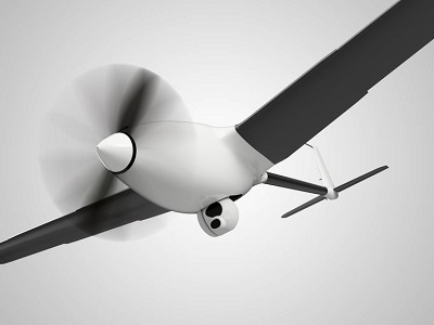
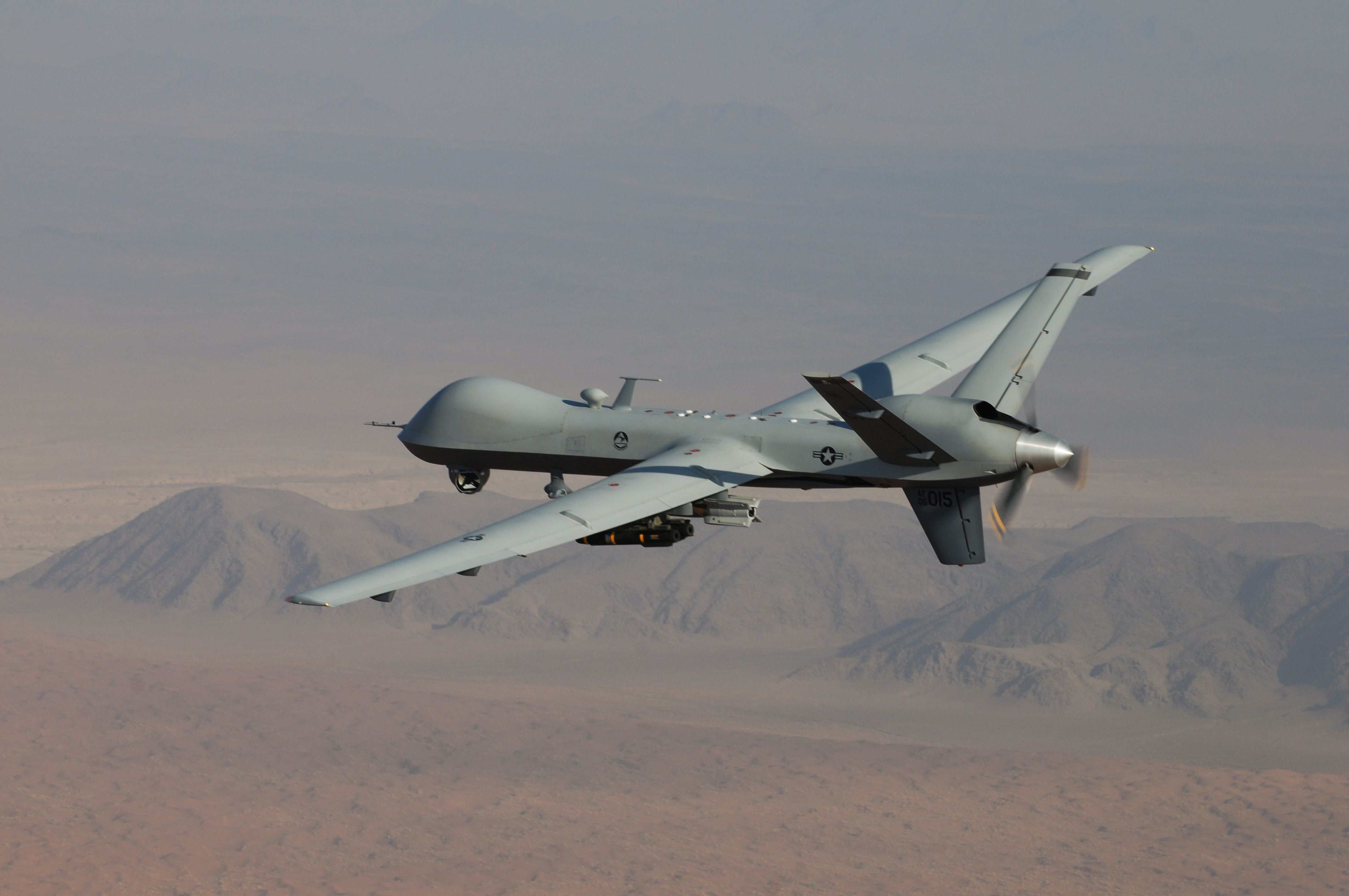
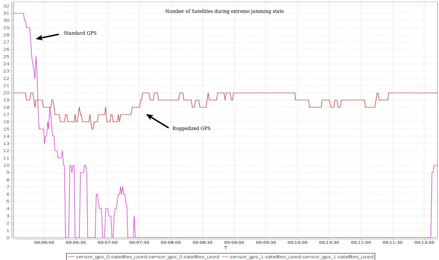
    DeltaQuad has successfully integrated an advanced GPS anti-jamming system into its unmanned aerial vehicle (UAV). The DeltaQuad drone equipped with the system was flown in autonomous mode close to an active military jamming system.

    Even while being hit directly by a military-grade GPS jamming platform, the system maintained a solid GPS lock and the vehicle managed to autonomously resume its mission without interruption.

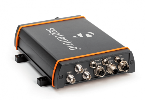
    For testing purposes, a ruggedized GPS-based navigation system was installed with the standard GPS-based navigation system. As the vehicle came in range of the GPS jamming system, the standard solution quickly lost all positional awareness, while the ruggedized system maintained a number of satellite locks, even while flying directly over the jammer at close range.

    Test results. (Image: Deltaquad)
    Test results. (Image: Deltaquad)

    In addition to the ruggedized GPS solution, the DeltaQuad UAV is equipped to maintain live aerial intelligence, even in tough environments. The transmission system on the DeltaQuad uses frequency hopping spread spectrum  (FHSS) techniques to mitigate attempts to disrupt the communication links, and also uses redundant video and communication links.

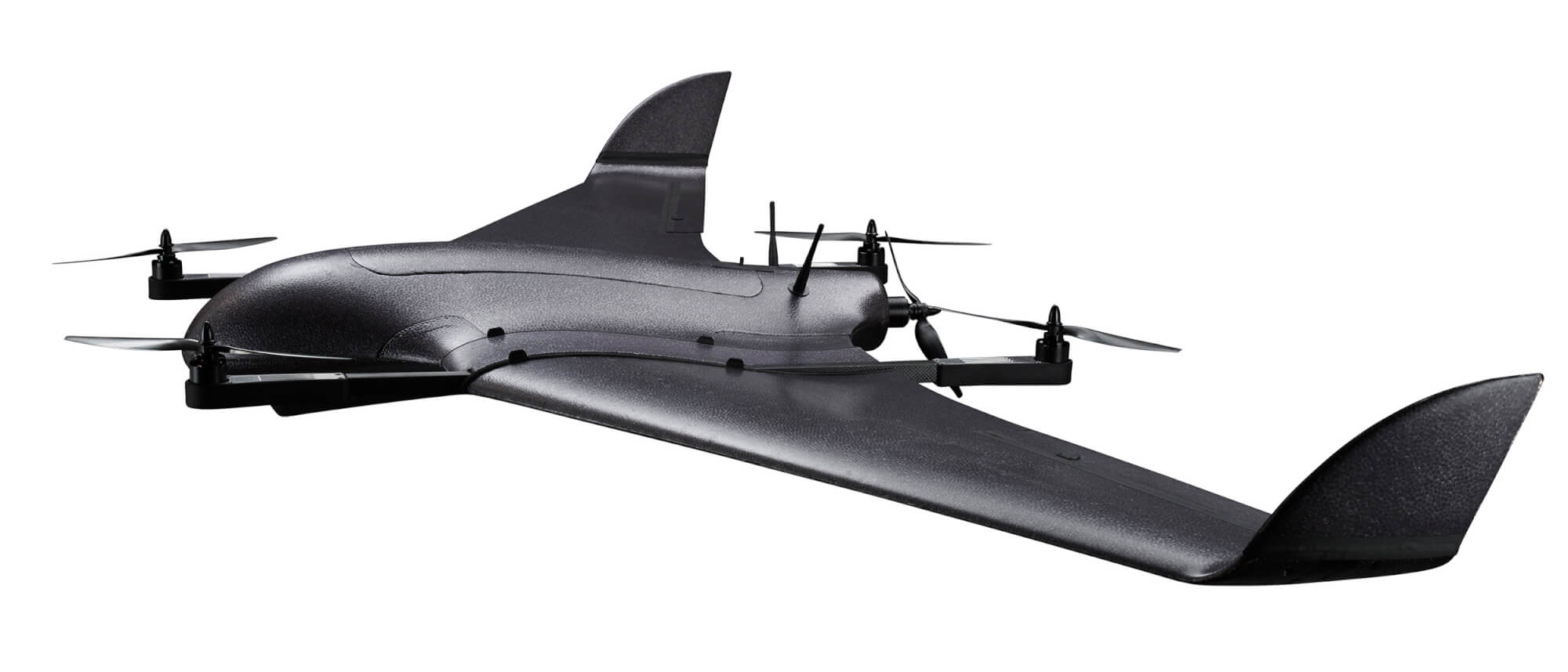
    The DeltaQuad is an industrial-grade vertical takeoff and landing (VTOL) fixed-wing UAV that performs fully autonomous surveillance missions. The platform offers a live video stream from a surveillance sensor for real-time reconnaissance missions.

  • Safran’s SkyNaute navigation system to equip H160M Guépard helicopters

    Safran’s SkyNaute navigation system to equip H160M Guépard helicopters

    Photo: Safran
    Photo: Safran

    Airbus Helicopters has selected Safran Electronics & Defense to supply its SkyNaute navigation systems to equip future H160M helicopters, developed as part of the France’s joint light helicopter program. The contract follows a December 2021 order from the French Ministry of the Armed Forces for 169 Guépard helicopters.

    SkyNaute is an ultra-compact hybrid GNSS/inertial navigation system based on Safran’s patented technology —  the hemispherical resonator gyroscope crystal. It offers virtually unlimited service life, a robust design for severe environments and ultra-high reliability, Safran said.

    With its combination of high integrity and precision, the SkyNaute navigation system guarantees a high level of performance, even when GNSS signals are absent or jammed. It will enable H160M crews to perform their missions in challenging theaters of operations, the company said.

  • Collins Aerospace launches M-code-compatible system for ground vehicles in Europe

    Collins Aerospace launches M-code-compatible system for ground vehicles in Europe

    Photo: Collins Aerospace
    Photo: Collins Aerospace

    Collins Aerospace has introduced NavHub-200M, a vehicle navigation system for the international market compatible with military code (M-code) receiver technology. The NavHub-200M is not controlled by the International Traffic in Arms Regulations (ITAR).

    Collins Aerospace made the announcement at Eursatory 2022, taking place June 13-17 in Parsis.

    NavHub-200M’s message formats and signal modulation techniques ensure faster and more accurate performance for ground vehicles on the connected battlespace, the company said.

    NavHub-200M provides assured positioning, navigation and timing (APNT) capabilities while improving overall resistance to existing and emerging threats to GPS, such as jamming and spoofing.

    “With GPS-based Selective Availability Anti-Spoofing Module (SAASM) receivers set to become obsolete, it is critical that M-Code receiver technology is made available to ground forces around the world as quickly as possible so they can trust that the signals they receive in a fast-moving, hostile environment are accurate and actionable,” said Ryan Bunge, vice president and general manager, Communication, Navigation and Guidance Solutions for Collins Aerospace. “Our NavHub-200M provides an improved resistance to jamming and interference, as well as advanced security features to prevent unauthorized access or exploitation.”

    NavHub-200M also includes the open interface standards and sensor-fusion capabilities required for a GNSS upgrade path, such as that for Europe’s Galileo constellation, as well as the ability to interface with key vehicle sensors such as the inertial measurement unit (IMU) and odometer, among others.

    Collins, a leader in APNT solutions for ground platforms, has delivered more than 10,000 navigation systems to military armed forced around the world.

    Attendees at Eurosatory can learn more by visiting Collins Aerospace at booth number C523.

  • BAE unveils advanced M-code receiver at ION Joint Navigation Conference

    BAE unveils advanced M-code receiver at ION Joint Navigation Conference

    New M-code GPS receiver enables precision strike capabilities in contested environments

    Image: BAE Systems
    Image: BAE Systems

    BAE Systems unveiled its newest advanced M-Code GPS receiver for guided weapons and other small applications at the ION Joint Navigation Conference, taking place this week in San Diego.

    The Strategic Anti-jam Beamforming Receiver – M-Code (SABR-M) enables precise geolocation and strike capabilities in highly contested battlespaces. It delivers accurate position, velocity, altitude and timing data, as well as strong protection against GPS signal jamming and spoofing – critical capabilities for unmanned aerial vehicles (UAVs), precision-guided munitions (PGMs), and missiles in threat environments.

    SABR-M integrates receiver technology with advanced antenna electronics in a small, hardened package designed to meet challenging performance requirements, such as weapons applications. It is the most capable integrated anti-jam GPS receiver and the first integrated M-Code receiver available for weapon systems, according to BAE Systems.

    “We’re making our full portfolio of military GPS solutions M-code-compatible to meet warfighters’ need for reliable positioning, navigation, and timing data to achieve their missions,” said Doug Lloyd, director of weapon systems GPS at BAE Systems. “SABR-M enables small platforms with challenging environmental conditions to get where they’re going despite interference.”

    The compact (4.5 x 6 x 1 inch) SABR-M meets size, weight, power, cost (SWaP-C) and thermal requirements for space-constrained military applications. It uses advanced beamforming technology to improve GPS signal reception and counter threat signals. SABR-M is form-compatible with previous generations of the field-proven SABR receiver, which are integrated on low-cost precision weapon systems and long-range cruise strike missiles.

    SABR-M will be fully qualified for production by the end of 2022. Production will take place at BAE Systems’ modern facility in Cedar Rapids, Iowa, which is in the final stages of construction. The purpose-built 278,000-square-foot factory and research center will be home to 700 military GPS experts in BAE Systems’ Navigation and Sensor Systems business.

  • OSNMA anti-spoofing tech now on PolaRx5 GNSS reference receivers

    OSNMA anti-spoofing tech now on PolaRx5 GNSS reference receivers

    The Septentrio PolaRX5. (Photo: Septentrio)
    The PolaRX5 GNSS reference receiver. (Photo: Septentrio)

    Septentrio, a leader in high-precision GNSS positioning solutions, has launched Open Service Navigation Message Authentication (OSNMA) on its high-end PolaRx5 reference receiver series.

    OSNMA offers end-to-end authentication on Galileo’s civilian signals, protecting receivers from GNSS spoofing attacks. OSNMA adds another layer of security to Septentrio’s existing AIM+ anti-jamming and anti-spoofing technology.

    This high level of resilience is especially important for reference receivers in applications that require assured PNT as well as in stationary critical infrastructure, which is especially vulnerable to GPS spoofing.


    The Septentrio PolaRx5 receiver with OSNMA technology will be showcased in booth 220 at the ION Joint Navigation Conference, taking place June 6-9 in San Diego.


    “We are excited to offer OSNMA anti-spoofing technology now in our scientific and reference GNSS receivers,” said François Freulon, head of product management at Septentrio. “The addition of OSNMA to Septentrio’s already strong anti-jamming and anti-spoofing technology takes our receivers to a new level as resilient positioning and timing solutions for industrial applications and critical infrastructure.”

    Septentrio has also updated the PolaRx5 product range with the latest RINEX format to support version 3.05 as well as version 4.0. With these updates, PolaRx5 becomes a leading scientific and reference receiver family supporting all of the new GNSS technologies introduced in 2022, Freulon said.

    The OSNMA authentication mechanism is also available on the mosaic GNSS module family and on Septentrio’s latest OEM boards.

  • Spirent Federal announces guest speakers for July training seminar

    Spirent Federal announces guest speakers for July training seminar

    Representatives from the U.S. Space Force and U.S. Army will present

    Photo:

    Spirent Federal, a leading provider of positioning, navigation and timing (PNT) test equipment, has announced the guest speakers for the 2022 Spirent Federal PNT Training Seminar.

    Guests include Stephen Burke from Space Systems Command and Ivan Franklin from the Assured Positioning, Navigation and Timing/Space (APNT/Space) Cross-Functional Team (CFT).

    The seminar will take place in person in Huntsville, Alabama, July 12-13, and will provide extensive training on PNT applications using Spirent’s simulation solutions.


    Spirent Federal Systems is exhibiting at the ION Joint Navigation Conference, which takes place June 6-9 in San Diego.


    Burke will provide an update on Military GPS User Equipment (MGUE) for Increment 1 and Increment 2, as well as a briefing on the Space Systems Command PNT restructure. Burke is deputy to the Senior Materiel Leader, GPS User Equipment Acquisition Delta, for the Military Communication and PNT Directorate within U.S. Space Force Space Systems Command.

    Franklin, Deputy APNT Signature Effort for the U.S. Army APNT/Space CFT, will share the latest on U.S. Army APNT, which is influencing the way soldiers operate in degraded and denied environments.

    “Providing hands-on training for customers, or prospective customers, and discussing nascent PNT advancements at our annual training seminar is the highlight of our year,” said Roger Hart, director of engineering for Spirent Federal. “We work closely with the U.S. government and military and are pleased Stephen and Ivan have accepted our invitations to share their vital information and expertise with the attendees.”

    Other seminar topics include

    • advanced jamming and in-the-field spoofing mitigation
    • encrypted GPS M-code and Y-code
    • complementary PNT, including inertial navigation systems
    • controlled reception pattern antennas (CRPA)
    • a patented approach to testing in anechoic chambers.

    View the full agenda and more information on registration at spirentfederal.com/training.

  • BAE Systems broadens compatibility of anti-jam GPS receiver

    BAE Systems broadens compatibility of anti-jam GPS receiver

    Image: BAE Systems
    Image: BAE Systems

    BAE Systems has expanded the capabilities of its Digital GPS Anti-Jam Receiver (DIGAR) by enabling beamforming with Trimble receivers, in addition to its own receivers.

    DIGAR’s beamforming capabilities increase the level of GPS jamming protection for aircraft by a million-fold, helping pilots execute their missions in contested environments.

    BAE Systems’ engineers in Cedar Rapids, Iowa, developed software to ensure the compatibility of its antenna electronics with industry-standard embedded GPS inertial navigation system (GPS/INS) technology, enabling fast communication with transmitter electronics for superior beamforming.


    BAE Systems is exhibiting at the ION Joint Navigation Conference, which takes place June 6-9 in San Diego.


    DIGAR beamforms with both BAE Systems receivers and Trimble GPS receivers embedded in aircraft GPS/INS, as well as federated GPS systems and stand-alone GPS receivers.

    “The modern battlespace has evolved, and peer state positioning, navigation, and timing threat systems are challenging our ability to conduct combat operations in the place and manner of our choosing,” said Greg Wild, director of Navigation and Sensor Systems at BAE Systems. “By combining DIGAR’s beamforming with trusted inertial navigation system data, we offer the highest level of jamming protection available today.”

    DIGAR is a high-performance military GPS-based system for fixed-wing, rotary-wing and unmanned airborne platforms. It combines field-proven antenna electronics, advanced signal-processing, and beamforming techniques to improve the reliability of positioning, navigation and timing data in the presence of disruptive electromagnetic signals.

    DIGAR is also compatible with the advanced M-code – delivering additional security to the warfighters who rely on it.

    BAE Systems’ anti-jamming GPS technology has defeated powerful and sophisticated adversary threat systems in testing and combat, and is available for airborne, shipborne and ground vehicle applications. The company’s military GPS business is based in Cedar Rapids, Iowa, where it is building a 278,000-square-foot state-of-the-art research and manufacturing facility scheduled to open this year.

  • Septentrio showcases solutions for GPS jamming and spoofing

    Septentrio showcases solutions for GPS jamming and spoofing

    Septentrio will demonstrate how simple it is to spoof or jam unprotected GPS receivers at the upcoming ION Joint Navigation Conference, which takes place June 6-9 in San Diego. The company will showcase how its resilient technology makes a difference for overall security and availability of positioning, navigation and timing (PNT) .

    Photo: Septentrio
    The AsteRx-U3 receiver. (Photo: Septentrio)

    Septentrio will hold a GPS spoofing demonstration, as well as a detailed comparison of jamming solutions from various high-end receivers. The integration of the latest anti-spoofing authentication mechanism, Galileo’s Open Service Navigation Message Authentication (OSNMA), will also be shown.

    “With our growing dependence on GPS technology, resilience of PNT is an important point of attention, especially for mission-critical applications, tactical ground or aerial vehicles as well as autonomous systems,” said Gustavo Lopez, market access manager, Septentrio. “Since the number of malicious jamming and spoofing attacks is on the rise, it is crucial to understand how various GPS receivers can be affected. We are pleased to explain and display this with specific examples at JNC this year.”

    Advance Interference Mitigation (AIM+) is an interconnected set of sophisticated anti-jamming and anti-spoofing technology components, securing GPS/GNSS receivers against various forms of interference.

    AIM+ is an interconnected set of anti-jamming and anti-spoofing technology components comprising a robust defense system against various forms of GPS/GNSS interference. Such resilience to jamming combined with anti-spoofing measures ensures the safety of autonomous machines, improves the security of GNSS-based infrastructure, and increases efficiency with extended PNT availability.

    OSNMA anti-spoofing authentication from Galileo is available on Septentrio receivers such as the mosaic module as well as the recently released AsteRx-U3 boxed receiver. Other products such as AsteRx-SBi3 also add inertial sensors for increased protection against spoofing.

    Septentrio will be at booth 220 in the ION JNC exhibit hall.

  • WingXpand’s expandable-wing drone stretches to 7 feet

    WingXpand’s expandable-wing drone stretches to 7 feet

    Photo: WingXpand
    Photo: WingXpand

    WingXpand has debuted a 7-foot expandable-wing drone that fits in a backpack. The drone was first revealed to the special forces community at the Special Operations Forces Industry Conference (SOFIC 2022) held May 16-19 in Tampa, Florida.

    WingXpand is U.S. made with a patented design that takes the small size and simplicity of a quadcopter and combines it with the horsepower of an airplane. WingXpand maximizes capability, efficiency and safety for the military and public safety officials. It can also be used  by farmers, surveyors and inspectors.

    WingXpand expands in less than 2 minutes. Though the full system weighs less than 10 pounds, it flies five times longer and carries ten times more weight than other drones of its size class, according to WingXpand. It can carry high-resolution cameras and other modular payloads such as a real-time pattern analysis system.

    WingXpand can reduce or replace the need for more costly, scarce or dangerous options. More than 10 WingXpand UAS can fit in a public safety vehicle, more than 30 in a pickup, and 250 on a standard airlift pallet.

    The WingXpand team provides end-to-end services, including pilot services, training, data analysis and sustainment.

  • Mayflower receives FAA approval for GPS anti-jam antennas

    Mayflower receives FAA approval for GPS anti-jam antennas

    FAA TSO-C190 authorization makes multi-platform anti-jam GPS navigation antenna (MAGNA) systems available for both military and commercial aviation use

    MAGNA-F anti-jam system. (Photo: Mayflower)
    MAGNA-F anti-jam system. (Photo: Mayflower)

    Mayflower Communications Company Inc. has received technical standard order Mayflower Communications (TSO-C190) authorization from the U.S. Federal Aviation Administration (FAA) for both models of its MAGNA GPS anti-jam product.

    Mayflower’s MAGNA GPS anti-jam products — MAGNA-Federated (MAGNA-F) and the MAGNA-Integrated (MAGNA-I)— can be installed on both military and civilian aircraft. Both MAGNA products offer simultaneous L1/L2 protection and can protect commercial and military GPS receivers.

    Mayflower’s MAGNA products build on Mayflower’s SWaP-optimized GPS anti-jam antenna technologies, which are optimized for small size, weight and power (SWaP), including small antenna systems. The MAGNA products were developed with sponsorship by the U.S. Navy SPAWAR and further improved under the U.S. Army PEO AVN to support GPS protection requirements for SWaP-constrained air, sea and ground platforms, such as fixed-wing/rotary aircraft, ships, UAVs and tactical vehicles.

    MAGNA-I anti-jam system. (Photo: Mayflower)
    MAGNA-I anti-jam system. (Photo: Mayflower)

    The MAGNA-F (NavGuard 710) has been extensively integrated, tested and flown in navigation warfare (NAVWAR) operational environments by the U.S. government on multiple aircraft platforms. MAGNA-F is the highest performance and smallest federated GPS anti-jam solution on the market in its class, utilizing a 3.5-inch diameter controlled reception pattern antenna (CRPA) compatible with existing fixed radiation pattern antenna (FRPA) footprints.

     The MAGNA-I (NavGuard 730) is a high-performance yet small GPS anti-jam integrated solution on the market, with a 4.5-inch diameter FRPA-compatible footprint. MAGNA-I simplifies platform integration and reduces lifecycle costs.  The MAGNA-I integrated anti-jam solution (antenna array integrated with antenna electronics in a single module) is designed for platforms with difficult integration challenges.   

    “The MAGNA GPS protection system provides pilots with improved GPS availability in a global environment with disrupted GPS signals,” said Triveni Upadhyay, Mayflower’s founder and president. 

    Mayflower Communications management team will be participating in the upcoming Joint Navigation Conference (JNC).

    Mayflower Communications is exhibiting its MAGNA suite of products at booth #216 at ION’s 2022 Joint Navigation Conference, which takes place June 6-9 in San Diego, California. Also at the conference, Naresh Jarmale, Mayflower vice president of engineering, will present a paper during Session B4: Military PNT User Equipment 2 – EGI and Platform Integrated PNT.

  • Raytheon to continue supporting US Air Force geospatial intelligence

    Raytheon to continue supporting US Air Force geospatial intelligence

    An MQ-9 Reaper on patrol. (Photo: Lt. Col. Leslie Pratt)
    An MQ-9 Reaper on patrol. (Photo: Lt. Col. Leslie Pratt)

    Contract to provide geospatial intelligence, infrastructure support and training for the Air Force Distributed Common Ground System

    Raytheon Intelligence & Space (RI&S), a Raytheon Technologies business, has been awarded a five-year indefinite delivery, indefinite quantity contract to continue geospatial intelligence (GEOINT) system mission support and training for the U.S. Air Force’s Distributed Common Ground System (DCGS).

    Under the DCGS GEOINT Field Support contract, RI&S will provide mission support and engineering services for the current DCGS weapon-system baseline as well as partnering with the Air Force to facilitate the transition to an open architecture.

    Open architecture will enable DCGS to more readily integrate data from the intelligence community and commercial providers, with the goal of using artificial intelligence to create multi-intelligence analysis.

    DCGS draws in data from airborne sensors aboard the RQ-4 Global Hawk, Mq-1 Predator, MQ-9 Reaper and other intelligence, surveillance and reconnaissance platforms all over the globe.

    Under the contract, RI&S will leverage its mission domain knowledge to ensure high mission availability to support end-to-end operations, from mission planning for an airborne sensor to data collection, processing and data discoverability for the DCGS Analysis Exploitation Teams in support of theater and National Command Authority.

  • CACI to demonstrate time-based navigation to support GPS

    CACI to demonstrate time-based navigation to support GPS

    Artist's impression of the CACI/York Space DemoSat scheduled to launch in January 2023. (Credit: CACI)
    Artist’s impression of the CACI/York Space DemoSat scheduled to launch in January 2023. (Credit: CACI)

    CACI International, a U.S. defense contractor, plans to demonstrate a supporting navigation technology for military use as part of its DemoSat launch in January 2023.

    CACI will launch two demonstration payloads on a York Space Systems satellite scheduled to fly to low Earth orbit in January aboard the SpaceX Transporter 7 rideshare.

    The payload will contain an alternative positioning, navigation and timing solution that will work in a contested space domain. It is designed to support rather than replace GPS.

    The technology is two-way time transfer and clock modeling technology. Two-way time transfer has been used for years on the ground, but in this case will be used in space. The low size, weight and power (SWaP) space-based PNT is expected to significantly improve multi-platform remote sensing.

    If the experiment is successful, CACI plans to offer the two-way time transfer PNT service to the military and other government agencies.

    CACI has completed the critical design review for the DemoSat. CACI and its partner York Space Systems will also demonstrate a tactical intelligence, surveillance and reconnaissance (TacISR) payload. The TacISR payload identifies and captures key signals of interest and operates with CACI’s Beast ground receiver to demonstrate real-time radiofrequency geolocation for deployed U.S. forces.

    “CACI expertise, systems, and technology help our customers maintain dominance in the increasingly contested space environment,” said Mike Hale, executive vice president of CACI’s Advanced Solutions Group. “We are very proud that CACI is launching a DemoSat payload into orbit – distinguishing our mission technology and transformative solutions for customer success.”