Contributing Editor Tony Murfin is on vacation this month. In place of his column, we bring you an advance look at an important UAV show as applied to surveying and mapping, and a story about drone use in surveillance.
In the zone
Legal issues, international market analyses and best practices will take center stage at the Interaerial Solutions Expo (IASEXPO), which will take place Sept. 26–28 in conjunction with Intergeo 2017 in Berlin, Germany.
At IASEXPO, the international UAV sector will be demonstrating the potential for civil and commercial UAV applications. IASEXPO will consist of an exhibition, forum and the FlightZone for UAV demonstrations. About 150 providers from 25 countries are expected to represent the young drone market at the IASEXPO.
IASEXPO’s practical forum will cover the latest topics with renowned experts. Visitors don’t have to walk far to switch between market overviews and expert presentations. The aim is to efficiently combine the trade fair and talks.
IASEXPO Forum 2016.
Regulations. As Germany’s drone regulations come into force this year, the legal aspects of using and operating UAVs is a key focus of the practical forum. Multicopters and drones weighing more than two kilograms can now only be flown in Germany by someone who holds a “drone driving license.” Pilots will be able to take the drone license test at the trade fair.
Frank Wichert from project management company procow will detail the requirements and reveal the precise procedure that pilots must follow. Speaker Ulrich Dieckert is a lawyer and expert on the approval process; he specializes in exceptions to operating bans that hinder drone work.
Market prospects. Kay Wackwitz, CEO of Drone Industry Insights, will present economic analyses of application opportunities and limits for UAVs, and discuss market developments and collaborations.
UAV Issue Manager Ralf Heidger from German traffic control (DFS) will discuss how DFS tackles the challenge of drones in the air space and tracking them within the air-traffic-management system.
Best practices. First-hand reports will provid examples of best practices in using drones for surveying and inspecting buildings and industrial complexes. Friedrich Wilhelm Bauer from Hannover University of Applied Sciences and Arts will highlight use of thermal-imaging technology for inspections. Benjamin Federmann from Aibotix-Leica will discuss the economic benefits of using drones in surveying and construction.
The German Association of Copter Pilots will weigh the question of whether to “make or buy” needed drones and services. Answers come from success stories in niche segments such as 3D modeling and smart framing. Maik Neuser from Westnetz and Carlo Zgraggen from Aeroscout will discuss inspections in the energy sector.
Other topics will be the use of drones in agriculture, forestry and disaster relief. Antoine Cottin from Carbomap and Bobby Vick from Precisionmapper will speak to the practical forum on drones used for surveying forests.
Drones on patrol
UAVs will soon be a common sight over border zones, crime hotspots and city streets in South Africa, as public safety and security officials and police departments discover the cost saving and efficiencies offered by drone patrol “armies,” according to Airborne Drones, a South African-based manufacturer of enterprise-grade drones.
Airborne Drones Vanguard 35-km long range surveillance drone ready to take flight. (PRNewsfoto/Airborne Drones)
Drones provide a solution to the limitations of other surveillance methods such as GPS tracking, CCTV camera observation, biometric surveillance and ground patrols. Aerial surveillance is increasingly being harnessed for security monitoring — traditionally, with costly helicopters. Drone surveillance present an faster and cheaper method of data collection.
Specialized security drones can enter narrow and confined spaces, produce minimal noise, and can be equipped with night-vision cameras and thermal sensors, allowing them to provide imagery that the human eye is unable to detect. In addition, UAVs can quickly cover large and difficult-to-reach areas, reducing staff numbers and costs, and don’t require much space for operators.
Autonomous, long-range security drones are at the vanguard of new policing methods, accoring to Airborne Drones. “Offering live video feeds to ground control stations, these drones can range autonomously over pre-programmed flight paths for extended periods of time, allowing for ongoing routine patrols across wide areas such as borders, maritime regions and high security installations.
Should an incident be detected, ground crews can then follow objects or intruders from a safe distance, providing visual support to safety and security teams. UAVs can provide detailed visual documentation of sites, enabling effective analysis, risk management and security planning.”
Around the world. Numerous countries are rolling out security drones to support public safety and defense initiatives”, says Airborne Drones. Israel has long harnessed advanced drones for military surveillance, and recently sold a fleet of “spy drones” to the Irish army.
The U.S. FBI has used drones for surveillance and tracking for several years. In Australia, the new $50 million Defence Cooperative Research Centre will develop long-range drones, automated vehicles and robots to help Australian soldiers fight the wars of the future. India is looking to military-grade UAVs for maritime and other surveillance and intelligence gathering.
In June, Brazil’s São Paulo became the first Latin American city to use drones for public security surveillance, and in July, Hamburg, Germany, deployed surveillance drones for the estimated 100,000 demonstrators at the G20 summit. In Australia’s New South Wales, the authorities are using helicopter and drone surveillance along the coast to protect holiday-goers from rip currents and sharks.
UAVs are also instrumental in managing transport infrastructure safety and security and event security, from event security infrastructure to spectator and crowd control and safety, to overall health and safety planning.
International Cartographic Conference much more than just cartography
I’ve always been a strong proponent of good cartography since my early days in geographic information systems (GIS) when I saw countless examples of very poor GIS map products. Regrettably, many early practitioners of GIS understood the software but lacked an appreciation and understanding of the good cartographic principals that are absolutely necessary to communicate spatial data well.
Consequently, the International Cartography Conference (ICC 2017) was an event I didn’t want to miss, especially since this was the first time in 39 years that this prestigious conference has been held in the United States.
The 28th annual International Cartographic Conference, ICC 2017, was held in Washington, D.C., July 2-7 with moe than 1,000 attendees from 80 countries representing government, academia and international companies.
Dr. Anderson was a research scientist and executive with the U.S. Geological Survey (USGS) for 35 years and is now the executive director of CaGIS and a faculty member of the College of Charleston. Lynn Usery is a senior scientist of the U.S. Geological Survey (USGS) and director of the Center of Excellence for Geospatial Information Science. ICC events have been key activities of the International Cartographic Association (ICA).
George Washington, First in the Arts of Mapmaking
In a keynote address, Director Robert Cardillo from the National Geospatial-Intelligence Agency (NGA) explained the interesting history of NGA citing George Washington, surveyor and mapmaker, as NGA employee number one.
Washington also appointed the nation’s first geographer and father of military mapping, Robert Erskine, whose work helped win the American Revolutionary War.
He also spoke of the Civil War use of manned balloons with telegraph wires tethered to the ground, used to verbally aim indirect artillery defilade fire. He continued the history lesson up to modern times, leading to imagery and Big Data.
Other keynote speakers included: Tom Patterson, senior cartographer, U.S. National Park Service; Lee Schwartz, geographer, U.S. Department of State; and Mikel Maron, Mapbox, OpenStreetMap Foundation.
Among the many interesting presentations was one from Payam Tabrizian, Anna Petrasova and Vaclav Petras, all Ph.D. candidates at North Carolina State University and special guests of CaGIS. They demonstrated their unique physical 3D sandbox system using low-cost gaming scanners and GRASS GIS.
Imagine being able to hold a GIS in your hands: feel the shape of the earth, sculpt its topography, and direct the flow of water.
This open-source interface physically, interactively manifests geospatial data, making GIS more intuitive and accessible for beginners, and creating new opportunities for developers. It consists of a near real-time feedback cycle of interaction, 3D scanning, point-cloud processing, geospatial computation and projection.
Peer Review
Although the word cartography was dominant, the conference covered a much broader range of topics, with a heavy emphasis on GIS and the science of mapping spatial data.
Dr. Anderson reminded me that the conference is an outgrowth of the International Journal of Cartography, published on behalf of the ICA. The publication is a peer-reviewed journal, and much of the conference provides an opportunity for originators to present their work to a live audience.
The conference ran from July 3-7 with more than 600 presentations and sessions. There were also several days of pre-conference meetings and field trips in the D.C. area. My colleague, William Tewelow, who has taken over my monthly Geointelligence Insider column, and I were both overwhelmed with the number of presentations.
William was only able to attend part of the conference, but found a wealth of new material to digest and write about during the coming year.
To give you an idea of the scope, below is a list of ICC Commissions (special interest groups), with each holding dozens of break-out sessions:
Art and Cartography
Atlases
Cartographic Heritage into the Digital
Cartography and Children
Cartography in Early Warning and Crisis Management
Cognitive Issues in Geographic Information Visualization
Education and Training
Generalization and Multiple Representation
Geospatial Analysis and Modeling
GI for Sustainability
History of Cartography
Location Based Services
Map Design
Map Production and Geoinformation Management
Map Projections
Maps and Graphics for Blind and Partially Sighted People
Maps and the Internet
Mountain Cartography
Open Source Geospatial Technologies
Planetary Cartography
SDI and Standards
Sensor-driven Mapping
Topographic Mapping
Toponymy
Ubiquitous Mapping
Use, User and Usability Issues
Visual Analytics
You can read the session abstracts through the online schedule. Additionally, ICC smartphone apps permit the download of text and some PowerPoint presentations. Go to your app store and search for and install “ICC2017.”
Once you install the app, you can search for topics or presenters. You can view most presentation summaries, and even view or download some PowerPoint presentations and PDFs. (I’m not sure how long these will be available, so act soon).
Expo and Posters
The ICC featured several map/poster areas including a collection of maps created by children from around the world. Also included was an expo area with booths from organizations and businesses.
Since this was a more academic conference that fell between GEOINT and the Esri User Conference, geospatial businesses were lightly represented. Below are video clips of some of the exhibitors.
Jill Saligoe-Simmel of MapDiva demonstrates Ortelius map design software for the Mac:
Liu Xiang Ming and Tao Wang of Top MAProducts at Qingdao Geotechnical Investigation & Surveying Research Institute. The comprehensive geoscience research institute focuses on geotechnical investigation, surveying, GIS and map culture. Ming and Wang were displaying some unique gift items with mapping themes. If you know someone with a gift shop or need some unique trade show or conference gifts, email Top MAProducts at [email protected].
All in all, this was a very robust conference that I wish I could have seen more of. Lynn, Eric and the organizing committee did a superb job with such a complex effort.
Northrop Grumman Corporation has been awarded a contract from the U.S. Air Force for technology maturation and risk reduction in support of next-generation navigation systems.
Under the $49 million contract from the Air Force Life Cycle Management Center, Northrop Grumman will provide the preliminary hardware and software architecture design for the Embedded GPS/Inertial Navigation System (INS)-Modernization, or EGI-M, technology. The modernized system is expected to be available for platform integration starting in 2019.
Northrop Grumman’s EGI-M will be based upon modular, open systems architecture to support the rapid insertion of new capabilities and adaptability based on unique platform requirements. Additionally, EGI-M will incorporate M-code-capable GPS receivers, which will help to ensure the secure transmission of accurate military signals.
“We are dedicated to ensuring mission success and the safety of warfighters by providing an EGI-M solution that offers robust, accurate and reliable positioning, navigation and timing [PNT] information, even in GPS-denied conditions,” said Dean Ebert, vice president, navigation and positioning systems business unit, Northrop Grumman Mission Systems.
EGI-M technology is designed for compatibility with current systems on legacy aircraft, allowing ease of integration and rapid adoption of new capabilities.
EGI-M will also comply with the Federal Aviation Administration’s NextGen air traffic control requirements that aircraft flying at higher altitudes be equipped with Automatic Dependence Surveillance-Broadcast (ADS‑B) Out by January 2020.
ADS-B Out transmits information about an aircraft’s altitude, speed and location to ground stations and to other equipped aircraft in the vicinity.
Spirent Federal Systems, a provider of GPS and GNSS simulators, has begun developing MNSA-capable GNSS simulators for the Modernized Navstar Security Algorithm.
Spirent Federal is developing software that will support M-code using MNSA. M-code is an updated GPS military signal that is being rolled out as part of the modernization of the current GPS constellation.
GPS modernization began in 2000 when the GPS Selective Availability feature was set to zero. Since that time, the U.S. Air Force has been working on newer generation satellites that will transmit new civilian and military signals.
Until now, AES and SDS have been the only methods authorized to be used within a GNSS simulator to produce M-code.
Spirent Federal Systems has been a provider of AES M-code and SDS M-code capable simulators for many years, but as the long awaited MNSA M-code signals become available, Spirent Federal Systems will be making this option available to authorized users on the GSS9000 series simulator.
The system provides significant immunity to jamming compared with a conventional GPS antenna, allowing the platform to operate over 100 times closer to the jammer whilst maintaining its GPS reception, the company said.
The system will be available to view on Cobham’s stand, hall 2b, stand E156, at the International Paris Air Show, which is taking place June 19-25.
The compact size and modularity of the DACU and CRPA, as well as being receiver independent, means that the system can be installed in land and marine applications. (Photo: Cobham)
“Cobham has been a global leader in development of anti-jam technology for over 20 years, and we are delighted to be launching launch our next generation anti-jam GPS system at Paris Air Show,” said David Bulley, vice president of Cobham Antenna Systems. “The system provides significant immunity to intentional or unintentional jamming compared with a conventional GPS antenna, thereby protecting mission critical systems that require assured position, navigation and timing information from GPS.”
The system consists of a 7-6005 anti-jam GPS digital antenna control unit (DACU) and a four-channel 20-7009 anti-jam GPS controlled reception pattern array (CRPA) antenna. Both units meet stringent airborne requirements making them ideal for new installations and retrofitting to fixed-wing, rotary-wing and UAV platforms.
The compact size and modularity of the DACU and CRPA, as well as being receiver independent, means that the system can also be installed in land and marine applications so offering a single solution for all platforms.
The high-performance, four-channel antenna and electronic system, offers the optimum balance between size, weight, power and cost. Intelligent, dual-band protection is provided with processing optimized to combat the threat environment.
In my April column, I introduced the basic concepts behind GPS anti-jam technology, along with a bit of history around its evolution. I knew this was a popular topic, but I didn’t anticipate the enormous amount of positive correspondence I’ve received since, including many inquiries about where to buy this technology and who is entitled to have it.
So this month we return to the controlled reception pattern antenna (CRPA) topic, to look specifically at the major suppliers of GNSS anti-jam technology in a bid to help you select the best fit for your requirements.
As mentioned in April, CRPAs can trace their roots back to military radar developments in the 1970s and 1980s. It’s no surprise, then, that the main players in the CRPA market tend to be large defense primes. But there are many smaller companies, universities and research institutions that also play in the CRPA arena these days.
What about export?
When GNSS jamming was a little-known military problem, the situation was simple: anti-jam was a military technology for military applications only. Later, as GPS evolved into a dual-use technology, critical infrastructure and civilian applications brought a new demand for anti-jam in non-military domains.
Confusion then abounded about who exactly is entitled to make use of anti-jam technology. There are two distinct factors here: security classification, and export control. Let’s clear these up.
Security classification is simple: If a product is classified, it is only available to customers who hold the appropriate level of security clearance. Usually it is the performance and vulnerabilities of a product that would attract a classified status. As you might expect for in-service military products, the military would not wish everyone to know the performance and weaknesses of its deployed technology. This is why many datasheets for CRPAs omit performance information.
The second issue is export control. This, of course, varies by country. In the U.S., a CRPA developed towards a defense program is likely to have International Traffic in Arms Regulations (ITAR) restrictions attached to it. In Canada, CRPAs are subject to the Controlled Goods Program. In the UK, CRPAs sit on the “dual-use” export control list, which recognizes that CRPAs have both military and non-military application. An export license is usually required.
Before I go any further, a little disclaimer: I am not making any product recommendations in this article. There are many things to consider when choosing anti-jam technology, and you should always consult a navigation warfare expert and carry out appropriate evaluations prior to choosing a product. You should also seek guidance from your own government regarding any restrictions on export or import.
With that out of the way, let’s look at the offerings of a few suppliers. This is by no means a complete list, but I did manage to catch up with a few of the major players to ask them about their anti-jam technology offerings.
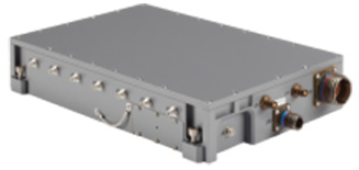
NovAtel
I spoke with Peter Soar, business development manager, Military and Defence, at NovAtel about NovAtel’s offerings.
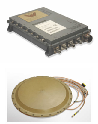
Peter Soar: “The GAJT-710 series are retrofittable GPS anti-jam products that combine a seven-element controlled reception pattern antenna (CRPA) and the antenna electronics in a single unit. The GAJT-AE-N is a GPS anti-jam antenna electronics system that supports a separated four-element antenna.”
Photo: NovAtel
Photo: NovAtel
Photo: NovAtel
Main features: “All three products protect the GPS L1 and L2 bands simultaneously, and are suitable for military (SAASM) receivers as well as open-signal receivers, normal civil receivers and ‘survey grade’ receivers. The wideband design means that the units are ready for M-code. In the GAJT-710, there are seven antenna elements for up to six independent nulls on both frequencies, and the GAJT-AE-N supports four antenna elements, for up to three independent nulls. All products use space-frequency adaptive processing for increased degrees of freedom. System messages provide an indication of jamming presence, even when the nulling is defeating the jamming.”
Intended market: “GAJT-710ML is optimized for land use, while GAJT-710MS is used for maritime and littoral applications. Both types are currently in use on mobile platforms and fixed installations. The GAJT-AE-N is optimized for smaller platforms such as unmanned air vehicles, and is currently in use on a variety of platforms. GAJT products have been shipped to customers in 16 countries to date.”
Example customers: “The GAJT-700ML (a predecessor to the 710ML) was selected for trials by the Canadian Army through the Build in Canada Innovation Program, with exercises performed on the Artillery Observation Post Vehicle (LAV III OPV). Both GAJT variants were selected for field testing by the U.S. Army Communication-Electronics Research Development and Engineering Center (CERDEC) through the U.S. Army Rapid Innovation Fund. The United States Naval Observatory (USNO) selected the GAJT-710ML to satisfy a requirement at sites throughout the Department of Defense Information Network (DoDIN). The GAJT-AE-N is deployed on the Schiebel Camcopter S-100, and was also selected for testing on the M777C1 Howitzer by the Canadian Army.”
Situation with regards to export: “All GAJTs are designed and built in Canada. As such, they are subject to the Controlled Goods Program of Canada, but they are free from ITAR for non-U.S. customers.”
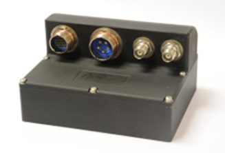
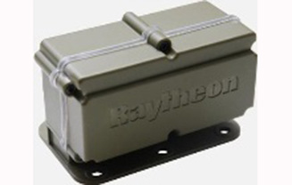
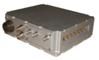
Raytheon UK
Some Raytheon products were mentioned briefly in the April column; I caught up with Alan Wright, business development executive, Force Protection, to get the latest information.
Alan Wright: “Raytheon UK offers a range of anti-jamming products ranging from high-performance products with multiple-element CRPAs to low size, weight and power products. Our current product lines utilize either analog or digital technologies to suit specific end-user requirements.”
Product
Image
Key Features
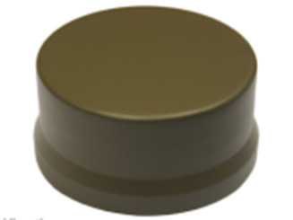
GAS-1
Analog technology, 7 antenna elements, switchable L1/L2 protection, minimal quiescent time delay, nulling, J/N, M-code signal bandwidth, AE/antenna integrated variant, fiber optic output variant.
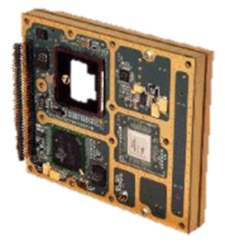
Digital technology, 5 antenna elements, simultaneous L1/L2 protection, low size, weight & power, STAP, nulling, J/N, direction finding, anti-spoof, jamming flag, M-code signal bandwidth.
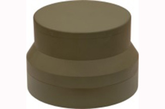
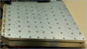
Landshield
Digital technology, integrated 4-element antenna, simultaneous L1/L2 protection, low size, weight and power, STAP, nulling, J/N, direction finding, anti-spoof, jamming flag, M-code signal bandwidth, switched antenna variant.
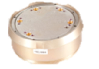
MiniGAS
Analog technology, integrated 4-element antenna, simultaneous L1/L2 protection or L1 with L2 passthrough, low size, weight and power, minimal quiescent time delay, nulling, jamming flag.
MicroGAS
Analog technology, integrated 2-element antenna, simultaneous L1/L2 protection, very low size, weight and power, minimal quiescent time delay, nulling.
Intended market: “With over 25 years’ experience, Raytheon UK is a world leader in the development, production and supply of GPS Anti-Jamming (GPS-AJ) systems to the majority of the world’s military forces (including the U.S. DoD and UK MOD), with solutions developed and certified for air, maritime and land applications. Raytheon UK has designed and manufactured in excess of 10,000 GPS anti-jam units for the worldwide market.”
Situation with regards to export: “GAS-1, ADAP and SAS are subject to U.S. ITAR restrictions. Landshield, MiniGAS and MicroGAS are free from ITAR and subject to UK export control.”
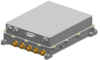
Rockwell Collins
I spoke with Al Simon, business development for navigation products/solutions, to get the latest on Rockwell Collins’ offerings. Rockwell’s portfolio includes some CRPA products aimed specifically at weapons. Al kindly provided the following table to summarize:
Product
Image
Platform
Key Features
Integrated GPS Anti-Jam System (IGAS)
Weapons (Embedded)
GPS receiver + AJ, nulling and beamforming, spatial, 20 in3, <2 lbs, up to 4 RF antenna inputs, 90+ dB J/S performance *, GPS (simultaneous L1 & L2), path to M-code
Strategic Anti-Jam Beamforming Receiver (SABR)
Weapons (Embedded)
GPS receiver + AJ, nulling and beamforming, STAP, 46 in3, <3 lbs, up to 7 RF antenna inputs, 120+ dB J/S performance*, GPS (simultaneous L1 & L2), path to M-code
NavStorm+
Weapons
Nulling, spatial, 6.9 in3, <.6 lbs, up to 5 RF antenna inputs, 20,000 G shock, 90+ dB J/S performance*, GPS (simultaneous L1 & L2), path to M-code
NavFire
Weapons
Nulling, spatial, 2 in3, <.2 lbs, 1 or 2 RF antenna inputs, 25,000 G shock, 85+ dB J/S performance*, GPS (L1 or L2), path to M-code
DIGAR-200
Airborne, Maritime, Ground
Nulling and beamforming, spatial, 218 in3, <11 lbs, up to 7 RF antenna inputs, 110+ dB J/S performance*, GPS (simultaneous L1 & L2), path to M-code
DIGAR-300
Airborne, Maritime, Ground
Nulling and beamforming, STAP/SFAP, 69 in3, <5 lbs, up to 7 RF antenna inputs, 125+ dB J/S performance *, GPS (simultaneous L1 & L2), path to M-code
Small Platform AJ (Pre-Production)
Ground, Airborne
Nulling and beamforming, STAP/SFAP, 45 in3, <3 lbs, up to 7 RF antenna inputs, 95+ dB J/S performance*, GPS (simultaneous L1 & L2), path to M-code
STAP (Space Time Adaptive Processing); SFAP (Space Frequency Adaptive Processing)
* Beamsteering mode. Actual performance is classified
Situation with regards to export: All listed products are unclassified, but are subject to U.S. ITAR restrictions.
Roke Manor Research
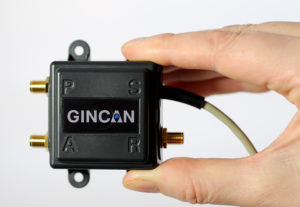
This column wouldn’t be complete without a few words on my own organization. Roke has been developing anti-jam CRPAs since the 1980s, but rarely offers its own products. Typically Roke develops bespoke anti-jam and anti-spoof technology for other defense organizations, including for some products already listed above. Examples of bespoke developments for more specialist markets include Gincan and the Helium antenna.
Photo: Roke
Photo: Gincan
Main features: Both these products are aimed at the commercial civilian market, but do also have defense interest. The Gincan is a very basic low-cost CRPA, with just two antenna elements. The Helium is a conical spiral design, using four antenna elements, and is primarily aimed at protecting GNSS in critical infrastructure. The Helium has excellent low-elevation performance. Both antennas feature very low latency, making them particularly suitable for timing receivers.
Intended market: The Gincan is primarily aimed at providing a basic level of anti-jam capability to the automotive mass market, including cars and trucks, but also has been adopted by some lightweight UAV platforms. The Helium is aimed directly at timing receivers for critical infrastructure, including mobile base stations, digital TV networks, stock exchange and financial institutions, and power and utility grids.
Example customers: Gincan has been delivered to 42 countries, with a mixture of commercial, defense and national security customers. Helium is a relatively new product, and is being trialed on infrastructure in two countries.
Situation with regards to export: Both products are unclassified and suitable for commercial use. They are subject to UK export control as dual-use items, and are ITAR-free.
Others
There are many other suppliers of CRPA technology — unfortunately, too many to cover in this column. Mayflower Communications offer a good range of CRPA products in the form of their NavGuard range. Some other suppliers include Cobham Antenna Systems, BAE Systems Rokar, Thales, Harris Corporation, L-3 Interstate Electronics and Lockheed Martin. I encourage you to contact these companies for the latest information if you are contemplating a CRPA product. If you’re a CRPA supplier and I’ve missed you, please feel free to post a link to your products in the comments section below.
So, that was a bit of a whirlwind tour through some of the products currently around. CRPAs come in all shapes and sizes, and they all have their own particular characteristics and subtleties.
I conclude by reiterating my earlier point. Always conduct a threat analysis, seek the help of a navigation warfare expert if necessary, and properly evaluate your choices. Happy choosing!
Rockwell Collins and QinetiQ have signed a global alliance agreement to collaborate on the development of next-generation, multi-constellation open-service and secure GNSS receivers.
The effort will support the mission needs of military, government and critical national infrastructure.
The family of receivers being developed will provide military, government and professional users the flexibility of selecting relevant GNSS capability to meet operational, geographical or budgetary needs and provide GNSS accuracy and timing.
This will improve safety, increase mission effectiveness and reduce operational costs for ground troops, vehicles and high-dynamics GNSS-guided weapons, Rockwell Collins said.
Rockwell Collins is major contractor for secure military GPS receivers and QinetiQ is an expert in the field of open-service solutions with access to critical satellite navigation system technologies that enable the development of multi-constellation solutions.
“This alliance agreement with QinetiQ is a great opportunity to bring together our strengths,” said Colin Mahoney, senior vice president of international and service solutions for Rockwell Collins. “Working together, our customers will experience unprecedented levels of availability, accuracy and assurance of positioning, navigation and timing for conducting their missions.”
“As we move into the era of multi-constellation satellite receivers, this market-leading agreement and the investments of both companies sends a clear message to our customers and shareholders that QinetiQ and Rockwell Collins are taking every step necessary to stay at the forefront of GNSS technical development and product delivery,” said Steve Wadey, CEO of QinetiQ. “The development will be centered in Europe, led from the U.K., supporting the global market.”
Lockheed Martin’s advanced tactical Group 3 unmanned aerial system (UAS) Fury is regularly flying long-range endurance test missions as the company prepares it for low-rate production.
In flight tests since May 2016, Fury has flown more than 200 hours and reliably demonstrated more than 12-hour endurance, while simultaneously operating 100 pounds of payloads, including electro-optical/infrared surveillance systems, voice communications relays, SATCOM links and multiple signals intelligence payloads.
The ramp-up in flight tests and demonstrations has grown significantly. Fury has completed more than 400 flight test hours, with significant increase in the second half of 2016.
“These flight tests have consistently proven that Fury is a true ‘anytime, anywhere’ tactical Group 3 aircraft,” said Kevin Westfall, director of unmanned systems at Lockheed Martin. “Fury can be deployed to execute strategic and tactical intelligence, surveillance and reconnaissance missions with endurance and capability previously found only in Group 4 systems. We continue to investment internally in Fury to deliver this proven, critical capability at the best value for our customers.”
Lockheed Martin regularly flies Fury at its operating base at the Yuma Proving Ground in Arizona where the team inserts pre-planned product improvements to further the Fury capability. Fury can support multiple payload integration, making it possible to efficiently execute various missions with a single aircraft.
Additionally, infrastructure is in place at Lockheed Martin manufacturing facilities to quickly deliver Fury and to rapidly scale up to full-rate production needs, Westfall said. Lockheed Martin is in discussions with potential domestic and international customers.
Built for outdoor operations, Duro combines a rugged enclosure with centimeter-accurate positioning. Leveraging design principles typically used in military hardware, the GNSS sensor is protected against weather, moisture, vibration, dust, water immersion and unexpected circumstances that can occur in outdoor long-term deployments. In addition to its ruggedness, Duro is ready to connect right out of the box. Primary industries for this product include: robotics, precision agriculture, mapping, military, outdoor industrial and maritime.
Photo: Swift NavigationDuro incorporates:
Dual-frequency RTK GNSS
Tough, military-grade hardware
IP67 rating
Weatherproof external enclosure design with M12 standard-sealed connectors
On-board MEMS IMU and magnetometer
Future-proof hardware with in-field software upgrades
Protected IO, including RS232 Serial Ports, 100mbit Ethernet, Event Inputs, PPS, PV, CANBus
More than $20 million for research on unmanned aircraft systems (UAS) was included in an appropriations package that Congress passed and the president signed into law last week to fund the federal government through the end of the fiscal year on Sept. 30. The funding for UAS research is $2.67 million more than last year’s budget request by the Federal Aviation Administration (FAA) to address a host of research challenges associated with integrating UAS into the national airspace system.
The measure’s section on appropriations for transportation agencies also includes $20 million above the 2016 budget request for the FAA’s air traffic control organization. The increase will provide for the hiring and training of new controllers and accelerating UAS airspace integration. The agreement also includes $11.5 million more than was requested for aviation safety activities for UAS integration, including the addition of six full-time positions to support the certification of new technologies and advance the FAA’s organizational delegation authorization (ODA) efforts and strengthen safety oversight.
VectorNav Technologies, a provider of embedded navigation solutions, announced at AUVSI’s Xponential that it will supply its surface mount VN-100 inertial measurement unit/attitude and heading reference system (IMU/AHRS) to Neya Systems for a custom version of that company’s UxAB module.
The back-packable Advanced Explosive Ordnance Disposal Robotic System (AEODRS) with integrated Neya Systems’ UxAB module. Photo: VectorNav
Neya Systems will in turn deliver its custom version of the UxAB platform to Northrop Grumman for that company’s Advance Explosive Ordnance Disposal Robotic System (AEODRS) Increment 1 delivery, an autonomous bomb-disposal robot, to the U.S. military. The AEODRS unmanned ground vehicle “back-packable” increment 1 system weighs less than 35 pounds and comprises the handheld operator control unit, communications link, mobility capability module, master capability module, power capability module, manipulator capability module, end effector capability module, visual sensors capability module, autonomous behaviors capability module and other minor components.
The UxAB is a a fully self-contained semi-autonomy and autonomy capability module that includes GPS waypoint navigation, multi-joint manipulator control (with self-collision avoidance), retrotraverse, return-to-comms and optional obstacle avoidance behaviors.
About the size of a postage stamp, VectorNav’s surface mount VN-100 is a temperature calibrated MEMS-based IMU/AHRS that includes 3-axis accelerometers, gyros and magnetometers. The module delivers to users a real-time 3D orientation solution that is continuous over the complete 360 degrees of motion at rates of up to 400 Hz. In addition to calibrated IMU and AHRS functionality, the VN-100 includes VectorNav’s Vector Processing Engine (VPE), a suite of proprietary sensor fusion algorithms running onboard the sensor that deliver real-time magnetic & acceleration disturbance rejection, adaptive signal filtering, dynamic filter tuning, and on-board Hard & Soft Iron compensation.
The VN-100 surface mount module is being integrated directly into the electronics board of Neya Systems’ UxAB platform. Neya is using the calibrated pitch and roll estimates to assist in its controller functionality, for example to provide warning when the robotic module is in danger of tipping. The VN-100 AHRS magnetometer-based heading solution is used for waypoint navigation. VectorNav is providing platform specific hard/soft iron calibration expertise to ensure the magnetometer-based heading solution takes into account the magnetic signature of the UxAB module and provides accurate navigation in a variety of environmental conditions.
AEODRS is the next generation of Explosive Ordnance Disposal robotic systems, designed as a follow-on and capability upgrade to existing deployed platforms. AEODRS is based on an open architecture, and Neya’s Autonomy Module will conform to the logical, electrical, and physical interfaces that are required by this architecture. Neya will be adapting its commercially available UxAB platform to comply with AEODRS Capability Module requirements.
This e-newsletter marks the sun setting on the career of GeoIntelligence Insider columnist and contributing editor Art Kalinski, long active in geospatial circles. Art is handing the journalistic reins to William Tewelow, a former intelligence specialist with the U.S. Navy. He also served a special assignment at the U.S. Department of Transportation and is currently a manager with the U.S. Federal Aviation Administration (FAA). The following discussion muses about the direction of our geospatial tradecraft in the coming years.
Tewelow’s Geointelligence column will alternate monthly with Mike Jones’ Defense PNT column. Every issue of this newsletter also brings you the latest news on both expanding fronts, hardware and software, in the defense and security realm.
Passing the torch
A conversation between retiring GeoIntelligence editor Art Kalinski, GISP, and his successor, William Tewelow, GISP.
Counter-drone technology research and operation efforts are helping to prepare for the potential threat of drone swarms. This Lockheed Martin concept is explored in “Technology That Counters Drone Swarms.” (Image: Lockheed Martin)
Art: A factor of life is that you just can’t predict with certainty where technology is headed or what the issues will be. Several weeks ago I attended a UAV (unmanned aerial vehicle) users group that seemed like a glimpse of the Wild West. I thought the key discussion topics would be the latest technology which seems to change almost weekly. That was not the case. The key discussions were the same as the early days of GIS: legal liability, jurisdictions, data ownership, administrative issues and so on, as the FAA changes the rules and regulations. I began to see that there will be more employment opportunities for lawyers than techies and pilots.
Although most of the attendees at the conference were geospatial/first responder users, I’ve learned of a growing community of non-traditional users such as power line inspectors and even tower painters. Yes, a tower painting company using tethered UAVs to paint in dangerous locations such as bridges, tanks and towers. At first I thought that would be difficult but by using a tethered system, heavy batteries are eliminated and bigger UAVs will permit heavier hoses, etc. Although the FAA had little interest in tethered balloons and UAVs, that could change as the size, altitude and potential crash radius expands.
This is just one example of how our technology is moving in many unplanned directions, everything from UAVs with new ways of collecting imagery to more exotic topics such as artificial intelligence, machine learning, augmented reality, virtual reality (VR) and gamification. The entire trade craft is evolving in ways I don’t think anybody could have predicted just a few years ago, much less a decade ago. It will be interesting to see where it goes.
William: You mentioned several new technologies mixing things up. Small sats are also making a significant impact. They are game changers. Imagine the traditional 2D satellite imagery base map. With the tech we have now 3D base maps are possible and have been for a long time with DEMS. Now, small sat imagery can be overlaid atop the 3D basemaps providing fresh imagery with periodicities of 24 hours or less, including multi-spectral. I’ve even seen small sat video overlays. That’s game changing.
Art: Not only small sats but the work being done with drone swarms is an exciting new area. If data needs to be collected in a hostile area or if flight clearance in a busy air corridor was limited, a swarm of maybe 100 drones could capture a wide swath of data at high resolutions, with multiple spectrums in very short order.
Virtual reality and augmented reality are two areas which have always intrigued me and they are coming to fruition. When I started out in GIS, I told people working for me to do the best we could building our regional database because at some point we would have construction workers wearing goggles that will augment the reality of what they are seeing with GIS data. That day is here and people are finally starting to do that. So, the entire concept of AR (augmented reality) and VR I find extremely exciting.
William: Yes, absolutely, in fact I believe they used drone swarms in the hostage situation in Algiers in 2014. And you are right. VR and AR use for first responders is especially critical. Say you’re a disaster relief person at night in a smoke-filled building. Night vision and thermal vision reach a practical limit. However, combining the vision devices with AR you may be able to navigate through the environment well enough. AR shows at least what should be there so accurate and timely data is critical. I can see this is where things are headed. Additionally, more mundane tasks such as design and modifications of structures could be enhanced. Work is already being done using AR and VR to facilitate the design process.
Art: VR started as fun and games but to me serious use VR is where the new and exciting action will be for geospatial practitioners. Virtual trainers I saw recently included small arms and artillery trainers for the military to a less exciting but equally impressive virtual trainer to teach arc welding and even spray painting a car. Significantly more critical was a VR surgical trainer where the muscle learning and hand eye coordination required is significant. It’s obviously quicker, easier and cheaper to practice virtually than on a real human or real equipment and the VR environment is just one short step away from surgical robots operating in remote locations.
William: Right, and you are touching on gamification, where VR can be used to train toward certain results. Take the military, for example, gamification can save all manner of resources – bullets, people, buildings the environment. Additionally, users can also scale up or down. The VR environment doesn’t just mean roads, maps or mountains. You can get down to a micro level.
Art: It’s interesting you mention that. One aha! moment I had years ago was at the first Esri User Conference in San Diego. I went through the map gallery. A lot of examples of different uses for GIS were on display and one person had created a map of the human circulatory system using ArcView Network Analyst. Looking at it I thought, of course, whether its blood vessels or interstate highways, it’s a network; so, this individual was using a geospatial tool to map the entire blood vessel network.
William: We are now in the realm of nano technology, where things are small enough to work on blood cells. Imagine steering straight towards a cancer cell by pinpointing a location in relation to the body.
Art: It’s almost like the movie “Fantastic Voyage” except in a virtual environment.
William: Yes. Being able to put the nano technology right where it needs to be means entering an age of focused medicine so that a pill releasing nano particulates doesn’t impact the whole body just the area needed. That’s another discussion in itself. Of course, all of that will have to be controlled, mapped and understood in terms of what it’s doing and where it’s going in relation to the body.
Art: One area that is very concerning to me is cyber. All of this stuff we’ve talked about is very vulnerable whether stealing data or doing damage to a society. Thwarting those threats is getting into machine learning, AI and other topics bordering science fiction.
William: Yes, and you are getting into artificial intelligence. IBM, Google, Amazon, Facebook, Microsoft and our three letter agencies are all investing into the world of Geospatial AI. I am not sure where GeoAI will end up but we can already see some hints. The amount of geospatial data is overwhelming and imagine the explosion happening with IoT. How will all that be managed? GeoAI will do pattern recognition so in effect GeoAI is assisted intelligence.
As an example let’s consider a high profile event. There are 1000’s of parameters that need to be tracked such as surveillance cameras, social media feeds, a suite of sensors, etc. Identifying critical patterns is crucial so Geospatial Assisted Intelligence can monitor the parameters of the event then notify the analyst when a triggering event occurs. That’s where the technology is going where it has to go.
Art: One has to have a truly dizzying intellect to keep track of all aspects of our technology. At the last NGA (National Geospatial-Intelligence Agency) conference, Director Cardillo talked extensively about open systems and open sources which are growing directions for the agency. I believe it’s good to get away from everything being “inside the tent” and taking advantage of the extensive capability in the broad geospatial community. The stated goal is to be able to develop needed geospatial tools, in an unclassified environment, not in months or weeks but literally in minutes to provide those tools to analysts in the field. Things have come so far from the day I was just happy to get a pen plotter to print a simple map.
William: It really is mind boggling. I was there when full motion video began and that was dynamic 2D imagery but then it made the jump to 3D dynamic imagery and my circuits fried. I still have a hard time comprehending all the data crunching that goes into it and it is now almost standard. The future is amazing. That is the direction I want to continue to explore.


 Among the many interesting presentations was one from Payam Tabrizian, Anna


 Built for outdoor operations, Duro combines a rugged enclosure with centimeter-accurate positioning. Leveraging design principles typically used in military hardware, the GNSS sensor is protected against weather, moisture, vibration, dust, water immersion and unexpected circumstances that can occur in outdoor long-term deployments. In addition to its ruggedness, Duro is ready to connect right out of the box. Primary industries for this product include: robotics, precision agriculture, mapping, military, outdoor industrial and maritime.
 About the size of a postage stamp, VectorNav’s surface mount VN-100 is a temperature calibrated MEMS-based IMU/AHRS that includes 3-axis accelerometers, gyros and magnetometers. The module delivers to users a real-time 3D orientation solution that is continuous over the complete 360 degrees of motion at rates of up to 400 Hz. In addition to calibrated IMU and AHRS functionality, the VN-100 includes VectorNav’s Vector Processing Engine (VPE), a suite of proprietary sensor fusion algorithms running onboard the sensor that deliver real-time magnetic & acceleration disturbance rejection, adaptive signal filtering, dynamic filter tuning, and on-board Hard & Soft Iron compensation.