South Korea issued a warning Thursday after detecting satellite signal disruptions that appeared to be coming from North Korea, according to the Korea Herald. The capital city of Seoul appeared to be the target.
Officials said North Korea discharged a large amount of radio waves to jam GPS signals in the region.
“We’ve detected signs that North Korea has been sending radio waves to the capital area since a month ago to disrupt GPS signals,” a senior government official said, speaking on condition of anonymity. “North Korea had been sending test waves since last month, but today, they discharged the largest amount.”
The warning was issued at 7:30 p.m. in Seoul, the adjacent city of Incheon and the surrounding Gyeonggi and Gangwon provinces.
The disruptions could cause mobile phones to malfunction and affect planes and ships that rely on GPS for navigation. No damage has so far been reported in the military or among civilians, officials said.
Since 2010, GPS disruptions have occurred three times in South Korea, and all have been blamed on the North.
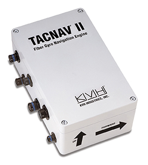
KVH Industries has begun shipping the first order of tactical navigation systems to BAE Systems for a prototype program designed to produce a new fleet of U.S. Army Armored Multi-Purpose Vehicles (AMPVs).
KVH’s TACNAV systems are designed to provide the vehicles with such critical elements as continuous heading and pointing data output and extremely accurate navigation regardless of GPS availability.
Deliveries of the tactical navigation systems are part of a recent purchase order that covers the life of the program, which is expected to run through 2020. The initial order of 34 TACNAV II systems is supporting prototype vehicles, and there is potential for an option for additional systems to support the low-rate initial production (LRIP) of the vehicles.
According to BAE Systems, the $1.2 billion AMPV program is designed to replace the U.S. Army’s Vietnam-era M113s and provide a significant upgrade that increases the service’s survivability, force protection, and mobility while providing for future growth potential.
M113 Armored personnel carrier n Vietnam, 1966. (Photo: U.S. Army)
“KVH is pleased to have been selected by BAE Systems for this important U.S. Army armored vehicle program,” says Dan Conway, executive vice president of KVH’s guidance and stabilization group. “KVH’s tactical navigation solution serves as a crucial resource for navigation and battle management, keeping soldiers safe and out of harm’s way wherever they travel.”
KVH TACNAV is a proven solution that has been serving soldiers for years in numerous armored vehicle programs, with more than 19,000 units fielded worldwide.
KVH’s TACNAV military vehicle navigation systems provide unjammable precision navigation, heading, and pointing data for vehicle drivers, crews, and commanders. KVH’s proprietary fiber optic gyro (FOG) technology is a differentiating factor in enabling the TACNAV systems to provide extremely accurate heading and pointing data, which is crucial for situational awareness.
The Armored Multi-Purpose Vehicle (AMPV) is the U.S. Army’s program to replace the Vietnam-era M113 Family of Vehicles. (Photo: BAE Systems)
The systems feature a compact design and flexible architecture ideal for today’s digital military. In addition, TACNAV is designed to integrate easily with Battle Management Systems (BMS), providing a vital component for effective battlefield management.
TACNAV systems are in use by the U.S. Army and Marine Corps, as well as many allied customers including Canada, Sweden, Great Britain, France, Germany, Spain, Egypt, Botswana, Australia, New Zealand, Saudi Arabia, Taiwan, Romania, Poland, Turkey, Malaysia, Switzerland, South Korea, Singapore, Brazil and Italy.
Australian Chief of the Defence Force Mark Binskin said that combat drones could take the place of some Joint Strike Fighters (JSFs).
A defense white paper states that Australia will buy 72 Joint Strike Fighters to replace current fighter planes “Classic” Hornets, six of which are now flying bombing raids over Iraq and Syria. But it leaves open the possibility of not buying a final squadron of roughly 25 JSFs to make up the 100-strong air combat fleet Australia needs.
Instead, the white paper states that to replace the newer, current squadron of Super Hornet aircraft from about 2030, alternatives will be “considered.”
Binskin said the department was keeping an open mind given the rapid improvements in armed drones or unmanned combat aerial vehicles, also known as UCAVs.
The ION 2016 Joint Navigation Conference (JNC) advance program is now available online. The JNC, sponsored by the Military Division of the ION, will be held June 6-8 (FOUO U.S. ONLY) at the Dayton Convention Center, Dayton Ohio; and the U.S. ONLY CLASSIFIED sessions will be held June 9 at the Air Force Institute of Technology on Wright-Patterson Air Force Base.
JNC 2016 will be the largest U.S. military positioning, navigation and timing (PNT) conference of the year, with joint service and government participation. Registrants can save $200 on conference registration by booking the hotel first, and entering a valid hotel confirmation number from one of the official conference hotels at the start of the registration process.
JNC 2016 will focus on technical advances in guidance, navigation and control (GN&C) with emphasis on joint development, test and support of affordable GN&C systems, logistics and integration. From an operational perspective, the conference will also focus on advances in battlefield applications of GPS; critical strengths or weaknesses of fielded navigation devices; warfighter PNT requirements and solutions; and navigation warfare.
PLEASE NOTE: Attendance Restricted
Conference attendance for both FOUO U.S. ONLY (June 6-8) and U.S. ONLY CLASSIFIED (June 9) sessions will be screened by the Joint Navigation Warfare Center and will be restricted to U.S. ONLY.
Virtually all unmanned systems, from drones to autonomous vehicles, use GPS location technology and advanced mapping. As systems evolve, and enemy threats become more sophisticated, new requirements are emerging. The U.S. military is out in front of this trend, developing unmanned autonomous systems at an even faster pace, with more ambitious goals, than the civilian market. This is borne out by several recent tests and announcements, all profiled individually at env-gpsworld-integration.kinsta.cloud. This month’s column rounds up their essential details for a skyview of the burgeoning field.
Publisher’s note: Defense PNT columnist Don Jewell will return next month.
An unmanned Black Hawk delivers an autonomous ground vehicle to a remote site in a demonstration for the U.S. Army of a joint robotic air-ground mission.
Carnegie Mellon University and Sikorsky Aircraft used an autonomous helicopter and an autonomous ground vehicle to demonstrate that ground and air robots can perform complex, cooperative missions. In an October 2015 demo, an unmanned Black Hawk helicopter picked up an unmanned ground vehicle (UGV), flew a 12-mile route, delivered the UGV to a ground location and released it.
The drop-zone collaboration promises to keep warfighters out of harm’s way. For example, this type of robotic mission could avoid warfighters’ exposure to hazardous conditions, such as chemically or radiologically contaminated areas.
The Black Hawk was equipped for autonomous operation by Sikorsky, a Lockheed Martin Co. It delivered a Land Tamer autonomous unmanned ground vehicle from Carnegie Mellon’s National Robotics Engineering Center to a remote site, where the vehicle performed environmental monitoring for potential contamination.
“We were able to demonstrate a new technological capability that combines the strengths of air and ground vehicles,” said Jeremy Searock, NREC technical project manager. “The helicopter provides long-range capability and access to remote areas, while the ground vehicle has long endurance and high-precision sensing.”
Once the helicopter lowered the vehicle to the ground, the Land Tamer drove itself off its transport platform to commence its leg of the mission. The vehicle, equipped with sensors for detecting chemical, biological, radiological or nuclear contamination, then found and surveyed several potentially contaminated sites, autonomously traversing six miles in the process. When the vehicle sensors detected potential contamination, operators were able to switch the vehicle from autonomous operation into a tele-operated mode for a more detailed exploration of the site.
A JPADs pallet lands on target, followed by several others still in the air, during recent testing. (Photo: US Army)
The U.S. Army’s Joint Precision Airdrop System (JPADS) has developed a new capability with a navigation alternative to GPS. In recent tests, JPADS were dropped from planes, and immediately determined their location using optical sensors to compare local terrain with commercial satellite imagery. The new system demonstrated navigation to its intended point, using nothing but imagery to guide it.
JPADS, largely guided by GPS, has already proven its importance in supplying troops with necessary materials and equipment, relying less on vulnerable convoys. However, the new JPADS also works with little knowledge of the aircraft’s location at the drop point.
Dropping critical supplies from the air has allowed the U.S. military to rely less on easily-ambushed truck convoys and helicopter resupply. Exposure to improvised explosive devices (IEDs) and ambushed convoys resulted in more than 3,000 causalities in Afghanistan and Iraq through 2007.
JPADS has proven to be an important tool in the Army’s logistics chain in many scenarios to supply troops with material and equipment in adverse terrain and remote locations when ground lines of communication are not possible or deemed too high a risk.
“This is a huge step forward for aerial resupply,” said Chris Bessette, Draper’s JPADS program manager. “By enabling the system to operate using imagery alone when dropped as high as 25,000 feet above Mean Sea Level and upwards of 20 miles away from the target depending on winds, we can ensure that JPADS is even more versatile so troops receive supplies like fuel, ammunition, food, and water in the safest manner possible.”
In August, U.S. Army Gray Eagle unmanned aircraft took part in manned-unmanned teaming exercises in South Korea, including streaming video and metadata to an AH-64 Apache helicopter while in flight. The MQ-1C Gray Eagle proved its ability to conduct operations in diverse weather condition, according to manufacturer General Atomics Aeronautical Systems (GA-ASI). The Gray Eagle is used by the Army for reconnaissance, surveillance, communications, convoy protection, IED detection and precision weapons delivery.
During the exercise, the Gray Eagle UAS streamed video and metadata via a line-of-sight data link directly to the helicopter from extended distances. The Apache then retransmitted the imagery to a One System Remote Video Terminal (OSRVT), allowing field commanders within the Tactical Operations Center (TOC) to receive both live Gray Eagle streaming video and retransmitted video sent by the Apache. Once the Gray Eagle was airborne, U.S. ground forces passed contact reports and target coordinates to operators in the aircraft’s ground control station. The operators were then able to direct the Gray Eagle’s sensors to positively identify and track the targets.
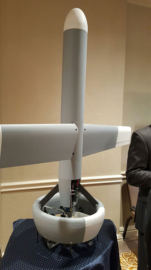
A V-Bat UAV from Martin UAV. Applications include aerial mapping, border patrol, shipboard operations and others.
Worldwide threats will make robotic and autonomous systems’ development important for decades, according to officials speaking at the Unmanned Systems Defense conference late last year.
GPS World’s contributing editor Kevin Dennehy wrote, “Because America has been at war for more than 14 years, unmanned technology has been developing at a rapid rate, perhaps even faster than emerging autonomous commercial systems. The replacement of even manned aircraft has some in the military establishment wary, but others know it’s only a matter of time before most vehicles, surface ships and aircraft are unmanned.”
The Secretary of the Navy said its current manned fighter plane, scheduled to see activity from now until 2037, may be its last to carry an actual human pilot.
The Navy’s Kraken drone munitions delivery system begins its mission underwater,then explodes past the surface to operate in the air. The Air Force also is developing small drones that can be launched and recovered by a larger aircraft after a mission is complete.
An Army initiative called Leader Follower includes rudimentary autonomous convoy operations capability with GPS and base mapping systems, autonomous steering and braking. Army program managers say the program is in staffing, but should be approved in a few months. A full-blown Automated Convoy Operations capability would allow any manned system, including tanks and mobile artillery, to operate autonomously. Last year, the Army and Lockheed Martin successfully demonstrated a driverless line-haul convoy with seven military trucks at speeds up to 40 mph.
Talking about a new generation
Lt. Gen. Michael Williamson, U.S. Army deputy to the assistant secretary of defense for acquisition, said the service is divesting its aging robotics and drone systems, which means future contracts for defense companies. “In 14 years of war, we have rode this equipment pretty hard,” he said. “We believe in modernization, but also looking to buy new systems, which is a new shift in order to gain a competitive advantage over our enemies, who are leveraging unmanned systems.”
The Defense Department recently established the Defense Innovation Unit, based in the San Francisco Bay area, to take advantage of rapid autonomous developments in the Silicon Valley.
Virtually all unmanned systems, from drones to autonomous vehicles, use GPS location technology and advanced mapping. As systems evolve, and enemy threats become more sophisticated, new requirements are emerging.
A surrogate LDUUV is submerged in preparation for a test to demonstrate the capability of the Navy’s Common Control System at the Naval Undersea Warfare Center Keyport in Puget Sound, Washington. (U.S. Navy photo)
In December 2015, the U.S. Navy tested its newly developed Common Control System (CCS) with a submersible unmanned vehicle in underwater missions in Puget Sound, Washington. The CCS successfully demonstrated its capability to provide command and control to a surrogate Large Displacement Unmanned Undersea Vehicle (LDUUV) — an underwater UAV destined for reconnaissance and surveillance missions.
CCS is a software architecture with a common framework, user interface and components that can be integrated on a variety of unmanned systems. It will provide common vehicle management, mission planning and mission management capabilities for the Naval unmanned systems portfolio. Operators used the CCS to transmit pre-planned missions via radio link to the LDUUV’s autonomous controller. In turn, CCS displayed actual vehicle status information to the operators. The vehicle was able to maneuver to the target areas and collect imagery.
“These tests proved that operators could use CCS from a single global operations center to plan, command and monitor UUVs on missions located anywhere in the world,” said Capt. Ralph Lee, who oversees the Navy’s CCS program at Patuxent River, Maryland. “This event also showed us that CCS is adaptable from the UAV (unmanned aerial vehicle) to UUV missions.”
CCS is intended to be compatible across all domains — air, surface, undersea and ground. The Navy initially plans to deploy the CCS on unmanned air vehicles. It will provide common vehicle management, mission planning and mission management capabilities for the Naval unmanned systems portfolio.
The U.S. Coast Guard has published guidance that allows mariners to use electronic charts and publications instead of paper charts, maps and publications.
“After consultation with our Navigation Safety Advisory Committee, the Coast Guard will allow mariners to use official electronic charts instead of paper charts, if they choose to do so,” said Capt. Scott J. Smith, the chief of the U.S. Coast Guard’s Office of Navigation Systems. “With real-time voyage planning and monitoring information at their fingertips, mariners will no longer have the burden of maintaining a full portfolio of paper charts.”
The Coast Guard published Navigation and Vessel Inspection Circular, NVIC 01-16, on Feb. 5 to provide uniform guidance on what is now considered equivalent to chart and publication carriage requirements.
Combining the suite of electronic charts from the U.S. hydrographic authorities and the Electronic Charting System (ECS) standards published in summer 2015 by the Radio Technical Commission for Maritime Services, the Coast Guard believes official electronic charts provide mariners with a substitute for the traditional official paper charts.
Electronic technology will also allow mariners to take advantage of information and data to enhance situational awareness during voyage planning and while underway.
“Mariners have been requesting the recognition of this capability for some time,” Smith said. “When you combine the new expanded Automatic Identification System carriage requirement and the capability that an ECS provides, it should provide a platform to move American waterways into the 21st century.”
The new guidance applies to vessels subject to U.S. chart, or map, and publication carriage requirements codified in Titles 33 and 46 CFR and provides a voluntary alternative means to comply with those requirements.
“Together, with our industry and international partners, we are leveraging modern technology to contribute to the safety, security and prosperity of our nation,” Smith said.
General Atomics Aeronautical Systems Inc. (GA-ASI) has successfully flown the Predator B/MQ-9 Reaper Extended Range (ER) Long Wing craft.
The long-wing Predator is retrofitted with improved long-endurance wings, greater internal fuel capacity and additional hard points for carrying external stores. The flight took place Feb. 18 at GA-ASI’s Gray Butte Flight Test Facility in Palmdale, Calif., on a test aircraft.
GA-ASI is a a manufacturer of remotely piloted aircraft (RPA) systems, radars, and electro-optic and related mission systems solutions.
“Predator B ER’s new 79-foot wing span not only boosts the RPA’s endurance and range, but also serves as proof-of-concept for the next-generation Predator B aircraft that will be designed for Type-Certification and airspace integration,” said Linden Blue, CEO. “The wing was designed to conform to STANAG 4671 [NATO Airworthiness Standard for RPA systems], and includes lightning and bird strike protection, non-destructive testing and advanced composite and adhesive materials for extreme environments.”
During the flight, Predator B ER Long Wing demonstrated its ability to launch, climb to 7,500 feet (initial flight test altitude), complete basic airworthiness maneuvers, and land without incident. A subsequent test program will be conducted to verify full operational capability.
Developed on Internal Research and Development (IRAD) funds, the new wing span is 13 feet longer, increasing the aircraft’s endurance from 27 hours to more than 40 hours.
Additional improvements include short-field takeoff and landing performance and spoilers on the wings that enable precision automatic landings. The wings also have provisions for leading-edge de-ice and integrated low- and high-band RF antennas.
An earlier version of Predator B ER featuring two wing-mounted fuel tanks is currently operational with the U.S. Air Force as MQ-9 Reaper ER.
The long wings are the first components to be produced as part of GA-ASI’s Certifiable Predator B (CPB) development project, which will lead to a certifiable production aircraft in early 2018.
Further hardware and software upgrades planned for CPB will include improved structural fatigue and damage tolerance, more robust flight control software and enhancements allowing operations in adverse weather.
In honor of the space program that benefits more than 3 billion users worldwide, the 2nd and 19th Space Operations Squadrons celebrated the second annual GPS Heritage Gala Friday, Feb. 19, at the Space Foundation in Colorado Springs, Colorado.
The two squadrons perform the satellite command and control mission for the GPS constellation. The gala celebrated GPS’s achievements as well as honored the people, both past and present, who enable the program’s success.
Attendees give a standing ovation to Tech. Sgt. Israel Del Toro Jr. after he shared his story during the GPS Heritage Gala Del Toro was the guest speaker. (U.S. Air Force photo/Tech. Sgt. Julius Delos Reyes)
Lt. Col. Todd Benson, 2 SOPS commander, opened the ceremony and said, “What an incredible evening. I think this is well deserved…This is a great opportunity to come together and I am truly humbled to be in a company of our guests tonight.”
Benson also acknowledged the GPS milestones since last year’s gala, including the four spacecraft added to its now 41-satellite constellation.
“My hat’s off to all of you who played a role in that,” he said.
With the theme, “Setting the Gold Standard,” the event featured Tech. Sgt. Israel Del Toro Jr. as the keynote speaker. Del Toro is a Tactical Air Control Party specialist responsible for calling in airstrikes while on the frontline. He received severe burns when an improvised explosive device exploded near him while he was on a patrol in Afghanistan in 2005.
He said GPS has come a long way. “People think it is just a navigation service, but they don’t realize the military aspect and how it impacts us.”
Del Toro said, “I wouldn’t be here without GPS. A lot of my teammates would probably not be here without GPS. I want you to know that you make a big impact to us as operators. We truly respect you.”
He also parted with a message of teamwork and hope to the GPS community.
“When I got hurt, [my wife] saw every one of my teammates from all parts of the world visit me. She saw TACP Airmen I had just met a year prior at Osan Air Base, fly out to see me. She realized why I love the Air Force. We are family; we take care of our family. And I truly appreciate that,” Del Toro said.
Del Toro also borrowed from Lou Gehrig’s farewell speech and said, “A lot of you may think I have gotten a bad break but I am the luckiest man out here because I work with the greatest men out there. I have a wife who gives me strength. I have a son who’s all my motivation. So yeah, I might have gotten a bad break, but I’ve got an awful lot to live for.”
As part of the event, the 2 and 19 SOPS also presented the GPS Lifetime Achievement award to Jay Uebelhart for his continued 30 years of service to the success of GPS; and the 2015 Greatest Contributions to GPS Launch to Marc Drake for the launches of GPS SVN 71, 72 and 73 in 2015.
Lt. Col. Samuel Baxter, 19 SOPS commander, concluded the event and said, “We truly love our job because we are entrusted with arguably the most famous satellite constellation there is. But more than that, we get to work with such dedicated people – Airmen, civilians, contractors. You all serve an important role.”
The U.S. Air Force’s Joint Service Systems Management Office (JSSMO) has awarded Northrop Grumman Corporation an order to support embedded GPS/inertial navigation system (INS) pre-Phase 1 modernization efforts.
Integration of inertial technology with GPS systems across all military platforms — some, such as munitions, are already so equipped — could have far-reaching effects. The move reflects the military’s concern over GPS vulnerabilities in challenged environments.
The Military GPS User Equipment (MGUE) program is developing M-code-capable GPS receivers, which are mandated by Congress after fiscal year 2017 and will help to ensure the secure transmission of accurate military signals.
Under the $4.8 million order, Northrop Grumman will perform trade studies, assess the state of development of MGUE for upcoming applications, and contribute to architecture development for next-generation GPS/inertial navigation systems.
The JSSMO is responsible, among other things, for a GPS lab in the Department of Defense that helps develop and test software for GPS systems used throughout the military.
One of the systems it maintains is the Blue Force Tracker (BFT), which is used by all military branches and can track friendly units regardless of their location. Not only can the system see where the unit is located, it can also determine whether or not a unit is moving and what form of transportation it is using.
Aviation Use. The updated GPS/inertial navigation system will also comply with the Federal Aviation Administration’s NextGen air traffic control requirements that aircraft flying at higher altitudes be equipped with Automatic Dependence Surveillance-Broadcast (ADS-B) Out by January 2020. ADS-B Out transmits information about an aircraft’s altitude, speed and location to ground stations and to other equipped aircraft in the vicinity. The modernized system is expected to be available for platform integration starting in 2018.
Inertial market to top $8.9 billion by 2020
The inertial navigation system (INS) market is projected to grow from $4.64 billion in 2015 to $8.87 billion by 2020, according to a January 2016 reported from research firm ReportLinker. Factors driving the global INS market include the increasing number of aircraft, technological advancements in navigation systems, increasing demand for accuracy in navigation, and availability of smaller components at lower cost.
“Commercial platform application segment to witness the highest growth during the forecast period,” says the report.
Key applications considered in the market study are naval, airborne, land and commercial platforms. The overall INS market is dominated by the naval platform segment. However, the commercial platform segment is projected to grow at a comparatively higher CAGR during the forecast period of 2015 to 2020, primarily driven by the demand for new aircraft in response to the burgeoning rise in air travel and congestion of airspace.
Recent advances in inertial technology have replaced the mechanical components with electronic ones, particularly micro-electro-mechanical sensors (MEMS). Overall focus has remained on increasing the accuracy and reducing weight of the INS.
The major companies profiled in the report include Northrop Grumman Corporation (U.S.), Honeywell International Inc. (U.S.), Sagem (France), Rockwell Collins (U.S.) and Thales SA (France), among others.
Lidar
Lidar market grows with 3D
Anew market report on light detection and ranging (lidar) technology says that the demand for lidar is increasing in line with an increase in the demand for 3D scanning and 3D imagery.
According to the report, the global lidar market is anticipated to expand at 15 percent annually from 2014 to 2020, growing from a value of $225 million in 2013 to $605 million in 2020.
Lidar enables direct measurement of 3D structures and underlying terrain with high resolution and high data accuracy. The adoption of lidar technology is slowly penetrating in various government sectors such as roadways, railways and forestry management, among others.
However, the lidar market faces challenge related to the complexity in interpreting the output data, because of the lack of data-set standardization.
The 80-page research study is titled LiDAR Market: Global Industry Analysis, Size, Share, Growth, Trends and Forecast 2014–2020, available for sale from Transparency Market Research.
The lidar market can be segmented based on types into airborne and terrestrial lidar and based on applications into coastal, forestry, transportation, infrastructure, defense and aerospace, transmission lines and flood mapping, among others.
Geographically, the lidar market is dominated by North America owing to high adoption of advanced 3D imagery technologies by the U.S. government. Europe follows with a minimal difference in the market share. A large number of key players are based in Europe and are involved in making innovations to meet the requirements of consumers in different applications.
The report has been segmented by type, application and geography. It also includes the drivers, restraints, opportunities and value chain of the global lidar market.
Imagery
RoboParachute drops
The U.S. Army’s Joint Precision Airdrop System (JPADS) has developed a new capability exploiting a navigation alternative to GPS. In recent tests, JPADS were dropped from planes, and immediately determined their location using optical sensors to compare local terrain with commercial satellite imagery. The new system demonstrated navigation to its intended point, using nothing but imagery to guide it. The new JPADS also works with little knowledge of the aircraft’s location at the drop point.
JPADS, largely guided by GPS, has already proven its importance in supplying troops with necessary materials and equipment, relying less on vulnerable convoys.
Contractor Draper will continue developing the system to eliminate current obstacles, such as cloud cover that degrades the vision-aided navigation system’s ability to compare vision sensor inputs with satellite imagery. These imagery-data analysis technologies could be used to help guide military freefall paratroopers and autonomous aerial vehicles.
In September 2013, the night before he won the prestigious ION Kepler Award, Dr. John Betz and I were enroute to an ION (Institute of Navigation) dinner when he casually mentioned that he was thinking about writing a book. The natural journalistic inquiries about subject and timing brought a surprising response. The draft of the first chapter was already complete and it would be about PNT space systems or GNSS (Global Navigation Satellites System) if you will. Not just GPS, but all space-borne (satnav) PNT (position, navigation and timing) systems and augmentations.
When I asked John exactly why he was writing the book he replied, “I am writing the book for several reasons. First, there is a shortage of books that uniformly treat all satnav systems, rather than emphasizing a single system. There are a lot of common and complementary characteristics that become clear when all are treated in a uniform and consistent way.
“Second, this is a chance to provide an integrated perspective on satnav systems engineering. Lastly, I’ve learned a lot in the last 17 years, and I want to document it in an organized way.”
I, of course, offered to help in any way I could. I mentioned that I would very much like to review the book when it was finished. Not too much was said about the book until the next year at the very same event, when John mentioned the book would be ready for publication in the first quarter of 2016. Again I offered to review the book, and this column is that promised review.
First of all, there can be no doubt that Dr. John Betz, a MITRE Fellow, is qualified to author this engineering tome about all matters pertaining to space-borne PNT. Indeed, if I were to fully recite his impressive curriculum vitae, it would be longer than the entire space allocated for my column, so I will make do with the short paragraphs that accompanied the Kepler Award.
Dr. John Betz, winner of the ION 2013 Kepler Award.
“Dr. John Betz contributed to the international interoperability and compatibility efforts leading to the design of the GPS L1C civil signal. His Binary Offset Carrier (BOC) technique is used for the GPS M-code signal, and adopted by satellite navigation systems developed by Russia, Europe, China, Japan and India.
“Since 1997, Dr. Betz has worked on the NAVSTAR GPS and also on international negotiations concerning compatibility and interoperability of GPS with the world’s satellite navigation systems. For his role in the United States/European Union negotiations that established compatibility and interoperability between GPS and Galileo in 2004, he received the U.S. State Department’s Superior Honor Award.
“More recently, Dr. Betz provided critical analysis related to GPS modernization, recommending affordable enhancements to address increasing threats and to shape the architecture of military GPS for decades to come. Col. Bernard Gruber, [then] director of the GPS Directorate said, ‘I can think of no one else in the past two decades, military or civilian, who has influenced this critical national asset to the same degree as Dr. Betz’.”
I asked Dr. Betz what he liked most about writing the book, what he disliked the most, and would he do it again?
“Don, some chapters just flew — it was really fun to write them,” he said. “And I really like the color graphics, even in the print edition. It was challenging to find the time, given my work schedule. That was probably the most difficult part. It’s amazing when I look back. It was a little more than two years from start to submitting the manuscript. I had planned on 400 pages and it’s 640 pages. And yes, I would do it all again.”
Scope
The scope of this engineering reference is exhaustive in nature where PNT is concerned. The work is balanced between original content and a compilation of academic papers by numerous expert authors. Certainly, Dr. Betz gives credit where credit is due; he often recommends other volumes, texts and papers for enlightenment. However, for me his personal and professional insights and clear explanations of highly technical issues are what make this a compelling volume.
In his introduction, Dr. Betz describes his effort:
“This book describes satellite-based navigation and timing (satnav), the engineering of systems that transmit radio frequency (RF) ranging signals from a constellation of satellites so that a passive receiver can determine time and its position. The intent of this book is to provide a consistent and integrated depiction of the engineering behind satnav.”
If a PNT or GNSS constellation, or even a small group of satnav vehicles, is in orbit today — such as WAAS, EGNOS and QZSS — John describes their makeup and contribution to the overall PNT solution in great detail that is understandable to both the academic and layman alike.
Insights
I have personally been involved with satnav in one fashion or another for 40 years. Frankly, I thought I was well versed in the subject. Yet, in every chapter of John’s book, I either learned something new or had an issue explained that I obviously did not understand quite as well as I thought. There is something for everyone interested in satnav in this wonderful book, regardless of their level of involvement or sophistication with PNT.
References
The book contains exhaustive tables, references, figures and formulas for all levels, which is why I am sanguine this book will become an invaluable reference and textbook for the military as well as any university dealing with educating students concerning satnav and PNT issues.
When I finished reading the 640-page volume, I had added more than 40 blue “stickies” to mark figures or tables for future reference.
This book is a treasure trove for PNT engineers and satnav experts, but it’s readability is such that even if you are only slightly curious about how space-based PNT works, you will find it an educational and enjoyable read.
For instance, on page 29, Table 2.1 summarizes the nominal constellation characteristics, 16 for each system, between GPS (US), GLONASS (Russian), Galileo (European) and the BeiDou (Chinese) constellations. While this will probably only serve as riveting cocktail repartee at something like an ION function, it is also just good to know, fun facts if you will. It might even serve as a Jeopardy category one day.
Bottom Line
Dr. Betz begins his lengthy but enjoyable tome with an explanation of satnav; takes the reader through the various space-borne PNT systems and augmentations on orbit today; describes the signals, the errors and the various pluses and minuses of each system; and then delves into PNT receiver design and describes how each signal is received and utilized.
After reading the book I asked Dr. Betz if he thought or hoped the book would be used as a textbook. He replied, “I hope it gets used in multiple ways. It can certainly be used by practicing engineers as a reference and for in-depth exploration. I hope its contents and structure make it useful as a textbook, because the book includes theoretical and applied questions at the end of many chapters that should help students learn how to extend and apply the theory and practice laid out in the book. Also, I hope its structure is conducive for use in teaching.”
While the jury is still out on whether this is a engineering textbook, a satnav reference manual, a primer on modernized PNT, or perhaps a compendium of all three, if you care at all about modern-day GNSS and all it enables, this book should be in your library.
Until next time, happy navigating, and I hope you enjoy the book.
Abstracts must be received by Feb. 15 and must be written for public release. For more information and instructions on submitting an abstract, visit the ION website.
The JNC is the largest U.S. military positioning, navigation and timing (PNT) conference of the year with joint service and government participation. For Official Use Only (FUOU) U.S. ONLY sessions will be held June 6-9 at the Dayton Convention Center in Dayton, Ohio. The U.S. ONLY CLASSIFIED sessions will be held June 9 at the Air Force Institute of Technology.
The ION Joint Navigation Conference, sponsored by the ION’s Military Division, will focus on technical advances in guidance, navigation and control (GN&C) with emphasis on joint development, test and support of affordable GN&C systems, logistics and integration.
From an operational perspective, the conference will also focus on advances in battlefield applications of GPS; critical strengths or weaknesses of fielded navigation devices; warfighter PNT requirements and solutions; and navigation warfare.
The ION JNC features more than 200 operational presentations on a diverse array of topics. It also features a technical exhibit and showcase of GNC technology products and services and operational product demonstrations.
Attendance Restricted. Conference attendance for both FOUO U.S. ONLY (June 6-8) and U.S. ONLY Secret Clearance (June 9) sessions will be screened by the Joint Navigation Warfare Center and will be restricted to U.S. ONLY.
A surrogate LDUUV is submerged in preparation for a test to demonstrate the capability of the Navy’s Common Control System at the Naval Undersea Warfare Center Keyport in Puget Sound, Washington. (U.S. Navy photo)
The U.S. Navy tested its newly developed Common Control System (CCS) with a submersible unmanned vehicle during a series of underwater missions at the Naval Undersea Warfare Center Keyport in Puget Sound, Washington.
The CCS successfully demonstrated its capability to provide command and control to a surrogate Large Displacement Unmanned Undersea Vehicle (LDUUV).
CCS is a software architecture with a common framework, user interface and components that can be integrated on a variety of unmanned systems. It will provide common vehicle management, mission planning and mission management capabilities for the Naval unmanned systems portfolio.
During the test events in Dec. 7-11, operators from Submarine Development Squadron 5 Detachment UUV used CCS to plan and execute several surveillance and intelligence preparation missions. The CCS sent pre-planned missions — via radio link — to the LDUUV’s autonomous controller and displayed actual vehicle status information to operators during the test. The vehicle was able to maneuver to the target areas and collect imagery.
“These tests proved that operators could use CCS from a single global operations center to plan, command and monitor UUVs on missions located anywhere in the world,” said Capt. Ralph Lee, who oversees the Navy’s CCS program at Patuxent River, Maryland. “This event also showed us that CCS is adaptable from the UAV (unmanned aerial vehicle) to UUV missions.”
Teams from the Navy’s Strike Planning and Execution and Unmanned Maritime Systems program office (PMA-281), Naval Air Warfare Center Weapons Division, Space and Naval Warfare Systems Command Pacific, John Hopkins and Penn State universities worked together to design, develop and test the software before executing the live demonstration in December.
“We had a really talented group of people working on this project,” said Vern Brown, who supports the CCS Advanced Development team based in China Lake. “It was exciting taking the CCS concept of controlling an undersea vehicle from inception early in the year to a successful in-water demonstration.”
CCS is intended to be compatible across all domains — air, surface, undersea and ground. The Navy initially plans to deploy the CCS on unmanned air vehicles. It will provide common vehicle management, mission planning and mission management capabilities for the Naval unmanned systems portfolio.
“Ultimately, CCS will eliminate redundant efforts, encourage innovation and improve cost control for unmanned systems,” Lee said.
Personnel supporting the Navy’s CCS program review data during a test event in December 2015 at the Naval Undersea Warfare Center Keyport in Puget Sound, Wash. (U.S. Navy photo)