Category: Mapping

  • Esri ArcGIS Field Maps beta supports Eos Arrow GNSS

    Esri ArcGIS Field Maps beta supports Eos Arrow GNSS

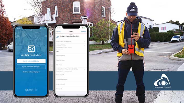
    A new Esri mobile app, ArcGIS Field Maps, will be released in its first beta in July, with the final version expected to be released in September.

    According to Esri, Field Maps will combine the following capabilities into a single app:

    • Simple map viewing and markup
    • High-accuracy field data collection and inspection
    • Battery-optimized location tracking
    • Work planning and task management
    • Turn-by-turn navigation

    Field Maps also will include a new web app, integrated with ArcGIS, that can be used to configure and deploy maps optimized for your mobile workforce needs, create and assign tasks to mobile workers, and create and share views of worker locations.

    Arrow support included

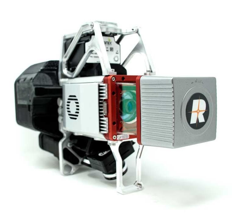
    The inaugural beta includes support for Arrow GNSS receivers’ high-accuracy locations, elevations and metadata, according to Eos Positioning.

    ArcGIS Field Maps will provide the combined functionality of five Esri mobile apps: ArcGIS Collector, ArcGIS Explorer, ArcGIS Tracker, ArcGIS Workforce and ArcGIS Navigator.

    In the first beta version, users will be able to perform markups, work with read-only maps, and work with MMPKs, including  high-accuracy GPS locations and metadata from Arrow GNSS receivers.

    Photo: Eos Positioning
    Photo: Eos Positioning

    Customers who have been wanting to take advantage of high-accuracy GNSS data in apps such as Explorer and Tracker will now be able to with the beta release. Customers who would like to have field crews able to access read-only maps with high-accuracy, for instance (such as during utility locates), this is now a possibility. In addition, crews can take advantage of high-accuracy GPS tracks while tracking.

    ArcGIS Field Maps will also support the two formerly Collector-exclusive Eos solutions Eos Locate and Eos Laser Mapping.

    Eos Locate. This high-accuracy underground mapping solution will be available in ArcGIS Field Maps right away in the first beta release. A single fieldworker will be able to perform real-time, high-accuracy mapping of underground assets using the same workflow he or she had previously used with Collector and Arrow GNSS.

    Eos Laser Mapping. Similarly, laser offsets with Arrow GNSS receivers and LTI laser rangefinders will be available in the first beta of ArcGIS Field Maps. Learn more about laser offsets, including the three workflows for using them, here:

    “We are incredibly excited for the new opportunities ArcGIS Field Maps brings to expand our partnership with Esri,” Eos CTO Jean-Yves Lauture said. “Now our joint customers will be able to use the Arrow GNSS receivers with Field Maps to access high-accuracy location when simply viewing and marking up maps and when logging location tracks.”

    Eos Positioning told its customers, “We encourage all Eos customers currently using Collector, Tracker and/or Explorer to join the beta. Meanwhile, Collector, Tracker and Explorer are planned to continue working as usual, according to the roadmap Esri has outlined.”

  • Using location data in the fight against COVID-19

    Using location data in the fight against COVID-19

    San Francisco, captured by HERE’s 3D mapping technology. (Image: HERE)
    San Francisco, captured by HERE’s 3D mapping technology. (Image: HERE)

    In 1854, English physician John Snow mapped the London cholera epidemic to determine the exact location of a contaminated water pump on Broad Street, pioneering the use of location mapping and data to manage public health crises.

    Today, governments and public health officials are utilizing location data to help fight the COVID-19 global pandemic. Location data and maps are at the frontlines to aid emergency responders and healthcare providers, while GIS professionals, data scientists and many others rely on maps and location data to allocate supplies, manpower and assets where they are needed most.

    Data as a source of truth

    Location data has been one of the most valuable tools to guide crisis response. By referencing professionally managed, comprehensive geospatial databases, public health officials are able to precisely locate key medical and emergency resources, including hospitals, medical centers, medical and emergency services, pharmacies, and food and water distribution centers.

    For example, the HERE location platform continually validates the freshness and features of its map through thousands of data sources. This includes field-collected data, third-party data from government sources, and crowdsourced data from expert communities. Taken together, the process rapidly delivers clear, timely location information to end-users such as key medical stakeholders.

    It is critical that all levels of government — local, state and federal — have access to these types of valuable datasets during times of emergency. In response to the pandemic, we have seen incredible agility from facilities that have been converted to provide critical medical services.

    For example, the Javits Center in New York City has been used as a field hospital, a sports facility has been converted into a drive-through testing center, and schools are being used to distribute food. By tracking these updates, authorities have real-time awareness of these facilities and their availability to provide services.

    Use Case #1

    Social distancing efficacy

    At this stage of the pandemic, the Federal Emergency Management Agency has tapped into location data to track the efficacy of social distancing policies and the spread of the virus. It’s valuable to map the virus’s spread for many reasons, but a few key reasons include:

    • Predicting the movement of COVID-19. By mapping the spread, we can proactively align the medical supply chain behind these predictions.
    • Understanding the effectiveness of social distancing. Social distancing is one of the most powerful ways to stop the spread of the virus. By tracking the efficacy of these measures and regulations and ensuring that citizens are complying with shelter in place, we’re able to predict how we are able to slow or flatten the spread.
    • Predicting the economic impact. As we consider reopening America for business, it’s important to understand where the virus is most prevalent, and the timeline for recovery.

    Use Case #2

    The strained medical supply chain

    The coronavirus has caused strain across most industry supply chains, but most notably, the medical supply chain. Medical resources, including hospital beds, masks and life-saving ventilators have become scarce and unevenly distributed.

    In times of crisis, with thousands of lives at stake and the potential for further economic fallout, it’s critical that public health officials are equipped with authoritative, comprehensive datasets to guide decision-making. When organizations are equipped with this valuable data, they can harness the power of location data for good and follow in the footsteps of the location data pioneer John Snow.

  • Taking to the field during the coronavirus pandemic

    Taking to the field during the coronavirus pandemic

    City officials in Sarasota, Florida, kept their staff actively working during COVID-19 social distancing mandates by training and tasking them with mapping utility data in the field.

    The city’s plan to rebuild its GIS database had an estimated five-year timeline. GIS Coordinator William Rockwell suggested to city manager Tom Barwin that those unable to work from home be trained to collect the data. Rockwell worked with Sarasota IT Director Herminio Rodriguez to calculate the cost of acquiring enough GNSS receivers for the idle staff to use, and discovered a substantial cost savings.

    Hands-on training took place in the Sarasota City Hall parking lot, with trainees practicing social distancing. (Photo: Eos Positioning)
    Hands-on training took place in the Sarasota City Hall parking lot, with trainees practicing social distancing. (Photo: Eos Positioning)

    “By implementing this project, we not only keep city staff productive, but we’ll also be collecting data that would otherwise cost hundreds of thousands of dollars if we outsourced the work,” Rockwell said.

    Training from a Distance. Rockwell obtained affordable Arrow 100 GNSS receivers from an Eos Positioning distributor and hosted small-group training sessions in the city hall parking lot. Employees from a multitude of different departments were trained, such as a parking enforcement officer and a transportation planner.

    All employees were carefully kept six feet apart. From a maintained distance, Rockwell explained the basic concept of data collection using high-accuracy Arrow 100 receivers with ArcGIS Collector.

    The new team mapped 93% of street lights and road signs in one month. (Photo: Eos Positioning)
    The new team mapped 93% of street lights and road signs in one month. (Photo: Eos Positioning)

    The employees took turns collecting sample data so Rockwell could address any initial concerns. He also gave each of them a printed map series, created in ArcGIS Pro, that showed the city divided into 28 grids. This allowed the team members to easily mark off where they collected data each day.

    At the end of each day, the workers synced their data, collected by the Arrow 100s, to ArcGIS Online, which allowed Rockwell to monitor progress.

    To date, 14 field workers have collected 93% of the city’s 6,000 street lights and 16,000 road signs. Although the 30-day project pilot has finished, the city plans to collect the remaining lights and signs, as well as the city’s 35,000 trees, later this year. High-accuracy GIS data collection has received encouraging feedback from management.

    “I’m thrilled the city is supporting this initiative,” Rodriguez said. “To be able to take employees doing very, very different jobs and put them in the field — this wouldn’t have been possible in a normal environment. We are excited that everyone is chipping in.”

  • CHC Navigation introduces BB4 UAV and AlphaUni lidar combination

    CHC Navigation introduces BB4 UAV and AlphaUni lidar combination

    Lidar series paired with professional drone provides multi-platform, high-accuracy 3D laser scanning for geospatial and mapping professionals

    CHC Navigation (CHCNAV) has launched the multi-rotor BB4 drone and AlphaUni 300/900/1300 lidar.

    Photo: CHCNAV
    Photo: CHCNAV

    The combination of the AlphaUni 300/900/1300 lidar and BB4 UAV solutions creates a comprehensive and versatile range for 3D mapping and geospatial data acquisition in land, air and marine applications.

    “The purchase of a 3D mobile mapping system is too often constrained to a specific purpose, such as airborne or ground survey,” said George Zhao, CEO of CHCNAV. “A lot of our customers expressed the need to have a professional lidar solution that can be used in different scenarios, offering optimal adaptability to their current and future needs.

    “With our AlphaUni series, we are now introducing an innovative response with a multi-platform lidar system that can be used with an aerial or marine drone, on a vehicle or carried as a backpack,” Zhao said. “In addition, the long flight autonomy of our new BB4 UAV allows missions over large areas in a single flight for exceptional productivity.”

    AlphaUni lidar series

    Photo: CHCNAV
    Photo: CHCNAV

    The new AlphaUni series enhances CHCNAV’s Alpha Mobile Mapping family with a light, versatile long-range laser scanner systems available on the high-end market.

    The series provides optimized data sets powered by advanced GNSS/inertial navigation system (INS) sensors and long-range Riegl scanners.

    AlphaUni’s design adapts to a variety of applications and can be installed on a variety of platforms, including multi-rotor UAV, fixed-wing vertical-takeoff-and-landing (VTOL) UAV, vehicles, rail trolleys, backpacks, boats and more.

    BB4 UAV

    The BB4 UAV is a high-end multi-rotor drone optimized for the CHCNAV AlphaUni 300/900/1300 lidar series. Its modular design simplifies deployment in just a few minutes.

    Its 7-kg payload breaks the capacity barrier, and more than 45 minutes of flight time increases the airborne lidar survey ability.

    The redundant CHCNAV and DJI inertial measurement unit (IMU) and GNSS units provide reliable centimeter real-time kinematic (RTK) positioning, meeting the demand for high accuracy in the geospatial and mapping industry.

  • GeoCue releases 3D UAS systems with Applanix inside

    GeoCue releases 3D UAS systems with Applanix inside

    Photo: GeoCue
    Photo: GeoCue

    GeoCue Group has released the True View 615 and True View 620 UAS lidar 3D imaging systems. The True View systems are compact, survey-grade 3D imaging sensors designed for small unmanned aerial systems.

    True View 615 and 620 are equipped with Riegl’s miniVUX-2UAV laser scanner integrated with dual photogrammetric cameras. Position and orientation is provided by an Applanix APX-15 (True View 615) or extreme accuracy APX-20 (True View 620).

    All True View 3D imaging systems are bundled with Applanix POSPac, True View EVO post-processing software and True View Reckon data management solution.

    The Riegl laser scanner and dual photogrammetric cameras have been carefully configured to provide a fused lidar/imagery field of view of up to 120°. The system includes full post-processing software that generates a stunning ray-traced 3D colorized point cloud and geocoded images.

    An upgrade path will be available to promote a True View 615 to a True View 620 by adding the Applanix APX-20 external inertial measurement unit.

    The True View product line gives mappers and surveyors the ability to deliver high-quality analytic data with exact accuracies. These deliverables are generated using workflows and tools within GeoCue’s post-processing software, True View EVO. Examples of derived products include bare Earth models, profiles, cross sections, topographic contours, volumetric analysis and more.

    “Our Quanergy-based True View 410 has rapidly become the standard for general purpose drone 3D Imaging, where moderate vegetation penetration and accuracies of 5 cm RMSE are adequate,” said GeoCue’s President, Lewis Graham. “The True View 615/620 provides a solution for situations where deeper vegetation penetration, wire extraction and extreme accuracy are required. These are great new additions to the True View product line.”

    The True View 615/620 will be available for shipment late June.

  • How aerial imagery helps protect natural resources

    How aerial imagery helps protect natural resources

    Photo: Lake County Forest Preserves
    Photo: Lake County Forest Preserves

    An upcoming GPS World webinar shows how high-definition aerial imagery can help protect and maintain natural resources.

    In Transforming Land and Asset Management with HD Aerial Imagery, four
    mapping experts discuss how Lake County Forest Preserves of Illinois uses HD aerial imagery to manage and track changes.

    The webinar, sponsored by Nearmap, takes place June 25 at 1 p.m. EDT / 10 a.m. PDT / 7 p.m. (1900h) Central European Time. Registration is free.

    Managing and protecting the nearly 31,000 acres of the preserves is no small task, so the ability to see the environment at scale in crystal-clear clarity is a must. Aerial imagery provides an “eye in the sky” to get better context of truth on the ground.

    Lake County Forest Preserves uses Nearmap aerial imagery to:

    • monitor and track change over time with historical and current captures
    • assess and address invasive species growth with high-resolution imagery
    • manage remote work challenges during COVID-19 to locate assets.

    Joining Brett Clark of Nearmap are three experts from Lake County Forest Preserves.

    Nick SpittlemeisterNick Spittlemeister
    GIS Analyst, Planning and Land Preservation Dept.
    Lake County Forest Preserves District (IL)

    Nick Spittlemeister has been with Lake County Forest Preserves since 2016, working to create an enterprise solution that employs web GIS in all facets of the organization. He helped the district secure a license with Nearmap in 2018 and has deployed it across their GIS system, from Desktop software to web applications and native apps. He has been using GIS for more than 15 years and holds a bachelor’s degree in geography from Northern Michigan University.

    Dave CassinDave Cassin
    Manager of Landscape Ecology
    Lake County Forest Preserves District (IL)

    David Cassin’s remote sensing training began in the US Navy (1990-94) where he was trained as an Intelligence Specialist / Air Photo Interpreter, put into practice during Operation Desert Shield / Storm. Post military service, he continued his craft in college with incorporation of ArcGIS. He combined his skillset and his love of nature by getting a degree in Natural Resource Management. Integrating remote sensing skills into landscape scale restoration projects by utilizing historical air photos and land survey data, he is able to determine historic land uses and alterations. Specific to Nearmap, he was able to map populations of Phragmites australis (an invasive species in Illinois) by utilizing the fall 2019 Nearmap imagery remotely during the COVID-19 stay at home order.

    Kevin KleinjanKevin Kleinjan
    Senior Engineer
    Lake County Forest Preserves District (IL)

    Kevin has utilized aerial imagery and geospatial technologies for over 25 years to inform and support planning and infrastructure related decisions. He utilizes Nearmap’s high-resolution imagery with multiple captures throughout a calendar year to analyze and update infrastructure assets quickly and accurately from both the office, and in the field using mobile devices. This enables him to efficiently manage the District’s sign shop, site amenity and heavy equipment crews. He has dual degree in Landscape Architecture and Geography from South Dakota State University and is a Registered Landscape Architect in Illinois and Wisconsin.

    Brett Clark

    Brett Clark
    Senior Account Executive
    Nearmap
    Brett graduated from Brigham Young University with a degree in communications. He was employee #2 for Nearmap, U.S., and focuses primarily on serving the public sector – both state and local. Brett lives in the Indianapolis area with his wife and three daughters.

    Register for the free webinar here.

  • Mapping tool helps LA County residents find food resources

    Mapping tool helps LA County residents find food resources

    Screenshot: FoodFinder
    Screenshot: FoodFinder

    The non-profit 211 LA County and Slingshot Aerospace have unveiled an online mapping tool that allows users to quickly identify and locate more than 2,000 food resources within the county during and after the COVID-19 pandemic.

    211 LA County is a non-profit organization providing the official information and referral source for health and human services in LA County. Slingshot Aerospace is a situational intelligence platform company,

    The customized tool, called 211 LA FoodFinder, is powered by Slingshot Earth and is the biggest and only food map that allows LA residents to search for resources by location and view services specific to seniors, children and others, enabling individuals to find aid near them faster. Resources within the FoodFinder are free, with the exception of those with suggested donations or delivery service fees.

    LA County residents will be able to identify different types of available food resources, such as child nutrition, meal services, groceries/food pantries, senior food needs and government food benefits programs.

    The platform also provides location details, hours of operation and contact information for each of the services. 211 LA County is currently experiencing a tenfold increase in website traffic related to food resources compared to pre-COVID timeframes.

    The organization anticipates the robust application to service nearly 30,000 LA County constituents over the next quarter, many of which may not have prior experience with food assistance.

    “Food resources are the biggest need people are contacting us about since the COVID-19 pandemic hit LA County,” said Maribel Marin, executive director, 211 LA County. “With so many people out of work, the need for food is going to get progressively more intense, but people shouldn’t worry because there are lots of resources and ways to access them. Our custom Slingshot Earth food locator provides our community with a one-stop-shop for food resource information, helping to provide peace of mind to those who need food assistance during this unprecedented time.”

    211 LA County’s customized Slingshot Earth mapping tool aggregates food resources and service data from multiple public and private sources so that individuals have the right information, at the right time, all in one place. The data is verified and updated regularly to ensure that Los Angeles County residents have the most up to date information as guidelines and offerings continue to evolve.

    “This work to help 211 LA County provide critical food service information in our community is so meaningful to us because we are driven by a vision to create a safer, more sustainable world,” said Mel Stricklan, Co-Founder and Chief Strategy Officer, Slingshot Aerospace. “Our business was founded on the idea that information is power, especially in complex situations. The COVID-19 pandemic is uncharted territory for all of us, and we are happy to do our small part in navigating these tough times by providing essential information to those who need it most.”

  • Bentley Systems’ ‘Year in Infrastructure’ 2020 conference goes digital

    Bentley Systems’ ‘Year in Infrastructure’ 2020 conference goes digital

    Logo: Bentley Systems

    Bentley Systems‘ Year in Infrastructure 2020 conference will be hosted in a digital format.

    The virtual Year in Infrastructure 2020 conference will provide complimentary access to a wide range of content relevant to infrastructure professionals in every role and at every phase of the infrastructure lifecycle, the company said.

    Highlights of the 2020 conference will include the Year in Infrastructure 2020 awards finalists’ presentations, which will be held Oct. 5-16; the Year in Infrastructure 2020 Executive Perspectives, which will be held Oct. 20-21; a TwinTalks premier on Oct. 20; the Year in Infrastructure 2020 awards ceremony on Oct. 21; and Accelerate Sessions, which will take place Oct. 27 and beyond.

    During the Executive Perspectives session, Bentley Systems CEO Greg Bentley will be joined joined by leading infrastructure executives for an interactive discussion on the resilience challenges they face and how to meet those challenges through digital advancement. In addition, Bentley Systems Founder and Chief Technology Officer Keith Bentley will discuss the company’s open strategy for digital twins.

    The TwinTalks will feature leading industry figures as they discuss the implications of digital twins for digital cities, design and construction, digital plants, energy utilities, rail and transit, and roads and bridges.

    The Accelerate sessions will feature Bentley product executives, including Dustin Parkman (project delivery), Robert Mankowski (digital cities), Ken Adamson (design integration), and Alan Kiraly (asset and network performance), as they and their leadership teams review the latest advancements in Bentley applications and cloud services.

    Bentley Systems, headquartered in Exton, Pennsylvania, provides comprehensive software and digital twins services for advancing the design, construction and operations of infrastructure.

  • SimActive releases Correlator3D version 8.5

    Version 8.5 of SimActive's Correlator3D mapping software allows users to share and visualize projects in the cloud. (Photo: SimActive)
    Version 8.5 of SimActive’s Correlator3D mapping software allows users to share and visualize projects in the cloud. (Photo: SimActive)

    SimActive has launched version 8.5 of its Correlator3D mapping software. According to the company, this new version users to share and visualize projects in the cloud. More specifically, results can be exported to the cloud directly from the software interface, and shareable links are automatically created for online visualization.

    Version 8.5 also features tools for the calibration and processing of multispectral imagery. Calibrated reflectance panels and sun sensors can be used to produce reflectance maps, with multispectral bands perfectly registered, the company said.

    “Our software attracts a variety of clients, with a wide range of needs,” said Louis Simard, CTO at SimActive. “This new version brings advantages to customers having data exploitation requirements such as online viewing, and to users processing imagery from highly sophisticated sensors.”

    SimActive, founded in 2003 and based in Montreal, Quebec, develops photogrammetry software. Its Correlator3D software, is a patented, end-to-end photogrammetry solution for the generation of high-quality geospatial data from satellite and aerial imagery.

  • OGI selects iXblue FOG INS for mobile-mapping lidar

    OGI selects iXblue FOG INS for mobile-mapping lidar

    iXblue’s Atlans A7 INS.. (Photo: iXblue)Photo:
    iXblue’s Atlans A7 INS.. (Photo: iXblue)

    Oceanographic & Geophysical Instruments (OGI) has selected iXblue’s Atlans INS to provide robust and uninterrupted data georeferencing to its newly unveiled mobile-mapping lidar solution dedicated to road assessment surveys.

    A fully integrated mobile mapping solution, this new vehicle-based system integrates advanced systems to provide highly detailed georeferenced survey data to transportation departments throughout the United States.

    “Highly accurate and reliable georeferencing of the collected data being crucial for road assessment operations, we were seeking a compact and robust navigation solution for our mobile scanner project,” said Darren Moss, program manager at OGI. “We tested other inertial navigation systems (INS) during mobile surveys in New York City and Boston with poor results, as those INS units relied mainly on GPS signals. Maintaining good GPS signals in the urban canyons of large cities proved to be impossible. This deeply impacted the georeferencing of the acquired lidar data, leading to highly inefficient operations. This is the reason we turned to iXblue’s Atlans A7 INS.”

    Based on fiber-optic gyroscope (FOG) technology, the Atlans A7 north-seeking INS offers highly accurate and robust data georeferencing. Resistant to GPS outages, it enables continuous acquisition operations within environments lacking continuous GPS signals. The Atlans A7 is a valuable system for high-accuracy data acquisition without interruption.

    “Working with iXblue in other markets, we were familiar with the high-quality instrumentation they are known for. We were confident their FOG-based INS systems would perform even during GPS outages,” Darren said. “By choosing the Atlans A7, we are assured to get robust and uninterrupted georeferenced data in urban environments, tunnels, forests, and mountainous areas, which is crucial for our customer’s operations. With this INS, iXblue brings high-end FOG performance to the mobile-mapping industry at a very affordable price.”

    “The Atlans A7 integrates very well within our new mobile lidar solution and, combined with Teledyne Optech Polaris high-resolution lidar scanner and QPS Qinsy display and acquisition software, it brings high-accuracy and efficiency to the core of our Mobile lidar solution,” Darren said.

  • TDC and Freeance field apps join with Trimble GIS

    TDC and Freeance field apps join with Trimble GIS

    TDC’s Freeance field applications leverages Trimble GNSS for accurate, streamlined data collection

    TDC Group has joined Trimble’s GIS (geographic information system) Business Partner Program. As part of the program, TDC has implemented the Trimble Precision SDK (software developer kit) to integrate high-accuracy positioning capabilities in its Freeance mobile software applications running on tablets and smartphones using Trimble GNSS receivers.

    Freeance provides field crews with simple yet powerful and configurable location-based mobile apps to manage data collection and inspection activities across utility and public works organizations. By adding the Trimble R1 and R2 receivers to Freeance workflows, users are empowered with real-time access to high-quality, reliable data.

    The Trimble R1 receiver will be accessible with TDC's Freeance software. (Photo: Trimble)
    The Trimble R1 receiver will be accessible with TDC’s Freeance software. (Photo: Trimble)

    “Trimble recognizes the value our GIS software partners bring to our customers by delivering targeted, industry-specific solutions,” said Stephanie Michaud, strategic marketing manager, Trimble Survey & Mapping Field Solutions. “We’re very pleased to collaborate with TDC and leverage their domain expertise, and to integrate Trimble technology into the Freeance solution for the utilities and public works markets. As a direct result of this relationship, Freeance users can now work with the confidence of knowing their field workflows are precision-enabled with Trimble GIS technology.”

    “We’re excited about the integration of high-accuracy Trimble GNSS receivers with Freeance software that enables organizations to add sub-meter or better accuracy to mobile workflow activities using smartphones and tablets,” said Matthew Reddington, CEO of TDC Group. “Adding high-accuracy positioning to field workflows by means of simple mobile apps paired with Trimble GNSS increases the quality and uses of data captured during field operations.”

  • Kaarta launches Stencil Pro mobile mapping system with GNSS alignment

    Kaarta launches Stencil Pro mobile mapping system with GNSS alignment

    SLAM-based mobile mapping with integrated 360° color is a rugged, geo-enabled, high-density and versatile workhorse

    Photo: Kaarta
    Photo: Kaarta

    Kaarta, an innovator of real-time mobile 3D reality capture, has announced beta testing on Stencil Pro, a versatile professional-grade mobile mapping platform with dimensional and visual fidelity.

    According to a Kaarta press release, “Whether on the road or on a job site, in a warehouse or an office, an underground mine or in the woods, along a utility corridor or a railway, the multipurpose Stencil Pro mobile mapping system is ready to take on the most challenging environments with impressive speed, providing accurate and visually stunning results.”

    An all-in-one system to scan, process and view captured data in real time, Stencil Pro offers panoramic high-definition 4K imagery and colorized point clouds. With robust surround-view perception in a wide range of light conditions, Stencil Pro is optimized for both indoor and outdoor performance.

    Featuring a 32-line high-density, low-noise lidar with a range of 120 meters (nearly 400 feet) and a data rate of 600,000 points per second, Stencil Pro produces a highly accurate 3D model in minutes.

    With an IP65 rating, Stencil Pro is safeguarded against adverse elements such as dirt, dust, fog and rain, making it the ideal tool for infrastructure mapping, mining, forestry, earthworks, construction and other harsh environments. Stencil Pro’s rugged and versatile design is adaptable to many environments, capturing data amidst poor weather, dusty work environments, and below-ground cavities or when mounted on vehicles, locomotives, ATVs and other platforms.

    Like all Kaarta systems, Stencil Pro’s simultaneous localization and mapping (SLAM) capabilities means it operates in GNSS-denied areas such as indoor, underground, under canopy, or in urban canyons. However, it is also fully geo-enabled for the many applications such as street, corridor and rail mapping where the addition of a GNSS signal is highly beneficial.

    Stencil Pro integrates the Trimble BD-990 receiver, AV-28 antenna and a range of other third-party GNSS antennas. It supports positioning accuracy enhancements through live RTK/NTRIP processing as well as PPK corrections based on data provided by the NOAA CORS network or a user-supplied base station.

    GNSS positioning data is used to align and geo-register data, providing global accuracy and further enhancing the fidelity of large area scans and long, linear scan paths. With the ruggedized design, enhanced power capabilities, as well as the option of incorporating the industry-leading SLAM accuracy in addition to – or independent of – geopositioning, Stencil Pro has the scale of traditional mobile mappers for a fraction of the investment.

    The onboard GNSS and color cameras are fully integrated into real-time capture, allowing for optimization of collected data as well as flexibility in output. The advantage of absolute positioning and accuracy coupled with 360 degree imaging technologies produces a true color, rich and robust point cloud when needed. If a colorized point cloud is not required, or GNSS is not available, reliance on other sensors is seamless.

    “Billions of dollars of commercial real estate transactions, construction projects, infrastructure maintenance and natural resource management decisions rely on understanding existing conditions data,” said Kevin Dowling, Kaarta CEO. “Obtaining up-to-date data for these environments is laborious, time consuming and expensive with current methods. Even in the most challenging scenarios, Stencil Pro rapidly provides the answers needed for managers to make informed decisions.”

    Stencil Pro is powered by either 100-240 VAC input (or 12V with an inverter) or using its two hot-swappable batteries which last for up to 3 hours of scanning. Stencil Pro’s intuitive user interface makes data capture and processing simple. The user experience includes one-button scanning, real-time scan monitoring and streamlined post-processing options for maximizing data clarity and usability. Remote operation with a touchscreen monitor allows for mounting Stencil Pro on a multitude of transports. When hand-carried, scan status can be started and stopped with the press of a button.

    Stencil Pro is built on Kaarta Engine, Kaarta’s patent-pending approach to solving the SLAM problem. Kaarta’s unparalleled expertise in localization – a result of its deep robotics roots – delivers definitively lower drift error than alternative SLAM systems by an order of magnitude. Kaarta’s proven technology, quality, and accuracy is trusted by AEC, geospatial, natural resource management and autonomous mobile robot professionals worldwide.

    Limited quantities of Stencil Pro will be available to ship in June. Those interested in being considered for early access to discuss a specific application, schedule a demonstration or review sample data sets can apply for the Stencil Pro Early Access Program.