Category: Mapping

  • Esri to provide US school data during COVID-19 pandemic

    Esri to provide US school data during COVID-19 pandemic

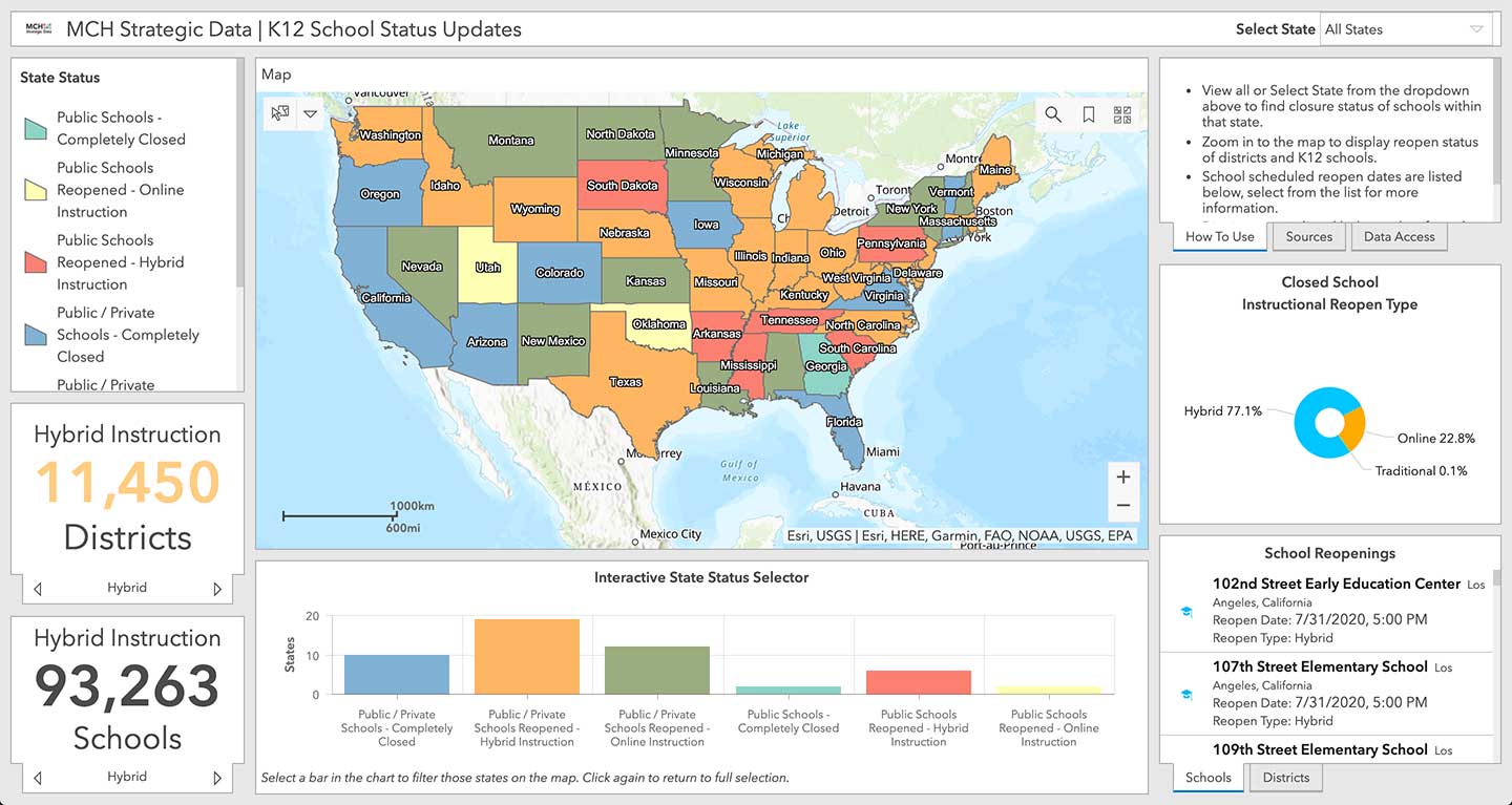
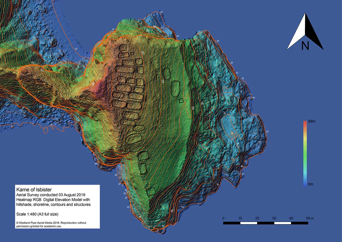
    Location intelligence company Esri will be making data layers available on U.S. school closures during the COVID-19 pandemic, through a new partnership with MCH Strategic Data.

    To help educational organizations as well as families across the nation better understand the situation in their communities, Esri and MCH have made school closure data accessible from a public dashboard.

    Information on K-12 public and private schools include whether they are closed, plans for reopening school buildings, and the type of instruction they are offering during closures due to the epidemic.

    MCH Strategic Data compiles and provides institutional information for the education, healthcare, government, and religious sectors.

    “These datasets are useful for governments, school officials, and businesses providing leadership, resources, and community programs during the COVID-19 response,” said Ryan Lanclos, Esri director of public safety solutions. “But of utmost importance, this is a source of critical information for the community. It provides transparent and useful information that can help families develop a personal plan when they are feeling their most vulnerable.”

    “Our customers depend on us to provide insight to the school market so they can respond effectively and appropriately during this challenging time,” said Kelly Holder, MCH chief information officer. “Our ability to rapidly compile and normalize changing data against our comprehensive U.S. database provides timely insight during an important time in the school planning cycle. This free map and database puts information into the hands of organizations who want to help schools and families now and in the coming months.”

    As the COVID-19 outbreak has escalated rapidly across the globe, and with municipalities struggling to respond, MCH and Esri have built out additional resources like the MCH School Status Updates to help organizations quickly visualize and understand the current situation, as well as identify potential community risk areas when schools begin to open back up, and estimate the capacity needed to respond.

    The Esri COVID-19 GIS Hub provides much of this essential data, along with case locations and social vulnerability, that communities and health organizations can use to inform their response.

    For more information on Esri’s disaster relief support, visit esri.com/disaster.

    Screenshot: Esri, USGS, MCH
    Screenshot: Esri, USGS, MCH
  • Georgia county provides grocery store app for residents

    Georgia county provides grocery store app for residents

    Screenshot: Cobb County
    Screenshot: Cobb County

    Cobb County, Georgia, is providing its residents with an app that tracks what grocery stores are stocking which essential goods, such as paper products, cleaning items and fresh produce.

    The Cobb COVID-19 Grocery Stores and Inventory app gathers input from users, and the data is posted anonymously. Stores can be sorted by distance, senior hours and crowds. Cobb County is a suburb of Atlanta.

    The Cobb County Geographic Information System (GIS) department created the app using Esri ArcGIS.

  • NavVis IndoorViewer 2.6 enables measurement based on point clouds

    Logo: NavVis

    Enables building stakeholders to take accurate measurements based on point clouds

    The latest release of the NavVis IndoorViewer 3D building visualization software features a new tool that lets building stakeholders take highly accurate measurements based on point clouds in the realistic 360° image view.

    NavVis, global provider of indoor spatial intelligence technology and enterprise solutions, announces the release of NavVis IndoorViewer 2.6. This major software release includes a new measurement tool that lets users take highly accurate measurements based on point clouds in realistic browser-based digital buildings.

    This release also makes additional features available to structured e57 point cloud files, including automatically generating highly detailed floor plans and routing.

    NavVis IndoorViewer is a popular deliverable among building stakeholders without the technical expertise to work with point clouds and modeling software, thanks to the realistic digital buildings and intuitive interface.

    One of the features that has proven to be useful among users across multiple industries is the measurement tool. It enables users to take measurements remotely on any device, saving time otherwise spent traveling to the site.

    The release of version 2.6 of NavVis IndoorViewer marks a major advance in the accuracy of virtual measurement tools. The tool has been redesigned to overcome two of the biggest problems with virtual measurement tools – accuracy and usability.

    On the one hand, point cloud measurements are quite accurate. But often these software tools are not accessible or even usable for a wide range of building stakeholders who lack the expertise in working with point clouds. If, on the other hand, the tool uses images or even meshes, which are much more user-friendly than point clouds, the tools are usually not reliable enough to produce accurate results.

    The new measurement tool in NavVis IndoorViewer combines the best of both worlds, thanks to a patent-pending magnifying feature that appears when taking measurements in the realistic 360° view. The magnifying feature reveals the exact section of the point cloud behind the image and lets users pick the point cloud point as the basis for a measurement while benefiting from the intuitive interface of the fully immersive walkthrough.

    “When redesigning the measurement tool in NavVis IndoorViewer, we wanted to make sure that a wide range of stakeholders in every industry that works with built environments could benefit from the accuracy of point clouds when taking virtual measurements,” said Georg Schroth, NavVis CTO. “We are confident that the new magnifying feature in NavVis IndoorViewer achieves our goal. Now even stakeholders that are unfamiliar with point clouds have an easy, intuitive way to take measurements based on this highly accurate real world data.”

    In addition to making strides in the accuracy of remote measurements, the interface of the tool has also been fully redesigned. This includes a new slider function that lets users view the 2D floor plan and 3D walkthrough side-by-side or move from one view to the other.

    The dual view provides an overview of the entire building so that users can easily locate an asset or area while also viewing the location in the realistic 360° view. The fully immersive walkthrough makes it possible to virtually move through the area being measured or inspect the asset, as if the user were on site. Measurements being taken show up in both views.

    The release of NavVis IndoorViewer 2.6 also introduces new feature support for e57 point cloud files captured by static scanners. Previous NavVis IndoorViewer releases have included a popular feature that lets laser scanning professionals upload structured e57 point cloud files and automatically generate realistic, fully immersive 360° walkthroughs that can be published and shared with clients as a web-based link.

    With the release of NavVis IndoorViewer 2.6, two popular features that were previously only compatible with scan data captured by NavVis hardware are now available for point clouds uploaded as structured e57 files. The first is the generation of a navigation graph, which makes it possible to turn static scans into a fully immersive indoor routing tool. The second is the automatic generation of highly detailed floor plans. Now point cloud files uploaded as structured e57 files can be turned into digital floor plans in a few clicks.

    Version 2.6 of NavVis IndoorViewer is now available. Register for a free trial.

  • 2020 US Census Data now available in Maptitude

    2020 US Census Data now available in Maptitude

    Image: Caliper
    Image: Caliper

    The Maptitude 2020 U.S. Census Blocks Groups data is now available for the entire United States, according to software provider Caliper.

    The small-area Census Summary Level is packed with neighborhood information essential for making accurate geography-based decisions. Maptitude users can explore locations by income, income growth, daytime population, age, race, gender, ethnicity, buying power, occupation, employment status, housing characteristics, citizenship counts and more.

    The wealth of data can be leveraged by data scientists and market research analysts using Maptitude mapping software, a comprehensive application for data exploration.

    The 2020 Block Groups are priced at US$250 on the Caliper Store, and are also available as shapefile, KML, KMZ or GeoJSON for an additional fee. If you have any questions about Maptitude or data availability contact the Maptitude team.

  • InnerSpace location platform supports public safety, COVID-19 response

    InnerSpace location platform supports public safety, COVID-19 response

    Photo: Kachura Oleg / iStock / Getty Images Plus / Getty Images
    Photo: Kachura Oleg /iStock / Getty Images Plus/ Getty Images

    Indoor location platform provides municipalities with emergency response and public safety solutions on existing Wi-Fi networks

    InnerSpace, a Toronto-based company, is offering its Wi-Fi-based indoor location intelligence platform to support all levels of government. The platform analyzes patterns and movement in public spaces using existing Wi-Fi networks.

    The platform is suitable for understanding the movement of people inside public spaces and can support emergency response strategies, social distancing programs and help smart cities implement effective security and public safety measures.

    “In response to the global COVID-19 pandemic, we have accelerated the delivery of our public safety solution inFORCE,” said James Wu, CEO, InnerSpace. “Our platform processes RSSI [received signal strength indication] data in real time and returns the industry’s most accurate location data available today. By using public Wi-Fi access points, municipalities have a way to quickly roll out new solutions at city-wide scale.”

    InnerSpace inFORCE was selected in a competitive process by the U.S. Department of Homeland Security, for its ability to use Wi-Fi to locate citizens and track emergency responders in an active shooter scenario.

    The same platform can be used in a wide variety of emergency situations such as the current COVID-19 pandemic. In addition to the company’s tracking capabilities, it’s analytics dashboard gives public safety offices an unprecedented view into how people leverage public spaces.

    “In times of emergency, it is reasonable to prioritize safety and public health to minimize the loss of human life,” said Cerys Goodall, president and COO, InnerSpace. “By providing municipalities with a system that can deliver line-of-sight into how people move in public spaces, we can inform response strategies, improve rescue efforts, and create an infrastructure to support better outcomes.”

    InnerSpace inFORCE ingests RSSI data and returns accurate anonymous indoor locations. The information can be connected directly into emergency response communications systems, building management and security systems, or analyzed by InnerSpace to identify critical patterns and trends in people’s movements.

  • Gladiator Technologies introduces small, high-performance GNSS/INS

    Gladiator Technologies introduces small, high-performance GNSS/INS

    Gladiator Technologies’ low-noise inertial sensor and systems technology coupled with Velox high-speed processing are now integrated with a 72-channel GNSS receiver to provide compact GNSS/inertial navigation systems (INS) for accurate position, velocity and attitude.

    Landmark 60 GNSS/INS. (Photo: Gladiator Technologies)
    Landmark 60 GNSS/INS. (Photo: Gladiator Technologies)

    The feature set was carefully selected to suit several positioning, navigation and timing (PNT) applications including flight control, navigation and stabilization for imaging, platforms and antennas.

    The high-performance LandMark 60 INS/GPS and compact LandMark 005 INS/GPS both feature advanced sensor-fusion technology, combining GNSS position data with Gladiator Technologies’ low-noise, high output inertial sensors as well as barometric pressure and magnetometers.

    Both products feature Gladiator Technologies’ proprietary Velox  processing technology and extended Kalman filter (EKF), enabling precision position information during short-term GPS outages.

    Velox  Technology combined with the new EKF enable the LandMark  INS/GPS products to have accuracy of less than 2 nautical miles per hour during short-term GPS outages.

    Landmark 005 GNSS/INS. (Photo: Gladiator Technologies)
    Landmark 005 GNSS/INS. (Photo: Gladiator Technologies)

    The LandMark 60 INS/GPS is the top performing unit with +/- 0.3° heading accuracy and pitch/roll angle measurements of 0.1°. It is also available with an option for a real-time kinematic (RTK) GPS receiver.

    The small and robust LandMark 005 INS/GPS is less than 35 square centimeters and is suitable for space-constrained applications that require a high standard of INS/GPS performance.

    “Our low-noise sensor inputs to the EKF are enhanced by an adaptive estimation algorithm,” said Lee Dunbar, chief software architect. “This, along with extended precision for the nonlinear solution integrator, maximizes the accuracy of position, velocity and attitude. Customer configurable EKF parameters are present to allow optimization for their applications.”

    “Leveraging our inertial capability into a complete INS/GPS package was a natural progression for our product line,” said Eric Yates, Gladiator Technologies’ new business development manager. “With the LandMark 005 INS/GPS and LandMark 60 INS/GPS we’re offering an exceptional MEMS-based INS/GPS that fits in the palm of your hand.”

    A development kit is available for set-up, configuration and data collection.

  • Esri to provide mapping resources to WHO Member States

    Esri to provide mapping resources to WHO Member States

    Advanced geospatial technology offered to global communities during COVID-19 crisisPhoto:

    Global mapping company Esri will provide a COVID-19 Response Package for the World Health Organization (WHO) Ministries of Health and Global Outbreak Alert and Response Network (GOARN) partners.

    The package will enable these organizations to have access to Esri’s geospatial platform and tools that can be used for reporting and analysis of cases and deaths, public health and response activities at the national level, in addition to managing testing sites, community activities and impact, and much more at the local level.

    “The intent of our partnership with WHO is about providing technology and capacity building to all the national and local Ministries of Health,” said Jack Dangermond, Esri founder and president. “Having integrated geospatial data and analytics is important to a comprehensive and dynamic response to the rapidly changing situation related to COVID-19. This is particularly true in low resource countries.”

    This contribution to the global COVID-19 response will support the digital transformation of global health information systems through mapping and analytics technology. Esri’s geospatial software helps organizations understand complex and vast amounts of data by placing it in a geographic context with sophisticated analysis capabilities such as artificial intelligence (AI).

    “While our company has always supported the efforts of governments and NGO’s when facing crises, the COVID-19 pandemic is different and requires a rapid and global response,” said Dangermond. “Our work with WHO is about helping MoHs around the world in equipping and assisting communities with our technology. We strongly believe these efforts will help combat its spread.”

    Ministry of Health or GOARN partners can request their COVID-19 Response Package here.

    Software access for students

    Esri is also providing free access to its ArcGIS platform and learning resources through its Learn.ArcGIS.com website to support college and university students who no longer have access to campus computer labs during the COVID-19 outbreak.

    Students will receive access to ArcGIS Online and over 20 apps including ArcGIS Pro, along with a library of lessons to continue their learning and complete courses. Access is available globally to students ages 18 and over.

  • European GNSS Agency provides list of COVID-19 apps

    European GNSS Agency provides list of COVID-19 apps

    Photo: AntonioGuillem/iStock / Getty Images Plus/Getty Images
    Photo: AntonioGuillem/iStock / Getty Images Plus/Getty Images

    The European GNSS Agency, based in Prague, is providing on its website a list of location-enabled applications that it considers potentially useful in response to the COVID-19 pandemic.

    The applications range from those helping public authorities understand the dynamics of the outbreak to supporting citizens in their everyday lives by checking supermarket lines.

    The apps are sorted into four categories:

    • Tracking the COVID-19 pandemic
    • Queue management
    • Response management
    • Information dissemination

    If you are an application developer and you want to add your app to the list, contact [email protected].

  • Phase One launches 280-megapixel camera with Applanix GNSS

    Phase One launches 280-megapixel camera with Applanix GNSS

    Photo: Phase One Industrial
    Photo: Phase One Industrial

    Phase One Industrial has launched a 280-megapixel aerial photogrammetric system, with an image coverage width of more than 20,000 pixels.

    The large format enables unprecedented high-quality aerial survey productivity, the company said. Compact and lightweight, the new aerial mapping solution can reduce operating costs and produce better returns on investment than today’s traditional large format systems.

    The Phase One Industrial 280MP Aerial Solution consists of an iXM-RS 280F large format camera, Applanix GNSS/IMU receiver (POS AV series), Somag gyro-stabilized mount (DSM 400), Phase One iX Controller and iX Flight Management software.

    The system is a large format camera system that easily integrates with the DSM400 gyro-stabilized mount, creating a compact and lightweight system for use in a wide range of aircraft.

    At the system’s heart is the iXM-RS 280F, a dual-lens metric camera with 90mm lenses for capturing RGB information, providing precision imaging. Adding a near infrared (NIR) camera generates a 4-band configuration, most useful in agriculture, forestry and pipeline monitoring.

    The iXM-RS 280F camera generates a central projection image from two 150MP nadir images with equal ground resolution. The cameras’ backside illuminated CMOS sensor supports very high dynamic range at 83dB. Its high light sensitivity provides superb image quality in challenging low light conditions, enabling operators to take advantage of more flight hours per day and more flight days per year.

    “Our 280MP Aerial Solution is a bold and innovative approach to solving customers’ demands for affordable and reliable aerial mapping performance,” said Dov Kalinski, general manager, Phase One Industrial. “Previously, opportunities in the aerial mapping business were restricted due to high cost of equipment and limited aircraft options. While pioneering superior image quality, Phase One Industrial is creating more profitable possibilities in this exciting and important market.”

  • Analytics and drones detect trash in San Francisco Bay

    Kinetica simplifies active analytics with Kinetica Cloud

    Kinetica, provider of the Kinetica Active Analytics Platform, has unveiled the Kinetica Cloud. Enterprises can use the full capabilities of the Kinetica platform in an optimal cloud environment, which includes historical data analytics, streaming data analytics, location intelligence and machine learning.

    Kinetica Cloud was adopted by the San Francisco Estuary Institute (SFEI), which used the platform to detect trash in San Francisco Bay.

    “The San Francisco Estuary Institute uses Kinetica Cloud for high-performance computing and to manage thousands of high-definition images of the landscape, which our machine learning algorithm studies to detect trash,” said Tony Hale, program director for Environmental Informatics, SFEI.

    Photo: Thinkstock/Stockbyte/Getty Images
    Photo: Thinkstock/Stockbyte/Getty Images

    “With this more systematic way of monitoring when trash enters the landscape in uncontrolled ways, cities and governments that really care about the environment gain a remarkable resource to help them very quickly and effectively make decisions,” Hale said.

    “With Kinetica Cloud, organizations across industries gain invaluable business flexibility and agility to direct their mission-critical initiatives,” said Paul Appleby, CEO, Kinetica. “Kinetica Cloud gives customers the ultimate flexibility in a hybrid, multi-cloud environment, empowering them to determine where it is optimal to deploy Kinetica.”

    Organizations can use the Kinetica Active Analytics Platform on Kinetica Cloud without the complexity and wait times of deploying hardware systems and software.

    “As customers adopt active analytics, they want to start their initiatives quickly to gain insight from their data,” said Karan Batta, senior director, Product Management, Oracle Cloud Infrastructure. “We are very pleased that Kinetica Cloud is available for Oracle Cloud, allowing organizations to shift their focus away from infrastructure and towards bringing smart analytical applications to market faster.”

  • iXBlue launches range of FOG-based INS for mobile mapping

    iXBlue launches range of FOG-based INS for mobile mapping

    The compact Atlans A3 INS. (Photo: iXBlue)
    The compact Atlans A3 INS. (Photo: iXBlue)

    iXBlue has launched a new range of FOG-based inertial navigation system (INS) dedicated to land and air mobile mapping applications, the Atlans Series. iXBlue is high-tech company specializing in the design and manufacturing of advanced navigation and georeferencing solutions.

    Based on iXBlue’s fiber-optic gyroscope (FOG) technology, the Atlans Series is a scalable range of north-seeking and north-keeping inertial navigation systems. They provide FOG performance to the full spectrum of land and air mobile-mapping applications and offer highly accurate positioning (up to 0.01 meter) in all conditions, including within GNSS-denied environments such as urban canyons, mountainous or forests areas.

    “Our existing high-grade Atlans A7 INS had already been adopted as the preferred georeferencing solution by leading U.S. companies operating in the pavement condition survey industry,” explained Marine Slingue, vice president, iXBlue. “Having identified the high potential of our technology for other land and mobile mapping applications, we decided to develop a complete range of scalable INS that each meet the specific requirements of every applications. With our new Atlans Series INS, we are now bringing the unrivaled georeferencing accuracy performance offered by the FOG technology to all land and air mapping applications, enabling robust and uninterrupted data-acquisition operations.”

    Quick and simple to install on all platforms, the new Atlans Series INS offers efficient “set-and-forget” operations for a wide range of land and air applications including asset inventory, pavement condition survey, vehicle automation, HD mapping, automotive testing, ground-truth, airborne surveys (UAVs, planes, helicopters), as well as precision pointing.

  • Exploring Shetland’s uninhabited Kame of Isbister with GNSS and UAV

    Exploring Shetland’s uninhabited Kame of Isbister with GNSS and UAV

    The mysterious and fascinating Kame of Isbister is situated in Shetland’s north mainland near the North Roe. The location has been studied several times, including by the Extreme Archaeology TV series in 2003. The uninhabited grassland continues to attract explorers because of a series of secret structures.

    Those structures are hidden on the sea-faced slope and can’t be seen from the land nearby. One theory posits that it’s an eremitical monastery settlement. The late Pictish/early Medieval site is hard to access — and that’s where drones coupled with GNSS receivers helped explorers.

    In 2019, Shetland Flyer Aerial Media in collaboration with Shetland College UHI and the Institute for Northern Studies explored the site. Their goals: create a 3D model of the headland as well as an orthomosaic and digital terrain model to identify and map the monastery structures.

    Because the site is hard to access, the team decided to use the DJI Phantom 4 RTK SUA (drone and base) with two flights. One flight captured both the Kame and a piece of the mainland for context, with a ground sample distance (GSD) of 2.4 centimeters/pixel (cm/px). The second flight was on a shorter GSD of 1.9 cm/px to capture detailed pictures of the cape and structures.

    Before the survey, the team used the Emlid Reach RS+ real-time kinematic (RTK) receiver to identify and establish the base mark for the drone on the mainland nearby.

    Ground control point locations. (Image: Emlid)
    Ground control point locations. (Image: Emlid)

    The base mark was then post-processed using data from the OS Net reference station in Lerwick. Considering the long baseline (52 kilometers), it took the team four hours to observe the mark with Reach RS+. Later, when the archaeologists managed to climb the headland, the RTK receiver collected several noticeable control points.

    Creating the 3D model. During both flights, the drone’s base was sending corrections in RTK mode. In post-processing, horizontal accuracy of the processed map initially was within 10 cm with vertical at 15 cm. After adding the control points gathered with the RTK receiver, the error was reduced to 6.5 cm, significantly increasing the accuracy of the model.

    The team performed the GIS processing in QGIS 3.4 LTR.

    Screenshot: Emlid
    Screenshot: Emlid

    Despite the long grass, they managed to distinguish each structure out of the orthomosaic using the 32-bit floating point raster digital elevation model (DEM). The team created a basic map with structures and contours, a hillshade version and a heat map.

    With proper preparation and setup, a GNSS RTK receiver with a drone can gather enough high-accuracy data to create accurate models and maps of an archaeological site — even if it’s hard to reach.

    Shoreline contours and structures. (Image: Emlid)
    Shoreline contours and structures. (Image: Emlid)
    Shoreline contours and structures with hillshade. (Image: Emlid)
    Shoreline contours and structures with hillshade. (Image: Emlid)
    3D model: The heatmap of the Kame of Isbister shows elevations and the archaeological site. (Image: Emlid)
    3D model: The heatmap of the Kame of Isbister shows elevations and the archaeological site. (Image: Emlid)