According to a study by Future Market Insights, the contact tracing applications market is set to grow 15% CAGR through 2030.
“Functional advantages of contact tracing applications include superior data quality, easier tracking and monitoring of larger numbers of people in a time effective manner, the ability of real time analysis, and the significant improvements to management and coordination of manual contact tracing teams,” said a lead analyst at Future Market Insights.
Key highlights noted in the report include that the market for contact tracking applications is projected to display exponential growth through the forecast period on the back of the ongoing coronavirus crisis; decentralized, Bluetooth-based applications are likely to gain strong traction as a result of data privacy concerns; Android platforms are likely to contribute significantly to adoption owing through higher penetration of associated smartphone models; and Europe is expected to be a prominent market, with East Asia showing lucrative growth prospects on the back of mandatory use in China.
COVID-19’s impact on the contact tracing applications market
The COVID-19 pandemic has played a role in the contact tracking application market’s growth: according to the study, the pandemic has been the primary driver for the development, deployment and adoption of contact tracing applications. Government initiatives toward social distancing and patient tracking has influenced the industry’s growth, as well.
The study also has projected an increase in disease control applications as a result of the COVID-19 pandemic.
According to the study, countries such as Ireland and South Korea have been able to use contact tracing applications to gain promising results towards breaking chains of coronavirus patients, limiting the risks of community transmission.
Despite the market’s growth, demand for these applications has been limited to countries with high rates of smartphone penetration. In addition, ethical problems in terms of transparency, privacy and accountability have restrained adoption during this period.
“However, prospects for contact tracing applications remain positive for the post-pandemic era, owing to potential for use in controlling other infectious disease outbreaks worldwide, albeit at a smaller scale,” the report said.
This report analyzed various strategies employed by major companies operating in the contact tracing applications market. Some of the participants operating in the contact tracing applications market include IBM, Oracle, Microsoft, Apple, T-Systems, SAP SE, Salesforce.com, Siemens AG and ServiceNow.
GPS technology is doing far more than helping us navigate or receive accurate time. It is now being used to fight the spread of the global COVID-19 pandemic.
Global navigation satellite systems are being used to collect big data on travel and contact, but they are also being used in more unconventional ways: for example, quarantine enforcement and sanitation technology.
Read on to learn about a few recent developments in the world of GNSS/GPS that are bolstering the battle against the novel coronavirus.
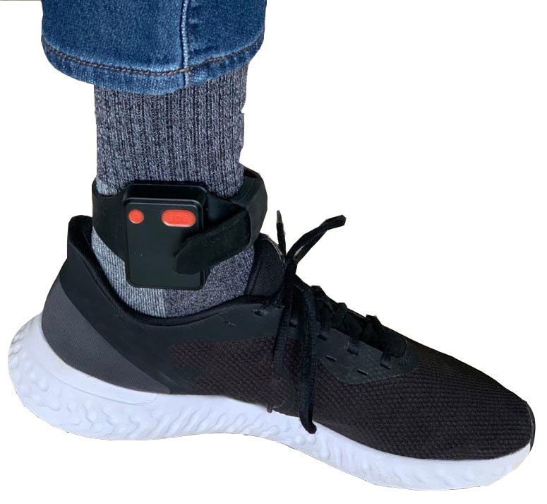
Electronic monitoring enforces quarantine
There is a surge of applying ankle monitors to track sick individuals and deter them from spreading the virus further. According to BloombergBusinessweek, one business is thriving because of it: providers of electronic ankle monitors.
Kentucky courts are requiring GPS ankle monitors for people who test positive for COVID-19 and refuse to self-quarantine. Kentucky couple Elizabeth and Isaiah Linscott were two of a growing number of people placed under house arrest after Elizabeth tested positive for COVID-19 and denied signing the Self-isolation and Controlled Movement Agreed Order, a health department document promising she would stay home.
Photo: Regulus Cyber
Elizabeth told Louisville television station WAVE 3 News that she did not sign because she disagreed with the wording of the document. She said that she was concerned about having to contact the health department before traveling, even in the case of an emergency.
“My part was if I have to go to the ER, if I have to go to the hospital, I’m not going to wait to get the approval to go,” she said.
A few days after Elizabeth refused to sign the paperwork, her husband opened their door to an entourage of law enforcement officers serving them with a Health Department order to wear ankle monitors.
“I open up the door, and there’s like eight different people, five different cars, and I’m like ‘what the heck’s going on?’ This guy’s in a suit with a mask. It’s the Health Department guy, and they have three papers for us. For me, her and my daughter,” Isaiah said.
The Linville family is now confined to a 200-foot radius. If they leave their designated quarantine area, their ankle monitors will alert law enforcement.
Alternative to prison
The number of people on house arrest in the United States and across the world has surged as corrections departments struggle to slow the spread of the coronavirus within prisons. An estimated 25 to 30 percent more people are wearing ankle monitors in comparison with a few months ago, according to Bloomberg Businessweek. The U.S. Federal Bureau of Prisons reported a 160 percent increase in home confinement from late March to July. European corrections departments have similarly put thousands of inmates on house arrest in the last few months.
“Demand has spiked everywhere,” BI Inc. monitoring equipment executive Robert Murnock said to Bloomberg. “We’re getting calls from different jurisdictions and other countries we’ve never worked with.”
Efforts to reduce crowding in prisons mean that the electronic monitoring industry is one of very few industries benefiting financially from the coronavirus pandemic.
“Coronavirus gives electronic monitoring companies an opportunity like they’ve never had before to expand,” parole reform expert James Kilgore said.
On Aug. 3, Singapore announced the rollout of electronic tracking devices to enforce quarantine. Travelers will be required to wear GPS and Bluetooth-powered tracking devices that notify authorities if quarantine is broken or the device is tampered with. The rule went into effect on Aug. 11 and applies to all incoming travelers — resident or nonresident — over the age of 12.
On Aug. 20, the premier of Western Australia, Mark McGowan , said his government could soon force people in hotel quarantine to wear electronic monitoring equipment if they are deemed a risk. “If we identify people who are potential flight risks or who might have a criminal history, we are looking at applying monitoring bracelets to them,” he said.
An estimated 25 percent to 30 percent more prisoners are wearing bracelets now compared to the pre-outbreak period. In the U.S., the Federal Bureau of Prisons has placed about 4,600 inmates in home confinement, a 160 percent increase since the end of March.
“Demand has spiked everywhere,” said Robert Murnock, vice president for partnership development at BI Inc., a provider of EM technology.
The emergency shift to electronic monitoring spurred by COVID-19 may foretell a long-term shift toward use as an alternative to prison time, reducing clutter and the risk of the virus spreading among inmates.
Photo: LeoPatrizi/E+/Getty Images
Contact tracing via mobile phones
Israel is using covert mobile phone data to track the spread of COVID-19. On July 1, the Knesset approved a bill temporarily reauthorizing mass surveillance of coronavirus-infected citizens by the Shin Bet, Israel’s internal security service. The original program lasted from mid-March to June 9.
The contact-tracing program works like this. When a patient is diagnosed with COVID-19, the Israeli Health Ministry provides their personal information — including their mobile number — to the Shin Bet. The Shin Bet then consults a classified database of every person who uses Israeli telecom services to determine who came into contact with the infected individual for more than 15 minutes at a time. After the Shin Bet sends information back to the Health Ministry, the Health Ministry notifies those people via text and tells them to self-quarantine.
The Shin Bet’s newfound role in public health enforcement is quite different from its usual focus. Former Shin Bet agents say the COVID-19 mobile phone tracking technology was originally developed as a counterterrorism measure, and the tracking system being used on Israeli civilians is almost identical to that used for suspected terrorists.
“It’s the same system, the same methods,” retired Shin Bet agent Arik Brabbing said to BBC. “We know that someone was here in the park. We can get from the [mobile phone] company all the details about the hour, the place, exactly the place… and we can understand who else was around.”
Supporters of the mass surveillance program, including Prime Minister Benjamin Netanyahu, argue that reduced privacy is necessary to curb the spread of the virus. However, the Israeli government has come under fire by opponents who claim that the program is intrusive and undemocratic.
Israel’s contact tracing procedures are more secretive than those of South Korea and Taiwan, other countries that mandate central mass surveillance. South Korea and Taiwan both enforce quarantines with mobile-phone tracking, and both have built publicly available COVID-19 data platforms.
The South Korean government has disseminated detailed — but anonymized — information about COVID-19 carriers, including their travel routes and treatment facilities. Citizens broadly support these measures — a testament to collectivism in Korean culture.
Civic engagement and enthusiasm for fighting the pandemic is also remarkable in Taiwan, where the public has been collaborating with the government on a town hall-style website called vTaiwan. Citizen-led initiatives, like a GPS-powered tool for tracking face mask supplies, have been applied nationwide.
Meanwhile in Europe, eight major telecom companies, including Vodafone and Orange, have been supplying anonymized metadata to the European Commission to model and predict the spread of the virus. In the United States, the Centers for Disease Control and Prevention is soliciting GPS data from mobile advertising companies rather than carriers themselves.
The two tech giants, Apple and Google, made it easier for health agencies to join its coronavirus exposure notification system, creating a new built-in app within iOS and Android. The app provides real-time notification to users when they are exposed to a sick person.
Virus-killing robots may roam the streets
GPS-based robots, drones and autonomous cars are being deployed to sanitize outdoor spaces, transport medical equipment, and announce safety information to the public.
Robots began rolling around the streets of Wuhan, the original epicenter of the coronavirus outbreak, as early as January. China was the first to deploy robots of this type, but India, Spain, France and other countries have followed in their footsteps. In addition to the chemical-spray approach, some companies are pioneering mobile disinfection robots armed with large ultraviolet-C germicidal lights.
Apollo, the autonomous vehicle company of multinational internet giant Baidu, has partnered with Chinese self-driving startup Neolix to transport food and supplies to Beijing Haidian Hospital. Every morning at 10:30 a.m, an unmanned car delivers meals to about 100 frontline workers. The process eliminates direct contact, protecting the safety of food service workers, hospital staff, and patients.
Zhangjiang Artificial Intelligence Island
A fleet of Apollo and Neolix’s unmanned cars is also responsible for disinfecting all roads on Zhangjiang Artificial Intelligence Island, an 100,000-square-meter industrial complex in Shanghai. The vehicles are loaded with up to 160 liters of spray disinfectant and can cover the island’s entire road system in about half an hour.
The vehicles at Zhangjiang AI double as nighttime surveillance bots. They patrol the island and make sure that guests are adhering to coronavirus protocols, alerting security personnel if they note suspicious activity.
In addition to using drones to spray disinfectant, South Korea’s government has leveraged the technology for public announcements. On July 4, 300 drones lit the sky above Seoul in a show of appreciation for frontline workers. The drones executed a 10-minute synchronized show that included images of face masks, hand washing, and social distancing.
Summary
As COVID-19 continues to ravage the globe, governments rely on GPS to track the virus, contain it, and fight against it. The battle against coronavirus is still being waged on a global scale, utilizing GPS as a weapon along with many other existing technologies.
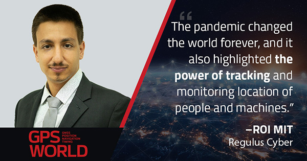
The pandemic changed the world forever, and it also highlighted the power of tracking and monitoring location of people and machines. It is another testament to the immense reliance on GPS technology in our modern world.
The increased deployment of these technologies necessitates increased security measures, especially when public health is on the line. Regulus Cyber offers GPS Cybersecurity software. To read more about it, visit www.regulus.com.
The European GNSS Agency (GSA) has launched the MyGalileoSolution competition. The contest is targeting European innovators and entrepreneurs ready to develop location-based solutions, such as mobile applications, wearable-based solutions, asset management and tracking solutions, or robotics, leveraging Galileo as a source of positioning, navigation and/or timing. A wide participation from all Member States is expected.
GSA has a successful track record in supporting and boosting GNSS-based innovative applications. For years, the agency has been leading several research and innovation initiatives such as the Galileo Masters, Horizon 2020 projects, and more recently European competitions like the 2019 MyGalileoApp and Hackathons across Europe and beyond.
Two tracks for 56 prizes
With a prize pool of almost € 1.5 million, MyGalileoSolution is the largest competition ever organized by the GSA. It consists of two independent and parallel tracks, each one with a list of goals and deliverables.
Track 1 , From Idea to Prototype, aims to develop a beta version of an application or a prototype of a solution implementing an idea, reaching a minimum of 50% of its functionality.
Track 2, From Prototype to Product, aims to develop a fully functional solution ready to be commercialised starting from a beta version of an application or a prototype.
Participants are expected to leverage Galileo’s robust positioning and accurate timing and synchronization capabilities, showing how it can enable the development of the next generation of applications and services across a wide range of areas. In this competition the GSA is challenging innovators in four different areas: Crisis & Emergency Response, Smart Transport for Green Deal, Solution for Digital Age, and Cybersecurity.
Galileo for location-based services
With more than 1.5 billion Galileo-enabled smartphones and more than 51 million GNSS-enabled wearable devices in the market, location-based services (LBS) are booming. Accurate positioning and timing are at the heart of the growth and evolution of LBS, in addition the access to Android GNSS raw measurements has allowed for the creation of advanced GNSS positioning algorithms that enable the development of more ambitious smartphone-based applications.
‘’Galileo has set the trend for dual-frequency chipsets, which provide better accuracy and are more resistant to multipath in urban environments,” said Pascal Claudel, GSA acting executive director. “We are looking forward to seeing innovators launching their disruptive GNSS solutions and turning them into real businesses, hence leading to European growth, competitiveness and sustainability. There is ‘space’ for all types of innovation and we expect the participation of all Member States.”
“Competitions like MyGalileoSolution are a great opportunity to quickly move from idea to market,” said Francesco Fiorito, leader of Argeo, the winning team of the 2019 MyGalileoApp competition. “It is a confidence boost for young entrepreneurs and their capacity to grow and generate new solutions and business,” Claudel concluded.
Deadlines and more information
The deadline for submission for both categories is Sept. 30. Projects will be evaluated in terms of their innovative nature, market potential, feasibility and Galileo relevance by a panel of GSA experts.
The extended-range data call milestone was completed in Janesville, Wisconsin, over a more than 5-km distance with speeds greater than 100 Mbps. According to the companies, the achievement redefines the perception of 5G mmWave spectrum as an urban- or high-density-only deployment technology and offers new opportunities to use current infrastructure for broader 5G coverage.
This milestone demonstrates that mmWave can help close the “connectivity divide” and expand broadband services throughout rural, suburban, and urban communities. This breakthrough gives communications service providers a cost effective way to expand their coverage and deliver 5G experience to communities that previously were not serviced or may have lacked a reliable connection.
It will also open the door for new use cases, which will bring 5G benefits to homes and business everywhere, from urban to rural communities. For example, Fixed Wireless Access (FWA) installations can provide a cost-effective way to deliver fiber-like internet speeds wirelessly over mmWave to institutions such as schools, hospitals and town halls, and for addressing some of the “last mile” challenges in rural areas. FWA provides the bandwidth required to support high definition streaming services that can improve experiences like remote education and remote healthcare in suburban and rural environments.
Mike Irizarry, chief technology officer, U.S. Cellular, said, “This is a key strategic milestone in our 5G evolution. Expanding 5G mmWave coverage enables us to offer high-speed broadband services to consumers and businesses in rural areas and underserved communities and reinforces our commitment to technological leadership for rural America. It is a concrete example where U.S. Cellular is driving innovation leadership in extended range technology from Ericsson and promoting the high-power device ecosystem enabled by Qualcomm Technologies.”
“This major milestone of using mmWave for an extended-range 5G data transfer is paving the way to implement fixed broadband services for broad coverage in urban, suburban and rural environments,” said Alejandro Holcman, senior vice president, engineering, Qualcomm Technologies. “With the introduction of the Qualcomm QTM527 mmWave antenna module as part of the Qualcomm Snapdragon X55 5G Modem-RF System, we are empowering operators and OEMs to offer high-performance, extended-range multi-gigabit 5G broadband to their customers — which is both flexible and cost-effective, as they can leverage existing 5G network infrastructure.”
Per Narvinger, head of product area networks, Ericsson, said, “Ericsson is constantly pushing the boundaries of 5G technology to bring its benefits everywhere across the globe. Ericsson has a long and successful track record in extending coverage across generations of mobile technologies. Working with our partners, Ericsson has now demonstrated the commercial viability of long-range 5G radio capability for mmWave spectrum.”
The milestone was achieved by applying extended-range software to commercial Ericsson hardware — including AIR5121 and Baseband 6630 — and a 5G CPE device powered by the Snapdragon X55 5G Modem-RF System with the Qualcomm QTM527 mmWave antenna module.
The collaboration will provide designers with a power-efficient, high-accuracy GPS solution for battery-operated devices without the additional cost of a dedicated GNSS chip.
“Today’s advanced navigation systems are facing unique challenges when being implemented in power-constrained IoT devices,” said Ambroise Popper, CEO at Nestwave. “By combining Nestwave’s low-power geolocation software with Synopsys’ efficient ARC IoT Communications IP Subsystem, we can deliver a geolocation solution that offers greater accuracy, lower power consumption, and lower cost compared to existing GNSS solutions.”
Ultra-low bandwith IoT applications
The ARC IoT Communications IP Subsystem is an integrated hardware and software solution that combines Synopsys’ DSP-enhanced ARC EM9D processor, hardware accelerators, dedicated peripherals and RF interface to deliver efficient DSP performance for ultra-low bandwidth IoT applications.
Nestwave’s GNSS solution takes advantage of the ARC EM9D processor’s efficient DSP capabilities and ability to add dedicated hardware accelerators or custom instructions using APEX technology to reduce frequency requirements, giving customers additional performance bandwidth.
The ARC EM9D processor is supported by the MetaWare Toolkit, which includes a rich library of DSP functions, allowing software engineers to rapidly implement algorithms from standard DSP building blocks.
Geolocation for emerging applications
Nestwave has developed an ultra-low power, advanced GNSS solution for use in IoT applications. When integrated with an IoT modem such as NB-IoT, Cat M1, LoRa or Sigfox, the solution offers low-cost geolocation for emerging applications such as asset tracking, smart factories, and smart cities, without the need for an external GNSS chip.
“Emerging IoT applications are demanding geolocation functionality with high-accuracy and ultra-low power consumption,” said John Koeter, senior vice president of marketing and strategy for IP at Synopsys. “The combination of Synopsys’ ARC IoT Communications IP Subsystem with Nestwave’s GNSS technology will help designers significantly improve geolocation performance, reduce frequency requirements and lower overall power consumption for battery-powered IoT applications.”
The European GNSS Agency (GSA), in collaboration with the Council of European Geodetic Surveyors (CLGE), has launched the Geomatics on the Move 2020 competition. The event aims to foster the use of European Union (EU) satellite programs Galileo, EGNOS and Copernicus among students, young professionals, entrepreneurs and small and mid-sized businesses to create innovative geomatics applications and solutions across all over Europe.
Building and expanding on the CLGE Student Contest, which has been held for the past nine years, the new Geomatics on the Move Prize Contest targets applications that integrate the use of additional technologies such as artificial intelligence, machine learning, augmented and virtual reality, as well as supplementary remote sensing data sources like drones, GSA said. Solutions animated through mobile phone applications or other easy-to-use platforms are also accepted.
“This is the ninth year of partnership between the Council of European Geodetic Surveyors and the GSA; over the years we have seen some exciting and innovative solutions emerge that leverage the EU Space Programme to deliver practical solutions for the mapping and surveying community,” said GSA Acting Executive Director Pascal Claudel. “This year, as we recover from this global setback, I look forward to seeing even more novel ideas — from all over the European Union — able to respond to current and future challenges.”
The competition will be organized in two stages. The first phase is an open call for ideas, during which applicants submit posters describing their ideas. The deadline for these submissions is Oct. 16.
The proposals then will be evaluated by the GSA and CLGE, and a maximum of 10 projects will be chosen to present their pitch during the finals. The selected applicants will refine their poster and prepare their pitch, for which technical support and training will be made available.
The official award of the Geomatics on the Move prize contest will take place virtually, during the European Space Week, taking place Dec. 7-11. During this event, finalists will present their solutions to the evaluation board, and winners will be announced on the official contest site.
With an overall prize of €30 000, a set of 10 prizes will be offered in two categories. The first of these categories targets EU space-based traditional geomatics solutions and the second targets integrated geomatics solutions. he first category is looking for solutions in which the main innovation is based on the use of EGNSS, employing traditional equipment such as surveying or GIS grade GNSS receivers for applications such as cadastral, marine and mining surveying or GIS mapping. The integrated geomatics category targets integrated surveying solutions that use Galileo or EGNOS and leverage cutting-edge tools and technologies such as drones, mobile mapping, laser scanners or augmented/,mixed reality, both within geomatics applications or beyond.
Recent GPS World webinars have focused on a variety of proven, resilient technologies to combat GNSS and positioning, navigation and timing (PNT) vulnerabilities in critical infrastructure.
Now a Sept. 17 GPS World webinar focuses on how PNT monitoring can further protect critical systems from these vulnerabilities through continuous monitoring and improvement.
The Orolia-sponsored webinar is free. It is scheduled for 1 p.m. EDT / 10 a.m. PDT / 7 p.m. (1900h) Central European Time. Register here.
Protecting critical infrastructure is now a national priority for the U.S. and allied countries. Similar to cybersecurity for network systems, effective GNSS and PNT protection involves identifying and monitoring weak entry points, knowing where and when an intrusion occurs, and providing data about new threats to help strengthen the system going forward. Its value applies across all critical infrastructure sectors such as telecom, power grids and data centers.
Webinar speakers include:
John Fischer Vice President, Advanced R&D, Orolia
For more than 15 years, Fischer has been part of Orolia where he works with global navigation satellite systems, wireless, positioning navigation and timing, as well as specialized systems for its customers. Prior to joining Orolia, he specialized in wireless telecom as a founding member of two startups: Aria Wireless in 1990 and Clearwire Technologies in 1997. At Clearwire, he served as chief technology officer in creating wireless broadband equipment for internet connectivity. Early in his career, Fischer worked as a systems engineer in radar, EW, and command and control systems at Sierra Research and Comptek Research. He holds master’s and bachelor’s degrees in electrical engineering and computing engineering from the State University of New York at Buffalo.
Tim Frost Strategic Technology Manager, Calnex Solutions
Tim Frost is a specialist in next-generation synchronisation techniques, having worked with Zarlink Semiconductor, Symmetricom and now Calnex Solutions on packet-based synchronisation technologies. He is an active contributor to the ITU-T, and has also contributed to the AVnu Alliance, Small Cell Forum, Metro Ethernet Forum and IETF. He has a BSc. in Electrical and Electronic Engineering from the University of Leeds, and a MSc. in Computer Systems Engineering from the University of Manchester.
Francisco Girela Americas Tech Responsible, Seven Solutions
Francisco Girela is the Americas Tech Responsible at Seven Solutions. He holds a Master’s degree in Telecommunications Engineering from the University of Granada. After some time in the private sector, Francisco joined the Timing Keepers group at the same university as a researcher. During his research, he specialized in ultra-accurate time transfer systems and he focused on the development of the White Rabbit technology. He combines his work for Seven Solutions with his studies for a Ph.D. in Telecommunications Engineering. This combination has provided Francisco with a strong technical background on high-accuracy time synchronization and deep knowledge on timing applications in industrial sectors.
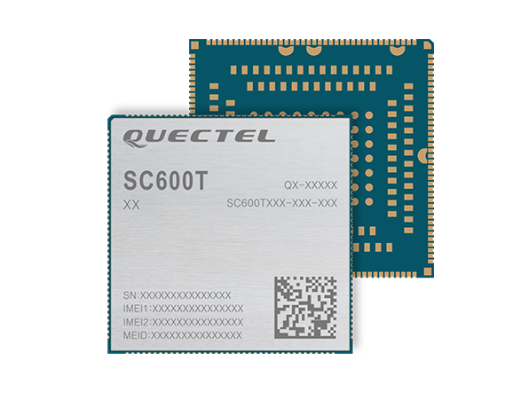
The SC600T-NA and SC600Y-NA are industrial-grade LTE Cat 6 modules with an operational and certified built-in Android 9.0 OS.
The SC600T-NA is based on the Qualcomm Snapdragon MSM8953 and supports Octa-core A53 up to 2.0 GHz, camera 24 MP and video 4K at 30 fps.
The SC600Y-NA adopts the Qualcomm Snapdragon SDM450 and Octa-core A53 up to 1.8 GHz, camera 21 and video 1080 at 60 fps.
A multi-constellation GNSS receiver is available in both modules, which is ideal for applications that require fast and accurate fixes, such as in-car video streaming and live video devices, the company said.
Both modules integrate 2 GB LPDDR3 + 16 GB eMMC flash and support WUXGA display.
With powerful engines, the two modules are fully integrated with Bluetooth, Wi-Fi capability and strong multimedia functions include support for dual LCDs and dual touch panels with independent display and operation. The modules can support a maximum of four cameras with two working simultaneously. Quick Charge 3.0 technology can facilitate various smart devices, including vending machines, smart cash registers, smart delivery machines and more.
Designed for North America, both modules work on FDD-LTE bands B2/B4/B5/B7/B12/B13/B14/B17/B25/ B26/B66/B71, TDD-LTE band B41 and WCDMA bands B2/B4/B5.
“These two modules for North America have passed another industry milestone. They will enable IoT designers, manufacturers and their customers to utilize the latest and leading LTE network technologies from America’s most awarded network,” said Patrick Qian, chairman and CEO of Quectel. “The new generation Cat 6 smart modules are critical for devices to utilize the processing power whenever needed.”
The global LoRaWAN market is projected to reach US$5557.2 million, growing at a very high compound annual growth rate (CAGR) of 47.2% during 2019 to 2027, according to market research firm InForGrowth.
LoRaWAN is mainly designed for wide range and low-power communications in smart city applications that benefit from wireless battery-operated devices and secure bi-directional communication, mobility and localization services.
InForGrowth’s LoRaWAN market report provides a detailed analysis of global market size, regional and country-level market size, segmentation market growth, market share, the competitive landscape, sales analysis, impact of domestic and global market players, value-chain optimization, trade regulations, recent developments, opportunities analysis, strategic market growth analysis, product launches, area marketplace expanding and technological innovations.
Top driving factors
The report discusses these driving factors in the LoRaWAN market.
Growing adoption of smart devices (IoT) in smart cities and smart home projects.
The growing adoption of machine-to-machine communication devices due to low cost and less power consumption.
Due to the use of IoT in various applications such as smart metering, smart lighting, and livestock monitoring, organizations face challenges regarding the selection of an appropriate connectivity option for specific business use cases.
LoRaWAN mainly the private or virtual networks, and connect different endpoints that use different applications (IoT, M2M, smart cities, sensor networks, and industrial automation) in a single data environment. This fuels the demand for LPWANs that offer requisite connectivity, provide long-range access, and extended battery life for connected devices and sensors.
Market segmentation
The global LoRaWAN market has been segmented on the basis of deployment, hardware, application and end-user.
The application of LoRaWAN is based on industry verticals segmented into
asset tracking
smart metering
smart parking
smart waste management
smart building
others.
Top-end users — those receiving benefits through the LoRaWAN market — can be segmented into
agriculture
utilities
consumer electronics
healthcare
manufacturing
others.
Region Analysis
The market is classified into North America, Europe, Asia Pacific, Middle East, Africa and Latin America.
Europe dominated the market in 2018 and is anticipated to dominate the market in the coming years as well. This is mainly attributed to the rapid adoption of smart agriculture in the region. Large-scale macro-farms are being replaced by family-owned micro-farms across Europe.
Key players involved in the LoRaWAN market included in this study are Murata Manufacturing Co., Ltd., Link Labs, Microchip Technology Inc., Laird Connectivity, Semtech Corporation, SK Telecom Co. Ltd., Orange S.A. Senet Inc., Comcast Corporation and others.
On Aug. 19, the U.S. Federal Communications Commission (FCC) granted a request for authorization from AT&T Services to use Galileo for emergency location purposes.
AT&T plans to use Galileo in conjunction with GPS to improve the accuracy of its E9-1-1 location services on mobile devices, and facilitate faster response from emergency services when wireless callers dial 9-1-1.
The request was approved by the FCC’s Public Safety and Homeland Security Bureau .
The FCC found that AT&T had satisfied the conditions for commercial mobile radio service (CMRS) providers to integrate foreign satellite signals into E9-1-1 services.
Under E9-1-1 requirements established in 2015, CMRS providers seeking to use foreign signals for E9-1-1 services must meet several conditions, including ensuring that integrating non-U.S. signals won’t cause interference with the E9-1-1 system.
Carriers also need to submit a signal integration plan including a mechanism to detect, mitigate and disable Galileo signals if they cause harmful interference.
The letter highlights what appears to be different characterizations of the engineering information in the FCC’s record, and suggests that these contrasting statements “support a careful re-examination of the bases of the Ligado Order and a stay of the decision while that occurs.”
“GPSIA appreciates your continued interest and efforts in this proceeding, and your willingness to consider whether a stay of the Ligado order may be appropriate,” the letter states. “As the record in this proceeding makes clear, sound technical analyses were conducted on Ligado’s network by DOT — a neutral third-party U.S. government expert on GPS. Further evaluation of those analyses should prompt the Commission to set aside the Ligado order so that its understanding of the DoT ABC Report can be better aligned with the authors of the report.”
Hold on Third FCC Chairmanship. In a related report, the chairman of the Senate Armed Services Committee Sen. Jim Inhofe (R-Okla.) on July 28 placed a hold on the nomination of O’Rielly to another five-year term chairing the commission.
Inhofe said he would block O’Rielly until the nominee “publicly commits to vote to overturn the current Ligado order,” according to a report from Space News.
“Over the past few months, I have sent letters, held hearings and called countless officials to highlight what we all know to be true: the FCC’s Ligado order is flawed and will lead to significant harm to our military and the thousands of individuals and businesses that rely on GPS,” Inhofe said.
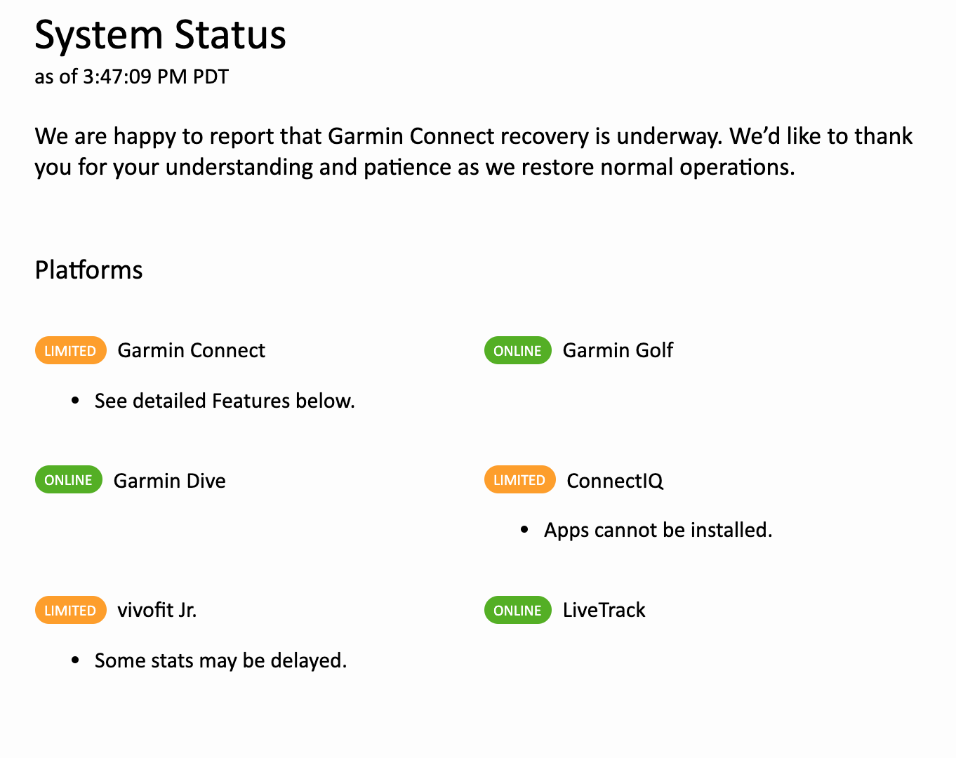
Following a ransomware attack last week that left Garmin Connect and other services offline, the company is gradually restoring its internet capabilities.
For those who make use of fitness tracking, however, Garmin Connect workouts are still not able to sync to devices and the app is under maintenance, reports CNN.
“We are happy to report that Garmin Connect recovery is underway,” the company announced on the Garmin Connect website. Some platforms have been given the green light, while others are offering limited services.
The company also said in a statement that there is “no indication” that customer data was accessed, stolen or lost.