The European GNSS Agency (GSA), with the European Commission, has published an information note on the Galileo High Accuracy Service (HAS). The 16-page document provides an overview of the main characteristics of the service, information on features such as service levels, target performance, an implementation roadmap, and an overview of the target markets for the service.
Target markets for Galileo HAS include geomatics, precision agriculture, consumer solutions and the space sector.
The market for high-accuracy positioning is dynamic, driven by various factors, including
emerging applications such as autonomous vehicles and drones;
technological advances such as dual-frequency chipsets for the mass-market; and
the market situation, with cheap or free-of-charge augmentation services available in some countries.
These factors are resulting in the democratization of high accuracy, which is becoming a more widespread commodity, rather than the exclusive domain of professional applications.
With the Galileo HAS, Galileo will pioneer a worldwide, free high-accuracy positioning service aimed at applications that require higher performance than that offered by the Galileo Open Service.
Benefitting several markets
Target markets for the HAS include geomatics, agriculture or consumer solutions. Transport is also a major potential target market, with possible applications in aviation, road, rail and maritime and inland waterways.
In these markets, the HAS will provide high-accuracy precise point positioning corrections for Galileo and GPS free of charge, in the Galileo E6-B data component and by terrestrial means, to achieve real-time improved user positioning performances, with a positioning error of less than two decimetres in nominal conditions.
“With its High Accuracy Service, Galileo will be the first satellite constellation able to provide a high-accuracy precise point positioning service globally, directly through the Signal in Space,” said GSA Executive Director Rodrigo da Costa. “This will be another key differentiator of the Galileo system, giving it a competitive advantage over other systems and allowing it to foster innovation in both consolidated and emerging markets.”
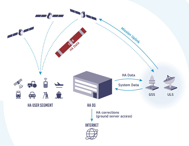
Galileo HAS high-level architecture. (Image: GSA)
HAS Initial Service
HAS Phase 1 will cover the provision of an initial Galileo HAS resulting from the implementation of a high-accuracy data-generation system that processes Galileo data only.
Phase 2 will see full provision of the Galileo HAS, meeting its target performance of 20-cm worldwide positioning accuracy after 2024.
Through the HAS, Galileo will offer a unique service with the transmission of corrections directly via Galileo satellites, allowing free high-accuracy positioning globally, for everyone.
Agreement focuses on increasing development and capacity for ultra-compact, low-power laser-beam scanners to expand the market
STMicroelectronics and OQmented, a startup focused on MEMS-mirror technology, have agreed to collaborate on the advancement of the technology for augmented reality and 3D-sensing markets. Micro-electro-mechanical systems (MEMS) combine tiny 3D mechanical structures and electrical circuits on a chip to sense and actuate activity.
The joint effort aims to build on the expertise of both companies to advance the technology and products behind the leading MEMS-mirror-based laser-beam scanning solutions in the market.
ST manufactures MEMS sensors, actuators and related components including drivers, controllers and laser-diode drivers. ST is contributing its MEMS design and manufacturing resources to the collaboration.
OQmented plans to further industrialize and mass produce its Bubble MEMS technology, a patented 3D glass-encapsulation method of hermetic vacuum sealing of MEMS micro-mirrors. The glass bubbles eliminate environmental contaminants and minimize light-refraction effects.
Automotive grade. Vacuum sealing is a key element for meeting automotive-grade requirements, while simultaneously reducing power consumption by an order of magnitude and enhancing performance for resonant, bi-axial scanners, where the MEMS mirrors move in both axes at their resonant frequency, creating an ultra-compact and power-efficient scanning solution. The resonant mirrors are suitable for display and 3D sensing applications in mobile devices.
“In teaming with ST, we’ve chosen a solid semiconductor partner that has demonstrated its leading position in design and manufacturing of MEMS products, particularly MEMS mirrors, over the past 20 years,” said Ulrich Hofmann, CEO/CTO and co-founder, OQmented. “Combining ST’s expertise in developing, marketing, and manufacturing key components for laser-beam scanning solutions with OQmented’s knowledge and intellectual property will contribute greatly to our product offering, manufacturing capacity, and marketing channels, while also expanding the market in numerous application areas.”
“Our goal in working with OQmented is to leverage our shared expertise and deep understanding of laser-beam scanning technologies with the mutual vision to continue the adoption and growth of laser-beam scanning in key applications, such as augmented reality and 3D sensing,” said Anton Hofmeister, vice president and general manager, MEMS Microactuator Division, STMicroelectronics.
From the joint effort, ST and OQmented plan to market a wide range of scanning solutions. These would include MEMS mirrors, MEMS drivers and controllers, and complete reference designs of laser-beam scanning engines for a range of applications. The companies also intend to collaborate on a laser-beam scanning roadmap and the development of future technologies and products.
Dual-frequency timing module provides anti-jamming and anti-spoofing capabilities
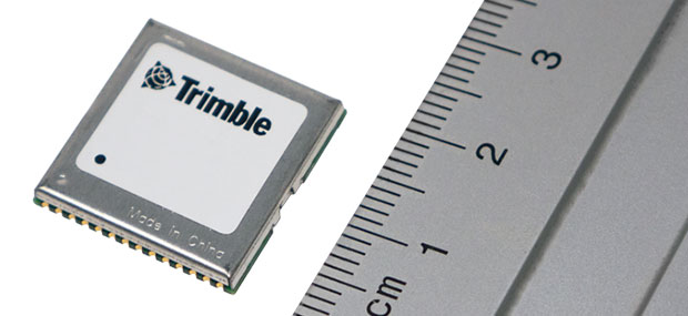
Photo: Trimble
Trimble has introduced its first dual-frequency embedded timing module that provides next-generation networks with 5-nanosecond accuracy.
Surface mountable, the Trimble RES 720 GNSS timing module can be integrated into network equipment. It uses L1 and L5 GNSS signals to provide superior protection to jamming and spoofing, mitigates multipath in harsh environments, and adds security features to make it suitable for resilient networks.
Precise timing and synchronization optimizes and improves wireless network performance. At 19 x 19 millimeters, the RES 720 module provides a low-cost, easy-to-use, highly accurate and reliable GPS timing source for critical infrastructure in a broad range of industries. The RES 720 is suitable for 5G Open RAN/XHaul, smart grids, data centers, industrial automation and satellite communication networks, as well as calibration services and perimeter monitoring applications.
The RES 720 meets the resilient timing requirement mandated by the U.S. 2020 Executive Order (EO13095) for timing services and critical infrastructure operators. Using dual-frequency (L1 and L5), RES 720 provides better multipath detection capabilities than single frequency, and provides protection against signal jamming and spoofing. Multi-band capability helps compensate for the ionospheric error from multi-GNSS satellite constellations, while reducing the timing error under clear skies to less than 5 nanoseconds. To further improve its accuracy locally, the RES 720 module features differential timing modes for highly accurate local timing.
Powered by Trimble’s Smart GNSS Assurance technology, the RES 720 offers protection against jamming and hacking of signals with automatic fallback to available GNSS signals. Infrastructure equipment suppliers, system integrators and network operators can benefit by integrating highly accurate synchronization capabilities into their network and synchro-phasor devices, while enabling resilient timing for critical infrastructure.
The RES 720 is expected to be available in the second quarter of 2021.
A new enterprise platform available this summer provides real-time location and asset tracking across a campus with Bluetooth technology.
Link Labs’ AirFinder OnSite is an internet of things (IoT) asset-tracking platform for campus-based environments. Using a Bluetooth Low Energy (Bluetooth LE) radio to support both Bluetooth LE and phase ranging brings location accuracy with Bluetooth LE tags to the sub-meter level.
According to Link Labs CEO Bob Proctor, AirFinder OnSite eliminates the need to choose between high-cost/high-accuracy ultra-wideband solutions or low-cost/low-accuracy traditional Bluetooth LE solutions.
Proctor sees it potentially used in distribution centers and warehouses, as well as IoT applications in manufacturing, healthcare and logistics management. With seven patented or patent-pending Link Labs technologies, AirFinder OnSite was developed on Nordic Semiconductor’s nRF52833, a general-purpose multiprotocol system-on-chip with a Bluetooth LE direction-finding-capable radio.
Innovations at the firmware level solve an array of technical challenges for an enterprise-grade solution: ranging methodology, interference avoidance, a location algorithm, power efficiency and scalability to high-tag densities.
These innovations allow asset location to be fine-tuned to the sub-meter level, making it a precise Bluetooth-based location technology.
AirFinder does not require an internal Wi-Fi system and is capable of operating on its own secure network layer via Link Labs’ Symphony Link or other third-party network layer technology, such as Bluetooth mesh technologies. The AirFinder platform provides remote monitoring and device management, allowing the system to be optimized for different use cases.
This spring, early adopters will support pilot deployments of AirFinder OnSite.
Critical infrastructure services such as telecommunications, utilities, transportation and defense are of national strategic importance. The U.S. Cybersecurity and Infrastructure Security Agency (CISA) lists 16 such sectors considered vital for security. Presidential Policy Directive 21 (PPD-21): Critical Infrastructure Security and Resilience advances a national policy to strengthen and maintain secure, functioning and resilient critical infrastructure.
Together, positioning, navigation and timing (PNT) are necessary for the functioning of a nation’s critical infrastructure. However, ubiquitous use of GPS as the primary source of PNT information introduces vulnerabilities. CISA, through the National Risk Management Center, works with government and industry partners alike to strengthen the security and resiliency of the national PNT ecosystem in the U.S. In early 2020, Executive Order (E.O.) 13905 on Strengthening National Resilience through Responsible Use of Positioning, Navigation, and Timing (PNT) Services was signed to strengthen, through policy promotion, the responsible use of PNT services by government and infrastructure operators.
The following is a review of cost considerations and exploration of the three key elements for critical infrastructure that help to strengthen PNT, focused on synchronization and precise timing: redundancy, resiliency and security.
Evaluating Cost and Location
It is often hard for operators to justify the resiliency, redundancy and security costs associated with deploying these capabilities at every layer of the architecture. New timing and synchronization solutions and design choices are leading to the right cost structures to deliver robust and reliable solutions.
The dilemma between cost and solution type is typically related to which deployment location is considered. With the evolution of technologies such as the migration from SDH/TDM to Ethernet and the development of LTE/4G and 5G in mobile, the number of aggregation offices and, above all, of network access sites at the edge has exploded. This inevitably leads to devices becoming much smaller, typically 1U-rack mountable devices, and with a cost in line with the much smaller size of edge base stations (small cells and gNodeBs).
Operators are left with the question: What is the best way to provide redundancy, resiliency and security in this environment? There are two core levels to consider — the architecture level and design level.
Exploring Redundancy
Redundancy at the architecture level can be engineered with core functions at both ends of a deployment (east/west) with dual paths for directional redundancy and high-performance capabilities for efficient high-accuracy time transfer over the long haul for cost-effective distribution. The virtual Primary Time Reference clock (vPRTC) architecture is such an architecture-level solution.
Redundancy can also be considered in the device itself, where the design choices are critical. Smaller devices cannot realistically be cost-effectively designed with modular hardware redundancy. The innovation here is to offer software redundancy, so a distributed, low cost, efficient and high-performance distributed solution can be deployed. A hardware module is typically expensive for two reasons: cost, and because the redundant module takes the space of another module, typically for input and output ports.
Hardware module redundancy often leads to a tradeoff between adding redundancy and losing capabilities, such as a choice between 10-gigabyte Ethernet (GE) support or multi-band GNSS or other compromises if redundancy is enabled. On the other hand, with software redundancy no tradeoff is necessary. Redundancy can be introduced while preserving all existing capabilities; no inputs or outputs are eliminated, no multi-band GNSS capability is eliminated. Redundancy is introduced via a software upgrade; therefore, it does not remove any hardware. Hardware redundancy, however, means duplicating an existing module with a similar module inside the device; this new module takes the slot of an existing module, and the function of that existing module is lost when it is removed from the unit.
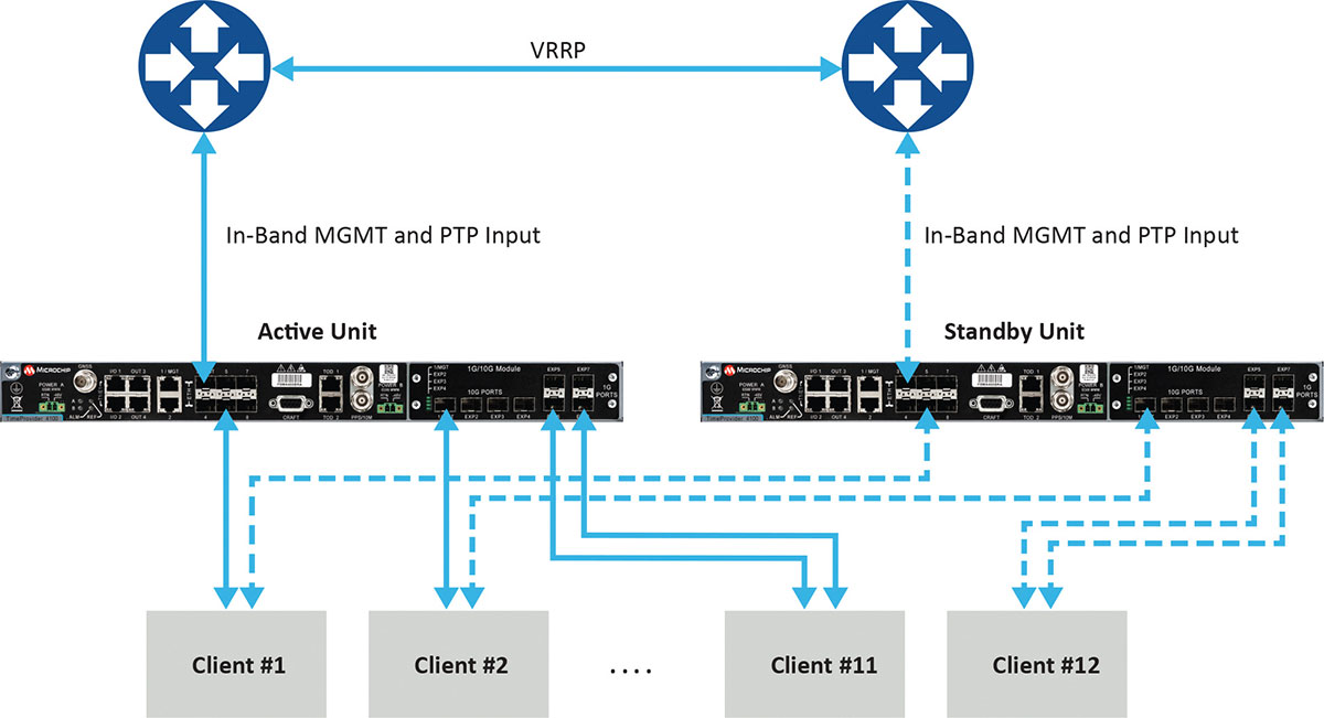
Figure 1 depicts a commonly deployed redundancy use case with two aggregation routers using virtual router redundancy protocol (VRRP).
Figure 1. Example of redundancy connectivity between the active and standby units. (Image: Microchip)
Software redundancy is a dual-unit scheme based on two reasonably priced devices, one active and the other on standby. It is more cost-effective for two reasons. First, it does not involve a costly device design with expensive hardware modules. Second, each unit (passive and active) keeps all of its capabilities compared to a hardware redundant design, which involves duplication of modules in the device, thus reducing the existing possible capabilities to host the redundant module.
Software redundancy provides total redundancy of the whole device because the active and standby units are the same. One hundred percent of the capabilities are redundant, including oscillator, GNSS receiver, ports and input/outputs. A hardware module is only redundant for its own features, not the rest of the unit.
Leveraging Resiliency
Resiliency at the architecture level is key to engineering the network so grandmasters in the deployment can be connected to each other. Some grandmasters are connected to GNSS as their source of time and frequency. It is key to connect these systems to other 1588 grandmasters to enable assisted partial time support (APTS) and to leverage key innovation such as automatic asymmetry correction (AAC).
AAC is a key (patented) differentiator in a resilient design that enables calibration of the different paths a PTP flow may use to/from upstream grandmasters, thus allowing for a backup in case GNSS fails at the location of a grandmaster. A backup path to an upstream grandmaster can guarantee uninterrupted and precise time and phase operation. This architecture makes sure that GNSS can be backed up by IEEE 1588 Precision Time Protocol (PTP) when GNSS is interrupted, with the best path being utilized.
The alternative architecture choice is virtual PRTC (vPRTC), which enables operators to leverage redundancy and resiliency via a chain of high-performance boundary clocks using PTP over long distances for high accuracy, typically over optical networks. This architecture reduces reliance on GNSS and uses PTP as its primary source of time and phase.
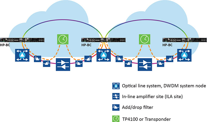
Figure 2 depicts an optical network deployment with a dedicated optical timing channel (OTC) for high-accuracy distribution of phase over long distances.
Figure 2. Optical network deployment with OTC. (Image: Microchip)
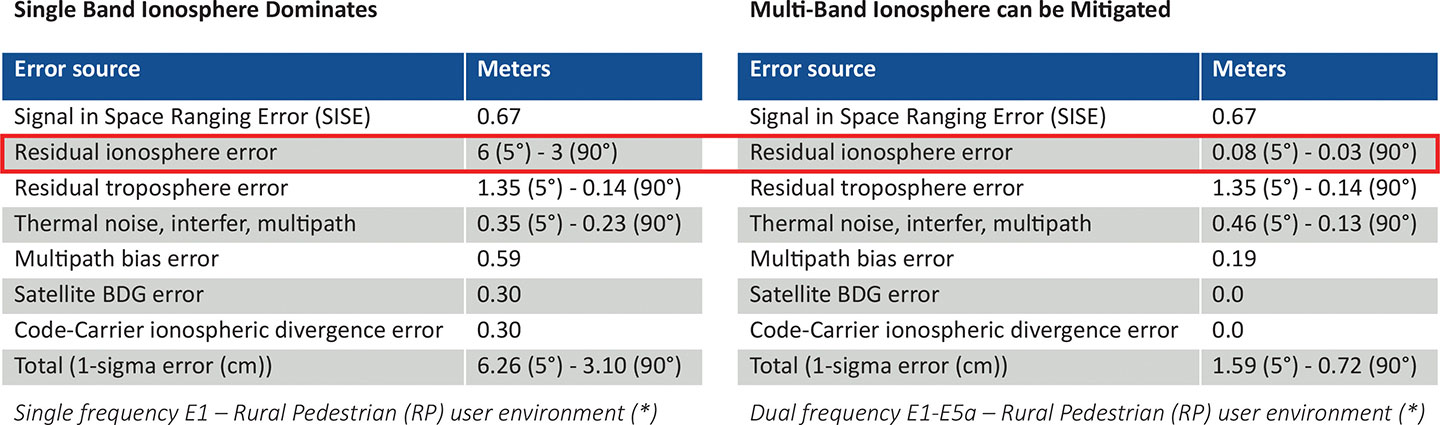
Resiliency at the device level starts with the right choice of an oscillator, from OCXO to atomic clock (Rubidium) — and is dependent on the location, use case and respective requirements for timekeeping holdover performance. Also, the choice of GNSS receiver is key. Some typically support a single frequency, yet ionospheric phenomenon can create significant time delays during cyclical events such as solar storms. To mitigate such delays, a multi-band GNSS receiver is required.
Figure 3 depicts a comparison between single-band and multi-band time delays due to ionospheric effects and shows how multiband clearly mitigates the time error as highlighted in red.
GNSS satellites transmit time information in several frequency bands. The delay difference between signals at different frequencies provides information about ionospheric impact on the absolute delay. This enables multi-band GNSS receivers to compensate for delay variations of radio signals transmitted from the satellite to the receiver. Embedding a multi-band receiver mitigates these time delays, which is critical for applications requiring Primary Reference Time Clock class B (PRTC-B),40 ns, as well as enhanced PRTC (ePRTC) 30 ns.
These device design choices are equally important. The GNSS receiver can be embedded inside the unit on the main board, or it can be offered as a hardware module, often at an additional cost, and may impact and replace an existing module that needs to be ripped and replaced. It may be preferable to have the unit enabled with a multi-band receiver and have the multi-band capability turned on via a license as opposed to offering a multiband option on a hardware module, as this becomes a tradeoff with other important capabilities.
Evaluating Security
Security is of utmost importance. Authentication and authorization via standard mechanisms such as Terminal Access Controller Access Control System + (TACACS+) and Remote Authentication Dial-In User Service (RADIUS) provide the benefit of a standard security framework. In addition, two-factor authentication (2FA) is an extra layer of protection used to ensure the security of accounts beyond just a username and password.
Also, it is key to provide Secure Shell (SSH) extensions with various levels of security profiles to offer more granularity for the types of users and related access rights and limitations. Offering high-security profiles provides for the definition and enforcement of the most stringent access rules to the system. Scripting vulnerabilities and relevant Common Vulnerabilities and Exposures (CVE) need to be addressed to make sure all potential security holes are being reviewed and addressed.
Plus, evolving jamming and spoofing threats need to be part of the precise time security strategy and implementation via monitoring of signals and consistency checks and remediation. Automatic gain control (AGC) and other metrics can be leveraged to provide thresholds with interpretation of results, as well as mitigation actions when encountered.
Final Decision Making
To ensure continued performance, it is critical to make the right architecture choices. A thorough network engineering study should include the locations where grandmaster units need to be deployed and their performance and accuracy requirements. These steps will guide which types of precise time and synchronization devices need to be selected
In addition, network planners and synchronization engineers should pay careful attention to design choices such as fanless devices versus devices that require a fan, modular hardware redundancy versus software redundancy, and the related advantages in terms of cost and tradeoffs — as well as similar choices regarding embedded or modular GNSS.
These choices can lead critical infrastructure operators to deploy redundancy, resiliency and security at all layers.
For architecture choices and solutions, visit vPRTC..White papers on this topic and others are also available. Additional information on devices and redundancy software schema is here.
Eric Colard is head of Emerging Products, Frequency & Time Systems at Microchip. He leads the product line management for Microchip’s TimeProvider 4100 and Integrated GNSS Master solutions for the telecom, utility and other industries.
IoTeX has selected Nordic Semiconductor’s nRF9160 low-power System-in-Package (SiP) with integrated LTE-M/NB-IoT modem and GPS receiver to provide the cellular internet of things (IoT) connectivity for its Pebble Tracker.
The Pebble Tracker provides trusted location, environment and motion-tracking data for global asset tracking and industrial supply chain applications.
Critical features strengthen security from hacking and data corruption, meeting the demand of applications that require strong data security and integrity protection throughout the supply chain, the company said.
There are two versions of Pebble Tracker. The first targets blockchain and IoT developers, while a second commercial version is designed for the asset tracking and industrial supply chain markets.
The product combines an environmental sensor, a motion sensor (gyroscope and accelerometer) and an ambient light sensor. It enables cellular network connectivity and integrated GPS support in a global version supporting precise, long-range tracking of asset data using established cellular infrastructure.
The nRF9160 syncs with the IoTeX blockchain, enabling large-scale, decentralized asset-tracking applications. It sends environmental and GPS data securely across global cellular networks to blockchain-based backend services and applications. There, the data is used to determine whether smart contracts have been satisfactorily fulfilled. For example, the trusted tracker data can reveal if, when, and where an asset has been mishandled.
The acquisition will expand Verizon’s robotic capabilities to power the future of robotic automation for enterprise customers
Verizon has entered into a definitive agreement to acquire incubed IT, the creator of a software platform providing autonomous navigation tools to administer, manage and optimize mixed fleets of robots in industrial settings.
“This acquisition further demonstrates Verizon’s commitment to developing new and innovative businesses and use cases leveraging the power of 5G,” said Rima Qureshi, chief strategy officer at Verizon. “Mobile robot orchestration is a real and emerging challenge faced by enterprises today. By integrating incubed IT’s autonomous software with Verizon’s 5G platform, we will have the ability to power robotic automation at scale. This will create new opportunities for enterprise customers to better and more effectively monitor and optimize their business processes.”
Upon closing and as Verizon continues to expand its 5G coverage, capacity and mobile-edge compute capabilities, incubed IT’s autonomous software will enable enterprise customers to gain new efficiencies as they scale their autonomous mobile robot fleets.
Incubed IT’s award-winning software enables robots to localize and navigate autonomously and can be easily integrated into nearly any mobile robot. Their products include:
Smart Shuttle Navigation Toolkit: Transmits near real-time data to navigate autonomous mobile robots (AMRs)
Fleet Management Server: Manages AMR Fleet & Routing Operations
Data Monitoring and Analytics: Near real-time monitoring and advanced
reporting
“Incubed IT’s next-generation software and autonomous fleet management server are foundational components for the future of terrestrial robotics,” said Elise Neel, vice president of Verizon New Business Incubation. “When we combine incubed IT’s capabilities with the reliability, responsiveness and vast capabilities of Verizon’s 5G platform, we will enable faster, less expensive and more effective adoption of robotic automation for enterprises everywhere.”
Incubed IT’s autonomous navigation software features include:
No need to specify transport paths up front
No predefined paths
Instant rerouting
Obstacle avoidance
Safe operation in areas with other vehicles and humans
Incubed IT’s employees will join the Verizon New Business Incubation team, whose mission is to scale new automation businesses, fueled by the inherent orchestration power of 5G. The incubed IT team will continue to drive development, sales and support for its customers and suite of products across a fleet of diversified robotic partners.
“We are proud of all the incubed IT team has accomplished to get us to this point, and we look forward to expanding on our successes and capabilities,” said Stephan Gspandl, incubed IT CEO. “By joining the Verizon team, we have the opportunity to bring our software to broader audiences and to help create the future of robotic automation.”
The transaction is subject to customary closing conditions and is expected to close in the first half of 2021.
A new paper by two Qualcomm engineers imagines restructuring Loran technology to more easily incorporate timing signals into telecommunication systems.
The paper, titled simply “LORAN-5G,” was authored by Guttorm Opshaug and Dave Tuck. It envisions moving away from legacy pulsed signals to a more continuous wave form which would allow significantly lower power transmissions.
According to Opshaug, “Another big advantage that may not be as apparent, is the built-in orthogonality in the signal structure of OFDM. This means that a receiver would be able to detect very weak signals from distant towers at the same time as receiving signals from a very strong close tower. Such robustness towards near-far effects is critical for terrestrial navigation use.”
Another change would be a marked increase in the capacity of the Loran data channel to more than 2.6kbps. “This could open opportunities for additional service options and/or reduce latency of existing ones,” according to Tuck.
UrsaNav CEO, Charles Schue, expressed great interest in Qualcomm’s paper. UrsaNav is a long-time provider of Loran equipment and consulting. “The intersection of PNT and communications discussed in the Qualcomm paper is exactly what is needed to ensure that PNT systems evolve and stay relevant,” he said. “In fact, we build our software defined transmitter and receiver solutions to specifically include the ability to produce and use these types of signals.” A Cooperative Research and Development Agreement between UrsaNav and the Department of Homeland Security demonstrated these type of potential upgrades in 2012.
This paper is the first publicly released effort examining the use of Loran technology to support 5G telecommunications. The general concept was discussed in a 2016 paper by the Alliance for Telecommunications Industry Solutions’ (ATIS) Synchronization Committee. Based on the paper, ATIS in 2017 encouraged members of Congress to pass legislation that would become the National Timing Resilience and Security Act of 2018 (NTRSA).
There are tradeoffs. Opshaug and Tuck’s proposal would replace the legacy Loran standard signal with a new one.
“I was in the midst of developing proposals for the 3GPP standards organization when I first heard about the NTRSA,” said Opshaug. “5G seemed like exactly the kind of critical infrastructure that could benefit from a backup timing solution.”
“We wanted to bring some of the ideas used to develop 5G position and timing to Loran,” said Tuck. “Using Loran as the timing synch could enable 5G to improve overall infrastructure resilience.”
Yet, as with most things, there are tradeoffs. Opshaug and Tuck’s proposal would replace the legacy Loran standard signal with a new one. This would require redesign of receivers and some transmitters. The proposal could support denser deployments to further improve resiliency.
“The new signals seem incompatible with existing receivers and Loran networks,” according to Professor Jiwon Seo of South Korea’s Yonsei University. South Korea is upgrading its Loran-C network to the eLoran standard. The new South Korean system will be compatible with neighboring Russian and Chinese Loran systems, so users will be able to benefit from signals anywhere in East Asia. Until 2010 signals from the U.S. Loran system cooperated with these networks as part of the Far East Radionavigation Service (FERNS).
Navigation expert Logan Scott is intrigued by the proposal but observes that more work needs to be done. “This is an interesting waveform,” he said, though he had questions about the propagation channel, antennas, and possible distortion.
The authors acknowledge that much more needs to be done, including better determining timing and positioning accuracy.
Yet they and others see potential in combining the very different phenomenologies of low frequency, 100KHz Loran and 5G telecommunications which typically operate in the gigahertz range.
Opshaug and Tuck’s paper LORAN-5G can be accessed here.
New tech can track vehicles, drones and cargo remotely within centimeters — key to safe adoption of autonomous vehicles, flying objects and machinery
Vodafone has successfully used new precision positioning technology to remotely track a vehicle to within 10 centimeters of its location, an improvement of more than three meters compared to its current system.
Vodafone is working in partnership with Sapcorda, using Vodafone’s global internet of things (IoT) platform, which has 118 million connections worldwide.
Vodafone expects the technology to enable applications that warn autonomous trucks of obstacles, tell first responders the position of critical medical drones, and give operators the precisely location of important cargo.
Pinpoint accuracy is critical to the acceptance and mass adoption of autonomous vehicles on the road and in factories, airports, dockyards and any site where machines are in motion. A matter of centimeters can be crucial to ensuring the safety of passengers on a driverless bus, or knowing the precise location of a medical drone. a
The tracking technology will also allow an autonomous truck to mind other road users, including cyclists, whose e-bikes can automatically transmit their position and intended direction of travel.
“We might not be able to locate a needle in a haystack yet, but we are getting close,” said Vodafone Business Platforms and Solutions Director Justin Shields. “What we can do now is take new digital services like this one, integrate it with our global IoT platform and fast networks, and offer it securely at scale to many millions of customers.
“Our in-building 5G and IoT services already allow manufacturing plants, research laboratories and factories to carry out critical, and often hazardous, precision work with robots. Now we are applying the same levels of accuracy to the outdoor world.”
Vodafone is redefining its network and technology on a Telco as a Service (TaaS) model. It makes key network capabilities available through common APIs in a cloud platform to deliver new software, video and data applications at scale, in addition to gigabit-capable connectivity.
Vodafone said the TaaS model will benefit large enterprises, improving their ability to locate critical assets, precisely align machines such as driverless trains at platforms, and let farmers, airports, and fleet operators know the exact whereabouts of their autonomous vehicles.
Vodafone IoT-enabled vehicles, machinery and devices — when linked with Sapcorda’s comprehensive network of GNSS receivers and augmentation technology — improves location accuracy by correcting for things like the curvature of the earth, atmospheric delays and clock differences of global positioning satellites. This offers corporations hyper-precise positioning that they can use to ensure a safe environment for their employees, their customers, the public and their machines.
Combined with video and onboard diagnostics, the technology will also allow vehicle operators to carry out accurate location-sensitive remote inspections and even pause machines such as grass cutters on public footpaths when they encounter people.
PPP-RTK method. Vodafone is adopting the precise point positioning – real-time kinematics (PPP-RTK) method with ground-level GNSS stations to achieve the best error correction. GNSS signals are processed and GNSS corrections are sent out to enhance the position accuracy of the vehicles receiving them.
Vodafone is able to equip any number of vehicles with an in-built IoT SIM, and deliver the positioning data at speed using its gigabit-capable networks.
Vodafone recently put this to the test by tracking in real-time the exact lane that vehicles were traveling in during a combined journey of more than 100 kilometers in varying weather conditions.
Sapcorda provided the data feed, which enabled the GNSS signal to be corrected, to deliver the critical-level of positional accuracy. A precise positioning service complements the existing asset tracking and fleet telematics solutions already provided by Vodafone Business for enterprise customers across 54 countries.
MediaTek’s Dimensity 700 5G smartphone chipset is a system on chip (SoC) designed to bring advanced 5G capabilities and experiences to the mass market.
The Dimensity 700 joins MediaTek’s Dimensity family of 5G chips, which is designed to give device makers a suite of options for 5G smartphone models. The chips range from flagship and premium to mid-range and mass market devices to make 5G more accessible for consumers everywhere.
GNSS signals received include GPS L1CA and L5, BeiDou B1I and B2, GLONASS L1OF, Galileo E1 and E5, QZSS L1C and L5, and NavIC.
“With our expanded Dimensity portfolio, we’re bringing the latest 5G capabilities to every smartphone tier so more people can enjoy 5G experiences,” said JC Hsu, corporate vice president and general manager of MediaTek’s Wireless Communications business unit. “The Dimensity 700 has an impressive mix of 5G connectivity features, advanced camera capabilities like night-shot enhancements, and multiple voice assistant support, all in a super power-efficient design.”
Advanced connectivity features include 5G carrier aggregation (2CC 5G-CA) and 5G dual-SIM dual-standby (DSDS), giving users access to the fastest speeds and 5G-exclusive Voice over New Radio (VoNR) services from either connection, the company said.
On the processing power side, the chip integrates two Arm Cortex-A76 big cores in its octa-core CPU and operates at up to 2.2GHz.
MediaTek’s Dimensity 5G family of chips are designed for 5G devices across all tiers, and with the Dimensity 700 5G devices will now be accessible to even more consumers.
For full specifications and further details on MediaTek’s Dimensity 700 series and 5G portfolio are on the MediaTek website.
ADVA has launched a set of edge and access network synchronization devices with enhanced capabilities for next-generation applications such as 5G. These latest Oscilloquartz solutions address key challenges for a wide range of industries by bringing new levels of timing accuracy and resilience to edge networks.
The OSA 5412 and 5422 offer precise phase, frequency and time-of-day synchronization and can be used for time-as-a-service applications. Communication service providers, enterprises, broadcast networks and power utilities can deploy synchronization technology at the edge that features multi-band for nanosecond accuracy.
The OSA 5412 and 5422 utilize in-service sync probing and assurance as well as innovative GNSS assurance capabilities. The products also provide support for eight field-upgradeable 10Gbit/s ports, ensuring the scale and efficiency needed for next-generation smart grids, industrial IoT applications and 5G connectivity.
The OSA 5412 is a highly flexible access network synchronization solution that offers compact and cost-effective timing distribution and assurance. The OSA 5422 is engineered for the most extreme conditions. It meets stringent frequency and phase synchronization requirements, delivers the best holdover performance of any edge device on the market, and supports multiple legacy interfaces such BITS and IRIG.
Both solutions address new ITU-T specifications, including for class A and B PRTCs, ePRTCs with strict holdover requirements, and the newly improved class C and D boundary clocks. They also feature onboard multi-band, multi-constellation GNSS receivers that overcome ionospheric delay variation far more cost-efficiently than rival solutions using high-end rubidium oscillators.
The OSA 5412 and 5422 support multiple PTP profiles, NTP and SyncE with a high number of 1/10GbE ports. Both devices are engineered with optional OLED display and with hot-swappable modules and power supplies to be easily upgraded in the field.
“Our latest solutions build on the great success we’ve had with our access synchronization product line. Now operators can harness the power of multi-band GNSS receivers to deliver highly accurate, UTC-traceable timing at the network edge. That enables the availability and precision that will be essential for tomorrow’s services,” said Nir Laufer, senior director, product line management, Oscilloquartz, ADVA.
“By extending the feature set of our edge technology, we’re empowering CSPs to smoothly transition to the reliability and accuracy required for 5G and, at the same time, enabling our unique innovation to be used across a wide range of verticals,” Laufer said. “With support for 10Gbit/s and 1Gbit/s interfaces as well as hardware timestamping, our access timing products are the ultimate in future-proof, space-efficient synchronization.”
“Access grandmaster clocks need to meet stricter demands for accuracy and reliability than ever before, and many industries have their own specific set of stringent timing requirements. That’s why we’ve evolved our portfolio of edge and access network synchronization solutions for the specific challenges of the 5G era,” said Gil Biran, general manager, Oscilloquartz, ADVA.
“Our OSA 5412 and 5422 answer the most urgent timing needs of mission-critical infrastructure in multiple verticals,” Biran said. “They provide nanosecond precision, an abundance of fan-out interface options and operational simplicity thanks to the management and monitoring capabilities of our Ensemble Controller with Sync Director. Operators of broadcast, healthcare, financial networks and more now have a straightforward and affordable path from legacy to next-generation timing.”
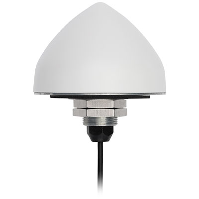
The new TW5382 smart GNSS antenna by Tallymatics Inc. is designed for high-accuracy 5G timing. Tallymatics focuses on GNSS timing antennas; it is a division of the Calian Group of Companies, along with Tallysman Inc.
The TW5382 is a multi-band, multi-constellation 5G smart GNSS antenna/receiver that provides 5 ns (1-sigma, clear sky view) timing accuracy. It consists of two components: a Tallysman GNSS Accutenna technology antenna and a professional-grade GNSS timing receiver module.
Accutenna supports the full bandwidth of the TW5382 receiver, strong multipath mitigation and deep filtering, in a compact IP69K enclosure. These features enable the antenna to provide a strong, pure, in- band, right-hand circular polarized signal to the receiver.
Photo: Tallysman
The TW5382’s professional-grade multi-constellation and multi-signal timing receiver tracks GPS/QZSS (L1/L2), GLONASS (G1/G2), Galileo (E1/E5b), and BeiDou (B1/B2) signals. Dual-frequency GNSS enables the receiver to minimize ionospheric delay and enhances multipath mitigation.
Other key features of the GNSS receiver include support for anti-jamming and anti-spoofing, Timing-Receiver Autonomous Integrity Monitoring (T-RAIM), and GNSS augmentation systems: WAAS (USA), EGNOS (Europe), MSAS (Japan), and GAGAN (India), all of which provide orbit and clock corrections, a well as health and integrity information.
Multi-constellation tracking enables the GNSS receiver to report the Coordinated Universal Time (UTC) estimated by each constellation. The receiver can be configured to output either the GPS, GLONASS, Galileo, or BeiDou realization of UTC. The timing pulse can also be configured to suit the user’s requirements.
The TW5382 supports an RS-485 communication interface, which enables the receiver to be configured and monitored.
Lastly, combining the GNSS antenna and receiver in a single package ensures that each smart antenna will produce precisely the same timing signal, as each smart antenna cable delay will be virtually identical. Only the user’s time pulse cable length (smart antenna to user equipment) will have to be considered, which simplifies the operator’s installation.
Contact Tallymatics for more information concerning the ultra-precise TW5382 High Accuracy 5G Timing Smart GNSS antenna.