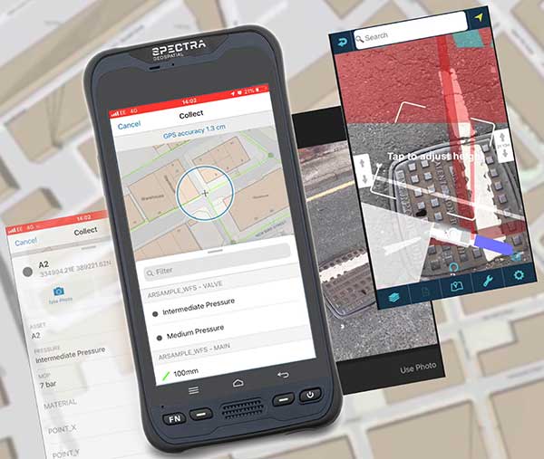
MGISS, a U.K. geospatial specialist, has released a new version of its web app TopoGrafi that allows for the display of 3D data in real-world models. With enhanced 3D data processing capabilities, TopoGrafi is an end-to-end platform for capturing buried asset data and processing it for augmented reality visualizations.
Aimed at the utility and infrastructure sectors, TopoGrafi is helping organizations in water and highway sectors enhance asset location data, improve on-site safety and reduce construction and maintenance costs.
Designed to be used alongside apps such as Esri Collector for ArcGIS, the TopoGrafi platform uses GNSS data.
It applies near-real-time conversions, transforming the recorded positions to local reference systems and aligning it with high-accuracy mapping including Ordnance Survey MasterMap.
The TopoGrafi toolkit also includes functionality to “snap” 3D features to each other and to other spatially referenced data, in order to create a true 3D model that can then be used to create Augmented Reality visualizations accessible from the desktop or in the field.
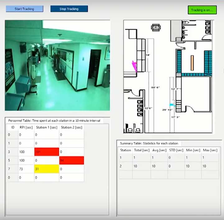
The dashboard shows how Ubihere tracks with both camera and tag technology. (Screenshot: Ohio Development Services Agency)
Ubihere has introduced a new 2D and 3D tracking technology for indoor and outdoor positioning.
Ubihere’s patented technology provides real-time asset location and information without GPS, making it an alternative for GPS-denied environments.
From Space Walks to Retail Stores
The inventor of the technology is geoinformatics professor Alper Yilmaz of The Ohio State University (OSU), who researched how to geolocate undercover officers based on motion video information, as well as astronauts on space walks.
OSU urged Yilmaz to commercialize his technology, and Rev1 Ventures served as the incubator. Ubihere launched under Rev1’s portfolio in 2016 in Columbus, Ohio.
Ubihere’s system is based on anonymous video analysis positioning technology, which is patented from OSU, coupled with tag technology and advanced machine learning analytics. The system’s tags, cameras, and software track assets to the centimeter. The assets are monitored through an anonymous video feed or the tags themselves, which are about the size of a credit card, and non-RFID.
The map for indoor environments can be generated from a building information model (BIM). Based on the building’s architecture, movement is tracked. In milliseconds it can hone in on an exact location within a centimeter, explained Alice Hilliard, Ubihere’s vice president of business development.
The location data is transmitted to a server or the cloud, depending on the customer’s preference. It is then loaded into dashboards that can be accessed from any device the client requests.
If a tagged object leaves a building, it will continue to be tracked with or without GPS. If the object stays within the building, it will never use GPS. Using GPS shortens the battery life, which ranges from 18 to 24 months. Battery life is also affected by the number of floors, temperature and usage.
Launching in Hospitals and Retail Stores
The tag offers a way to calibrate location in places such as hospitals, where tracking food carts or devices through lead-lined walls enables hospitals to maximize their efficiency.
“Imagine how many times a nurse or other caregivers go back and forth,” Hilliard said. “By tracking how people and objects move around, we can help departments figure out opportunities to lay out the floor better to allow the staff to save time and steps.
“With a blueprint loaded into the software,” Hilliard said, “the system knows whether a (tagged) IV pump went down the hall, turned left or right, entered an elevator, or was left in a patient’s room.”
The cameras can be installed in locations such as retail stores, enabling Ubihere to anonymously track a customer’s journey. Used together, the tag and camera can help stores determine whether a display is working, showing how many customers came in to shop, or how many looked at or touched items in a particular display.
For ecommerce, customer behavior can be tracked automatically in real time with Google Analytics and other SEO tools.
Other possible uses include factories and emergency-response teams. “If you were in a factory or even a nuclear power plant, OSHA guidelines establish that you have to have two people in the control room at all times,” explained Hilliard.
“Periodically, OSHA is required to monitor if the power plant is following that protocol. Instead of having someone sit there and oversee the situation, we can use our camera technology to anonymously collect workers’ whereabouts, which can then be easily pulled from the cloud. For response teams, an equipment failure that makes it difficult to locate a team member could be overcome with the tag technology. “
Ubihere’s machine-based algorithms can learn locations based on various types of sensors, Yilmaz said, adding that detecting odors isn’t out of the question.
The startup is now exploring potential applications of its GPS-free tracking technology. While initially focusing on beta tests in hospital and retail environments, Ubihere also has three projects with the U.S. Department of Defense.
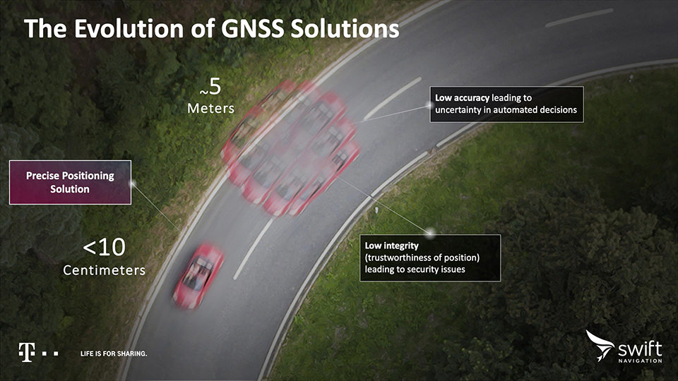
California-based Swift Navigation is partnering with Deutsche Telekom, an integrated telecommunications company based in Bonn, Germany. The partnership brings the precise positioning of Swift’s Skylark Cloud Corrections Services to Telekom’s comprehensive communications infrastructure via its new Precise Positioning product offering.
The Precise Positioning service is available across the United States and Germany, with expansion across Europe underway.
Autonomous applications. Autonomous applications, which rely on positioning accuracy, include self-driving cars, rail, autonomous robotic machine navigation, autonomous flight for unmanned aerial vehicles, last-mile delivery logistics, construction safety, and shared mobile positioning.
Swift and Telekom’s lane-level accurate Precise Positioning is specifically designed for level 2 and 3 automotive applications including advanced driver-assistance systems (ADAS), such as lane assist, highway autopilot, cellular vehicle-to-everything (CV2X) communications and lane level directions.
Standard GNSS positioning is accurate to three to five meters — unsuitable for autonomous systems. For higher levels of autonomous capability, high-precision localization is required to deliver accuracy down to the centimeter. This partnership brings the <10-centimeter accuracy of Swift’s precise positioning solution to Telekom customers.
Precise Positioning is a wide area, cloud-based GNSS corrections service that delivers real-time high-precision positioning to autonomous vehicles. Built from the ground up for autonomy at scale, the Precise Positioning service enables lane-level positioning, fast convergence times and high integrity and availability required by mass market automotive and autonomous applications.
Image: Swift
Hardware-Independent. The service is hardware-independent, allowing customers to choose their GNSS sensor ecosystem. It delivers a continuous stream of multi-constellation, multi-frequency GNSS corrections for a high-availability service that combines lane-level accuracy and world-class integrity at a continental scale.
“Swift Navigation is excited to continue our work with Telekom to bring Swift’s precise positioning GNSS expertise to Telekom’s broad customer base,” said Timothy Harris, co-founder and CEO at Swift Navigation. “This partnership is just the beginning of our joint service offering for autonomous vehicles across the EU.”
“Precise Positioning opens the doors to true autonomous mobility. Precise, safe and in the future also cross-national,” said Hagen Rickmann, responsible for business customers at Deutsche Telekom. “We are thus offering our customers an easy entry into the autonomous future. And we’re not just thinking of self-driving vehicles: The flexible offer is also suitable for use with drones and is even of interest to crane operators on construction sites.”
For ease in testing and integration, Swift and Telekom have created a Precise Positioning Evaluation Kit. The kit includes two workshops (onboarding and result review), testing hardware and software to connect to the Precise Positioning network for a three-month evaluation period and is available to purchase.
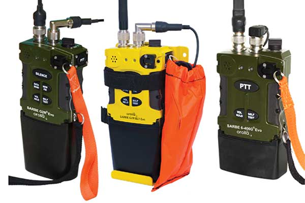
The new line of Sarbe search and rescue beacons. (Photo: Orolia)
Orolia is introducing the Sarbe Evo line at the Singapore Air Show, taking place Feb. 11-16 at the Changi Exhibition Centre. The line is being exhibited at Orolia’s Booth G10.
The search-and-rescue (SAR) beacon range has been improved to deliver upgraded operational capabilities, to meet the latest Cospas-Sarsat testability and maintenance requirements.
Part of Orolia since 2011, the Sarbe brand is a worldwide market leader for military (tri-forces) Personal Locator Beacons and Emergency Locator Transmitters. Sarbe beacons have been at the forefront of innovation in life saving Locator Beacons and critical communications for over fifty years.
Sarbe equipment is often integrated into air crew clothing such as Air Crew Life Preservers, ejection seats and survival packs, and can be optionally equipped with remote antennas and automatic activation.
The Sarbe Evo line offers new operational improvements in order to meet revised Cospas-Sarsat requirements in operating lifetime, location accuracy, voice signals management, integrated protocols, testability and maintenance.
Orolia’s development of the Sarbe Evo line has focused on the following key elements to improve customer safety:
Upgraded battery management with use-monitoring
Exceeds Cospas-Sarsat endurance requirements
Built-in-test further enhanced
More robust and frequent GPS/GNSS position acquisition with GPS, Galileo and GLONASS satellite constellations
Audio system improvement for greater clarity under all operating conditions
Introduction of the National Location Protocol
Rugged and reliability improvement (qualified to MIL-STD-810G standards) to support complex rescue missions in harsh environments
For both commercial and military needs in SAR operations, Orolia’s main goal remains the provision of highly accurate location data, and real-time voice and data communication to SAR operators through robust line of sight transmission.
Qorvo, a provider of RF solutions, is acquiring Decawave, as well as Custom MMIC. Financial details have not been disclosed.
“This acquisition is by far the biggest in the indoor location industry,” according to Bruce Krulwich, founder of Grizzly Analytics. “While the price is not disclosed, I and others have estimated it at $400-500 million.”
“Apple is using their own UWB chips in upcoming iPhones, but their own chips are too big and use too much power to be used in smartwatches or other small devices,” Krulwich said. “Decawave’s chips will enable Qurvo to sell compatible UWB chips to a much wider range of markets.Apple’s use of UWB in iPhones is the tipping point for UWB. With Apple’s stamp of approval, UWB will be incorporated into a wide range of location-aware electronics, including robots, drones, wearables, smartwatches and more.”
“The biggest implications for this acquisition are not only in the RTLS market, but also in the areas of internet of things, wearables and location-aware electronics,” Krulwich said. “UWB is being used in next-generation products like drones by Intel, robots by iRobot, and autonomous vehicle movement by Segway.”
Bob Bruggeworth, president and chief executive officer of Qorvo, said in a third-quarter financial release that the company was “looking forward to welcoming two industry-leading teams, Decawave and Custom MMIC, to the Qorvo family, expanding our technology portfolio and product offerings.”
Decawave is an Irish fabless semiconductor company specializing in precise location and connectivity applications. The acquisition will advance market penetration of IR-UWB and enable broad global adoption of the technology.
Decawave was founded in Dublin in 2007 by current CEO Ciaran Connell and CTO Michael McLaughlin. The co-founders had a vision that the new IR-UWB technology, based on a nascent IEEE standard, could deliver ultra-accurate location in a way that would revolutionize people’s lives like GPS did in the 1990s.
Twelve years later, IR-UWB is on the verge of becoming the next essential component technology, like GPS, Wi-Fi and Bluetooth before it. Already shipping in millions of smartphones and cars, and across more than 40 other verticals, IR-UWB is enabling accurate indoor location services, secure communications, context aware user interfaces and advanced analytics.
“We are thrilled to announce the acquisition of Decawave by Qorvo,” said co-founder and CEO Ciaran Connell. “We have created an incredibly unique technology, but we understand that to embrace the opportunity in front of us, we will need greater resources to execute at scale, accelerate our innovation and product launches and to continue to support our growing customer base with the same level of service.
“Joining forces with Qorvo’s leading expertise in RF technology, their experience in serving very high-volume markets like Mobile but also the thousands of customers in Industrial and Enterprise, is, for Decawave, a perfect combination to scale and further accelerate the adoption of IR-UWB.”
Eric Creviston, President of Qorvo Mobile Products, said, “We’re very pleased to welcome the Decawave team, which we believe will enhance Qorvo’s product and technology leadership while expanding new opportunities in mobile, automotive and IoT. We look forward to building on the groundbreaking work that Decawave has done and helping to drive new applications and businesses using their unique UWB capability.”
Decawave co-founder Michael McLaughlin added, “From proving a new technology, to building new markets and to today joining a Tier 1 semiconductor company, the past 12 years have been a challenging and fantastic journey.
“None of this would have been possible without the dedication and passion of Decawave employees as well as the constant support from our lead investor Atlantic Bridge, Act Venture Capital, Summit Bridge, Enterprise Ireland and our business angels. To all others who accompanied us on this journey we also say a sincere and profound thank you and we look forward to the next chapter for IR-UWB.”
In the coming months and years Decawave and Qorvo will:
Continue to contribute to the IEEE, Car Connectivity Consortium, FiRa and UWB alliance to define next-generation PHYs and protocols, ensuring interoperability across applications and fueling IR-UWB adoption,
Accelerate the roadmap of ICs and modules, leveraging their respective R&D strengths and product portfolio to bring even more IR-UWB solutions to the market,
Pursue existing partnerships and investments in enablement to offer flexible and easy to integrate IR-UWB solutions to our customers.
Sapcorda Services GmbH has released its SAPA (Safe And Precise Augmentation) Premium GNSS positioning service.
The SAPA service enables mass-market GNSS devices to operate with increased accuracy and reliability across Europe and the continental United States. The service’s technology unlocks advanced performance with instantaneous sub-decimeter position accuracy for devices used in all market applications.
SAPA is delivered using the open industry-recognized SPARTN format, which allows efficiently delivery of the correction data via internet and satellite broadcast. “When using our service, users across Europe and the United States can experience homogeneous, gap-free, advanced positioning performance with any GNSS hardware designed for high precision positioning,” CTO Rodrigo Leandro said.
The SAPA service is tailored for mass-market applications including innovative mobility solutions, IoT applications, and traditional markets such as maritime.
SAPA was designed from ground up to support safety-critical applications such as autonomous driving.
SPARTN (Safe Position Augmentation for Real-Time Navigation) is a high-accuracy, open- and free-to-use GNSS format tailored for broadcast distribution in mass-market applications.
Sapcorda Services GmbH is a GNSS service provider focusing on the emerging high-precision GNSS mass markets. The company has designed its technology and service offering to serve high volume automotive, industrial and consumer markets.
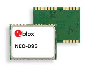
U-blox said its new NEO-D9S GNSS correction data receiver module provides an affordable approach to bringing centimeter-level accuracy to GNSS receivers.
The NEO-D9S receives from correction service providers broadcast on the L-band (1525-1559 MHz). A host processor can then decrypt this correction data and provide it to a high-precision GNSS receiver, combining corrections directly with readings from the satellite constellations to enable much more accurate position readings than those offered by GNSS signals alone.
Use of the NEO-D9S will also increase the availability of high-precision GNSS positioning data in areas with limited connectivity and reduce the amount of cellular data consumed by positioning receivers.
Customers are expected to include carmakers, both Tier 1 and OEMs, industrial system integrators that offer position-correction services, and any other applications that rely on very accurate positioning at low cost.
The NEO-D9S module is a correction-only receiver, based on the latest u-blox ninth-generation (D9) platform. This means that it will integrate easily with the u-blox F9 RTK GNSS receivers from u-blox, or can be used as part of a modular product roadmap. The module also integrates a TCXO and SAW filter to ensure good RF sensitivity and resilience to interference from adjacent channels.
The module includes the algorithms necessary to decode satellite data broadcasts. It is configured to work initially with whichever correction service has been set as default, but can be configured for any L-band data broadcast. It stores its configuration settings in non-volatile memory.
New modules enable entertainment, advanced connectivity features and next-generation artificial intelligence
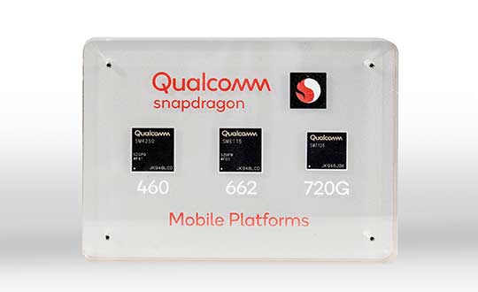
Qualcomm Technologies has launched three new mobile platforms — the Qualcomm Snapdragon 720G, 662 and 460 — to enable enhanced user experiences across connectivity, gaming and entertainment.
The new mobile platforms support dual-frequency (L1 and L5) GNSS to improve location positioning accuracy and robustness. The system-on-chip solutions also support the Indian NavIC (Navigation with Indian Constellation).
Seven constellations. For the first time supported on mobile, the Qualcomm Location Suite now supports up to seven satellite constellations concurrently, including the use of all of NavIC’s operating satellites for more accurate location performance, faster time-to-first-fix (TTFF) position acquisition, and improved robustness of location-based services.
“ISRO is satisfied with the efforts of Qualcomm Technologies Inc. towards incorporating NavIC and we urge OEMs to leverage it for future handset launches in India,” said K. Sivan, chairman, ISRO. “The availability of NavIC across multiple mobile platforms will help enhance the geolocation capabilities of smartphones in the region and bring the benefits of this indigenous solution to Indian consumers for their day-to-day use.”
The new modules also enable fast 4G connectivity speeds, deliver key Wi-Fi 6 features and integrated Bluetooth 5.1 with advanced audio via the Qualcomm FastConnect 6-series subsystems.
Artificial Intelligence. Designed to deliver new and improved AI user experiences across photography, voice assistants and virtually always-on scenarios for increased contextual awareness, the new platforms also feature the Qualcomm AI Engine and Qualcomm Sensing Hub.
“While we see a fast adoption of 5G across geographies globally, we do recognize the phenomenal boost that 4G has given towards enabling broadband connectivity for Indian consumers. 4G will continue to remain a focus area for Qualcomm Technologies for regions like India, where it will stay a key technology for connectivity,” said Rajen Vagadia, vice president and president, Qualcomm India Pvt. Ltd. “Our goal is to enable our partners to continue creating solutions that offer seamless connectivity access and exceptional mobile experiences, that consumers can count on.”
“Today’s smartphone users want fast, seamless connectivity, advanced features and long-lasting battery life,” said Kedar Kondap, vice president, product management, Qualcomm Technologies, Inc. “This expansion of our 4G lineup enables our partners to offer sophisticated solutions that meet global demand and enable a remarkable gaming experience across multiple tiers and price segments.”
Photo: Qualcomm
Snapdragon 720G
Snapdragon 720G reimagines extraordinary gaming and entertainment experiences with select Qualcomm Snapdragon Elite Gaming features, striking capture capabilities, and intelligent performance. Leveraging select Snapdragon Elite Gaming features from premium-tier mobile platforms, Snapdragon 720G delivers smooth HDR game play, dynamic color range and contrast, realistic and immersive in-game environments, and high-quality, synchronized sound with Qualcomm aptX Adaptive.
In addition to gaming, users will have a “home theater in their pocket” with HDR viewing and super-smooth video streaming with the Qualcomm Spectra 350L ISP, Qualcomm said. They can also capture 4K video or snap massive 192-megapixel photos.
Snapdragon 720G also features the latest fifth-generation Qualcomm AI Engine with the improved Qualcomm Hexagon Tensor Accelerator that will enable a host of new AI experiences for gaming, photography, voice assistants and virtually always-on contextual awareness.
The integrated Snapdragon X15 LTE modem supports 3-carrier aggregation, 4×4 MIMO on two carriers and 256-QAM modulation for fast download speeds up to 800 Mbps — allowing for quick app downloads and smooth video streaming and sharing.
In addition, Snapdragon 720G, with the FastConnect 6200 subsystem, virtually doubles Wi-Fi speed and range for online gaming and web browsing, compared to single antenna devices, while also delivering key Wi-Fi 6 features such as 8×8 sounding with multi-user MIMO for up to 2x improvement over competitive Wi-Fi 6 devices, Target Wake Time for up to 67% better power efficiency and the complete WPA3 security suite, as well as integrated Bluetooth 5.1 with advanced audio capabilities.
Finally, users will experience power savings and improved performance due to the Snapdragon 720G’s 8-nm process technology and upgraded CPU architecture.
Snapdragon 662
Snapdragon 662 brings astonishing camera and AI capabilities to the 6-series for the first time. It will feature the new Qualcomm Spectra 340T, which supports triple camera configurations and smooth switching between them — a first in the 6-series. A more robust ISP will enable support for photo capture in the HEIF file format for stunning image quality at half the file size.
The addition of the third-generation Qualcomm AI Engine with Hexagon Vector Extensions and the Qualcomm Spectra 340T will enable AI-based user experiences such as avatars, night photography, and face and voice authentication.
Snapdragon 662 also features the new Snapdragon X11 LTE modem with peak download speeds up to 390 Mbps thanks to 2-carrier aggregation, 2×2 MIMO and 256-QAM modulation, along with 150 Mbps peak uploads to support a snappy web browsing and social media experience.
Snapdragon 460
Snapdragon 460 boasts a gigantic leap in performance across the board in the 4-series, as well as significant boosts in connectivity, AI and camera improvements[1] for the next-generation of mass market smartphones. For the first time in the 4-series, Snapdragon 460 features performance CPU cores and an updated GPU architecture that translates into up to 70% and 60% increase in performance, respectively.
Overall system performance, meanwhile, delivers a 2x increase compared the previous generation. The Hexagon processor with Qualcomm Hexagon Vector eXtensions (HVX) is also introduced into the 4-series for the first time, thereby equipping it with a 3rd generation Qualcomm AI Engine and the Qualcomm Sensing Hub for new AI experiences for photography and voice assistance.
The Qualcomm Spectra 340 ISP is also among the many new additions to the 4-series, enabling the platform to capture stunning photographs and support for triple cameras. An integrated Snapdragon X11 LTE modem allows for download speeds up to 390 Mbps and uploads up to 150 Mbps.
To date, more than 85 commercial devices based on Snapdragon 7-series mobile platforms, more than 1600 commercial devices based on Snapdragon 6-series mobile platforms, and more than 2,500 commercial devices based on Snapdragon 4-series mobile platforms have been announced by global OEMs. Together, the 7-, 6- and 4-series amount to over 4,000 designs — an impressive feat for these segments.
Devices based on Snapdragon 720G are expected to be commercially available in Q1 2020 and devices based on Snapdragon 662 and 460 are expected to be commercially available by the end of 2020. For more information, please visit the product details pages for the Snapdragon 720G Mobile Platform, Snapdragon 662 Mobile Platform, and Snapdragon 460 Mobile Platform.
“Seen & Heard” is a monthly feature of GPS World magazine, traveling the world to capture interesting and unusual news stories involving the GNSS/PNT industry.
Keeping canoeists afloat
The United Kingdom’s Hire a Canoe company has installed Kinesis trackers on its fleet to manage transport of clients to and from their water sport activities. Real-time traffic updates and live Estimated Time of Arrival calculations help manage riverside customer pickup, while advanced geofencing provides instant notification if a canoe, kayak or paddle board leaves a defined zone during off hours.
Russian company Glonass is investing RUB 4–5 million in a mobile application aimed at pedestrian safety, reports Telecompaper. The app will warn pedestrians using smartphones and headphones of approaching cars, based on an AI collecting data from smart traffic lights. Tests will take place in 2020 in the Samara, Volgograd, Tomsk, Kursk, Tambov and Moscow regions.
Image: Vladimir Obradovic/iStock/Getty Images Plus
GPS spoofing service
Virtual private network (VPN) Surfshark has added GPS Spoofing to its Android VPN. The new optional feature allows users to shield their online presence from unsolicited tracking by giving them the ability to change their device’s physical GPS location. The new feature is for “privacy conscious people” who want “to keep their physical location information only to themselves.” Instead of the user’s location, the app provides one of the Surfshark VPN server locations.
Image: Skytruth
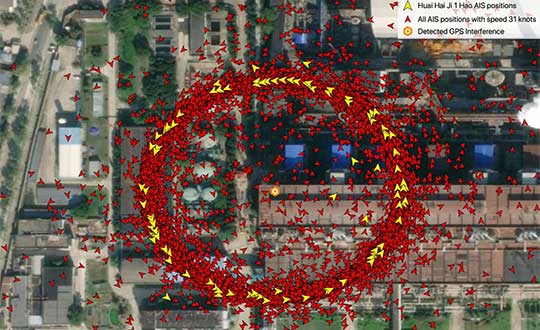
‘Spoofing circles’ appear in China
“GPS spoofing circles” have been discovered at 20 locations along the Chinese coast, according to the non-profit environmental group Skytruth. Of the locations observed, 16 were oil terminals; the others were corporate and government offices. The spoofing in Shanghai resulted in reported positions from ships, fitness trackers and other GPS-enabled devices forming circles some distance from the shore — a phenomenon first observed by the non-profit C4ADS. Professor Todd Humphreys briefed the phenomena at an Institute of Navigation conference in September, and MIT Technology Review published an article about it in November 2019.
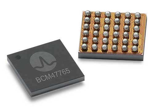
BCM4776 chip utilizes 30 new L5 signals to deliver higher navigational accuracy and yield
Photo: Broadcom
Broadcom introduced in 2017 the first mass-market implementation of dual frequency: BCM4775. This chip makes use not only of the classic L1 frequency broadcast by every satellite, but also of the more advanced L5 signal broadcast by a subset of the satellites.
The use of this enhanced L5 signal improves the accuracy of GNSS in an urban scenario, as it mitigates the main source of error: the reflections in the nearby buildings, also known as multipath. It also improves GNSS in an open-sky scenario, allowing submeter accuracy, a previously unmet performance bar in smartphones until now. Ever since, the BCM4775 has been adopted in flagship smartphones, smartwatches and fitness devices.
Given the unabated need for better precision and accuracy, Broadcom has introduced its second-generation dual-frequency GNSS solution — the BCM4776.
The new chip is capable of using the new BeiDou-3 constellation’s B2a signals (the Chinese indicator for L5). It will be able to track 30 new L5 signals (60 percent more) with a significant impact on accuracy. End users will experience much higher reliability of the submeter accuracy inherent to dual-frequency L1-L5.
Image: Broadcom
Second generation dual-frequency GNSS will be used for innovative lane-level driving navigation instructions, allowing driving applications to know which highway lane the vehicle is in. Expect instructions like “move one lane to the right so you don’t miss your next highway exit” or “move one lane to the left to take the pool lane and save 10 minutes.”
The company also announces that HERE Navigation On-Demand is OEM-ready with APCOA as partner
HERE Technologies has introduced at CES 2020 its High Definition Global Navigation Satellite System (HD GNSS) positioning, a cloud-based solution that enables mass-market devices to achieve sub-meter accuracy across the globe.
CES 2020, the massive annual consumer electronics show, is taking place Jan. 7-10 in Las Vegas. Here’s booth is at Central Plaza, Tech East.
HD GNSS enables new user experiences with lane-level navigation, augmented and virtual reality. It combines precise point positioning (PPP) and real-time kinematic (RTK) positioning methods, allowing for fast convergence time, high availability and global coverage.
It also supports off-the-shelf mobile devices and internet of things (IoT) trackers equipped with dual frequency chipsets such as the Broadcom BCM47765 and BCM47755.
Photo: HERE
More mass-market devices and vehicles are being equipped with dual-frequency GNSS receivers. With the HD GNSS service, the receivers enable high-precision positioning, HERE said, a capability that was cost and geographically prohibitive less than two years ago.
HERE HD GNSS accelerates chipset, hardware and software makers’ ability to offer a step change in what can be delivered to consumers in new product capabilities, features and user experiences, the company said.
HERE HD GNSS data delivery is optimized for mobile devices, requires no additional hardware and comes equipped with spoofing detection and phone sensor integration. It provides global coverage (including China and Japan), with single-frequency mobile device support in the future.
HERE is also working across a partner ecosystem — including reference station operators, chipset manufacturers, module makers, hardware vendors, mobile network operators and system integrators — to jointly improve the positioning accuracy to centimeter levels, and in more challenging environments such as urban canyons.
Automotive use cases
Autonomous driving. For safety, it’s critical that automated vehicles are designed with high levels of redundancy in positioning systems. If an automated vehicle gets caught in bad weather conditions which are degrading optical sensor operations, <0.2m positioning accuracy available via HD GNSS increases safety and operation time in autonomous mode.
Assisted driving. In case of an obstacle on the road, HD GNSS combined with HERE HD maps provide obstacle indication and avoidance functionality.
Mobile device use cases
Road lane guidance and improved ETAs on mobile devices. If a driver is unfamiliar with the roadway, HERE HD GNSS, combined with precision HERE map data, shows the driver the correct lane and path to navigate to the destination fast and safely.
Improved gaming and augmented reality experience. Location-based games are growing and widely popular, however they currently rely on less accurate positioning technologies that inhibit next generation use cases. HERE HD GNSS bring exciting opportunities to design the next version of games with sub-meter positional accuracy.
HERE Navigation On-Demand is OEM-ready with APCOA as partner
HERE Navigation On-Demand is now available for integration in OEM infotainment programs. APCOA Parking is the first non-automotive company to use the Service Package SDK to make its parking services available on HERE Navigation On-Demand.
HERE Technologies’ software-as-a-service solution HERE Navigation On-Demand is available for integration in OEM infotainment programs. With HERE Navigation On-Demand, OEMs and Tier 1 vendors get to deliver both connected services and expandable navigation experiences on both embedded and mobile platforms.
The connected solution cuts development and lifecycle costs by offering cutting-edge, off-the-shelf functionalities while enabling OEMs and Tier 1 vendors to use an SDK to build their own features or integrate third party services.
As a software-as-a-service offering, HERE Navigation On-Demand enables OEMs to remotely configure and monitor the deployed navigation solution making it possible to update and upgrade the experience anytime, even after the sale of the vehicle.
OEMs can further offer any functionality as a subscription option and thus generate new, recurring revenue streams. The end-user accesses the navigation experience through client software which downloads the Service Packages from the cloud.
The highly modular Service Packages include map data, software features, UX elements and references to Cloud Service APIs. Smart caching of these Service Packages ensures that HERE Navigation On-Demand also works offline.
Alexa, Amazon’s cloud-based voice service, is pre-integrated into HERE Navigation On-Demand, making it faster and easier for automakers to deliver an intuitive, voice-first navigation experience to customers in the car.
u-blox’s Bluetooth low-energy module features direction finding, bringing the benefits of high-precision positioning to indoor applications
U-blox, provider of positioning and wireless communication technologies, has announced the u-blox NINA-B4 Bluetooth low-energy module series. Based on Nordic Semiconductor’s recently announced nRF52833 chip, NINA-B4 enables a number of Bluetooth features including Bluetooth long range, Bluetooth mesh and Bluetooth direction finding.
The module is tailored to the needs of applications in the connected industry, smart homes, buildings and cities, asset tracking and eHealth.
The NINA-B4 offers a new direction-finding feature, a key component of the Bluetooth v5.1 specification that brings the benefits of high-precision positioning to indoor applications. It is the first u-blox module designed to act as both a transmitter and a receiver in angle of arrival (AoA) and angle of departure (AoD) direction finding and indoor positioning applications.
In AoA-based implementations, stationary beacons equipped with multi-antenna arrays determine the angle of arrival of signals emitted by a tracking device to pinpoint the tracker’s location with sub-meter-level accuracy. When AoD is used, the tracking device triangulates its position by calculating the angle of departure of signals from the stationary Bluetooth beacons’ multi-antenna arrays.
Mesh, long range, and extended temperature range
The u-blox NINA-B4 enables wireless mesh networks, which offer robust communication between large numbers of connected devices, extending the reach of messages by relaying them from node to node until they reach their destination. By simplifying the control of groups of devices, mesh networks are well suited for applications such as smart lighting systems in cities and buildings, which further benefit from the module’s enhanced operating temperature range (up to 105 °C).
Featuring Bluetooth long range, the NINA-B4 series can be deployed in harsh environments, for instance, to enable wirelessly connected and configurable equipment. Long range not only increases the distance that Bluetooth signals can travel in undisturbed environments, but also makes communications more robust and reliable in unfavorable ones, a common need in production plants or on factory floors.
The NINA-B4 series comes with u-blox u‑connect software, simplifying integration of Bluetooth into new and existing products by providing an easy-to-use interface to configure the connectivity required.
NINA-B4 has a powerful Arm Cortex-M4F MCU with an open CPU architecture, allowing customers to run their own applications on the module. Supporting Zigbee and Thread, the first members of the NINA-B4 family come with an internal PCB antenna, or alternatively with a U.FL connector for an external antenna of choice.
Samples of the NINA-B4 will be available in December.