Category: Mobile

  • Orolia provides improved search and rescue with ground station upgrades

    Orolia provides improved search and rescue with ground station upgrades

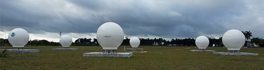
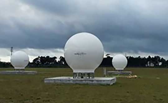
    Orolia has successfully installed the first operational Cospas-Sarsat second-generation technology on search-and-rescue ground stations for the National Oceanographic and Atmospheric Administration (NOAA) in Florida and Hawaii.

    The ground stations have been upgraded with second-generation beacon (SGB) signal-processing capabilities to more accurately and quickly locate the source of distress signals.

    The NOAA Florida and Hawaii ground stations are the only operationally ready Medium Earth Orbit Search and Rescue (MEOSAR) ground stations in the world to receive the SGB signal specification capability.

    The Cospas-Sarsat global search-and-rescue system developed specifications for the second-generation 406-MHz search-and-rescue beacon, which uses a modern, spread-spectrum signal to achieve more accurate and robust performance.

    “The work performed by Orolia was exceptional, as the process of upgrading an operational system to a higher set of requirements, years after its initial design, involves minimizing downtime while validating the new requirements and revalidating the previous requirements,” said Mickey Fitzmaurice, NOAA SARSAT Systems Engineer. “The successful result makes it obvious that the engineering and operations team at Orolia put a great deal of time and effort into planning the upgrade, as the execution was seamless.”

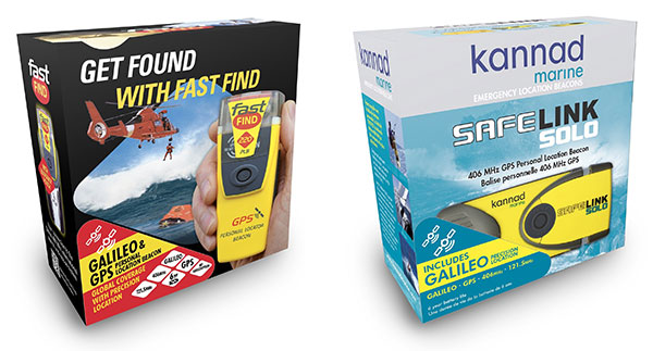
    Orolia has also launched a Galileo-enabled personal locator beacon and commissioned the first two nodal LEOSAR-GEOSAR-MEOSAR (LGM) mission control centers.

    “This series of world firsts demonstrates Orolia’s broad technical leadership in the global search and rescue ecosystem,” said Orolia Director of SARSAT Operations, Steve Ludwig. “We continually innovate to enhance the usefulness of these technologies, from generating encrypted beacon alert signals to including alert authentication through the use of Galileo Return Link Service.”

    Cospas-Sarsat ground stations are called Local User Terminals (LUTs). These satellite receiving units are the ground stations that receive emergency beacon distress alerts. (Photo: NOAA)
    Cospas-Sarsat ground stations are called Local User Terminals (LUTs). These satellite receiving units are the ground stations that receive emergency beacon distress alerts. (Photo: NOAA)
  • Did the chicken you’re eating live a happy life?

    Did the chicken you’re eating live a happy life?

    Portlandia Prediction: Fred Armisen and Carrie Brownstein have a few questions about their chicken dinner. (Screenshot: IFC)
    Portlandia Prediction: Fred Armisen and Carrie Brownstein have a few questions about their chicken dinner. (Screenshot: IFC)

    In 2011, the first-ever episode of a TV comedy called “Portlandia” debuted. In one sketch, concerned diners played by series stars Fred Armisen and Carrie Brownstein question their waitress about the origins of their chicken dinner.

    The waitress shows the couple the chicken’s papers and photo — Colin the Chicken lived a free-range life on a four-acre woodland farm only 30 miles away, dining on sheep’s milk, soy and hazelnuts, in the company of his chicken friends. Unconvinced even by these details, the couple decides to drive to the farm to see it for themselves.

    Enter GoGo Chicken

    In a case of comedy becoming reality, Chinese insurance company ZhongAn Online has outfitted more than a 100,000 chickens with GPS trackers. People who buy a chicken with a tracker strapped to its leg will know every step that that chicken has taken. Using a smartphone app called GoGo Chicken, customers can monitor the animal’s diet, exercise and environment.

    The company says its technology will be on 2,500 farms in China by next year. It is also working on facial-recognition technology so that consumers can make sure the organic chicken they saw on the farm is the same one that ends up on their plate.

    While this all sounds a bit much for many of us who grew up on Chicken McNuggets, there is a practical side. The company hopes GPS tracking will help prevent food safety problems, such as a 2014 crisis in China in which a supplier was caught selling rotting and expired meats to fast-food chains. In the event an issue does arise, the data tracked by the devices could help find the source of the problem.

  • Furuno to launch single-band GNSS receivers for 5G

    Furuno to launch single-band GNSS receivers for 5G

    Furuno Electric Co. Ltd., based in Nishinomiya, Japan, has developed the GT-88 timing module and GF-8801/02/03/04/05 disciplined oscillator for users who require UTC time-synchronized signals to meet the new 5G requirements.

    They provide UTC time-synchronized timing signals (1 PPS/10 MHz) by receiving GNSS satellite signals. Achieved stability is better than that of an atomic clock, including a rubidium.

    Photo: Furuno
    Photo: Furuno

    The GT/GF-88 series includes a brand-new algorithm, named Dynamic Satellite Selection, that provides outstanding multipath mitigation, especially in urban canyon environments, the company said. The algorithm was developed by Nippon Telegraph and Telephone Corporation (NTT) based in Tokyo, Japan.

    Extremely high stability of 4.5 ns (1 sigma) is obtained, only requiring reception of the L1 band (1575.42 MHz) frequency GNSS satellites. It was achieved by improving advanced position estimation algorithms and optimizing position calculation among several different GNSS satellite constellations. It allows users to achieve 5G-required performance without any changes to existing single-band GNSS antennas.

    It incorporates the Dynamic Satellite Selection, an advanced multipath mitigation algorithm developed by NTT. Normally typical time synchronization performance deteriorates in urban canyon environments by the effect of multipath. The Dynamic Satellite Selection reduces this time error by one-fifth. This provides more flexibility when installing GNSS antennas. Consequently, the GT/GF-88 series now permits GNSS antennas to be mounted on walls, windows of tall buildings and other difficult reception environments.

    The GT/GF-88 series continues to support GPS, GLONASS and QZSS satellite constellations, and now adds Galileo support. As the total number of satellites available increases, operational stability also increases.

  • Orolia launches Galileo-enabled personal locators in Europe

    Orolia launches Galileo-enabled personal locators in Europe

    The upgraded McMurdo FastFind 220 and Kannad SafeLink Solo Personal Location Beacons. (Photo: Orolia)
    The upgraded McMurdo FastFind 220 and Kannad SafeLink Solo Personal Location Beacons. (Photo: Orolia)

    Orolia’s McMurdo FastFind 220 and Kannad SafeLink Solo personal location beacons (PLB) now operate with the Galileo GNSS system.

    The PLBs are the first of a series of new solutions coming from the European Union-funded Helios project, led by Orolia, which has been set up to leverage the power of the new satellite system.

    With Galileo, the upgraded multi-constellation PLB receivers offer increased global coverage and support accelerated rescue missions. Location detection is enhanced and can be more precise as the PBLs receive coordinates from the Galileo satellite network in addition to GPS. Signals can even be detected in high-sided locations, such as canyons.

    “We are thrilled to be launching our upgraded PLBs in the European and U.S. markets,” said Chris Loizou, vice president of maritime at Orolia. “The combination of both Galileo and GPS GNSS capability means that our customers will benefit from coverage that spans from the North to the South Pole. We work tirelessly to push the boundaries of product innovation and, ultimately, to give people the best chance of being rescued in an emergency situation.”

    The McMurdo FastFind and Kannad SafeLink PLBs are part of Orolia’s comprehensive search-and-rescue ecosystem and join the McMurdo SmartFind G8 and Kannad SafePro series EPIRBs as Galileo-capable rescue beacons.

  • Bluetooth provides sub-1-meter location precision in new feature

    Bluetooth has added a new direction-finding feature to help meet the growing demands of the location services market.

    The feature, which allows devices to determine the direction of a Bluetooth signal, was added to Bluetooth in version 5.1 of the Bluetooth Core Specification, released Jan. 28.

    To make use of the direction-finding feature, Silicon Labs has released new software for the Wireless Gecko portfolio, a comprehensive connectivity solution for the internet of things (IoT).

    Silicon Labs’ commercial, industrial and retail customers can enhance their location-based services — indoor navigation, asset tracking, space utilization and point-of-interest engagement — using the direction-finding feature, the company said.

    The new feature supports multiple methods for determining signal direction including angle-of-arrival (AoA) and angle-of-departure (AoD).

    Silicon Labs’ implementation of the new Bluetooth feature enables detection of signal direction within 5 degrees.

    To date, Bluetooth asset tracking and indoor positioning solutions have typically provided location accuracy within a range of 3-4 meters. With the Silicon Labs Bluetooth 5.1 solution, developers can create products that improve location accuracy down to the sub-1-meter level, opening the door to applications previously not possible.

    “The Silicon Labs Bluetooth direction finding solution provides a huge leap in location services accuracy for the industry,” said Matt Johnson, senior vice president and general manager of IoT products at Silicon Labs. “The combination of the Silicon Labs wireless solution and the new features added in Bluetooth 5.1 will help developers transform industries and improve people’s lives.”

    In addition to improved location services, Bluetooth 5.1 also helps developers:

    • reduce power consumption with sleep clock accuracy updates.
    • improve smart home connection performance using GATT caching functionality.
    • optimize beaconing for Bluetooth mesh in crowded RF environments with the advertisement channel index feature.

    “The Bluetooth community continues to find ways to meet evolving market needs and open new opportunities,” said Mark Powell, Bluetooth SIG executive director. “The addition of Bluetooth direction finding demonstrates this commitment to drive innovation and support the incredible growth opportunity within the location services market.”

    Silicon Labs’ direction-finding software, including support for the AoA method, is available to customers through the Silicon Labs Simplicity Studio development kit.

  • Skyworks unveils Sky5 Ultra platform for 5G architecture

    Skyworks unveils Sky5 Ultra platform for 5G architecture

    Skyworks Solutions Inc. has launched the Sky5 Ultra, an advanced 5G cellular architecture.

    The fully integrated, baseband agnostic solution combines all of the critical front-end functionality required to enable high-performance 5G mobile devices with global coverage in a compact form factor.

    Graphic: Business Wire
    Graphic: Business Wire

    The comprehensive platform features transmit and receive capabilities with high efficiency and output power, enabling reliable network connections while optimizing battery life — both critical for 5G applications.

    In addition, the Sky5 Ultra leverages DSBGA packaging to reduce the footprint and advanced TC-SAW and BAW filtering to provide the best performance at each targeted frequency band.

    The solution also supports up to 100-MHz wide bandwidth, maximizing data throughput at ultra-fast speeds.

    5G rollouts have already begun and will continue to ramp over the next few years. According to the Global Mobile Suppliers Association, 11 worldwide operators have announced limited 5G service launches and seven additional operators have turned on 5G base stations, with commercial services to follow.

    “With industry momentum accelerating towards 5G, Skyworks is leading the way with the technological innovations and systems expertise demonstrated by our Sky5 portfolio, a highly flexible and customizable suite designed to meet customers’ global requirements,” said Joel King, senior vice president and general manager of Mobile Solutions at Skyworks.

    “Sky5 Ultra represents another breakthrough in simplifying the growing complexity of 5G device development — delivering unmatched performance while expediting deployment through full integration and optimized form factors. We are empowering top mobile device manufacturers and network providers with complete, turnkey solutions that will ultimately bring 5G to realization,” King said.

    About Sky5 Ultra

    Sky5 Ultra incorporates Skyworks’ high-efficiency transmit, diversity receive (DRx) and MIMO modules with industry-leading noise figure and low insertion loss, in addition to an array of aperture tuners and antenna swap switches for optimal antenna management.

    Like all Sky5 solutions, the comprehensive front-end platform supports new 5G NR waveforms and spectrum in addition to enhanced carrier aggregation and 4G/5G dual connectivity, while delivering exceptional levels of integration and performance. Functional core blocks include:

    Primary Transmit (Global)

    SKY5-8255 – Dual-chain N77/N79 ultra-high–band power amplifier with integrated low noise amplifier and filters (LPAMiF)
    SKY5-8254 – N41 high band power amplifier with integrated filter (PAMiF)
    SKY5-8265 – Mid-/high-band power amplifier with integrated low noise amplifier and duplexers (LPAMiD) with DSBGA packaging
    SKY5-8211 – Low-band LPAMiD
    SKY5-8212 – Low-band LPAMiD with DSBGA packaging
    SKY77365 – Global system for mobile communications (GSM) power amplifier

    Connectivity (GPS, Wi-Fi, Bluetooth)

    SKY65725-81 – Shielded GPS module
    SKY65728-11 – L5 shielded GPS module
    SKY85819-11 – WLAN/GPS antenna share module
    SKY85817-11 – Dual-band LAA/WLAN module
    SKY85774-11 – 5 GHz LAA/WLAN module

    5G Diversity/MIMO (Global)

    SKY13725 – Low band DRx module with DSBGA packaging
    SKY13726 – Mid/High band DRx module with DSBGA packaging
    SKY13727 – Mid/High band MIMO module with DSBGA packaging
    SKY5-3728 – Ultra high-band N77/79 DRx/MIMO module with SRS support

    Antenna Management

    SKY5-9269 – SP4T 80v aperture tuning and RF distribution switch
    SKY5-9256 – 4 x SPST 45v aperture tuning switch
    SKY5-9699 – DPDT antenna swap switch

    At Mobile World Congress, Skyworks representatives are in the Executive Meeting Area in Hall 2, 2G3Ex and 2G5Ex.

  • Skyhook to provide location service protections to Rivetz network

    Skyhook to provide location service protections to Rivetz network

    Image: iStock/hanibaram
    Image: iStock/hanibaram

    Skyhook is partnering with Rivetz to integrate Skyhook’s global mobile location services to enhance the Rivetz platform.

    Skyhook is the operator of a worldwide independent location services platform. The company’s technology provides the foundation for mobile location services in the global market for connected devices.

    Skyhook’s hybrid positioning system locates devices using observed radio signals — including GNSS, Wi-Fi and cellular — ensuring that all devices can be located in all environments.

    Rivetz offers decentralized, embedded cybersecurity tools.

    By enabling Skyhook’s advanced location capabilities on the Rivetz Network of cybersecurity tools, Rivetz users can take advantage of location service protection in any signal environment, regardless of GPS availability.

    Accurate and accessible device location services are a critical component of all end-to-end security solutions, particularly in regulated environments or other markets where trusted and verifiable location is a requirement.

    “We are pleased to partner and collaborate with Rivetz, a trusted leader in decentralized mobile security,” said Kipp Jones, Chief Technology Evangelist of Skyhook. “We share the values that our products must be built on the pillars of trust and respect for individual privacy. We look forward to providing Skyhook’s industry-leading location services to the Rivetz Network.”

    “We are proud to join forces with Skyhook to enable powerful location services to the Rivetz Network,” said Steven Sprague, co-founder and CEO of Rivetz. “A simple and safe security model is our greatest priority, and precise device location is a cornerstone of protecting our cybersecurity solutions.”

    Rivetz’s security solutions hinge upon access to the Trusted Execution Environment (TEE), which is an isolated, measured computer environment separate from the operating system. By provisioning all digital transactions through the TEE, Rivetz assures that users’ private keys cannot be altered or stolen if the operating system were tampered with or infected by malware.

  • Rohde & Schwarz and Bluetest partner on A-GNSS OTA antenna testing

    Rohde & Schwarz and Bluetest partner on A-GNSS OTA antenna testing

    Testing the antenna performance of GNSS signals such as GPS, GLONASS, Beidou, Galileo and Metropolitan Beacon Systems (MBS) is key to location accuracy performance of a mobile device.

    To address the testing need for A-GNSS services, Rohde & Schwarz and Bluetest are partnering in creating test concepts for over-the-air (OTA) antenna measurements.

    The CMW500 wideband radio communication tester. (Photo: Rohde & Schwarz)
    The CMW500 wideband radio communication tester. (Photo: Rohde & Schwarz)

    The two companies integrate the R&S LBS Server, a software component running on the R&S CMW500 wideband radio communication tester, and the Bluetest OTA test solution for A-GNSS systems based on Bluetest’s RTS65 reverberation chamber and Bluetest’s Flow measurement software.

    In the test setup, the R&S LBS Server controls the Rohde & Schwarz base-station simulator R&S CMW500 for LTE, WCDMA and GSM, and uses the R&S SMBV100B vector signal generator for simulation of GNSS and MBS signals.

    A simple and straightforward upgrade of the setup for 5G will be available soon, making sure that investments are protected and most relevant standards can be tested with the same system.

    The R&S LBS Server is an essential part of the R&S TS8991 OTA Performance Test System. This cooperation between Rohde & Schwarz and Bluetest marks the first time that the R&S LBS Server, used here as a software tool on R&S CMW500, is available also for third parties.

    “We are delighted to collaborate with Bluetest to contribute with our test and measurement expertise to OTA 4G/3G/GSM and GNSS technology development,” said Alexander Pabst, vice president, Systems and Projects at Rohde & Schwarz. “With a strong global footprint for location based services LBS and close cooperation with partners, Rohde & Schwarz is committed to accompanying the evolution path from OTA testing for GPS, GLONASS, BeiDou and Galileo with innovative test and measurement solutions.”

    “The addition of A-GNSS measurements means that the full range of wireless technology in a modern cellular device can be verified with just one test solution,” said Robert Rehammar, Bluetest CTO. “Bluetest has enjoyed the close cooperation with Rohde & Schwarz on this project, leading to a very strong joint solution and customer offering.”

  • Nurlink launches GNSS and NB-IoT system on chip

    Dragonfly (Image: CEVA)
    Dragonfly (Image: CEVA)

    CEVA Inc. and Nurlink have introduced Nurlink’s NK6010 3GPP Rel.14 eNB-IoT system-on-chip (SoC), powered by the CEVA-Dragonfly NB2 IP solution.

    The companies made the announcement in advance of Mobile World Congress, which takes place Feb. 25-28 in Barcelona, Spain.

    According to the companies, NK6010 is a cost- and power-efficient NB-IoT system on chip (SoC) designed specifically to enable narrowband connectivity in massive internet of things (IoT) devices such as smart meters, wearables, asset trackers and industrial sensors.

    The SoC, built around the CEVA-Dragonfly NB2 solution, incorporates an RF front-end, RF transceiver, cellular baseband, power management unit and application processor, all highly integrated to minimize the size and cost of the device.

    The SoC includes an extremely low-power multi-GNSS subsystem, supporting GPS/Beidou/Galileo/GLONASS global navigation systems, to ensure highly-accurate device tracking and locating, worldwide, the companies said.

    It also supports all NB-IoT frequency bands and major global carriers, ensuring smooth and rapid certification of devices on any NB-IoT commercial network around the world.


    The CEVA-Dragonfly NB2 IP solution is a modular technology, composed of the CEVA-X1 IoT processor, an optimized RF transceiver, baseband, and a protocol stack to offer a complete Release 14 Cat-NB2 modem IP solution that significantly reduces time-to-market and lowers entry barriers.

    It is a fully software-configurable solution and can be extended with multi-constellation GNSS and sensor fusion functionality. The IP includes a reference silicon of the complete modem design, including an embedded CMOS RF transceiver and PA, an advanced digital front-end, physical layer firmware and a protocol stack (MAC, RLC, PDCP, RRC, and NAS).

    “We developed NK6010 to meet the exceptional demand for NB-IoT chipsets to power the multitude of new use cases and applications that narrowband cellular connectivity serves,” said Xiaohua Kong, Nurlink CEO. “The CEVA-Dragonfly NB2 enabled us to massively accelerate our time-to-market by providing many of the key building blocks for our SoC design, already silicon proven and pre-integrated.

    “In addition, through the programmable nature of the Dragonfly solution, our engineering team were able to add our innovation during the communication system development and SoC customization,” Kong said. “This framework eventually helped us to create a truly differentiated product. Our path from licensing to silicon was achieved in under one year, and we’re now engaged with operators worldwide to certify our SoC.”

    “NB-IoT has reached critical mass, with more than 60 operators around the world already supporting the standard and dozens more launching coverage imminently,” said Michael Boukaya, vice president and general manager of the wireless business unit at CEVA. “Now the drive towards ultra-low cost NB-IoT chipsets and modules has begun and Nurlink, powered by our CEVA-Dragonfly NB2 IP solution, is one of the early entrants into this fast growing space. We applaud their efforts to reach the market so quickly and look forward to monitoring their success.”

  • Luggage that uses GPS to follow you

    Chinese company Forward X Robotics showed off its Ovis luggage at the 2019 Consumer Electronics Show.

    Ovis uses cameras for facial recognition and a movement tracking algorithm to lock in on its owner and stick with her or him at a speed of six miles per hour. Ovis is able to avoid collisions as it makes its way through crowds, according to its maker, which is now producing the suitcase after an IndieGoGo campaign.

    Image: Forward X Robotics
    Image: Forward X Robotics

    The Ovis suitcase comes with a smart wristband that sounds and vibrates if the case gets more than six feet away. Its embedded GPS provides real-time monitoring and tracking via smartphone; the location tracker is in an uncuttable luggage tag.

    Similar following suitcases include 90Fun’s Puppy 1, which uses remote control to follow, and the Travelmate Robotics, which provides a removable GPS chip to enable tracking of the bag or anything else of value.

  • No-charge GNSS smartwatch uses u-blox technology

    No-charge GNSS smartwatch uses u-blox technology

    Photo: u-blox
    Photo: u-blox

    U-blox, a global provider of positioning and wireless communication technologies, is partnering with TransSiP and Matrix Industries to create PowerWatch 2, a GPS smartwatch that doesn’t need to be charged.

    The smartwatch features the ultra-small, ultra-low power u-blox ZOE-M8B GNSS receiver to track position, in addition to calories burned, activity level, and sleep, making it an ideal companion for runners, hikers, and swimmers. All this is enabled by TransSiP PI technology which ensures energy harvested is used at maximum efficiency and provides crystal clean power enabling optimum performance.

    The PowerWatch 2 does away with cables and external batteries by continually topping up its battery using thermoelectric energy generated from body heat as well as solar energy. The watch also connects to smartphones and displays notifications on your wrist, tracks activities and visualizes them using dedicated iOS and Android apps, as well as with popular third party health and fitness platforms.

    The PowerWatch 2 delivers location tracking using the low-power u-blox ZOE-M8B GNSS receiver module that consumes as low as 12 mW. Packaged as a (System-in-Package), the 4.5 x 4.5 x1.0 mm module helps achieve the watch’s comparatively low 16-mm thickness. And concurrent reception of up to three GNSS constellations means that it delivers high accuracy positioning in challenging situations such as urban or dense forest environments and when swimming.

    Satellite-based positioning is typically the most power-hungry process on a sports watch. Providing highly efficient conversion of harvested energy into a very quiet supply of DC power, TransSiP PI enhances the ability of the ZOE-M8B GNSS receiver module incorporating u-blox Super-E technology, to strike an ideal balance between power and performance. Working on a tight power budget, the watch supports 30 minutes of continuous GNSS tracking per day, with unused time accumulating in the watch’s battery pack, such as powering two hours of location tracking every four days.

    “We put a lot of effort into tailoring the ZOE-M8B to the needs of small battery powered applications. We couldn’t have wished for a better product to showcase our ZOE-M8B’s potential for wearables than the PowerWatch 2,” says Florian Bousquet, principal product manager in Standard Precision GNSS at u-blox.

    Douglas Tham, CTO of Matrix Industries added, “TransSiP PI makes it possible to deliver high performance and high efficiency simultaneously by reducing system noise, eliminating time spent re-acquiring data, and minimizing the need for additional processing. This means power savings across-the-board and enables applications which can be powered solely by energy harvesting.”

    “Not only were size, cost and power constrained in developing the PowerWatch 2, we also had to make sure that it met the high performance demands that athletes expect,” said Akram Boukai, CEO and co-founder of Matrix Industries. “The combination of TransSiP PI and the ZOE-M8B solved all of these pain points for us, enabling the watch to quickly lock in on its position even in weak signal environments.”

    Backers of the project on Indiegogo are expected to receive their orders in June 2019.

  • 4G LTE-M personal tracker offered by WTS Positioning

    4G LTE-M personal tracker offered by WTS Positioning

    Photo: WTS Positioning Solutions
    Photo: WTS Positioning Solutions

    WTS Positioning Solutions, a Swedish GPS tracking company, has released its next generation of smart GPS trackers: the Trax G+ series.

    At the top of the range is Trax G+ 4G LTE-M, one of the first LTE trackers commercially available on the market, the company said. It supports 4G LTE-M and NB-IoT standards, with both European and U.S. models available.

    WTS has also released two new, improved GPS models using 3G and 2G standards, to complete the new Trax G+ range.

    Trax G+ tracker.  Trax G+ is a small GPS tracker for personal use. It has real-time tracking capability with update rates of up to every 10 seconds. For customised industrial applications, the new Trax G+ can support up to two updates per second. It also comes with wireless charging and IP68 water resistance.

    The Trax G+ App, available in the App Store and Google Play, has a wide range of features including Unlimited Geofences, Augmented Reality Tracking, Speed Alerts, Location History, the possibility to track multiple devices and device sharing.

    WTS works closely with brands across several consumer markets, including sports gear, event management, security, search and rescue, homecare and telecommunications.

    Photo: WTS Positioning Solutions
    Photo: WTS Positioning Solutions

    Tracking vest. A special collaboration with POC sports brand, manufacturer of helmets, body armour and sports apparel, resulted in an ISPO Gold Winner award for the POCito VPD Air Vest + TRAX POC edition.

    The vest provides a child with back protection for winter sports and is designed to store a TRAX POC Edition device. It is an integrated protection, alert and tracking system that allows parents to monitor and keep children safe on the slopes.

    POC will present the vest at ISPO Munich, held Fe.b 3-6, in Hall B6, Booth 414.

    Trax G+ data plans are offered in 6-, 12- and 24-month pre-paid packages and offer international coverage and free roaming in all supported countries.

    WTS Positioning Solutions are specialists within the GNSS industry, supplying personal GPS trackers, plus customised hardware, software, server and data solutions for high-precision real-time location and tracking information.