Category: Mobile

  • Rugged tablet purpose-built for high-accuracy measurements

    Rugged tablet purpose-built for high-accuracy measurements

    RealSense 3D camera is fully integrated to capture real-time detailed images

    DT301X rugged tablet. (Photo: DT Research)
    DT301X rugged tablet. (Photo: DT Research)

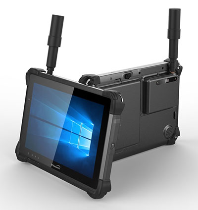
    DT Research has released the DT301X rugged tablet, a lightweight military-grade tablet that is purpose-built to enhance the precision of crime and crash scene reconstruction, bridge and other construction inspections, and 3D surveying.

    DT Research made the announcement at Intergeo, being held Oct. 16-18 in Frankfurt, Germany.

    The DT301X rugged tablet has MIL spec and IP ratings, yet is lightweight — offering the versatility to be used in the field, office and vehicles, the company said. A high brightness 10.1-inch touchscreen offers flexible viewing in a wide range of lighting, and an Intel eighth-generation Core i5 or i7 processor offers high-performance while still being energy-efficient.

    With high-capacity 60- or 90-watt hot-swappable batteries, the DT301X keeps working continuously, complemented with a variety of battery chargers so fully-charged batteries are always available.

    The DT301X integrates the Intel RealSense depth camera, which provides real-time 3D imaging to shorten the workflow and create extremely accurate measurements for CAD, engineering, design, utility management and crime-scene forensics.

    Scientific grade data, which is important for court evidence as well as building plans, just got easier and is now available to a wider group of workers. With this 3D camera technology, depth perception is integrated to add the most accurate image to make projects stay factual and consistent, DT Research said.

    Optional data capture offered on the DT301X besides the 3D camera are a 2D barcode scanner for equipment/location tags, a dual-frequency GNSS module for real-time mapping and positioning, long-range Bluetooth for 1000-foot range, and 4G LTE mobile broadband for the latest in high speed communications.

    The rugged tablet gives detailed accuracy combined with the latest 3D camera technology all in one device that is rugged and easy to use in the field.

    “DT Research’s high-performance rugged tablet equipped with the RealSense depth camera combined with DotProduct’s Dot3D Scan software allows speedy and efficient field-to-office 3D workflows for a wide range of applications from construction verification to asset management to crime scene mapping,” said Tom Greaves, chief marketing officer at DotProduct.

    The DT301X is built to operate in real-world situations, with an IP65 rating for water and dust, MIL-STD-810G for shock and vibration protection, and MIL-STD-461F for EMI and EMC tolerance. The tablet can be paired with a detachable keyboard for ease of use, and Wi-Fi and Bluetooth for smooth networking and constant communications.

    The DT301X rugged tablet is compatible with existing applications with Microsoft Windows 10 IoT Enterprise operating systems for flexible integration, and it brings together the advanced workflow for data capture, accurate positioning and data transmitting.

    Whether at the electrical substation, at the crash scene, or at the construction site, the DT301X is ideal for accurate measurements as well as other needed tasks, able to travel to wherever the work is.

    The DT301X rugged tablet will be available in November 2018 from DT Research’s authorized resellers and partners.

  • Garmin’s latest watch features GPS, GLONASS and Galileo

    Garmin’s latest watch features GPS, GLONASS and Galileo

    Garmin is now offering a GPS, GLONASS and Galileo watch called Instinct. Instinct is a strong and durable watch with GNSS support, plus built-in 3-axis compass, barometric altimeter and wrist-based heart rate sensor.

    The watch includes a built-in sports apps, smart connectivity and wellness data.

    Photo: Garmin
    Photo: Garmin

    “We are thrilled to add Instinct to our adventure watch lineup, an approachable smartwatch that is rugged and reliable,” said Dan Bartel, Garmin vice president of global consumer sales. “Instinct is perfect for those who spend their time outdoors and demand a device built tough to stand up in the elements.”

    The Instinct is built to endure challenging environments, constructed to military standards (MIL-STD-810G) for thermal, shock and water resistance (rated to 100 meters) with a fiber reinforced polymer case. The chemically strengthened and scratch-resistant display is readable in direct sunlight, and the fully vented silicone bands include two independent, removable keeper loops to ensure a secure fit.

    The multi-GNSS feature helps users track their location in challenging environments. The Garmin Explore app helps plan the trip in advance, and the TracBack feature can navigate the same route back to the starting point.

    The built-in heart-rate sensor helps monitor heart rate, steps taken, distance traveled, calories burned and more.


  • Spireon launches GoldStar Connect for auto dealers, lenders

    Mobile app creates new connections for the vehicle finance industry and extends the value of GPS to consumers.

    Image: Spireon
    Image: Spireon

    Spireon Inc., the vehicle intelligence company, has introduced GoldStar Connect, a full-featured connected car mobile application that gives Buy Here Pay Here (BHPH) dealers and lenders the opportunity to increase customer loyalty and profitability.

    As the newest addition to the GoldStar GPS solution suite, GoldStar Connect helps dealers and lenders recoup the cost of GPS, while also increasing value, convenience and safety for consumers, the company said.

    The BHPH sector has long used GoldStar GPS to mitigate risk. Dealers and lenders rely on GoldStar to stay connected to their customers in order to facilitate payment collection, monitor default predictors, and streamline recoveries when necessary.

    With the new GoldStar Connect mobile app, consumers now have access to all the benefits of connectivity — real-time location access, trip history, vehicle health alerts and recovery solutions for stolen cars — as an add-on at the time of purchase, the company added.

    “In marrying the GoldStar solution with a consumer-facing mobile app, our dealer and lender customers not only improve asset management and protection, but also can offer their consumers a significant value add — modern connected car benefits regardless of the vehicle make, model and year,” said Reggie Ponsford, senior vice president of sales at Spireon. “We have had a number of larger BHPH dealers piloting the GoldStar Connect solution in the past few months and seeing up to 90 percent consumer sell-through.”

    With GoldStar Connect, consumers gain a host of added benefits with their car purchase, including:

    • Safety and Security. GPS tracking and geofencing capabilities enable consumers to know the location of the vehicle at all times, helping to ensure the safety of the vehicle and the driver
    • Trip History. provides visibility to the activity of the vehicle by date, time and duration
    • Smart Alerts. consumers receive notifications of speeding, geofenced locations and battery condition directly to their mobile devices
    • Stolen Vehicle Recovery. an in-app recovery guide provides vehicle location data and instructions to assist in reporting and recovery of a stolen car
    • Insurance Discounts. Many carriers provide discounts of up to 15%

    “Consumers want connected vehicle features and benefits, and the app helps dealers and lenders build customer loyalty while also driving additional revenue and margin,” continued Ponsford. “By bundling the purchase into the vehicle loan, it’s seamless and easy for dealers and buyers.”

    “We’re excited to help our customers in the vehicle finance industry evolve their thinking about GPS from solely managing risk to now providing an opportunity to increase consumer loyalty and profitability,” said Brian Deeley, director of product management at Spireon. “The GoldStar solution is trusted by more BHPH dealers than all of our competitors combined. The addition of GoldStar Connect creates even more distance between Spireon and the rest, maintaining GoldStar as the GPS gold standard for BHPH.”

    GoldStar Connect is now available and will be demonstrated in booth #208 at the National Alliance of Buy Here, Pay Here Dealers (NABD) Buy Here Pay Here Subprime Conference, Oct. 8-10, at the MGM Grand in Las Vegas. To book a demonstration at the conference, see Spireon at NABD.

  • Research Online: A way to monitor LTE signals for autonomous vehicles

    Integrity Monitoring of LTE Signals of Opportunity-Based Navigation for Autonomous Ground Vehicles

    By Mahdi Maaref, Joe Khalife and Zak M. Kassas/University of California, Riverside

    FIGURE 1. RAIM framework for LTE-based navigation without GNSS signals. (Images: Authors)
    FIGURE 1. RAIM framework for LTE-based navigation without GNSS signals. (Images: Authors)

    Proprietary receivers and navigation frameworks for autonomous ground vehicle (AGV) navigation with long-term evolution (LTE) cellular signals demonstrate meter-level accuracy with standalone LTE signals and lane-level accuracy with LTE signals coupled with other sensors (inertial and lidar).

    As the number of systems that rely on cellular signals for navigation grows, the need for monitoring the integrity of their navigation solution becomes essential.

    This paper proposes a receiver autonomous integrity monitoring (RAIM) framework for AGV navigation with LTE signals of opportunity. Experimental results evaluate the efficacy and accuracy of the proposed RAIM-based fault detection and exclusion technique, demonstrating a reduction of 22% in the position root-mean-squared error (RMSE).

    FIGURE 1 demonstrates the RAIM framework: (a) When GNSS signals are unusable, LTE signals are used for navigation and integrity measures are calculated; (b) simulation results of downtown Riverside, California, where the black regions represent areas where multipath is expected to exceed 0.5 meters; (c) experimental setup; (d) environment and location of LTE towers; and (e) experimental results showing severe multipath being autonomously detected and excluded.

    The estimation error represents the difference between the ground truth from an RTK GNSS-IMU system and our LTE-IMU system.

    More information available via www.aspin.ucr.edu and www.ion.org/publications/browse.cfm.

  • ESA launches new Galileo app competition

    ESA launches new Galileo app competition

    European students and researchers are invited to compete in a new Galileo smartphone app competition sponsored by the European Space Agency (ESA).

    The goal is to develop an app capable of performing fixes using raw Galileo satnav measurements. An earlier Galileo smartphone app competition has already resulted in the winning app becoming publicly available.

    This year’s event challenges teams to make use of the dual-frequency capability of the latest Android 8.0 smartphones, to compute dual-frequency positioning solutions from raw satnav signals to compare them with their single frequency equivalents.

    The competition is run by ESA in collaboration with the European Global Navigation Satellite Systems Agency (GSA) plus the European Commission with the support of Google.

    The Galileo app competition is open to all students from European universities and trainees in posts at European research and development organizations.

    “The inaugural Galileo smartphone app competition was open solely to ESA graduate trainees, but the response was so great that this time we have opened up to students and young researchers across Europe, forming teams of three to five people,” explained ESA Galileo Services Engineering Manager Rafael Lucas Rodriguez.

    The set objective is to reach sub-meter accuracy worldwide in unobscured sky conditions. The app should allow the user to select Galileo-only positioning, GPS-only positioning and the combination of both on a simultaneous basis, with the potential to include other satnav constellations in turn.

    The receiver chipsets inside smartphones routinely make use of Galileo in combination with several other satnav constellations — the U.S .GPS, Russian GLONASS and Chinese BeiDou. These chipsets function in “black box” style, making the resulting positioning fixes accessible to users, but without giving any option to the user to select which constellation to employ — or information on Galileo’s particular contribution to the phone’s overall positioning performance.

    However, in newer Android smartphones it has become possible to access the raw signal measurements used to compute position, opening the door to the development of applications where the user can indeed select which constellations to employ.

    The very latest models also allow the use of dual satnav frequencies, giving a major boost to positioning precision. The higher chip rate of the additional frequency allows the chipset to compensate for signal propagation errors from the signals’ journey through the ionosphere — the electrically active outer layer of atmosphere — and reduces false ‘multipath’ detections caused by signals reflecting off buildings.

    “As a first step, teams submit a proposal of not longer than 20 pages, summarizing the application to be developed,” explained ESA navigation engineer Nityaporn Sirikan. “These proposals will be evaluated by a jury composed of representatives of ESA, GSA, the EC and Google, with the top five proposals selected to develop their app further, receiving on loan a state-of-the-art dual frequency satnav smartphone and receiving general guidance and technical support.”

    The competition launched on Sept. 24; teams are invited to submit their proposals to [email protected] by Nov. 12, and will be informed of the jury’s response to their proposal by Nov. 26. The competition final is scheduled for April 18, 2019, at ESA’s ESTEC technical centre in Noordwijk, the Netherlands. Terms and conditions of the competition are posted here.

    The first- and second prize-winning teams will win attendance to the ESA and EC International Summer School on Global Navigation Satellite Systems in Portugal. Additional prizes will be available to the most innovative app and the winner of a public online vote, to be undertaken during the final.

  • Rx Networks provides assistance GNSS data tailored for IoT devices

    Rx Networks provides assistance GNSS data tailored for IoT devices

    Rx Networks logoRx Networks Inc., a mobile location technology and services company, has announced an update of its location.io platform to provide GNSS assistance data to enable better positioning in internet of things (IoT) devices.

    The company has updated its location.io HTTP interface to provide real-time GNSS ephemeris data with a reduced payload, a smaller predicted GNSS ephemeris client while maintaining full featured accuracy.

    Rx Networks is demonstrating location.io at its booth at ION GNSS+, being held this week in Miami.

    The location.io HTTP interface is now leaner and requires fewer requests and less data. In providing an interface for IoT devices, specifically, Rx Networks extends the delivery of their reliable and accurate assistance data to new and emerging use cases.

    “Rx Networks is a proactive company endeavoring to provide excellent solutions and services for our customers,” said John Carley, director of sales and product strategy at Rx Networks. “By adding another use-case focused interface, we are able help customers create top-quality solutions targeted for their customer needs. By adding another interface designed for specific use cases, we help our customers create top-quality solutions targeted for their customer needs. Especially in the areas of smaller processors, longer product life time and lower battery consumption.”

    location.io includes technologies already used by more than 1 billion smartphones, laptops and wearables worldwide. Specific components are:

    • Real-time GNSS assistance. The real-time assistance service is designed to work with all popular location servers such as Ericsson, TCS, ZTE, and Qualcomm. Rx Networks also offers RINEX files and a generic HTTP interface for independent access to the assistance data. It supports over five constellations, including GPS, GLONASS, Beidou, Galileo, QZSS and SBAS. RT-GNSS assistance can now be filtered by location or Cell ID to provide only Satellites in View.
    • Predicted GNSS assistance. The predicted service provide seed data that enable client devices such as smartphones, laptops, and wearables, to generate up to 14 days of extended ephemeris for fast and sensitive GNSS fixes. Predicted GNSS assistance support GPS, GLONASS, BeiDou and Galileo, and has been updated to have a smaller footprint, use less resources and support OSs and RTOSs.

    All location.io services are delivered from Rx Networks’ geo-redundant and cloud-based service delivery network, via a lean API ensuring a 99.999 percent service level availability.

    NTRIP Data. Rx Networks has also added NTRIP-formatted data services to location.io. Customers can now choose from a variety of data formats, including Rx Networks proprietary format, NTRIP, LPP, RRLP, proprietary real-time, IoT-optimized and a few custom formats.

    Observation data from our multiband multi-constellation global reference network is now available in NTRIP format, and customers are already on board.

    High availability is assured with geographically redundant secure NTRIP casters, the company said. The innovative High Accuracy Assistance Service (HAAS) product will also be available in RTCM format via NTRIP casters.

    With the addition of RTCM formatted data via an NTRIP data feed, Rx Networks continues to expand its constellation support with the largest variety of terrestrial delivery mechanisms. The solution architecture includes an NTRIP server, caster and client, providing a complete solution.

    “Our customers love the reliability and plug-and-play convenience of our NTRIP service,” said Brian Marciniak, head of business development at Rx Networks. “With Rx Networks’ expanded reference network, secure NTRIP observations and real-time data, we are enabling our customers to expand their businesses in exciting new ways.”

    location.io includes technologies already in use by more than 1 billion smartphones, laptops and wearables worldwide.

    All location.io services are delivered from Rx Networks’ geo-redundant and cloud based service delivery network.

  • HERE, Altair Semiconductor partner on IoT tracking

    HERE, Altair Semiconductor partner on IoT tracking

    Photo: Altair
    Photo: Altair

    HERE Technologies and Altair Semiconductor are partnering to integrate HERE tracking and positioning software into Altair’s ALT1250 dual-mode LTE Cat-M1/NB-IoT chipset. This will enable HERE customers, system integrators and tracking device manufacturers to significantly reduce device time to market and provide hardware-based security.

    The two companies plan to reduce overall power consumption of an end-to-end tracker application by optimizing the way the device communicates with the cloud.

    The ALT1250 includes a GNSS receiver, an RF front-end supporting all commercial LTE bands within a single hardware design, a hardware-based security framework and an internal application MCU subsystem.

    The integration of HERE tracking and positioning software means the chipset will be able to locate itself using the strength of cellular signals, even when it is not possible to obtain a GNSS fix.

    The chipset can take advantage of the ability of HERE to provide online and offline positioning based on its database of cellular towers.

  • New Garmin GPS handheld logs raw measurements in RINEX

    New Garmin GPS handheld logs raw measurements in RINEX

    Photo: Garmin
    Photo: Garmin

    Garmin International is offering a new outdoor GPS handheld that can log raw measurements in RINEX form, the GPSMAP 66

    “We’ve had good success achieving carrier-phase ambiguity resolution with the unit, and I suspect many readers will be interested in this feature from a purpose-built device,” said Jared Bancroft, GNSS sensors & algorithms, Garmin, in an email to GPS World. “We’ve observed accuracies down better than 30 centimeters.”

    The GPSMAP 66 is a premium outdoor handheld with expanded wireless connectivity, direct-to-device access to BirdsEye satellite imagery and a 3-inch sunlight-readable color display. The handheld comes in two models, the GPSMAP 66s and GPSMAP 66st. The latter offers preloaded topographic maps for U.S. and Canada.

    Professionals and serious GPS enthusiasts will appreciate the inclusion of RINEX data logging, which allows for sub-meter accuracy of GPS position after post processing, Garmin stated in a press release.

    “The GPSMAP 66st builds on the GPSMAP series heritage by adding new and requested features like a bigger screen, weather forecasting and easy direct-to-device access to satellite imagery,” said Dan Bartel, Garmin vice president of global consumer sales. “Between multi-GNSS network support and connectivity to the new Garmin Explore app, the new GPSMAP 66s and the GPSMAP 66st are reliable companions for any adventure.”

    The handheld can receive weather updates for real-time forecast information by being paired via Bluetooth to a compatible mobile device. It will also provide predictive maps for temperature and wind speed/direction, as well as live weather radar.


    Other new GPSMAP 66s/st connected features include Geocaching Live and compatibility to the Connect IQ platform, giving users access to 9 million trails through the preloaded Wikiloc app. The devices all pair with the inReach Mini, allowing the user to send and receive messages directly on their 66s/st device via the Mini.

    Between the multi-GNSS satellite support and  altimeter, barometer and compass sensor capabilities, the GPSMAP 66s/st will track an entire journey. The handheld devices have 16 hours of battery life in full GPS mode and can track the user’s position for up to one week using Expedition mode on a single set of AA batteries, the company said.

    The devices include an LED flashlight and SOS beacon that can be used to signal for help. It is built to military standards for thermal, shock and water performance (MIL-STD-810G).

  • Network-free location tracker features u-blox GNSS receiver

    Photo: LynQ
    Photo: LynQ

    U-blox is collaborating with LynQ, which developed a location tracker that doesn’t use cellphones, networks, apps or monthly fees. By syncing up the devices before heading out, group members can find each other within a five-mile radius and link up again.

    LynQ surpassed its fundraising target on the Indiegogo crowdfunding platform, raising more than $1.5 million, and is now on pre-sale.

    The device uses the u-blox CAM-M8Q GNSS receiver, a GPS/GLONASS/BeiDou positioning module with an embedded antenna. With its slim size of 9.6 x 14 x 1.95 millimeters, it is easy to integrate it into handheld devices, u-blox said.

    The first generation of the weather-proof tracker uses long-range, low-power radio frequencies to connect devices. Up to 12 people can join a group, split up, and use the only button on the clip-on device to toggle through the group members and find out in which direction and how far away each one is.


    LynQ’s crowdfunding success shows the extent to which the company’s founders uncovered an unmet demand on the market. While smartphone-based solutions to locate friends and family, for instance in a crowd, abound, they are limited by the availability of mobile network reception.

    LynQ’s location tracker helps friends regroup outdoors or at crowded events, parents keep an eye on their children, and caregivers watch over the safety of people with special needs, elderly family members, or loved ones suffering from diseases such as Alzheimer’s.

    The tracker has been field-tested on numerous continents and in most topographies and use cases.

    “We found the u blox CAM-M8Q to be the best solution for us to achieve the requirements our use cases demand,” said Drew Lauter, COO at LynQ. “We’re extremely price sensitive, yet we need a highly dependable GPS module; u-blox worked closely with us to deliver that.”

    For u blox, accompanying LynQ in the development of its product has been an exciting adventure, said Suresh Ram, president of u-blox America. “We’re thrilled to see how well their idea has been received by the public and look forward to our continued collaboration in the future.”

  • Quectel launches IoT module supporting Qualcomm location tech

    Quectel launches IoT module supporting Qualcomm location tech

    Quectel Wireless Solutions, a global supplier of internet of things (IoT) modules, has launched the EG18, an LTE Category 18, high-speed module that offers 1.2Gbps downlink and 150Mbps uplink peak rates.

    EG18 module. (Photo: Quectel)
    EG18 module. (Photo: Quectel)

    The EG18 supports Qualcomm IZat location technology Gen8C Lite (GPS, GLONASS, BeiDou, Galileo and QZSS). The integrated GNSS greatly simplifies product design, and provides quicker, more accurate and more dependable positioning capability, Quectel said.

    Based on Qualcomm’s SDX20 chipset and fully compliant with 3GPP R12 specification, EG18 supports wireless technologies such as carrier aggregation (CA), 4×4 multiple-input multiple-output (MIMO) technology and 256QAM.

    Quectel EG18 is a series of LTE Advanced modules optimized specially for M2M and IoT applications which support industrial operating temperature range of -40 to 85˚C.

    The EG18 is designed for ultra-high-speed industrial routers, in-vehicle video surveillance systems, cloud-based 4K IP-cameras and other applications that require very high throughput and low latency.

    EG25-G module. (Photo: Quectel)
    EG25-G module. (Photo: Quectel)

    EG25-G module. Quectel also launched an LTE Cat 4 module to provide global connectivity on up to 30 bands with LTE, 3G and 2G coverage all from a single SKU. This “all-in-one” module EG25-G is designed to improve the efficiency of global IoT deployment at optimized cost.

    EG25-G is the latest addition to Quectel’s comprehensive LTE portfolio based on Qualcomm MDM9x07 chipset. Adopting the 3GPP Release 11 LTE technology, it delivers 150 Mbps downlink and 50 Mbps uplink peak data rates, with an optional GNSS receiver including GPS, GLONASS, BeiDou, Galileo and QZSS to provide quick and accurate positioning, the company said.

    The new module supports FDD LTE frequency bands of B1/B2/B3/B4/B5/B7/B8/B12/B13/B18/B19/B20/B25/B26/B28, TDD LTE bands of B38/B39/B40/B41, WCDMA bands of B1/B2/B4/B5/B6/B8/B19 and quad-band GSM/EDGE. This ensures devices with EG25-G inside can operate on networks of major global carriers like AT&T, Verizon, Telstra, Vodafone and T-Mobile. The EG25-G supports multi-carrier switch by detecting (U)SIM card.

    Designed in a compact LGA form factor measuring 29.0×32.0×2.4 mm, EG25-G is pin-compatible with Quectel’s EC2X family, allowing flexible migration. It also offers Mini PCIe form factor with built-in sim card holder to provide a better plug-and-play experience.

    “A growing number of today’s IoT developers tend to design and manufacture devices that can operate globally with a single hardware design. Our EG25-G was created to address such needs,” said Delbert Sun, Quectel product and marketing director. “We are pleased to see that customers will achieve simplified production and testing processes, and save distribution costs due to the need for just one single SKU.”

    EG25-G has a rich set of Internet protocols, industry-standard interfaces, abundant functionalities and extended life cycle, and is designed for verticals including industrial routers, industrial PDA and video surveillance.

  • Android, lidar experts to deliver addresses at ION GNSS+

    Android, lidar experts to deliver addresses at ION GNSS+

    Steve Malkos
    Steve Malkos

    Steve Malkos of Google, and a GPS World contributor, will address the ION GNSS+ plenary session at the technical meeting and showcase, to be held Sept. 24-28 in Miami.

    Malkos will address “Emergency Location Service in Android.” When emergency services get a call, they need to know the caller’s location to send help and save lives. More than 80 percent of calls to emergency services come from mobile phones, but locating these mobile callers can be a major issue.

    Current emergency solutions rely on cell tower location (which can have a radius of several kilometers) and, in some countries (like the U.S. and Japan), on A-GNSS. But A-GNSS can fail with weak signal reception, in urban canyons and indoors.

    Malkos will discuss how Emergency Location Service in Android is delivering more accurate location (computed from fusion of Wi-Fi, cell, GPS and sensors) to emergency services when an emergency call is detected.

    Photo: Teledyne Optech
    Paul LaRocque

    Also speaking is Paul E. LaRocque, Teledyne Optech‘s vice president of Special Projects. In his presentation, “A Lidar History: From Ship to Air to Space,” LaRocque will give a historical review of the airborne laser mapping systems that Teledyne Optech has designed and built over the years.

    Optech has been active in laser radar systems beginning with marine lidars and later moving to airborne and spaceborne systems. Navigation has been an important subsystem in these developments, and its role will be described as part of this story.

    LaRocque has been involved in the development of Optech’s lidar systems since the late 1980s. Dr. LaRocque was instrumental in the design of Optech’s airborne lidar bathymeters, airborne lidar terrain mappers (ALTM), and waveform digitizers, as well as other special lidars.

    Both Malkos and LaRocque will speak during Session P: ION GNSS+ Plenary Session on Tuesday, Sept. 25, 6:30-8:30 p.m.

    Read more ION GNSS+ news.


  • Floor-level positioning accuracy demonstrated for indoor mobile calls

    Floor-level positioning accuracy demonstrated for indoor mobile calls

    <b>NextNav Results: </b>Vertical accuracy delivered by various phone models using signals from an installed network of NextNav beacons. (Plots: NextNav, from ex parte FCC filing, Aug. 8)
    NextNav Results: Vertical accuracy delivered by various phone models using signals from an installed network of NextNav beacons. (Plots: NextNav, from ex parte FCC filing, Aug. 8)

    According to NextNav, its altitude service delivered floor-level accuracy in 94 percent of test calls in recent blind industry tests commissioned by the Cellular Telephone Industry Association.

    The Stage Z Tests were designed to develop a proposed Z-axis (vertical) metric for indoor wireless 9-1-1 calls, as required by the Federal Communications Commission (FCC).

    NextNav’s Metropolitan Beacon System (MBS)-based services enable mobile phones and other devices to reliably determine their location and timing in indoor and urban environments where GPS signals cannot be received, the company said. NextNav’s 3D location services include accurate horizontal positioning, floor-level altitude precision, and context and visualization applications.

    <b>Polaris Results: </b>Vertical accuracy delivered by various phone models using signals from an installed network of NextNav beacons. (Plots: NextNav, from ex parte FCC filing, Aug. 8)
    Polaris Results: Vertical accuracy (Plots: Next Nav, from ex party FCC filing, Aug. 9)

    Delivered over a managed network on the licensed spectrum with carrier-grade dependability and metropolitan-wide coverage, NextNav’s services are designed for public safety applications, E911 and critical infrastructure as well as the multitude of consumer, internet of things and commercial applications that require reliable indoor 3D location or precision timing.

    According to NextNav, the Stage Z Tests evaluated the ability of various technologies to accurately locate mobile 911 callers in the vertical dimension in challenging indoor environments spread across an entire metropolitan area. The tests were conducted using popular off-the-shelf iOS and Android devices running a software client provided by NextNav. The tests included more than 70,000 emergency-style calls generating altitude fixes from more than 200 different test locations.

    “Our ability to deliver floor-level height accuracy has the potential to speed up emergency response time and save lives,” said Ganesh Pattabiraman, co-founder and CEO of NextNav. “The ability to precisely locate the exact floor is a significant breakthrough for wireless 9-1-1 location technologies.”