GeoComm has released an ebook focusing on assessing GIS data for an NG911 system (next-generation 911). In an NG911 system, GIS data development, accuracy, and maintenance are vital, and GeoComm approaches NG911 readiness in three steps: assess, improve and maintain.
The ebook, Key Steps for Assessing Mission Critical Data for 9-1-1, focuses on the assess step.
GeoComm approaches GIS data assessment by first identifying the current state of the reader’s GIS Data. NG911 GIS assessment can be completed by:
Educating stakeholders
Developing standards
Reviewing and analyzing GIS data
In addition to outlining the tasks for each of these three steps, the eBook includes an example of how the State of Iowa approached its NG911 GIS data assessment.
“Today is the day to begin preparing GIS data for its key role in a successful NG911 system. Whether you are tackling your GIS data assessment yourself, working with outside jurisdictions, or partner with a vendor; this eBook provides a valuable guide to accomplish your GIS data assessment,” GeoComm said in a statement.
Google is reorganizing under a new name, Alphabet, separating its moneymaking businesses from its cutting-edge ventures such as the self-driving car and drone delivery service. The move is being made because Google’s penchant for experimentation made traditional investors nervous, according to the New York Times.
Alphabet would be the parent entity, housing several companies, with Google the biggest among them. Alphabet Inc. will replace Google Inc. as the publicly traded entity and all shares of Google will automatically convert into the same number of shares of Alphabet, with all of the same rights. Google will become a wholly-owned subsidiary of Alphabet.
“For Sergey and me this is a very exciting new chapter in the life of Google — the birth of Alphabet,” Larry Page, the chief executive of Google, wrote in a blog post on Monday. “We liked the name Alphabet because it means a collection of letters that represent language, one of humanity’s most important innovations, and is the core of how we index with Google search. We also like that it means alpha‑bet (Alpha is investment return above benchmark), which we strive for!””
“Sergey and I are seriously in the business of starting new things.” Page writes in the blog. “Alphabet will also include our X lab, which incubates new efforts like Wing, our drone delivery effort. We are also stoked about growing our investment arms, Ventures and Capital, as part of this new structure.”
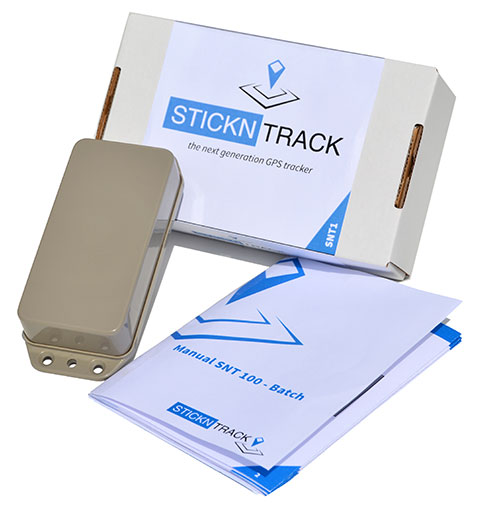
StickNTrack — an award-winning low-power tracker from Sensolus — is now active in eight European countries.
StickNTrack guards and tracks position, journeys, motion and status of any non-powered asset without the hassle of charging batteries, managing SIM cards or an intrusive installation, Sensolus said.
StickNTrack’s web-based service platform is tailored for low-power asset tracking communicating over the French-based Sigfox. Because Sigfox is an ultra low-power communication network, it significantly reduces StickNTrack’s power needs so that it consumes up to 40 times less power and lowers life-cycle costs by 50 percent compared to existing compact GPRS/GPS products, Sensolus said.
The tracker’s power can last up to five years. In the third quarter, an upgraded version will be released with extended battery lifetime up to nine years, according to Kristoff Van Rattinghe, who developed StickNTrack along with Laurence Claeys, Johan Criel and Koen Van Vlaenderen.
Users can access the StickNTrack web portal with any smartphone running Android OS or iOS. The full feature set can be accessed on a tablet or laptop. Features include interactive timelines, intuitive geofencing, email alerting and optimized energy savings.
The ruggedized, waterproof StickNTrack is 120 x 50 x 25 millimeters and weighs 255 grams. It can track assets on the water, such as yachts or buoys, providing automated logbooks, alerting users when assets enter or exit specific zones (such as harbors), and providing real-time journey information for those at home.
StickNTrack’s developers took third place in the 2014 European Satellite Navigation Competition, after taking first in the Flanders regional competition. It also won the European Space Agency’s Innovation Award.
Dubbed a “distruptive innovation” by the European Satellite Navigation Competition (ESNC), StickNTrack “opens up an abundance of new business opportunities in tracking trailers, containers, machinery, tools, bikes and more. Future accuracy and availability improvements based on GNSS will trigger additional advancements, such as by automating supply chains for packages and their delivery. Ultimately, stickNtrack is a next-generation location tracker that significantly lowers the barriers to embedding even more GNSS technology into our daily lives.”
“Every day new types of non-powered assets are being connected to our service platform,” Van Rattinghe said. In the coming years, Sigfox aims to provide global coverage.
TomTom has added navigable maps for 13 new countries. TomTom’s global map database now covers more than 45.6 million kilometers and 4.3 billion people worldwide, and features full navigable coverage for 134 countries.
“The addition of nearly 3 million kilometers of roads in one year demonstrates TomTom’s commitment to geo-expansion,” said Charles Cautley, managing director of TomTom Maps. “We rely on intelligent mapmaking and our transactional mapmaking engine to continuously deliver map updates around the globe, increasing coverage and improving map features for all business customers.”
Global map enhancements include:
The launch of navigable, turn-by-turn maps for Macedonia, Bosnia & Herzegovina, Peru, Guatemala, Nicarágua, Panamá, Costa Rica, Honduras, El Salvador, Iraq, Ghana, Rwanda and Burundi.
Introduction of Address Points to enable better geocoding and navigation in Austria, Luxemburg, Turkey and South Africa; significant growth in Address Point coverage for South East Asia reaching 3.6 million.
Significant Points of Interest growth in Mexico, bringing count to more than 3 million.
Launch of 3D Map for Singapore and the debut of visualization products for the Middle East, with an Advanced City Model of Riyadh and 2D City Maps for 15 cities.
The University of Michigan (U-M) has opened Mcity, a controlled environment designed to test the potential of connected and automated vehicle technologies that will lead the way to mass-market driverless cars.
Mcity is a 32-acre simulated urban and suburban environment that includes a network of roads with intersections, traffic signs and signals, streetlights, building facades, sidewalks and construction obstacles. It is designed to support rigorous, repeatable testing of new technologies before they are tried out on public streets and highways.
“There are many challenges ahead as automated vehicles are increasingly deployed on real roadways,” said Peter Sweatman, director of the U-M Mobility Transformation Center (MTC). “Mcity is a safe, controlled, and realistic environment where we are going to figure out how the incredible potential of connected and automated vehicles can be realized quickly, efficiently and safely.”
In particular, Mcity allows researchers to simulate the environments where connected and automated vehicles will be most challenged. Even seemingly minor details a vehicle might encounter in urban and suburban settings have been incorporated into Mcity, such as road signs defaced by graffiti and faded lane markings.
The types of technologies that will be tested at the facility include connected technologies — vehicles talking to other vehicles or to the infrastructure, commonly known as V2V or V2I — and various levels of automation all the way up to fully autonomous, or driverless vehicles.
Mcity was designed and developed by U-M’s interdisciplinary MTC, in partnership with the Michigan Department of Transportation (MDOT). It is a public-private partnership among industry, government and academia. The center was established to lay the foundation for a commercially viable ecosystem of connected and automated mobility that will revolutionize the movement of people and goods worldwide. A key MTC goal is to put a shared network of connected, automated (including driverless) vehicles on the road in Ann Arbor by 2021.
“We believe that this transformation to connected and automated mobility will be a game changer for safety, for efficiency, for energy, and for accessibility,” Sweatman said. “Our cities will be much better to live in, our suburbs will be much better to live in. These technologies truly open the door to 21st century mobility.”
The facility also underscores Michigan’s emergence as a leader in advanced mobility, building on the state’s position as the global center of automotive research and development for more than a century, U-M said in a news release. Today, Michigan is home to 375 automotive research centers, and has the highest concentration of industrial and mechanical engineers in the country.
MTC is a public-private partnership among industry, government and academia. The center was established to lay the foundation for a commercially viable ecosystem of connected and automated mobility that will revolutionize the movement of people and goods worldwide. A key MTC goal is to put a shared network of connected, automated (including driverless) vehicles on the road in Ann Arbor by 2021.
MTC’s industry and government partners reflect the diversity of perspectives required to meet the challenges ahead. In the private sector, MTC partners include automakers and top-tier auto suppliers, but also traffic signal and traffic sensing companies, insurance providers, telecommunications, big data, IT and more. On the public side, MTC is working with federal, state and city governments.
“Mcity represents an important partnership between government at all levels, private industry and academia,” said Kirk Steudle, director of the Michigan Department of Transportation. “State of Michigan officials are thrilled to be part of this vital collaborative, which will ensure that Michigan continues to be the world’s auto leader.”
In addition to Mcity, MTC has three on-roadway connected and automated vehicle deployments underway. With the help of the Michigan Economic Development Corporation, MTC is building on a nearly 3,000-vehicle connected technology project launched three years ago by the U-M Transportation Research Institute to create a major deployment of 9,000 connected vehicles operating across the greater Ann Arbor area. MTC is also partnering with industry and the Michigan Department of Transportation to put 20,000 connected vehicles on the road in Southeast Michigan. The third piece of the plan calls for deploying a 2,000-vehicle mobility service of connected and automated vehicles in Ann Arbor.
MTC was launched in 2013 and Mcity construction began last year. About $10 million has been invested in the test facility, with funding coming from U-M and MDOT. Mcity will be available for use by any organization, but priority will be given to MTC partners and U-M faculty and students.
MTC is working with 15 Leadership Circle member companies, each investing $1 million over three years, and engaging in thought leadership. Thirty-three Affiliate Members are also contributing, and investing $150,000 over three years. Current Leadership Circle companies are:
The value of accurate maps is not lost on the automotive industry as it transitions from connected cars to automated vehicles. Three German automakers are rumored to be making a multibillion-dollar investment in Nokia’s HERE mapping division. If the deal goes through as expected by late July, Nokia, which purchased HERE (then called Navteq) for $8 billion in 2007, will have spurned several deep-pocket suitors.
Although not officially confirmed, Nokia’s HERE digital mapping service is set to be purchased by a German auto consortium of Daimler, BMW and Volkswagen’s Audi unit, according to published sources.
Estimates of the deal place it in the $2.7 billion to more than $3 billion range. The potential sale puts to rest industry concern that Google or another giant non-automotive entity would make the winning bid for a company with increasing importance to connected and autonomous vehicles.
Either way, it’s too early to analyze what exactly are the consequences if the German consortium closes the deal with Nokia, said Thilo Koslowski, Gartner vice president and analyst. “In order to justify the purchase price of the acquisition, it will be in the interest of any acquiring party to keep Nokia HERE’s future role as neutral as possible in order not to alienate other clients,” he said. “I could imagine that contractually the acquiring party might be tied to serving these other clients for a least a certain time. If that doesn’t happen, and the deal would be ‘exclusive,’ then it would certainly boost the appeal of other map data providers and encourage new players to emerge.”
If the deal goes through, the German consortium plans to invite such other automotive companies as Fiat Chrysler, Ford, Renault, Toyota and General Motors, according to the Wall Street Journal.
Another take on the potential agreement could be whether car companies have to weigh the pluses and minuses of to join the consortium — or map competitor TomTom needs to consider whether it has more to gain from remaining independent or creating its own consortium, said Roger Lanctot, strategy analytics associate director, global automotive practice.
Industry old-timers may remember the bitter rivalry between Navteq (formerly Navigation Technologies) and Tele Atlas (formerly Etak). This rivalry has remained, even though the names have changed and the location industry has evolved dramatically since 2007, when both Navteq and Tele Atlas were bought by Nokia and TomTom, respectively, in multibillion-dollar deals.
The bidding war for HERE began in April, when Nokia purchased Alcatel Lucent to transition from the location industry. In addition to the German auto consortium, Uber and Chinese technology provider Baidu, Google and Apple were said to be potential buyers. However, Google’s purchase of HERE would have been disruptive to the auto industry, Lanctot wrote in a LinkedIn column. “Google buying HERE would drive the entire industry into the arms of TomTom while removing the leverage-ability of a map duopoly. Google buying both TomTom and HERE would annihilate billions of dollars in research and development activity by car makers seeking to create a truly driver-oriented browsing experience intended to enhance safety,” he wrote.
Mike Dobson, TeleMapics president, who writes about digital maps at www.telemapics.com, recently said that Uber was playing with fire by bidding on HERE because they were clearly concerned about autonomous vehicles. “Within 10 years, Uber will be producing its own fleet of [autonomous vehicles]. While owning a map company might be beneficial to them, they might be better off licensing map databases,” he said.
Uber, which bought mapping company deCarta and Microsoft’s Bing Maps, ultimately withdrew from the bidding war for Here.
City Built for Autonomous Testing Unveiled in Michigan
A 32-acre simulated city recently opened to test how self-diving cars will perform in the future. The $10 million facility, called Mcity and located on the north campus of the University of Michigan, was created by the school’s Mobility Transformation Center and the Transportation Research Institute.
With all the bells and whistles — a bridge, a tunnel, traffic circle, etc. — the facility will rival anything existing, if it hasn’t already surpassed it, in Silicon Valley or Pittsburgh, which seem to be the centers of gravity for the nascent autonomous vehicle industry.
Mcity, which was a government-industry partnership, plans to “lay the foundations for a commercially viable ecosystem of connected and automated mobility,” said a university press release. [Editor’s note: It is refreshing to see the “commercially viable” thrown in there by an academic institution.]
Another key goal is to implement a connected and automated mobility system on the streets of southeastern Michigan by 2021. The MTC is developing deployments of more than 20,000 cars, trucks and buses across southeastern Michigan, serving as testbeds for evaluating consumer behavior and exploring market opportunities, the university said.
At the same time as the Mcity announcement, also in Ann Arbor, the Automated Vehicle Symposium, which is the largest autonomous vehicle conference, was being held at a local hotel. While the conference had such keynote speakers as Google’s Chris Urmson, and sponsors that included Denso and Uber, it still has the feel of this government/academic/technical conference — not unlike TRB or ITS America.
In fact, like many government meetings, the afternoon “breakout sessions” were closed off to the press. This leads to the question, with so many new, and expensive, autonomous vehicle conferences springing up, why isn’t there a single panel on the future worldwide market opportunity?
In other location news:
IndoorAtlas signed a $3 million deal with South Korea’s SK Planet, a subsidiary of SK Telecom, to target the e-commerce market. IndoorAtlas’ investors include ST Planet and Chinese technology provider Baidu, which made a $10 million investment in the company.
Nokia’s HERE mapping and location services business is developing a new global standard for contactless transport ticketing payments using Near Field Communications-enabled mobile phones. HERE announced the formation of the Open Mobile Ticketing Alliance, or OMTA, to help consumers purchase public transit ticket using a mobile app.
HERE competitor TomTom continues to be a major force in vehicle monitoring and location, recently announcing its telematics division broke 500,000 subscribers. Overall, the company serve 36,000 customers, primarily in the European fleet market.
Not everyone wants to be located. Consumers think they have the ability to turn off the tracking ability of their phones. But can they? More about that later. In other news, there are good reasons why Nokia’s HERE mapping is still on the selling block. And blind people are using a no-tech version of a widely used location positioning method that doesn’t need canes.
The controls that phone makers have devised to enable consumers to opt out of being located have a big hole. Android-based phones are giving app makers free access to phone data that can be used to surreptitiously geolocate devices. The data comes from an unlikely source: power consumption, and no consent is needed.
The technique, called PowerSpy, was developed by researchers at Stanford and Rafael, Israel’s defense research group, and gathers a phone’s power usage history. Simplistically, the location of the phone is tracked by using the phone’s battery consumption to determine the distance of a phone to a cell tower. The further the distance, or the greater the obstacles blocking the tower, the more power is consumed by the battery. The researchers say they can take into account phone usage battery drain and filter out the noise created by focusing on long-term trends.
At its current level of development, the PowerSpy method requires the snoop to have driven a route (war driving) to identify its power consumption pattern. With tests conducted in San Francisco, the method worked with 90 percent accuracy to identify a correct route from seven choices. The team is working on using the data to detect unknown routes that have not been previewed.
How would the hypothetical stalker, crook or unethical mobile advertiser get access to this data? They would entice a person to download an app. The smoke screen app might be a game or a productivity app that is quietly slurping up the power consumption data.
Here Today, Not Gone Tomorrow? Wouldn’t you think that Nokia would by now have clinched a deal to sell the mapping division? Given its mapping debacle, Apple was on the top of everyone’s list as a buyer, but apparently the company didn’t even participate in the bidding, and instead is committed to further development of its self-built mapping database. Contenders — Facebook, Baidu, Tencent and Uber — seem to have dropped out of the competition. Left is a consortium of German automakers — BMW, Daimler and Volkswagen — who feel that they should get a better deal with no other buyers in sight. It is a double-edged sword, as they also worry that if the highly accurate maps are acquired by tech firms, the car makers will lose a competitive advantage in the fight for supremacy of the automated vehicle. High-precision mapping is critical to the success of the auto OEMs.
Who Will Win Connected Vehicles? Follow the Money. Investors who want a piece of the connected vehicle action are placing bets on the tech companies, not the auto OEMs. Many blue chip and small companies are seeing healthy gains in price. Sensor chip makers, car infotainment and telecom companies are some of the winners. With the surge of connectivity required in the Internet of Things, networking technology will also do well.
E911 Innovations. While regulations are in place for eventually requiring technology to automatically identify the location of indoor E911 calls, dispatchers don’t yet have that capability. Callers can be inside a large complex, like a dormitory or hotel, and if they are unable to speak or identify their location, response is hampered. Smart911 from Rave Mobile Safety is sending dispatchers floor plans of buildings to help in rescue efforts. The maps are automatically sent with the 911 call and have already been credited with quicker responses.
Quick Business News. Uber acquired Microsoft’s geo-imagery team and assets, known at BIT (Bing Imagery Technologies), which is based in Boulder. Microsoft didn’t need this technology as it had already outsourced Bing Maps technology to Nokia HERE. Telecommunication Systems (TCS) purchased location-based technology and intellectual property from Loctronix. The purchase will further TCS in developing indoor-location technologies. Denmark has become the first country to use real-time traffic data across a national network. Denmark will use GPS probe data managed by INRIX for congestion management. The Internet of Things relies on multitudes of sensors and a new start-up, Sense360, has built a platform to manage that data.
No-Tech Location Technology. Daniel Kish was a particularly helpful kid who made deliveries for his mom to homes outside of his neighborhood. What is unusual is that Kish is blind and uses echolocation to “see” the space around him. He clicks his tongue to ascertain the unique echoes of his surroundings, starting by identifying areas of high or low density, such as tall buildings, squat houses or open space. And in a version of drive testing, blind users like Kish first walk a neighborhood with a sighted guide and remember the signature echoes. Whether it is solely by ear or with a big computer algorithm like PowerSpy, pattern mapping can be effective.
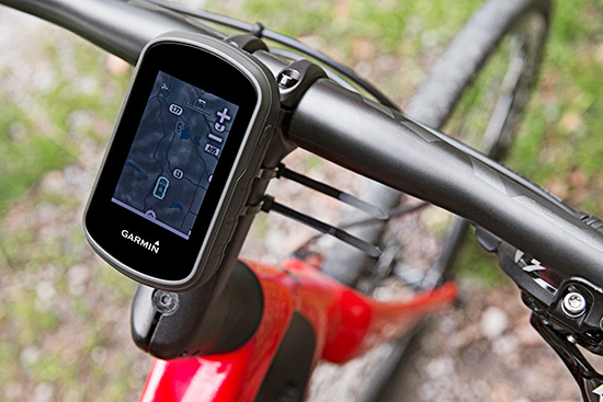
The Garmin eTrex can be mounted on bicycles, boats, ATVs or in the car.
Garmin International this summer is releasing the eTrex Touch 25, 35 and 35t, adding new touchscreen models to its line of outdoor handhelds.
The eTrex Touch series has a completely updated user interface, improving the ease-of-use of the device, as well as a 2.6-inch capacitive touchscreen display, the largest display that’s ever been put on an eTrex device. The eTrex Touch series also features new activity profiles for easy-to-use navigation for multiple activities and an enhanced track manager to easily start and stop recording.
The new eTrex Touch series has a high-sensitivity, WAAS-enabled GPS receiver with GLONASS support and HotFix satellite prediction to locate users’ position quickly and precisely, even in heavy cover and deep canyons.All units in the eTrex Touch series have a built-in 3-axis tilt-compensated electronic compass, which gives directional information even when standing still. The eTrex 35 and 35t also have a barometric altimeter to get more accurate altitude, elevation and climb information, as well as indications of pending weather changes.
The eTrex Touch 25, 35 and 35t are compatible with an array of mounts that are easy to use on bicycles, boats, ATVs or in the car, and offer a long-lasting 16-hour battery life, and a rugged ergonomic design to withstand the elements.
The eTrex Touch series integrates a variety of new activity profiles. The device remembers how each profile is set up to each activity, and will set it up for users the same way every time, making it comfortable, quick and intuitive to use the same device for entirely different purposes. No matter if users are out rock climbing, hiking, hunting, cycling, geocaching or fishing, with an eTrex Touch, switching between activities is easier than ever, even if they’re done all in one afternoon.
The eTrex Touch series comes preloaded with a worldwide shaded relief basemap, 4 GB of internal memory on the 25 and 35 models and 8 GB of internal memory on the 35t. The eTrex 35t also comes preloaded with TOPO U.S. 100K. With the built-in microSD card slot, users can install even more maps, like HuntView to see public and private land data while hunting, BirdsEye Satellite Imagery or TOPO U.S. 24K. All models come preloaded with 250,000 geocaches from Geocaching.com, so right out of the box users can start their geocaching adventure virtually anywhere in the world.
The eTrex 35 and 35t incorporate wireless ANT+ connectivity to accessory sensors like heart rate monitors, the Tempe temperature sensor, Chirp geocaching beacon, or the cycling speed sensors and cadence sensors. The eTrex 35 and 35t can also act as a wireless remote control for the VIRB line of action cameras. The eTrex 35 and 35t can connect via Bluetooth to compatible smartphones to receive smart notifications and stay connected out on the trail, but keep their phone safely packed away from the elements. Additionally, these units are compatible with the the Garmin Connect mobile app, for features such as LiveTrack. With LiveTrack, users can pair their device with the app, and invite friends and family to follow their activity in real time. This provides peace of mind, especially if users are alone.
The eTrex Touch 25 will have a suggested retail price of $249.99, the eTrex Touch 35 will have a suggested retail price of $299.99 and the eTrex Touch 35t will have a suggested retail price of $349.99.
Microsoft will no longer collect its own map data, according to the website re/code. As part of the change, Microsoft is selling some of its assets to rideshare company Uber, including a data center, cameras, intellectual property and roughly 100 engineers. Uber is also buying a data center near Boulder, Colo.
Microsoft plans to continue to offer Bing Maps using data licensed from partners.
Microsoft already gets much of its map data from Nokia and other partners, but had been collecting its own aerial, 3D and street-level maps. It will now source those images from partners, focusing its Bing Maps work on the user experience that overlays the map data and imagery.
Industry watchers suggest the cameras might soon end up on the roofs of Uber vehicles. Uber already has hundreds of thousands of cars being tracked around the world every day.
TeleCommunication Systems (TCS) has purchased location-based technology and intellectual property from Loctronix. TCS is integrating the newly acquired assets from Loctronix with its location solution portfolio. Combined, the location-based services (LBS) solutions will enable TCS to further develop indoor-location technology applications ranging from advertising and marketing to navigation and public safety, TCS said.
TCS specializes in secure and reliable wireless communications. The company’s patented solutions enable 9-1-1, commercial location-based services and deployable wireless infrastructure; cybersecurity; defense and aerospace components; and applications for mobile location-based services and messaging.
“Purchasing LBS technology and intellectual property from Loctronix not only adds to our already vast set of intellectual property rights for LBS, more importantly it underpins our continued commitment to further building out our advanced location product portfolio,” said Jay Whitehurst, TCS senior vice president and Commercial Software Group president. “In addition to expanding the breadth of our current location product offering, the Loctronix assets will provide clear differentiators in device location, and increase our market and revenue opportunities — both for commercial and public safety applications.”
“We have exciting news,” Loctronix announced on its website. “The global leader in Precise Device location, TeleCommunication Systems, Inc. (TCS) has integrated our assets with theirs. We have always said that our mission was to locate any device anywhere — indoors or outdoors. With our technology, TCS will now be able to do just that.”
TCS plans to roll out new solutions leveraging the Loctronix assets by year’s end.
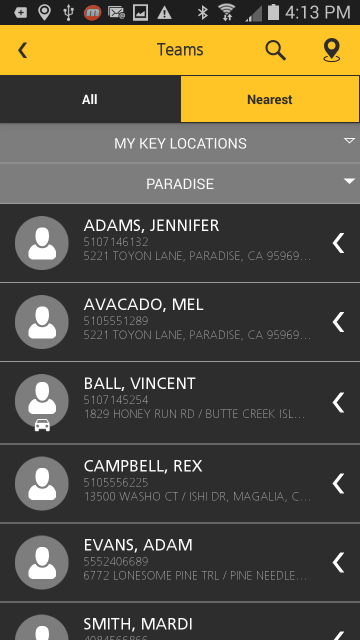
Trimble has announced the addition of a Supervisor app to its FieldMaster suite of mobile applications. The latest addition to the suite is designed to enable managers to stay efficient and effective on the go by empowering them to do more work in the field and manage their day-to-day operations remotely. With the FieldMaster Supervisor app, managers can leave the office and still have visibility into their fleet and mobile workers from their smartphone or tablet.
“Mobility is an increasingly valuable tool for field service organizations,” said John Cameron, general manager of Trimble’s Field Service Management (FSM) Division. “It allows a traditional office role to move into the field and still access up-to-date information about the performance of the field operation. The result is a more effective operation where managers in the field have the information they need at their fingertips.”
“I’m often meeting with customers or surveying a job so it’s important for me to know my technicians’ location,” said Dave Rowan, manager of Del-Mar Doors in Delaware. “I use FieldMaster Supervisor whenever I’m on the road. I can open the app and see where my team is, where they’ve been and how long they’ve been at each location. Having quick access to this information has improved my efficiency and productivity. FieldMaster Supervisor is an excellent tool.”
FieldMaster Supervisor is available with Trimble Fleet Management and Trimble Work Management solutions. Features include:
Viewing all locations of your entire team on a map
Seeing each team member’s job progress, including tasks at riskF
Finding the nearest worker to another team member or customer
Navigating to key locations using turn-by-turn directions
Inspecting job performance and documenting status in the field
Receiving important vehicle and driver performance alerts in real-time
FieldMaster mobile applications are a core component of FSM’s integrated suite of field service management solutions that includes Fleet Management, Work Management and Driver Safety. FieldMaster also includes a Technician app, which is an advanced collaboration tool for mobile technicians that allow them to receive, access and update job information in real-time for improved effectiveness on the job.
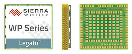
Sierra Wireless has introduced its next generation of the AirPrime WP Series of smart wireless modules for the development of connected products and applications for the Internet of Things. The WP Series provides an integrated device-to-cloud architecture enabling IoT developers to build a Linux-based product using a single module that sends valuable user and product data to the cloud.
AirPrime WP is part of Sierra’s new AirPrime smart portfolio, which includes:
AirPrime WP Series offering an application processor, GNSS receiver, and cellular modem with an optional ultra-low power mode that reduces power consumption by 200 times, opening up new use-case possibilities for cellular connectivity.
Legato Linux-based platform integrated directly into the application processor of the WP modules providing an open-source application framework and professionally maintained Linux distribution.
Project mangOH open hardware reference design for the WP modules offering wireless, sensor, and cloud connectivity out-of-the-box to rapidly build prototypes.
AirVantage cloud and connectivity services providing device, application, and connectivity management as well as an IoT data platform securely integrated into the WP.
“With the introduction of the new AirPrime WP Series modules, we have launched a powerfully integrated device-to-cloud architecture to make it easier for our customers to innovate,” said Dan Schieler, senior vice president, Embedded Solutions for Sierra Wireless. “With an application processor running the open source Legato platform, along with the AirVantage cloud for device and application management, and a new open hardware reference design, the latest WP Series modules enable developers to quickly build connected products using a single module to run all their applications.”
The WP Series is interchangeable and completely footprint-compatible with the AirPrime HL Series, and is available in 3G and 4G LTE variants with 2G fallback on certain modules. Like the HL Series, the new WP Series modules can be soldered down or used with a socket, for flexibility in manufacturing and inventory management. The form factor, called CF3 (common flexible form factor), will be supported by Sierra Wireless through multiple generations of both WP and HL Series product lines, providing a secure migration path for customers through multi-year deployments.
The next-generation AirPrime WP Series offers industry-leading ultra-low power mode for applications that need to prioritize power management over constant connectivity. This deep-sleep mode is designed for industrial solar- or battery-powered applications where constant connectivity is not required, opening up new use-cases for cellular connectivity where it was previously impractical.
For OEMs and developers, the integration of processors and device software with wireless functionality can be complex and time-consuming, even more so when modifications are required for each region and each generation of the product. If location-based services are required, a GNSS receiver must be integrated as well. Furthermore, the data from the wireless connection, the connected asset, and its location must be aggregated and delivered to enterprise applications.
The next-generation AirPrime WP Series is designed to address all of these issues. It offers an integrated processor and a GNSS receiver, reducing the number of components, integration time, and cost for developers. The Linux-based Legato platform running on the module’s processor provides the modem services needed to get the module communicating on a cellular network, plus an application framework and secured processing space to run third-party applications. Through Legato, AirPrime WP modules are pre-integrated with the AirVantage cloud for simple, secure configuration and management of the device and its data once deployed.