Apple has acquired Coherent Navigation, according to various media reports.
Coherent Navigation is a Bay Area GPS firm founded in 2008 by engineers from Stanford and Cornell. One of its areas of focus was high-integrity GPS (iGPS), an enhanced version of GPS that uses both normal, high-altitude GPS satellites and lower-altitude voice and data satellites from Iridium to increase the accuracy of a consumer’s GPS reading from the ground.
The acquisition seems to be Apple’s latest efforts to bolster its mapping capabilities.
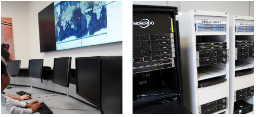
McMurdo has opened an Emergency Readiness and Response Experience Center at its Washington, D.C., location. The center will showcase the latest innovations and technology developments for search and rescue (SAR) in an immersive experience with real-time demonstrations of the entire SAR process — from distress beacon activation to satellite-based location detection to emergency response coordination.
The facility will feature a working MEOSAR (Medium Earth Orbit Search and Rescue) satellite-based search and rescue system, the next-generation version of the current Cospas-Sarsat satellite system that has saved more than 37,000 lives since 1982. When fully deployed in the next 3 to 5 years, MEOSAR will greatly improve the existing SAR process with global coverage, near instantaneous distress beacon detection and a unique Return Link Service feature that acknowledges distress signal receipt. MEOSAR’s advanced technologies will be able to accurately detect and locate a distress beacon signal almost instantaneously instead of taking up to 30 minutes today.
Visitors to the center will gain an understanding of the different search and rescue technologies by taking part in various search and rescue scenarios. Participants will also have the opportunity to sit at the controls of mission control center and rescue coordination center systems, similar to the McMurdo solutions used around the world by NASA, National Oceanic and Atmospheric Administration (NOAA), Australia Maritime Safety Authority (AMSA), Maritime New Zealand (MNZ) and other SAR authorities.
“This cutting-edge Experience Center allows us to demonstrate the incredible advancements being made in search and rescue all in a single location,” said Jean-Yves Courtois, CEO of McMurdo. “Our decades of experience in pioneering the latest SAR advancements, our leadership position as the only company that provides an end-to-end SAR ecosystem and our ongoing commitment to saving lives put us in the unique position to showcase these emergency readiness and response solutions for our customers, our partners and the industry.”
Guests will also see SAR-enhanced applications such as fleet management, coastal surveillance and innovative partner solutions for aviation, fishing, maritime, military and other industries. Classroom training and other educational sessions led by industry experts and SAR specialists will take place at the new center.
“The McMurdo Experience Center is unique in its ability to make the entire search and rescue process come to life, which we haven’t seen done before in a centralized setting,” said Bruce Reid, CEO, International Maritime Rescue Federation (IMRF). “We at the IMRF are delighted to be working with McMurdo on a variety of SAR training, education and awareness activities. Access to this location as a true center of excellence for the search and rescue sector can only enhance this activity.”
Personalized, custom tours of the McMurdo Experience Center for customers, partners and press can be reserved.
McMurdo products and services are used by some of the biggest names in the world including Airbus, Boeing, British Airways, Embraer, Southwest and United Airlines as well as the British Royal Navy, U.S. Coast Guard and numerous global search and rescue authorities. McMurdo was instrumental in the high-profile rescue of Clipper Round the World Race Sailor Andrew Taylor and was recently named as the official safety beacon partner of the hit reality series Deadliest Catch.
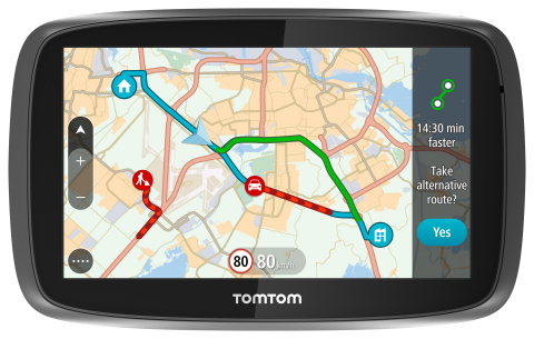
TomTom is introducing Lifetime World Maps and Lifetime Speed Cameras to drivers with the launch of four new TomTom navigation devices.
TomTom is introducing Lifetime World Maps and Lifetime Speed Cameras to drivers with the launch of new TomTom navigation devices. Lifetime World Maps allow people to drive with maps from around the world at no extra cost, for the lifetime of their TomTom GO device2. Lifetime Speed Cameras let drivers know the locations of all speed cameras — both fixed and mobile, also for the lifetime of the device.
The TomTom GO 510, 610, 5100 and 6100 feature a fully interactive screen to pinch, zoom and swipe — as well as a rich user interface, simplified user interaction, 3D Maps and a Click & Go mount. Drivers can also choose between a 5-inch or a 6-inch screen size, TomTom said. The new TomTom GO devices also include “Drive Home” and “Drive to Work” buttons in the main menu, for faster, simpler navigation.
TomTom GO devices combine real-time traffic information with routing technology, to always offer drivers the fastest route available. TomTom Traffic covers all mapped roads and combines data from millions of data sources, from all over the world, to deliver traffic information so accurate that, with each new update, it can pinpoint the start and end of a traffic jam, precisely, down to 10 meters.
“With the addition of Lifetime World Maps and Lifetime Speed Cameras to our new TomTom GO devices, we’re offering the most comprehensive package to drivers that we’ve ever launched,” said Corinne Vigreux, co-founder and managing director, TomTom Consumer. “Our aim is to help you avoid the jams, getting to your destination faster, wherever in the world you might be.”
Lifetime TomTom Traffic is available via a smartphone connection on the TomTom GO 510 and 610. The TomTom GO 5100 and 6100 offer Lifetime TomTom Traffic via a built-in SIM with unlimited data and roaming at no extra cost.
The new TomTom navigation devices are compatible with TomTom MyDrive4. For the first time, drivers can use their smartphone, tablet or PC to review real-time traffic information, plan routes, and send destinations to their TomTom GO, before they get in the car. Previously launched TomTom GO devices5 are also compatible with MyDrive though a simple software update. Find out more about TomTom MyDrive here.
The new TomTom GO devices are now available online and in-store from €199.95.
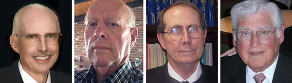
From left: Dennis McCarthy, Wayne Hanson, Ronald Beard and William Klepczynski
By Dennis McCarthy, Wayne Hanson, Ronald Beard and William Klepczynski
Once again we are going to adjust the world’s clocks by one second. This time it will happen on June 30, when we insert another leap second in Coordinated Universal Time (UTC), the standard international time scale. In theory, all UTC clocks should insert a second labeled 23h 59m 60s (the leap second) following one labeled 23h 59m 59s UTC. This is equivalent to having all of the clocks in the world stop for one second at that time.
Are you ready for it?
The last leap second occurred two years ago on June 30, 2012, and the continuation of the process of making these one-second adjustments has stirred a growing controversy over the last few years.
How did the leap second come about — and why do we continue making these sporadic adjustments?
From Sun to Caesium
Historically, it has been easy to make use of the apparently uniform repetition of various astronomical phenomena to measure the passage of time. We’re familiar with the Sun rising and setting, and this regularity provides us a convenient measure of time: the solar day. In recent times until 1960, the average solar day was used as the basis for timekeeping, and if we divide the day into 24 hours, each containing 60 minutes made up of 60 seconds, we can define the second as 1/86,400 of the mean solar day. This meant that the length of the second depended on the Earth’s rate of rotation because it is the rotating Earth that causes the Sun to appear to move across the sky.
In the mid-1930s, astronomers concluded that the Earth did not rotate uniformly as measured by the most precise clocks then available. This causes the duration of a second to vary as the Earth’s rotation rate varies. We now know that a variety of physical phenomena affect the Earth’s rotational speed, and consequently this definition of a second became impractical for applications that require a truly uniform time scale. So, in 1960, the second was redefined in terms of the Earth’s yearly orbital motion around the Sun. The time scale provided by this astronomical phenomenon was called Ephemeris Time (ET), to call attention to the fact that its realization depended on the conventionally adopted positions and motions (that is, the ephemeris) of the Sun (or Moon) that was used in the analyses of the required astronomical observations. The second defined in this manner was called the Ephemeris second.
Although Ephemeris Time does provide a more uniform measure of the duration of a second, it is inconvenient to make the necessary astronomical observations that would be required to maintain a practical time scale for applications that demand high precision. So, in 1967, the second was redefined again, this time in terms of the frequency of an energy level transition in the Caesium atom, which had already been calibrated with respect to Ephemeris Time by using astronomical observations of the Moon’s motion. Caesium frequency standards, by the early ’60s, had become known as reliable, uniform, accurate and precise clocks. The second defined in this way provided, and continues to provide, a uniform standard of time that can easily be measured in a laboratory with greater precision and accuracy than any astronomical phenomena.
Lab Clocks Rule
Although the second defined using the frequency of an atomic energy level transition does provide a unit of time duration that is precise and uniform, it does mean that the passage of time measured in this way is no longer connected to astronomical phenomena. Indeed, with the advent of more accurate observational techniques, astronomers could measure variations in the Earth’s rotation rate by measuring its changing orientation in space and comparing the rate of change with laboratory clocks. They established that among the various variations in the Earth’s rotation rate is the gradual slowing down with respect to a uniform atomic time scale. This deceleration is consistent with theoretical tidal effects and observed terrestrial deglaciation.It is also apparently consistent with ancient observations of solar eclipses, indicating that that this slowing has been going on for thousands of years
As a result, if we were to observe a recurring astronomical event, we would see it happening earlier from day to day. To bring our clock back into agreement with the astronomical event, we would have to add some time to the face of our atomic clock. While astronomers can cope with this situation by applying the appropriate corrections derived from astronomical observations that measure the Earth’s rotation rate, navigators that relied on astronomical observations to determine their positions considered this situation problematic.
When the definition of the second based on the Caesium atom was introduced, it was known that there would be a time varying discrepancy between a clock running at a uniform rate and a theoretical one using a second defined by the Earth’s rotation rate. Starting from 1961, the observed discrepancy was modeled by making small adjustments on the order of a few milliseconds (thousandths of a second) to our clocks at first, and later by making small adjustments to the frequency of the atomic clocks from time to time, usually on an annual basis. This meant that the duration of a second could vary depending on when it was measured.
No More Changes
In 1970 the International Radio Consultative Committee (CCIR and now known as the International Telecommunications Union Radiocommunications Sector, or ITU-R) in collaboration with other international agencies adopted a definition of UTC that did away with any periodic changes to the duration of the second. Instead it was decided that the discrepancy between UTC and the observed rotation angle of the Earth would be accounted for by making one-second adjustments when needed, so that the absolute difference between UTC and the Earth’s rotation angle measured in time units would always be less than 0.9 seconds. A finer correction would also be provided frequently so that the Earth’s rotation angle in time units designed as Universal Time 1 (UT1) could be derived to 0.1 second precision.
It was specified that the one-second adjustments, either positive or negative, were to be made preferably at 23h 59m 59s on the last day of the months of December or June, but could also be made, if necessary, at 23h 59m 59s on the last day of the months of March and September, and further if required at 23h 59m 59s on the last day of any month. The implementation of this definition actually began in 1972, a year in which two leap seconds were introduced.
These one-second adjustments came to be known as “leap” seconds by analogy with the “leap” day inserted in calendars. This definition then fixed the second in UTC to be uniformly established as the international standard atomic second defined by the resonance frequency of Caesium and known as the SI (Système International) second.
Compromise Overcome by GNSS
The introduction of the concept of the leap second was historically a compromise with practitioners of celestial navigation who needed to base their observations on astronomical time to determine their longitude. If UTC doesn’t differ from the observed rotation angle of the Earth by more than a second, navigators could use UTC directly as a substitute without introducing a systematic error greater than a quarter of a mile. However, the routine practice of using celestial navigation has been overcome by the success of Global Navigation Satellite Systems (GNSS), inertial navigation systems, and radar navigation.
In fact, the U.S. Naval Academy stopped including celestial navigation in its curriculum in 1998. In the time span since the introduction of the idea of a leap second, computer networks, wireless telecommunication systems, satellite communications, telephone networks, air traffic control systems and even industrial processes have developed to the point where precise time is an essential component of their successful operation. Users and suppliers of these systems are concerned with the impact of sporadic, essentially unpredictable, one-second adjustments.
Most of these modern systems derive their time using GPS timing receivers. Although the navigational solutions make use of GPS System Time, these receivers provide UTC by means of a broadcast correction that provides the time-varying difference between GPS System Time and UTC. This correction normally provides the varying difference between the two times to less than a microsecond but must also keep track of when a leap second is introduced. As the leap second changes occur sporadically, there may be worries that problems could arise because hardware or software may never have been tested thoroughly for a leap second occurrence. As a result of these concerns, as well as the cost of stopping all of the clocks in the world for one second, the ITU-R has been discussing a possible revision of the definition of UTC by dropping the future use of leap seconds.
Leap or Not Leap?
The question of the future of UTC was raised in 2000 with the suggestion of modifying it to be a continuous timescale without leap seconds. Consideration of this question is still ongoing. The 2012 World Radiocommunication Conference (WRC-12) identified this issue as urgent, requiring further examination by the 2015 World Radiocommunication Conference (WRC-15) “to consider the feasibility of achieving a continuous reference time-scale, whether by the modification of Coordinated Universal Time (UTC) or some other method, and take appropriate action…”.
With the aim of providing adequate technical background for WRC-15 to make an informed decision on this issue, the International Bureau of Weights and Measures (BIPM) and the ITU agreed to organize jointly a workshop on the future of the international time scale. This workshop was held in Geneva, Switzerland, in September 2013. It provided a unique opportunity to present available information on current and possible future precise frequency and time standards, sources and their characteristics, time scales and dissemination systems and different views on the future of UTC.
Contributions to the workshop were specifically invited to ensure that the breadth of the issue would be covered. Included were the relevant international organizations (the International Astronomical Union, the International Earth Rotation and Reference Systems Service, the International Union of Geodesy and Geophysics, the International Organization for Standardization, the International Maritime Organization, the International Civil Aviation Organization, the Union Radio-scientifique Internationale), the providers of GNSS services (GPS, GLONASS, Galileo and BeiDou), the national metrology institutes that realize and maintain local representations of UTC, the ITU member administrations, and the ITU-T and authorities responsible for electronic time services. Information on the workshop, agenda and presentations is available.
Final Decision in November
A special issue of ITU News magazine dedicated to the workshop has also been published; an online version is available. It did not provide a decision on the issues, but rather a forum for issues to be discussed, since there is some controversy over modifying the global reference time scale. The final decision is to be made at the WRC-15 in November when the method for satisfying the feasibility of achieving a continuous time scale will be determined as well as how it would be implemented.
As preparations begin for the June leap second, hardware and software will undergo testing. This process is likely to be repeated for some time to come, even if the decision to eliminate the use of leap seconds in UTC is made. Legacy systems reliant on the use of leap seconds will require an adequate period of time to adapt to any change in the definition of UTC. If the suppression of leap seconds would be decided, it is recommended that a period of time no less than five years be allowed before the Final Acts of the WRC-15 go into effect. So, leap seconds could be with us for some time yet.
Editor’s Note: For an earlier discussion on the leap second by McCarthy and Klepczynski, download the Innovation article “GPS and Leap Seconds: Time to Change?” from the November 1999 issue of GPS World.
Dennis McCarthy is retired, and serves as a contractor with the U. S. Naval Observatory, where he was science advisor, director of the Directorate of Time, and head of the Earth Orientation Department. Internationally, he has served as president of the Commissions on Time, Commission on Earth Orientation, and Division 1 (Fundamental Astronomy) of the International Astronomical Union (IAU). He was also secretary of Commission 5 of the International Association of Geodesy.
Wayne Hanson has been a consultant and president of Time Signal Engineering since his retirement in 2001 as chief of the Time and Frequency Services Group in the Time and Frequency Division of the National Institute of Standards and Technology. He is the U.S. chairman of the International Telecommunication Union – Radiocommunication Sector, Working Party 7A concerned with Time Signal and Frequency Standard Emissions.
Ron Beard is the head of the Advanced Space PNT Branch at the Naval Research Laboratory and International Chairman of ITU-R Working Party 7A, Precise Time and Frequency Broadcast Services. During the early development of GPS in the 1970s, he was the project scientist in the NRL GPS Program Office that developed Navigation Technology Satellites One and Two that operated the first atomic clocks in space.
William Klepczynski is now retired. During his career, he was a consultant to the Institute for Defense Analyses and the head of the Time Service Department of the U.S. Naval Observatory, where he managed the USNO Master Clock, timing operations for GPS and time distribution systems that utilize communications and navigation systems.
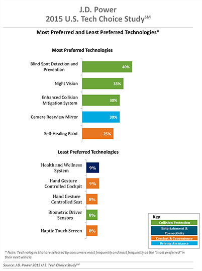
Three of the top five technologies consumers most prefer in their next vehicle are related to collision protection, according to a new J.D. Power 2015 U.S. Tech Choice Study.
Technologies that reduce the overall burden of driving and enhance the safety of the vehicle and its occupants receive the most consumer attention. Among the technologies consumers express most interest in having in their next vehicle are blind spot detection and prevention systems, night vision, and enhanced collision mitigation systems. These findings demonstrate growing customer acceptance towards the concept of the vehicle taking over critical functions such as braking and steering, which are the foundational building blocks leading to the possibility of fully-autonomous driving. The only non-collision protection technologies to crack the top five are camera rearview mirror, which falls into the driving assistance category, and self-healing paint, a comfort and convenience category.
In contrast, technologies in the navigation category have low preference across all vehicle price segments.
The inaugural study uses advanced statistical methodologies to measure preference for and perceived value of future and emerging technologies. A total of 59 advanced vehicle features are examined across six major categories: entertainment and connectivity; comfort and convenience; collision protection; driving assistance; navigation; and energy efficiency.
“There is a tremendous interest in collision protection technologies across all generations, which creates opportunities across the market,” said Kristin Kolodge, executive director of driver interaction and HMI research at J.D. Power. “In contrast, there is very little interest in energy efficiency technologies such as active shutter grille vents and solar glass roofs. Owners aren’t as enthusiastic about having these technologies in their next vehicle because of other efforts automakers are taking to improve fuel economy, as well as relatively low fuel prices at the present time.”
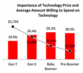
Gen Y Willing to Spend Most for Technology
Across all generations, price is the most important consideration for technology, accounting for 25.2 percent of importance. Gen Y is the least sensitive to technology price and shows a greater willingness to spend on new technologies than the other generations. Gen Y consumers, who have accounted for 27.7 percent of new-vehicle sales thus far in 2015 — second only to Boomers at 37.1 percent — are willing to spend an average of $3,703 on technology for their next vehicle. Gen X is willing to spend $3,007, while Boomers, who show the greatest price sensitivity, and Pre-Boomers are willing to spend only $2,416 and $2,067, respectively.
Importance of Technology
A certainty in the automotive domain is the impact the consumer electronics world has had upon it. From shifting consumer expectations of user interaction, to the rapid pace of technology introduction and importance of keeping software up to date, to the miniaturization and creation of cost-effective solutions for sensors and cameras, “the auto industry is standing on its head to keep technology up to consumers’ new standards,” said Kolodge. “Those who haven’t done so have seen negative feedback from consumers.”
Apple CarPlay vs. Google Android Auto
Smartphones play an increasingly vital role in everyday life, and vehicle technology is beginning to mirror what is offered on those devices, yet Apple CarPlay and Google Android Auto technologies consistently have among the lowest preference scores across all generations.
Consumer preferences for Apple CarPlay and Android Auto are uniquely dependent on which smartphone they own. Those who currently own a smartphone that is compatible with one of these technologies would choose the technology compatible with their phone at only a moderate rate, while those with the opposite brand of smartphone will rarely, if ever, choose that technology. For example, Android owners indicate that Apple CarPlay is “unacceptable” nearly twice as often as they indicate that solar glass roof is unacceptable.
Similarly, Apple phone owners indicate that Android Auto is “unacceptable” nearly twice as often as solar glass roof.
Kolodge noted that “lukewarm interest in these technologies that connect your phone to your vehicle coupled with consumer loyalty to their phone poses a unique challenge for automakers, which could be remedied by knowing their customers’ phone preferences.”
“Owners of luxury vehicles tend to own iOS devices, 1 so for many luxury brands, offering Apple CarPlay may be the best option, realizing they may be leaving out a portion of the market,” said Kolodge. “For nonluxury vehicle brands, the ownership of Apple and Android devices is much closer to an equal split. The solution for those brands may be to offer both operating systems and allow customers to select the option best suited for them.”
Key Findings
Full self-driving automation technology, part of the collision protection category, is designed to perform all safety-critical driving functions and monitor roadway conditions. The younger generations (Gen Y and Gen X) have substantially higher preference for the technology than the older generations (Boomer and Pre-Boomer). The Pre-Boomer generation, in contrast, has a greater preference for lower levels of automation, such as traffic jam assist.
Blind spot detection and prevention has high preference across the range of vehicle price segments. In contrast, reverse auto braking systems have low preference across the vehicle price segments and preference wanes as vehicle prices increase.
Advanced sensor technologies, such as hand gesture controlled seats, biometric driver sensors or haptic touch screens have low preference.
Technologies in the navigation category have low preference across all vehicle price segments.
The 2015 U.S. Tech Choice Study was fielded in January through March 2015 and is based on an online survey of more than 5,300 consumers who purchased/leased a new vehicle in the past five years.
TomTom is partnering with Mozilla and Telefónica to bring its Maps Online and Nav Online apps to HTML5-powered Firefox OS smartphone devices.
“We’re thrilled to offer Firefox OS users TomTom’s Maps Online and Nav Online apps in the Firefox Marketplace,” said Bertrand Neveux, director of Marketplace and Ecosystem at Mozilla. “Our priority is to empower users with a mobile experience that makes their lives richer and more efficient, and great content like TomTom’s ensures that.”
“Telefónica has now launched Firefox OS devices in 14 markets and is pleased to see high-quality maps and navigation solutions from TomTom that enhance these devices for our consumers in Latin America and Europe,” said Simon Callan, director Business Development at Telefónica.
“TomTom is excited to be embracing the openness of HTML5 to bring high quality maps and turn-by-turn navigation to the ecosystem,” said Charles Cautley, managing director of TomTom Licensing. “By partnering with Mozilla and Telefónica, we’re opening new markets and opportunities for smartphone users globally.”
TomTom Maps Online offers accurate and up-to-date maps, as well as Address and Point of Interest search capabilities with routing instructions, enabling Mozilla customers to quickly and easily find their favorite places, TomTom said.
With TomTom Nav Online, Telefónica’s Firefox OS customers can extend the mapping experience to full voice-guided turn-by-turn navigation.
It has been an interesting month for developments in location. Nokia is looking for a buyer for HERE, the mapping and navigation business that once set the industry gold standard. While carriers are planning how they will comply with new FCC mandates for locating indoor E911 calls, the commercial indoor location market has moved beyond “emerging” and is well underway. It is a confusing ecosystem for buyers of indoor location solutions. And there is yet another mega-entry into the connected vehicle market, Alibaba and China’s SAIC Motor.
With the likely merger of Nokia and Alcatel-Lucent, Nokia has started looking for a buyer for its digital map and LBS division. The mapping industry has changed dramatically since Nokia purchased the mapping leader Navteq in 2007. Google has become a mapping juggernaut, and less accurate free maps have become serviceable for many types of uses. In fall 2014, Nokia took a EUR1.2-billion impairment charge on HERE’s book value and now estimates the fair value for HERE at EUR2 billion. Possible buyers include Google, Microsoft, Apple and Uber, all companies with deep pockets and hardy appetites.
Indoor Location Market Is Messy. The indoor location market is pulling away from the station, as technology is ready and there are applications and use cases primed to get started. Unfortunately, the market is chaotic, teaming with companies offering solutions with various levels of accuracy, infrastructure requirements and cost. An ideal indoor location technology would provide at least 3-meter accuracy, be cost effective and fully universal, working anywhere on all devices. It doesn’t exist, but the competing technologies, all with trade-offs, will find applications that fit. For instance, the precision required in locating an apartment in the case of an E911 emergency call differs greatly from the pinpoint accuracy need by an app that directs a shopper to Lucky Charms cereal on an aisle crowded with boxes.
One Size Doesn’t Fit All. There is more to an indoor location technology than accuracy. “Accuracy is important, but so is universality, the ability to work everywhere and in all phones. So is cost, in terms of the investment required from a site deploying the technology,” asserts Bruce Krulwich of Grizzly Analytics. “Universal technologies can win in the market even if they’re less accurate, and technologies with cheaper infrastructure can win even if they’re less accurate than those with expensive infrastructure. High-end systems can deliver sub-meter accuracy to those willing to pay for it.” Grizzly Analytics just completed a comprehensive report on the indoor location market.
Test First. Each of the numerous companies vying for the indoor location market makes claims regarding accuracy, availability/coverage, latency and battery usage. Judicious companies that invest in indoor location systems would be wise to test the claims of vendors. “Making a fair comparison among different indoor location offerings is complex, and nuances in how the testing is performed need to be controlled to ensure an apple-to-apple comparison,” asserted Khaled Dessouky of ComVerity. “It is important to use an unbiased methodology that relates to your use cases.” Dessouky managed the neutral test bed for the FCC’s Communications Security, Reliability and Interoperability Council (CSRIC) for indoor E911 calls.
Quuppa. An interesting highly accurate offering comes from Quuppa, a Finnish company with a bunch of high caliber researchers spun off from Nokia. Like some others, they are using Bluetooth Low Energy (BLE) beacons, but add angle of arrival (AOA) algorithms that pump up the precision, which they self-report to be 30 centimeters to 1 meter. With this performance, Quuppa has been used in sports to track hockey pucks and athletes’ movements during game play for coaching, player load monitoring and infotainment that can be broadcast during the game. The use of this type of high-precision location in health care settings is compelling. Patient flow management, security and critical asset tracking can be improved with precise positioning technology. Quuppa is a system that likely wouldn’t be used in apps that locate a coffee shop at a mall, but for uses that demand high performance and can spare some expense, it is compelling.
And Yet Another Mega Entry. The number of companies vying for a piece of the connected-car market keeps expanding and getting more international. E-commerce giant Alibaba and SAIC Motor, China’s popular car maker, together set up a $160 million fund to develop “car on the Internet.” Alibaba will be leveraging its communications, entertainment, map and cloud-computing services. The company joins a group that includes Google, Apple, Baidu and Uber in challenging auto makers.
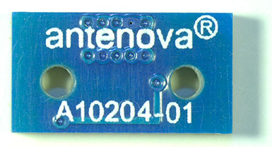
The Brevis GNSS antenna is the latest addition to Antenova’s gigaNOVA family of miniature antennas. The small antenna is designed to be used in portable handheld devices that have GNSS receivers — for example, in devices and applications that have a tracking capability or location accessories such as in transport, navigation, wearables and eHealth.
The multi-GNSS antenna is designed for embedded applications, with a high efficiency-to-size ratio. It is intended for use in applications where there is no ground beneath the antenna. It has near omni-directional characteristics which will provide good performance for any device.
The Brevis operates with the following GNSS bands: GPS, GLONASS, Galileo and BeiDou. Brevis GNSS is a low-profile, small-footprint antenna designed for surface-mount device (SMD) mounting, so it can simply be placed on a printed circuit board (PCB) to add wireless connections to any device.
Full technical specifications for the Brevis GNSS antenna and contact details for regional distributors are available on Antenova’s website.
The National Association of Broadcasters meeting in Las Vegas draws 100,000 attendees annually, making it one of the largest trade shows in the country. However, besides timing and some very niche markets, it has not been a big show for location companies. That is, until now, when NAB welcomed drone manufacturers, all of which embed GPS in their flying aircraft.
Kevin Dennehy
LAS VEGAS — Commercial drones, a growing market for location companies, was one of the most popular topics at the National Association of Broadcasters Show, held here April 13-16.
The market for drones has grown nearly five times in the last few years, said Eric Cheng of DJI, which uses GPS in its virtual positioning system that monitors and controls the aircraft. The company markets what they call “flying cameras” that look suspiciously like drones. “The market was initially hobbyists, but now some major broadcast players are buying the cameras,” Cheng said at the Showstoppers trade event the day before NAB.
Most of the drones offer GPS-based automatic flight stabilization technology. Some even offer a long-range wireless signal and low-latency video transmission.
Many of the drones are programmed so they don’t go higher than mandated FAA rules or go into restricted, no-fly aviation zones — and all use GPS to do this. Some of the drones even return to the user automatically when their batteries run low.
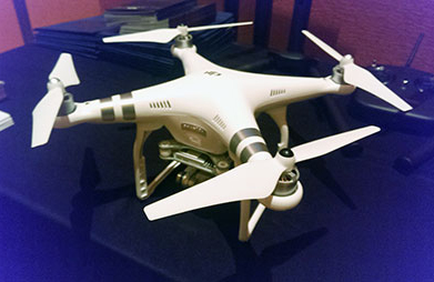
DJI drone with embedded GPS.
DJI offers three cameras for the drones. The high-end Phantom 3 Advanced offers 1080P HD video at 60 frames per second. The 1080P version costs $995.
In terms of privacy and government regulation, U.S. regulators are way behind Europe, Cheng said. “Other countries are way ahead of the [United States] in terms of working with drone companies,” he said. “In terms of privacy, the step ladder was the first tool for the invasion of privacy. They haven’t outlawed step ladders.”
The slow U.S. regulatory process has forced some manufacturers to go to other countries to test their drones, said Roger Sollenberger, 3D Robotics’ editorial director. “[U.S. regulations] have moved slowly here — despite the government knowing about worldwide drone rollouts. In Japan, they have been using drones to crop dust for 20 years,” he said.
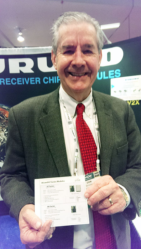
Furuno’s Don Hanham with GNSS modules at NAB.
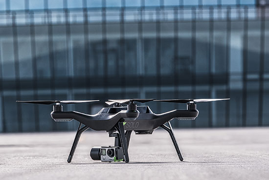
To signal increased interest in the commercial drone market, 3D Robotics raised $70 million dollars in funding, led by investor Qualcomm, Sollenberger said. The company, which partnered with action camera giant Go Pro, says its Solo drones can be used not only by broadcast companies, but for railroad track and building inspections.
As GPS World reported, Furuno Electric Co.’s latest multi-GNSS receiver module, GN-87, has been adopted for the new quadcopter Bebop Drone. The broadcast market has been a good one for company’s timing products, drone integration and even weather prediction, said Don Hanham, a Furuno sales and marketing consultant.
Furuno is marketing its Doppler Weather Radar System for broadcast. The system allows weather predictors to follow the development of short, localized rainstorms and extreme weather conditions.
Booz Allen Hamilton Releases Report on 2015 Automaker Priorities
The era of automotive connectivity, and subsequent heavy competition, is the focus of Booz Allen Hamilton’s new report, “Getting the Customer Experience Right: Auto Industry Priorities in 2015.”
The company says that automakers should consider six key priorities this year: deliver innovation in months, not model years; differentiate with new partnerships to catch customers’ attention; secure connectivity to reinforce a relationship of trust with customers; address the “so what” of connected cars; personalize the customer experience via the tremendous potential buried in data; and find and build the market for alternative fuel vehicles.
In terms of big connected vehicle technologies this year, Jon Allen, a principal with Booz, cites 4G pipe in GM and Audi vehicles and over-the-air updates by Ford and BMW, among others. “New parental controls in the Chevy Malibu report average speed and near misses while also preventing drivers from turning on the stereo until seatbelts are fastened. It’s easy to imagine this across vehicles, with parents receiving text messages in real time,” he said.
Allen said, in terms of vehicle connectivity, automakers must answer the “so what” to set themselves apart from the competition. “We have yet to see the seminal, game-changing connectivity plays. Most companies are still in the ‘features’ mindset, offering new à la carte enhancements,” he said. “They’re not yet articulating a top-down strategy for re-envisioning the customer experience with connectivity.”
One of the company’s six priorities concerns connected security, which has been a big industry issue since the recent release of the Markey Report, which focused on how vehicles can be hacked. “We have clients who get it. They’ve identified a senior leader to champion vehicle cyber security and backed them up with a cross-functional team that works closely with counterparts across the organization — in product engineering, supply chain, safety, privacy and IT,” Allen said. “Other OEMs are still formulating their approach. That said, there are pockets of cyber security across every organization, focused on implementing security controls on individual parts. The challenge is taking the next step —moving from this segmented, ‘assembly line approach’ to a more unified program that focuses on securing the complete vehicle ecosystem.”
Allen said the company has to speak honestly to customers and regulators about how to manage vehicle cyber security risk. “Industry leaders must prioritize their security approach to ensure that higher risk scenarios are addressed first, rather than try to take on all elements of the challenge at once,” he said.
Another priority addresses the long lead times, by automakers, to develop and roll out new features, which is a challenge, Allen said. “Consumer electronics, telecommunications and software companies are redefining the traditional industry boundaries that once distinguished them from OEMs. These companies focus on connectivity and services from the start of their product design process,” he said. “The key for automakers going forward is to continue learning from these new competitors, particularly around rethinking the vehicle lifecycle, connected product design, and managing vehicle software updates after purchase. In the near future, automakers will need different approaches to building and enhancing infotainment systems that can keep pace with customer demands.”
The marriage of autonomy and connectivity is a game-changer, Allen said. “It isn’t just about plugging vehicles in to the Internet of Things. Autonomy transforms transportation,” he said. “When a car drives you, it becomes a retail outlet, a personal assistant, even a trusted chaperone — that all depends on getting both autonomy and connectivity right.”
The rise of autonomous vehicles gets to the fundamental need for industry leaders to be willing to reimagine their product, Allen said. “Autonomous capabilities are not just about engineering a safer, more efficient, and more appealing mode of transportation. That’s important, but it’s really about a distinctly different product, one that creates a sustained, services-based relationship with the customer,” he said. “It will focus on the driving experience not just behind the wheel, but sitting comfortably inside of a self-driving vehicle. The connected, autonomous vehicle will change automotive for the better — and forever.”
Allen said his company is seeing OEMs look beyond their individual vehicles to see the emerging connected society that includes ride sharing, multi-modal transportation and connected cities. “The way we go from point A to point B will look and feel drastically different 25 years from now; many OEMs are beginning to accept the change and embrace the challenge,” he said.
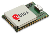
u-blox is offering the CAM-M8C — a small, low-profile GNSS positioning module with an integrated wideband chip antenna for reception across the entire L1 band. The module offers simultaneous GNSS operation for GPS/GLONASS, GPS/BeiDou, or GLONASS/BeiDou to deliver accurate, jamming-resistant and reliable positioning anywhere in the world.
The CAM-M8C integrates a u-blox M8 satellite receiver, crystal oscillator, SAW filter and low-noise amplifier. It also has an input for an external active antenna — when using this option, the internal antenna acts as a backup. Because of its design, the module maintains its performance regardless of physical orientation, making the product suitable for mobile applications with frequent change of bearing.
“Where space is at a premium, for example in emergency call systems, in handheld navigation or in wearable devices, the CAM-M8C module offers a very cost-effective way to bring products to market quickly due to its small size and high levels of integration,” said Kim Kaisti, product manager, Product Center Positioning. “It does this without compromising performance or reliability, and leaves system designers free to concentrate on other important aspects of their product development.”
The CAM-M8C is footprint-compatible with u-blox UC530 and UC530M modules, providing an easy upgrade path, the company said. The module is available now.
To further accelerate design and development, an evaluation kit, EVK-M8CCAM, provides a way to become familiar with the CAM-M8C module and assess its performance in specific applications.
The u-blox M8 GNSS receiver antenna module is delivered in u-blox Professional Grade, and is qualified to JEDS47 and ISO16750 standard “Road vehicles – Environmental conditions and testing for electrical and electronic equipment.” The product is manufactured in ISO/TS 16949 automotive-certified production sites, ensuring the high quality and reliability
Ford Motor Company and Telogis have expanded their exclusive partnership to bring Ford Telematics powered by Telogis to Ford’s commercial customers in the United Kingdom first, with other European markets to follow later this summer. Ford Telematics uses real-time information from Ford vehicles to enable businesses with workers in the field to have insight into vehicle location, driver behavior and fuel consumption.
The telematics can save companies up to 20 percent on fuel, according to a 2012 Frost & Sullivan report.
Since 2011, Telogis has been the exclusive technology provider to power Ford Telematics (formerly Ford Crew Chief) in the U.S. and Canada, with comprehensive and scalable telematics for commercial customers. The UK expansion of the Telogis-Ford partnership leverages the success of Ford Telematics in the U.S. and Canada and will meet the demand from current and new Ford customers in the UK for in the visibility into day-to-day operations including Ford vehicle diagnostics.
“Ford Telematics is an innovative system that can deliver reductions in cost of ownership for businesses that operate Ford’s Transit commercial vehicles,” said Paul McDermott, manager, CV aftersales, Ford of Britain. “Real-time vehicle location and diagnostic data provides fleet customers with a powerful tool to manage their vehicles more effectively and also encourage safer driving.”
Making its debut at the 2015 Commercial Vehicle Show, Ford Telematics will be available to fleet customers in May as a dealer-installed option, offered through Ford’s network of specialist Transit Centres.
Ford Telematics functions by securely transmitting vehicle data and metrics from the vehicle to a dedicated Telogis website via an embedded cellular connection. The telematics system’s ability to access proprietary Ford vehicle data enables operators to track details such as oil change warnings, water contamination in diesel fuel, tire pressure, safety belt usage and airbag status.
“The reality of being able to visualize field staff and the performance of each Ford vehicle — all on one screen — is here,” said Paul Reynolds, automotive director at Telogis. “This visibility enables Ford commercial customers to provide better service for their own customers and run their businesses more productively and efficiently — it’s no longer a ‘nice to have’ but a ‘have to have’ solution.”
Based on the real-time data, the Ford Telematics powered by Telogis software platform delivers a comprehensive range of actionable business information that enables fleet managers to operate their vehicles in the most efficient way and to help ensure drivers are following safe and economical driving practices.
Advances include a suite of more than 80 pre-loaded reports, integration with established business operating systems and fuel card services. Ford Telematics and the Telogis platform also allow for a BYOD (Bring Your Own Device) approach, helping to further reduce hardware costs and increase productivity.
Ford Telematics is compatible with Ford’s latest range of Transit commercial vehicles — including the all-new Transit, Transit Custom, Transit Connect and Transit Courier — as well as the Ford Ranger pickup. Additionally, the same Telogis hardware can be fitted to any other vehicles on the fleet, regardless of manufacturer, allowing informed fleet managers to view the whole fleet in one place, with all the usual driver performance and vehicle tracking information that they expect.
Ford Telematics also provides a gateway to the broader cloud-based Telogis platform that includes a suite of connected vehicle technologies including route optimisation and planning, commercial-grade navigation, work order management and mobile applications to drive additional efficiencies and productivity for mobile enterprises.
“Ford Telematics is another example of Ford facilitating the delivery of smart technology to help our customers enjoy the highest quality, safest and most sustainable operation of commercial vehicles available today,” said Nick Themistocleous, director, Fleet Operations, Ford of Britain.
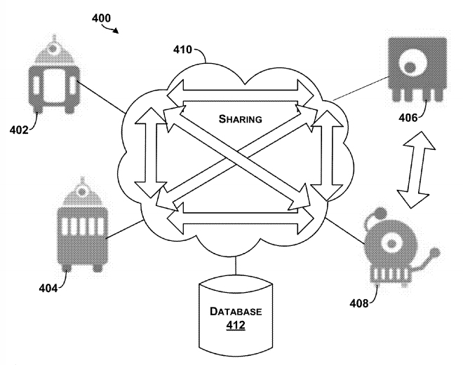
The Google patent shows an example system in which robotic devices interact with the cloud and share information with other cloud computing devices.
In a patent awarded April 14, Google describes “systems and methods for allocating tasks to a plurality of robotic devices,” reports Nextgov.com.
Google’s patent (Patent #9,008,839)outlines methods for connecting a series of robots over the cloud to complete tasks. A robotic device configured to perform a task could make use of a GPS receiver to determine its location. It might also use other sensors, such as a gyroscope or an accelerometer to measure movement. Other sensors could be encoders, infrared sensors, optical sensors, biosensors, Radio Frequency identification (RFID) systems, wireless sensors and compasses.
The patent suggests that the robots could be controlled by a smartphone — from anywhere in the world.
The patent could have value for Google’s self-driving car project, allowing the vehicles to communicate with each other.
In another patent (Patent #US008996429), awarded on March 31, Google describes how a robot’s personality can be defined using sensors and the cloud. According to the patent, “methods and systems for robot and user interaction are provided to generate a personality for the robot.” One aspect includes basing the robot’s personality on identifying the user’s location.
The personality and state may be shared with other robots so as to clone this robot within another device or devices. In this manner, a user may travel to another city, and download within a robot in that city (another “skin”) the personality and state matching the user’s “home location” robot. The robot personality thereby becomes transportable or transferable.
Again, GPS is mentioned as a possible sensor for use either in the user’s smartphone, the robot, or both.
So, in the future, when you leave home, you may be able to take an interactive non-human friend along. Talk about location-based services!