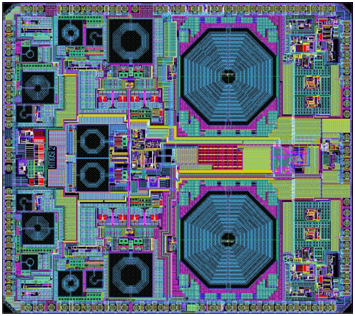
NTLab, a fabless microelectronic company based in Belarus, is offering the NT1051 dual-channel multi-frequency (L1/L2/L3/L5) mutli-system (GPS/GLONASS/Galileo/BeiDou) RF front end.
Manufactured in 0.18 um TSMC BiCMOS technology, it provides operability of the GNSS receiver even if interference power is 120-dB higher than the satellite signal.
The chip was designed to bring benefits of high-grade GNSS receivers to portable devices. To allow reliable navigation in the presence of interference, NT1051 has a 1-dB compression point (on RF input) of -40 dBm. This allows stable tracking, even if the interfering signal is 120-dB higher (compared to -160 dB of typical tracking sensitivity) than the satellite signal.
Simultaneously, portable devices require reduced power consumption. There is always a tradeoff between receiver linearity and consumed current, so the task of combining high dynamic range with low consumption was successfully solved in NT1051 architecture, NTLab said. The resulting power consumption is below 60 mW.
To allow dual-antenna receiver configurations, NT1051 has two separate channels with a common fractional frequency synthesizer.
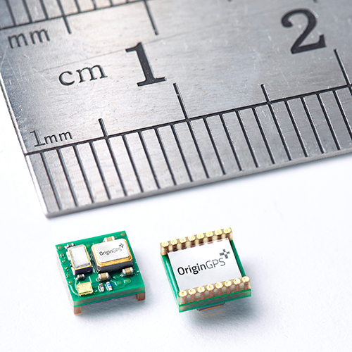
OriginGPS has launched the Nano Spider, a tiny yet fully integrated GPS receiver. The Nano Spider module is designed to support ultra-compact applications where size is at a premium, such as smart watches, wearable devices, trackers and digital cameras.
OriginGPS, which previously introduced the Micro Spider (5.6 x 5.6 mm) module, said the Nano Spider is 47 percent smaller than its previous solutions, measuring 4 x 4 x 2.1 mm. The Nano Spider’s proprietary structure is a multi-level circuit for surface mounting, built to reduce footprint size.
“The wearable technology trend requires components that balance a small size with high-performance and best-in-class power consumption,” said Gal Jacobi, CEO of OriginGPS. “OriginGPS aims to continue to shrink the size of components, while increasing features to make adding location functionality possible for every device.”
OriginGPS’ Nano Spider continuously tracks all GPS satellites in view and provides real-time positioning data in the standard industry format defined by the U.S. National Marine Electronics Association (NMEA). The Nano Spider offers a complete System in Package (SiP) that includes:
Fully integrated features – The Nano Spider includes a low noise amplifier (LNA), surface acoustic wave (SAW) filter, temperature controlled crystal oscillator (TCXO) and real-time clock (RTC) crystal, a power management unit, and radio frequency (RF) shielding.
Superior sensitivity and performance – The Nano Spider module offers accuracy of approximately one meter, and achieves a rapid time to first fix of less than one second and tracking sensitivity of -163 dBm.
Continuous connectivity with minimal power consumption – It achieves a state of near continuous availability by detecting changes in context, temperature and satellite signals by maintaining and opportunistically updating its internal fine time, frequency, and satellite data, while consuming microwatts of battery power.
Improving marginal signal conditions – It includes OriginGPS’ proprietary Noise Free Zone (NFZ) system to increase noise immunity even under marginal signal conditions, such as urban canyons, under dense foliage or a rapidly changing receiver position.
To see a demo of the Nano Spider and Nano Hornet modules, visit OriginGPS’ booth (Hall A4 Booth 271) at Electronica 2014 in Munich, Germany.
The new NEO-M8L Automotive Dead Reckoning (ADR) module by u-blox has integrated motion, direction and elevation sensors. The module integrates gyro and accelerometer with u‑blox’ GNSS platform u-blox M8 to achieve high indoor/outdoor positioning performance for road vehicle and high-accuracy navigation applications.
In addition to accessing the integrated module’s gyro and accelerometer data, accident reconstruction systems can provide the location of an accident to facilitate insurance claims even if a collision occurs in a tunnel or park house. High-end navigation devices are able to guide drivers through tunnels of several kilometers because of the accuracy of u-blox’ ADR system. Stolen vehicles can be located instantly due to continuous monitoring of sensor data and storage of location in non-volatile memory.
“Devices for usage-based insurance, stolen vehicle recovery, road pricing, fleet management, emergency services, and vehicle navigation depend on reliable, uninterrupted positioning including tunnels, park houses and stacked highways,” said Thomas Nigg, vice president of product strategy at u-blox. “The NEO-M8L is the ideal solution for all road vehicle based applications, able to calculate a position in all circumstances based on its own internal sensors, regardless of satellite visibility and end-device orientation.”
The NEO-M8L module will be demonstrated at the u-blox stand at electronica 2014 in Munich, November 11-14, Hall A4 Stand 219.
The compact module is 12.2 x 16.0 x 2.5 mm, requires minimum host integration resulting in no risk, is low cost, and provides fast time-to-market design, u-blox said. With uncritical orientation of the installed module, odometer function and autonomous data logging, it is an all-in-one solution for all road vehicle applications requiring reliable and uninterrupted position in challenging environments such as urban canyons, tunnels and underground parking.
The NEO-M8L embeds u-blox’ 3D Automotive Dead Reckoning (3D ADR) chip technology. Using the vehicle’s speed information and the module’s onboard sensors enables accurate positioning in three dimensions, even when satellite signals are completely lost and the end-device installation is not horizontal, u-blox said. An odometer function, based on the ADR technology, also provides accurate and continuous distance traveled.
The module is able to track all visible GNSS satellites including GPS, GLONASS, BeiDou, QZSS and all SBAS (European’s Galileo will be supported in a future firmware version). Concurrent reception of two GNSS systems is supported. The NEO-M8L module can output a position up to 20 times per second.
The module uses u‑blox’ M8 GNSS chip and is available in Professional Product grade. This grade includes qualification according to the ISO16750 standard “Road vehicles — Environmental conditions and testing for electrical and electronic equipment” and manufacturing in ISO/TS 16949 automotive-certified factories.
Samples and evaluation kits will be available in December 2014.
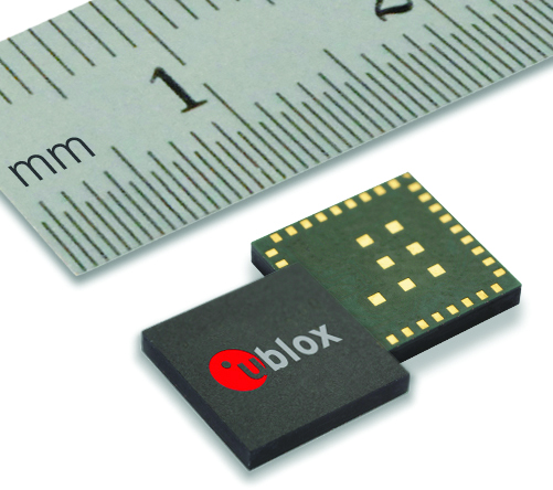
Swiss-based u‑blox has introduced the EVA‑M8M stand-alone positioning module. The EVA-M8M GNSS module brings concurrent multi-GNSS performance into the ultra-compact EVA footprint.
Designed for cost- and space-sensitive applications, the highly integrated 7 x 7 x 1.1 mm LGA module comprises all necessary components, including crystal and passives. EVA-M8M only requires an external antenna to provide an accurate position without the need for host integration. Components have been selected for reliable operation in the field over the full operating temperature range. The module is also compatible with the EVA-7M GPS module, allowing for easy upgrading of existing designs at minimal cost, u-blox said.
The module supports GPS, GLONASS, BeiDou, QZSS, and SBAS augmentation systems. Based on u‑blox M8 performance, the module achieves -164 dBm tracking sensitivity, fast acquisition time and low power consumption. EVA-M8M can track any two GNSS systems simultaneously and output a GNSS position up to 18 Hz.
“The EVA-M8M sets a new industry benchmark for compact, stand-alone global positioning performance. The module has been designed for the absolute lowest eBOM costs and ease-of-manufacturing. It is a perfect solution for cost-sensitive industrial and wearable devices,” said Thomas Nigg, vice president of product strategy at u-blox.
A UART, USB, SPI and I2C interface provide flexible connections to a host processor. EVA-M8M can also communicate directly with u‑blox’ SARA 2G, LISA 3G and TOBY 4G cellular modules to support advanced tracking and location-aware products.
Detailed information about the EVA-M8M can be found on the u-blox website. Samples are available now. For existing designs using a NEO module, the C88-M8M adaptor board can be used for easy evaluation of the EVA-M8M in existing NEO-xM designs.
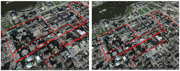
A single-feed smart antenna (left) compared to the multipath rejection results of the new TW5340 smart antenna with Accutenna technology. Photo: Tallysman
Tallysman’s new TW5340 smart antenna is designed to pair Tallysman‘s Accutenna technology antenna with STMicroelectronics’ Teseo II receiver. The combination makes the smart antenna accurate for use in all environments, including urban canyons, according to the company.
The TW5340 is a multi-constellation GNSS Smart Antenna that provides simultaneous GPS/GLONASS/SBAS reception. It is designed for use in professional-grade applications such as precision timing, network synchronization, low current applications, and tracking/positioning applications.
To illustrate the advantages of this technology coupling, simultaneous recordings of vehicle position were conducted using two smart antennas — one with and one without Tallysman’s Accutenna technology — in an area of downtown Ottawa, Canada, notorious for high levels of multipath signals. Results show how the high multipath signal rejection capabilities of Tallysman’s Accutenna technology greatly improves accuracy, the company said.
The Tallysman TW5340 smart antenna.
The TW5340 supports STMicroelectronics Autonomous A-GPS, which accelerates GPS positioning by predicting satellite ephemeris data based on previous observations. This results in extremely fast time-to-first-fix. The TW5340 can be configured to output up to three NMEA 0183 message lists with navigation update rates up to 10 Hz. RS232, CMOS, and USB interfaces are available with input voltage options of 3,3V, 5.0V, and 12V. A standby-mode feature provides for very low current consumption (<100uA) and is particularly useful in battery-operated applications.
A standard one pulse-per-second 1PPS synchronized to UTC time is available as a single ended output or as a differential output at RS422 levels.
Tallysman’s Windows-based Configurator enables simple configuration of parameters such a baud rates, output message rates, constellation, tracking parameters, 1 PPS configuration and standby-mode parameters.
The TW5340 is housed in an IP67 housing and is REACH and ROHS compliant. A non-magnetic version is also available as Part Number TW5341.
NovAtel, Inc.’s Calgary facility has been awarded the prestigious 2014 Manufacturing Excellence Award from the Association for Manufacturing Excellence (AME). The award acknowledges North American facilities that have demonstrated excellence in manufacturing and business, and recognizes NovAtel’s dedication to continuous improvement, best practices, creativity and innovation.
A representative of the AME presented the award to NovAtel at the company’s Calgary headquarters on October 23. NovAtel will also be recognized at the 2014 AME International Excellence Inside Conference, November 10-14 in Jacksonville, Florida.
NovAtel Inc. designs and manufactures high-precision, OEM, global positioning products and employs more than 400 people.
During their evaluation, the AME assessment team highlighted NovAtel’s work culture, observing that improvement systems were evident throughout the organization. They also praised the company’s commitment to creating a continuous improvement culture and systems. The assessment team remarked, “NovAtel leadership and plant employees can be proud of the site’s manufacturing excellence achievements to date.”
“We are very proud to receive an award which recognizes NovAtel as a leader in Enterprise Excellence in North America,” said Michael Ritter, president and CEO of NovAtel. “Fostering a culture of innovation, excellence and continuous improvement, in all aspects of our business, is something we strive for every day.”
Ritter added, “Our lean manufacturing initiatives are just one of the many ways we strive to add value for our customers. Making data-driven decisions in combination with fostering employee teamwork, mutual respect and accountability, throughout all levels of our organization, is essential to our long-term success in a global marketplace.”
“This award confirms that we are indeed on the right path 11 years into our ‘Lean’ journey,” said Mike McAloney, VP Operations for NovAtel. “We view ‘Lean and Continuous Improvement’ initiatives as the foundations of the operational excellence that lets us achieve our corporate mission: to generate customer success by providing precise positioning and augmentation technologies that are easy to integrate and provide exceptional return on investment.”
KCS BV has launched a new tiny tracker, the TM-202LAR. It’s the newest addition to the KCS family of TraceME products. The KCS GPRS/GPS range of modules enable users to remotely track and trace people, animals and a variety of objects, such as vehicles, containers, motorcycles, lawn mowers, or other valuable assets.
KCS TraceME TM-202LAR is targeted for personal use, or any other application that needs a small size with long battery life while still featuring the options and server connection that full-size units have.
The TraceME TM-202LAR is KCS’s smallest full featured GPS tracker at 46 x 21 x 6.5 mm, weighing 7 grams. Other features and options include:
GPS, RF and GSM antennas
advanced power saving, down to 2.5µA
10 years of operation from one Lithium C-Cell
RF connectivity, up to 2 km
location-based positioning (LBS/Wi-fi/GPS)
onboard sensors for compass, temperature, acceleration
Because of nonstop government regulation, which can help and hinder the trucking industry, the mobile resource management market will continue to be one of the strongest location segments. In other news this month, while it doesn’t get much bigger a deal in the location industry than a $2.5 billion purchase, as in the case of Qualcomm buying CSR, one smaller deal that should not be overlooked is ST Telecom’s acquisition of Shopkick, a growing indoor location provider.
SAN DIEGO — The global trucking market for fleet management products has always been strong — and one of the first location segments to have prospered over the last 15 years. This market growth will continue because of new technology and government requirements, say attendees at the American Trucking Association annual management conference here.
An American Transport Research Institute report offered at ATA, “Critical Issues in the Trucking Industry – 2014,” outlines 10 issues, mainly driven by government regulation, that concern fleet owners.
One of the big issues is hours of service (HOS). Rules adopted by the feds require 11 hours of driving — and a 34-hour break before restart. This includes a 30-minute break before driving again after eight hours. ATRI believes these rules cost carriers $1.6 billion to $3.9 billion annually in driver pay impacts.
An electronic device (ELD) mandate requires all drivers to keep records of duty status via a logging device. A mandate could come in 2016 that outlines hardware specs.
Another big issue is truck parking — and could be an opportunity for mapping and location companies. Because HOS regulations require drivers to take many breaks, shortage of parking is a big and dangerous concern because drivers are operating beyond allowable rules to find areas to park. ATRI wants closed public rest areas to reopen. They want real-time truck parking information availability and trucking parking reservation systems.
Driver distraction in the form of texting and driving is a growing concern. ATRI wants the feds to ban hand-held cell-phone use/texting for all motorists, encourage harsher penalties and more aggressive enforcement, and to continue to research to understand the size of the distracted-driving problem.
Other issues include driver shortage, health and retention; compliance, safety, Accountability (CSA); and congestion funding.
“My takeaway from [ATA’s] luncheon panel was that the trucking sector is in pretty good shape overall, except for the driver shortage. In regard to mobile resource management (MRM), I would estimate overall growth in in-cab and trailer monitoring at less than 10 percent per year,” said Clem Driscoll, president, CJ Driscoll Associates. “The Truckload sector is heavily penetrated with in-cab solutions. Most large carriers have a system. CSA is motivating some sales to mid-size fleets, but many small fleets are waiting for the ELD regulations. So, the delays with ELD regulations have probably been slowing market growth.”
Such companies as AT&T are trying to address the growing trucking requirements with new and existing products. For example, Saia LTL Freight, a trucking and logistics company, is managing its fleet of trucks with several AT&T products. Saia drivers are using handheld computers to connect with dispatch managers and monitor fuel consumption, safety, and location using AT&T’s wireless network.
“[SAIA] is a trucking company that is using all our capabilities. We partnered with them from an early stage, starting with the [Electronic Device Mandate] requirements,” said John Moscatelli, AT&T advance resource management solutions director. “Then we helped them with rugged handhelds and voice where necessary.”
Overall, Moscatelli sees a few fleet trends emerging. “There have been a lot of mergers and acquisitions in this industry. I also see that trucking companies are very aware of forced hours of service regulations for every company [mandated by the government],” he said. “It will not necessarily be the first adopter of technology that will be needing units. We have looked at the demographics, and even small and medium fleets are going to need affordable connected systems. The other trend is the growth of government sales — local, state and federal — very strong.”
Targeting a large worldwide market, Trimble has acquired several companies in the fleet space in recent years. One of them is Minneapolis-based PeopleNet, which is gearing up for the ELD mandate with an “Internet of Transportation Things” strategy that includes multiple devices talking to each other, said Randy Boyles, company senior vice president, tailored solutions.
The company rolled out its Wi-Fi-enabled in-cab scanning feature at ATA that allows drivers to scan and transmit transportation documents.
PeopleNet, along with ALK, GEOTrac, Vusion and TMW Sysems, are part of Trimble’s Transportation and Logistics division. Trimble has allowed their purchased companies to operate autonomously.
“About 95 percent of our management team is still intact. TMW still works with Omnitracs and others, but you will see a convergence with [other Trimble companies],” said Boyles, who believes that oil and gas pipeline monitoring/mapping is a growing niche.
The fleet and enterprise market is a growing space for Magellan, said Mark Perini, company associate vice president. The company has been offering its Magellan RoadMate 9496T-LMB Android unit for the fleet market.
“The unit enables bulk updates using our smart GPS technology. The Android operating system has been a growing technology for fleets,” Perini said. “The HOS regulations require reporting of how many hours truckers are off duty. With our management system, operators can implement a full set of protocols [to achieve HOS compliance]. It’s on a server, so the driver can’t change anything.”
Telogis Partners with Ford
Telogis has grown from a small company to a major player in the fleet market. The company recently announced it will be the “technology provider” for the Ford Crew Chief in North America, which is an expansion of its European partnership with the automaker.
In Europe, Ford’s telematics products will be offered to customers as a dealer-installed option and will feature vehicle location, diagnostics and performance.
The company has also been a major player in the U.S. market, integrating into Volvo Link, said Kevin Moore, Telogis vice president of OEM sales at ATA.
“While the trucking business is huge, the aftermarket is also growing,” he said. “While location information is central to what we do, we are constantly growing the platform. We are looking to be the only product that provides crowdsourcing for the commercial market.”
Even though the U.S. fleet market is growing, other world markets are growing by double digits each year. Driscoll, in his China Commercial Telematics Market Study, says the Chinese markets are growing at 20 percent, or more, each year. “China is manufacturing over 600,000 commercial trucks per year for internal use, so the addressable market is growing at a very fast rate,” he said. “China has a very inefficient logistics system and spends far more on logistics than the U.S. or Europe as a percentage of GDP. The government is very aware of the problem and is mandating the use of satellite tracking solutions in a number of sectors. Systems being sold in China today typically support both GPS and BeiDou (Compass).”
In other ATA news:
Orbcomm rolled out its GT 1100 chassis tracking solution to allow trucking companies to monitor where their rigs are located. It also allows operators to see if a trailer is mounted.
10-4 Systems is offering real-time data products NonStop, NonStop Mobile and NonStop premium. The company has a track/trace asset management capability for operators.
Qualcomm to Buy CSR for $2.5 Billion
The recent announcement by Qualcomm saying it would buy United Kingdom-based CSR for $2.5 billion signals continued inroads into the connected car and Internet of Things markets for the San Diego company.
In 2009, CSR, which stands for Cambridge Silicon Radio, purchased SiRF Technology, a GPS pioneer that was making huge strides in indoor location technologies. CSR, mainly known for its wireless Bluetooth technology, has chips in such products as audio speakers and Apple-owned Beats headphones.
The connected car market will be a big one for Qualcomm in the future. The connect car market, a dominant topic at most wireless trade shows, is expected to grow to $20 billion by 2018, according to Juniper Research. Another research company, SBD, has even higher expectations for the technology, saying the connected car market will grow to $54 billion by 2018.
Macy’s plans to add Shopkick indoor location beacons in preparation for holiday shopping. (Photo by Nicholas Eckhart is licensed under CC BY 2.0.)
Shopkicking It at Macy’s
In another big industry acquisition, SK Planet, part of South Korean mobile carrier SK Telecom, bought indoor location provider Shopkick for $200 million. The sale indicates how valuable the worldwide indoor location market is becoming.
Macy’s announced it was installing 4,000 Shopkick beacons prior to the holiday shopping season, according to published reports. The company has nearly 8 million active users and relationships with 20 retailers
In other location news:
General Motors OnStar is arguing for less restrictive open Internet rules for wireless carriers, according to published reports. OnStar argues that future connected services (Wi-Fi hotspots, wireless collision avoidance systems, streaming video and audio) that are going into cars make the net neutrality issue vital for the auto industry. The auto giant, which works with such carriers as AT&T Mobility, is siding with the wireless carriers in their battle with the FCC over net neutrality.
A number of location companies, and companies using the technology, are seeing major investments. Most notably, INRIX received a $55 million investment from Porsche. XAd, which develops mobile advertising products, received $50 million in funding from a number of partners. Geofeedia, an LBS social media monitoring company, raised $3.5 million. The company gathers social data from such sources as Twitter, Instagram, YouTube, Flickr, Facebook and others.
Nokia’s HERE mapping platform is now available on Samsung’s Galaxy smartphones. The HERE app, available in Samsung’s Galaxy App Store, will run on devices operating Android 4.1. Currently, Google Maps is the default mapping service on Android phones. However, the HERE platform gives consumers another Android option.
TomTom said it has “extended [its] location-based services product portfolio with an online turn-by-turn navigation service” with support from deCarta. While TomTom has many customers, including Apple, it has never offered an off-board, server-based navigation service. Industry sources say that this announcement will allow TomTom to better compete in the Internet of Things/connected car market.
How does our brain understand where our body is in space, and navigate us from home to work? The components of Google Maps are easy for us to discern. We readily understand the mix of GPS location, an extensive map and a sophisticated way-finding algorithm. Our ability to understand our body’s innate relationship to location is far more complex. Discovery of the “inner GPS” of the brain was recently recognized with the 2014 Nobel Prize in Physiology or Medicine, awarded to John O’Keefe, May-Britt Moser and Edvard Moser.
O’Keefe discovered the first component of the brain’s positioning system. He found that a type of nerve cell in the brain’s hippocampus, our short-term memory storage bin, was always activated when a rat was at a certain place in a room. As a rat ran through a maze, a particular sequence of individual neurons fired. Other nerve cells were activated when the rat was positioned elsewhere. O’Keefe concluded that these “place cells” formed a map of the room.
When the rats slept, the same sequences of place cells that were fired earlier in the day fired again. Researchers think that this replay helps to transfer the rat’s memory of the maze from the hippocampus into long-term storage. Place cells also attach to memories of a particular location. When sitting at a table, a person or maybe even a rat might remember a pizza that was eaten at that spot.
Many decades later, the Mosers discovered another component of the brain’s positioning system. They identified “grid cells,” which are thought to act like a dead reckoning system and generate a coordinate system to allow for precise positioning and pathfinding. The grid cells create a location to put place cells and organize position locations. Rats running around an open floor (hopefully not mine), will fire neurons that map out a grid of equilateral triangles that serve as a spatial map. Grid cells can function in complete darkness, without visual cues. Together, place and grid cells make it possible to determine position and to navigate.
While place and grid cells were first discovered in rats, studies using brain imaging indicate that they also occur in humans. Alzheimer’s patients and those with other neurological diseases are sometimes unable to recognize familiar locales and lose their way. The areas of the brain with the place and grid cells are in the precise area of the brain that is usually affected by Alzheimer’s disease.
With nav apps and access to cell phones, we don’t need to exercise our innate mapping and positioning abilities as much. I wonder if the neurons that were created to help us find our way will suffer from underuse. The opposite seems to be true. A study found that the hippocampi of experienced London taxi drivers were significantly bigger than those of us regular folks. Perhaps a byproduct of Google Maps is a stunted hippocampus. My head feels smaller already.
The Land Transport Authority (LTA) of Singapore is seeking to develop Singapore’s next-generation electronic road-pricing system, based on GNSS technology, reports AsiaOne News.
LTA has shortlisted three consortia to participate in a tender to develop the system: NCS Pte Ltd & MHI Engine System Asia Pte Ltd, ST Electronics (Info-Comm Systems) Pte Ltd, and Watchdata Technologies Pte Ltd & Beijing Watchdata System Co Ltd.
The contract to design and develop the system is expected to be awarded in the second half of 2015. The system is to be implemented in 2020.
Following an 18-month system evaluation test that concluded in December 2012, LTA said that it has found that it is technologically feasible to develop a GNSS-based road-pricing system in Singapore. The system will overcome the constraints of physical gantries, which are costly, difficult to maintain, and take up land space.
The GNSS-based system will implement distance-based pricing along certain congested roads, where motorists will be charged proportionate to the distance traveled. An interactive and intelligent on-board unit in motorists’ vehicles will support additional services such as real-time traffic information and electronic payment for parking fees.
LTA is considering new policies for off-peak travelers.
Swiss u‑blox says that its SARA-U260 dual-band 3G/2G module has achieved AT&T network compatible status.
The certification allows customers to design SARA-U260 modems into M2M devices operating over AT&T’s extensive 3G network in the USA. Typical applications include small tracking boxes, usage-based insurance devices, smart metering, wearable electronics, and connected fitness watches.
SARA-U260 is a complete 3G/2G voice/data module for applications that still require roaming ability with 2G using AT&T’s extensive 3G network coverage. The SARA-U260 provides full voice and data capability as well as a full suite of IP protocol stacks. The module features have been selected to give customers specific features they need for telematics units, handheld devices, communications modules, point-of-sale terminals, vehicle “black boxes,” and utility meters.
SARA-U260 provides efficient and cost-effective mobile connectivity in a miniature 16 x 26 mm2 LGA form factor. The module is pin-compatible with SARA-G3 GSM/GPRS modules, as well as layout-compatible with LISA-U2 (HSPA) and TOBY-L2LTE modules to support future-proof 4G LTE designs.
All SARA modules share the same form-factor and footprint and are designed based on u-blox’ “nested design” philosophy. This allows engineers to develop one hardware/software platform to support GSM/GPRS, HSPA, or LTE, depending on their end customer requirements.
SARA-U260 hosts multiple embedded IP protocols, such as TCP/IP, UDP/IP, HTTP, and FTP. In-band modem support for automotive emergency calls like eCall and ERA/GLONASS are also integrated. With extremely low-power consumption, the SARA-U260 is designed for battery-powered and handheld devices.
With direct A-GPS support for accelerated positioning and u-blox’ CellLocate hybrid positioning technology, SARA-U260 is designed to match u-blox advanced GNSS positioning capabilities, including indoor positioning.
“u-blox is proud that AT&T certified our SARA-U260 module for its network,” said Nikolaos Papadopoulos, president of u-blox America. “Our robust voice and data modules deliver powerful 3G connectivity with 2G fallback in the smallest package on the market, at a price that customers recently paid for a 2G module.”
For Europe and Asia, u-blox also offers the pin- and software compatible certified version SARA-U270.
The upcoming Telematics Munich conference, scheduled for November 10-11 at the Hotel Dolce Munich, is considered Europe’s largest and most influential business conference and exhibition for the connected car industry.
More than 1,000 industry executives and 100 speakers are set to attend the conference, which has the theme “The Car Plugs into the Connected World: Auto Mobility Strategies for 2020.”
This year’s agenda covers these topics:
Personalized Connectivity Prevails — Context is king as data from changing driving environments sync with personal preferences to create a UX that bridges generational gaps.
Data Investments Pay Out —Collect. Analyze. Deliver. Harness connected car data to obtain real consumer and vehicle insights and generate new revenues.
Move with the M2M Hype Curve —Align the tech of other connected industries (such as home automation and health) with the car to draw closer to a totally connected lifestyle.
Tech Titans Enter The Connected Car —Discuss the business model and CRM repercussions for entrenched telematics players as CE giants move into the ecosystem.
Auto Mobility Towards 2020 — Debate OEM commitments, V2X tech, and smart cities today to plot the path of automated vehicle technology of tomorrow.