Category: Mobile

  • Directions 2014: Keeping Our Commitment to Civil Users

    Directions 2014: Keeping Our Commitment to Civil Users

    Colonel William T. “Bill” Cooley.
    Colonel William T. “Bill” Cooley.

    By Colonel William T. “Bill” Cooley, U.S. Air Force, Director, Global Positioning System

    The cliché “time flies when you’re having fun” accurately describes how quickly the past six months have passed for me. In a program as challenging, rewarding, and mission-critical as GPS, it is full-speed ahead all the time. As the GPS director, I am acutely aware of the importance of time — particularly high-accuracy time. Since declaring initial operational capability in December 1993, the extremely precise time service delivered by GPS has enabled numerous technological advances around the globe. While extremely proud of the accomplishments over the past 20 years, I look forward to the next 20 years, as GPS brings on new signals and continues to deliver on its promise of a worldwide free positioning, navigation, and timing (PNT) service. This article elaborates on the GPS Directorate commitment, along with the 2nd Space Operations Squadron (2 SOPS), to provide unparalleled space-based PNT accuracy, availability, and reliability to the civil community.

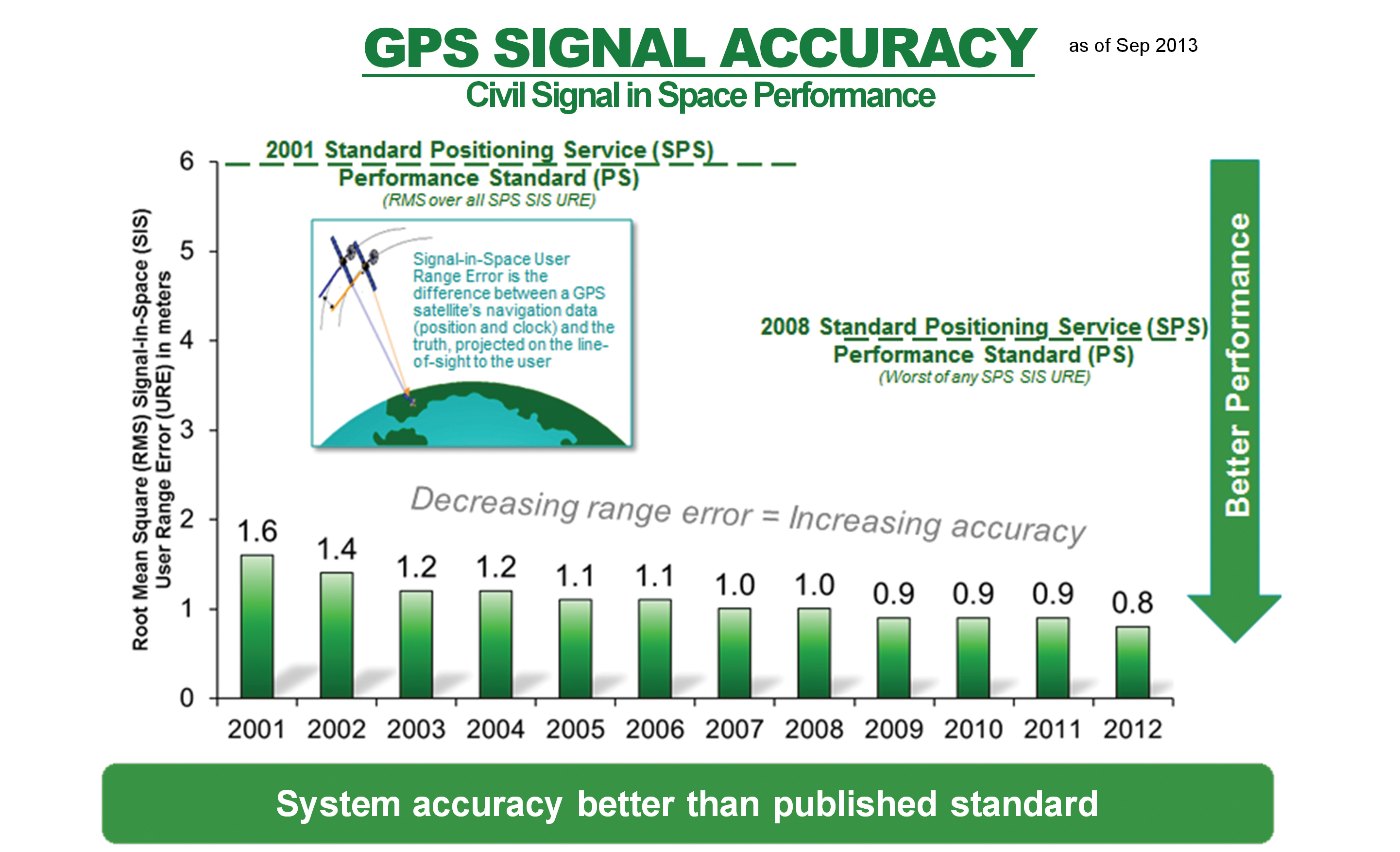
    The first commitment, arguably the most important for users everywhere, is the commitment to high accuracy for space-based PNT. After speaking at the ION GNSS+ conference and meeting many of you in Nashville this September, I realized that some users remain worried that selective availability (SA) — the intentional degradation of public GPS signals — could return and negatively impact GPS signal quality. SA was discontinued in May 2000 to provide an increased level of accuracy to all users around the globe. Since that time, the U.S. government has adopted a policy to no longer use SA and, furthermore, in 2007 removed that function from the upcoming GPS III satellites. The GPS Performance Standard for the Standard Positioning Service reflects our commitment to accuracy by ensuring the signal-in-space (SIS) user range error remains low: better than 4-meter accuracy. Figure 1 shows the record-setting SIS accuracy and how GPS meets and far exceeds this guarantee: consistently better than 1-meter accuracy! The 2 SOPS operators who command and control the GPS satellites do a masterful job ensuring global PNT accuracy is as good as it can be.

    Figure 1. Standard Positioning Service signal-in-space performance.
    Figure 1. Standard Positioning Service signal-in-space performance.

    The quality of these services, however, does not permit the GPS enterprise to rest in the comfort of past success. We are dedicated to updating and modernizing the program.

    The second commitment I’d like to highlight includes the GPS pledge for constellation sustainment and service availability. This is a guarantee to maintain a constellation of at least 24 satellites continuously broadcasting the GPS signals, providing a low dilution-of-precision value around the globe. Current efforts to meet this commitment range from replenishing unhealthy satellites to deploying improved, modernized satellites and corresponding ground support. For example, the GPS IIF satellites are rapidly becoming an integral part of the GPS constellation. With four IIFs on-orbit and a fifth soon to be launched, the constellation continues to exceed the 24-satellite requirement.

    The third commitment — to modernize the GPS constellation with new signals — is best illustrated by, but not limited to, the modernized GPS IIF and GPS III satellites that are beginning to populate the constellation. In addition to four GPS IIF satellites now on orbit, the remaining GPS IIFs are either ready for launch or in final testing.

    Down the road, GPS III satellites are completing development and progressing through early production. They will add the fourth civil signal, L1C, for civil users worldwide. Earlier this year, the GPS III program shipped the GPS non-flight satellite testbed (an engineering development unit) to Cape Canaveral; it successfully communicated with the next-generation operational control system (OCX), essentially as it would for launch and on-orbit check and control of functional GPS III satellites. The operational portion of the GPS ground segment, OCX Block 1 is on track to begin operations in 2016, modernizing the control segment by providing mission operation control of all legacy signals, as well as L2C and L5; later, OCX Block 2 will support L1C.

    GPS civil users will soon be able to take advantage of the L2C and L5 signals that broadcast the modernized civil navigation message (CNAV); this will effectively eliminate the need to access the L1 and L2 P(Y) signals through codeless or semi-codeless techniques. These codes permit civil users to access dual-frequency solutions for precision applications (using dual-frequency enables ionospheric corrections for highly accurate PNT solutions). Compared to the L1 C/A signal, L2C features faster signal acquisition, enhanced reliability, and greater operating range. L5 will provide for increased safety-of-life applications with broadcast power even greater than L1 C/A and L2C combined, increased bandwidth, and advanced signal design. Regardless of the early availability of L2C and L5, semi-codeless users will be able to access P(Y) code — unhindered and unaffected by fully tested and vetted flex-power operations — until the end of 2020. Overall, these modernization efforts emphasize a commitment that availability surpasses simply putting satellites on orbit.

    Finally, the GPS Directorate is committed to providing a high-quality service that is highly reliable. We achieve this by fielding first-rate satellites, conducting extensive test campaigns before deploying new capabilities or launching new satellites, and working closely with the operators at 2 SOPS, ensuring our constellation delivers top-quality PNT signals. An example of diligent testing is the recent live-sky test of the CNAV message on all GPS IIR-M and IIF satellites this past June. An example of a modernization feature that will enhance reliability is the capability of GPS III satellites to autonomously monitor the atomic clocks that drive the signal, thereby protecting users from clock instability and resulting signal errors.

    Our demonstrated commitment to deliver accurate, available, and reliable space-based PNT allows innovators around the world to invest confidently in the creation of a multitude of GPS and GPS-enabled technologies that shape the way we live. GPS and its related technologies go far beyond letting you find the deli down the street and “checking in” to let your friends know what you’re up to on Facebook; it tracks financial transactions, enables precision farming, and allows accurate real-time updates on natural disasters such as earthquakes and tsunamis with capabilities that organizations like the NASA Jet Propulsion Laboratory and the International GNSS Service provide using GPS. The GPS Directorate is keenly aware that innovators invest their time and talent because they know they can depend on GPS availability. Our commitments are not just “feel-good” words; they are our mission and promise to the world.

    I am very proud of the men and women in the GPS Directorate and thrilled to be part of this great team as the new GPS program director. The commitments listed here provide a glimpse into the services provided by the GPS enterprise. I am excited about bringing modernized signals to the world, but more excited to learn how the PNT community will use these signals to develop new innovative and useful applications. The world is easier to navigate because of GPS and GPS-enabled technologies, all of which rely on services the GPS enterprise provides: accuracy, availability, and reliability. We are committed to delivering these services as we modernize and improve the enterprise to continue GPS as the gold standard of space-based PNT.


    Colonel William L. cooley is Director, Global Positioning Systems (GPS) Directorate, Space and Missile Systems Center, Air Force Space Command, Los Angeles Air Force Base, California.

  • Public Geolocation Vault on the Horizon?

    Imagine a vault of highly accurate geolocation data that provides look-up service for any device, in any country, based on publicly sent signal data. It is an appealing idea. Mozilla, best known for its popular Firefox browser, is a nonprofit organization dedicated to openness on the web. No one is better positioned to create the very first public geolocation database. Mozilla wants to build the data service with the end goals of enabling innovation and improving location data privacy. The group makes the point that improving the privacy of user data is counter incentivizing for-profit companies that collect this data. Privacy continues to be a major industry issue that has gotten more than one company in trouble with regulators and customers.

    Mozilla is starting out with a pilot project, named “Mozilla Location Service,” to assess how it would build and operate a location service to provide geolocation look-up for devices. The data will be based on publicly observed cell tower, Wi-Fi or IP address information. Mozilla is enlisting its loyal community to collect the data via a special app for Android-based phones.

    Admitting Wrongness. Those of us who skewered Apple for its map troubles continue to eat crow. The Apple maps have improved and are popular, or at least good enough, with most iPhone and iPad users in the U.S. As you may recall, Google maps were expelled from the iPhone when Google refused to give Apple access to its turn-by-turn navigation. Google, who had delighted in Apple’s map debacle, has now been badly humbled. The company has lost almost 23 million mobile users in the U.S. as a result of its banishment. iOS users can still assess Google Maps, but data from market research firm ComScore suggests that few actually take the trouble to download Google Maps. When iOS 6 began to roll out and introduced Apple’s maps as the default, the number using Google Maps dropped precipitously, even as the number of iPhones and Android phones began rising.

    Big Money from Mapping. The value of being a map provider cannot be underestimated. Both Apple and Google cull anonymous data for traffic reporting and improving their network. More importantly, they have created a gold mine by using the data to glean for behavioral information about users. The data is fed to advertisers who create contextual ads that are more likely to get us to buy. Google also uses the data to improve search results.

    Good news for the Enterprise Industry. A survey of 500 fleet operators conducted by C.J. Driscoll and Associates shows high satisfaction and strong intent to purchase GPS fleet management systems. From an enterprise customer’s standpoint, GPS-enabled solutions are measured by how quickly the company can recoup its outlay. An impressive two thirds of the fleets surveyed reported that they have recouped their investment in their GPS fleet solutions. Of the fleets that haven’t deployed a GPS fleet management system, 16 percent indicated that they expect to do so within the next 18 months. The fleet survey is contained in the C.J. Driscoll 2013-14 Survey of Fleet Operator Interest in MRM Systems and Services report.

    The Final Frontier: Indoor Location. Applications are increasingly hungry for ubiquitous, well-performing location for all devices. Sensor fusion, or the intelligent combination of data from multiple sensors, will become a standard feature to help make this happen in indoor locales. “Sensor fusion will surpass Wi-Fi and Bluetooth low energy (BLE) as the most important handset-based indoor location technology by 2017,” predicts Patrick Connolly of ABI Research. “We see a significant trend towards hybridization, with Wi-Fi, BLE, and sensor fusion proving to be vital.” Companies in this market include Movea, HillCrest, indoo.rs, and Senionlab.

    Wind Blowing in New Direction. PlaceIQ, the location context company, has ventured into location-based behavior analytics. The start-up company had been focused on providing information on the context of location in small geographic areas, 100 by 100 square meter units. One of the company’s new offerings, PIQ Analytics, “can identify which competitors a brand’s audience is most likely to visit, the restaurants where they typically dine, the type of device they use, and the stores that they frequent,” reports the PlaceIQ website. The company’s other new product tracks individuals and “determines where consumers were before arriving at a brand’s physical location.” PlaceIQ is going to have to careful how it treads this ground, if it wants to avoid raising opposition from privacy watchdog groups.

    Mapping Sadness  As you may have heard, a father has discovered that Google Maps shows the body of his son, who was shot to death in 2009 beside a railroad track in Richmond, California. In a written statement, Google announced that it would accelerate the replacement of the satellite image of the map, the first time that it made such a change due to a request. Google indicated would take about eight days to make the change, as the image has continued to be visible on their maps. Perhaps a reader can explain to me why replacing this map segment would take so long, or why the image could not have been obscured by Google until the replacement is made?

    I will be moderating a session at the IEEE International Conference on Connected Vehicles and Expo on December 5 in Las Vegas. The SAE-organized panel is on Connected Infotainment. The panelist are industry experts who will share perspectives in this interactive session.

  • Companies Looking to Profit with Niche Fleet Markets

    Companies Looking to Profit with Niche Fleet Markets

    Logo: American Towman ExpositionNiche markets for location companies are sometimes hit-and-miss. One real opportunity that is gaining more traction among location companies is towing. There are legions of Duck Dynasty-type of towing trade show attendees, but you shouldn’t judge a book by its cover. There is tons of money in the towing industry as banks, insurance companies, motor clubs and other technology entities are flocking to these shows. Many times that scruffy-looking guy in a Duck Dynasty T-shirt is a multi-million-dollar owner of a big towing company. Companies such as Verizon are ramping up their fleet opportunities for more conventional markets, which leads one to say, once again, that the fleet, mobile resource management market is still growing and lucrative.

    BALTIMORE — Although it is a strong niche market, the towing industry is gaining traction among the dozen or so location companies that were exhibing at the recent American Towman Exposition here.

    Location companies exhibiting asked towing operators to look at the usual benefits of their products: fuel savings, dispatching tow trucks to the nearest incident, reducing idle time, reduced overtime hours, monitoring of speeds and other features. The location companies present were TomTom, Teletrac, Fleetmatics, Progressive Platforms and others.

    Several financial institutions were on site who acknowledged the importance of tracking and monitoring technology in towing company fleets and headquarters. One banker said that he will not give a loan to a towing company unless it has, across a fleet, a real-time tracking system. The same goes for many insurance companies.

    TomTom Business Solutions is offering its Webfleet product to tow companies. The company recently integrated the unit with Service Station Computer Systems Digital Dispatch software to reduce administrative tasks between an office and tower site. At the conference, towing software and services companies such as FTI Groups are integrating location company products from BudgetGPS, Geotab, TomTom and sureFleet Mobile into their offerings for transportation markets.

    One challenge that location companies may have in smaller niche markets is volume. One company says it cannot sell to fleets with five or fewer trucks.

    Verizon Partnering with Samsung and XRS on Trucking Product

    Verizon recently partnered with Samsung Telecommunications America and XRS Corp. on a mobile software product, called NXT, for the transportation industry. The unit uses Verizon’s 4G LTE network and works on Samsung Mobile’s devices.

    NXT allows drivers and fleets to use Samsung Mobile devices with an XRS trucking software subscription. The unit is available on the Samsung Galaxy Tab 7.0 and has a $54 per month data and subscription plan. Other fees include $39 for a monthly XRS fee and $15 for wireless data.

    The NXT rollout doesn’t affect sales or shift away from in-vehicle hardware now offered by Verizon, said Michael Toto, Verizon Enterprise Solutions director of strategic global alliances. “We view this as a complementary addition, not a shift away from our in-vehicle solutions,” he said.

    Toto says that the company’s partnerships, with Samsung and XRS, allow Verizon to provide a broader portfolio that allows its customers more business options. With best-in-class partnerships, such as Samsung and XRS, it can provide a broader solution portfolio allowing its customers to select a solution that closely matches business needs.

    Toto believes the NXT deal is a big deal and differentiates Verizon from other wireless carriers’ fleet offerings. “NXT is a game changer in the fleet industry because it is a comprehensive solution to help transportation companies be MAP 21 compliant,” he said. “The elements are available separately, but have never been offered before as a complete end-to-end solution.”

    Toto says Verizon provides high-speed wireless connectivity right now for operators. “Tomorrow we will further integrate the solution with Verizon technologies,” he said.

    Echoing what Toto said, NXT also offers integration with many enterprise transportation products. Over time, the platform collaboration will expand to introduce additional components, including MDM and wearable products, the companies said in a prepared statement.

    The product, which was developed through the Samsung Solutions Exchange program, works in both over-the-road and private carrier configurations — and according to the companies — is tailored to fleets of all sizes. The companies say that since the unit works on certified smartphones, tablets and handhelds, it allows companies to comply with the pending Electronic Logging Device, or ELD, mandate for recording driver’s hours-of-service.

    In other location news:

    • The Federal Communications Commission (FCC) recently said that more than two-thirds of the calls to 911 emergency centers in Texas from wireless phones do not include the accurate location information necessary to find a caller in crisis. The data, provided to the FCC by state and local 911 agencies, show a dramatic drop in more accurate “Phase II” data in Texas from 67 percent of all wireless calls in January 2011 to just 33 percent in June 2013, despite a dramatic increase in cell phone calls over the same period.
    • C.J. Driscoll & Associates released a new multi-client marketing research study covering U.S. fleet operators with Mobile Resource Management systems and services. The 2013-14 Survey of Fleet Operator Interest in MRM Systems and Services assesses fleet operator interest in GPS fleet management, driver behavior management, and GPS-equipped handset/portable solutions for managing mobile workers. The study was partially funded by 14 companies, including major cellular carriers, GPS fleet management solution providers, suppliers of driver behavior management systems, and other leading telematics suppliers to the fleet market. The following are among the key findings of the study: More than three-fourths of the fleets that are using a GPS fleet management system reported a high level of satisfaction with their system and two-thirds reported that they have recouped their investment in the system. Another study finding indicates participating fleets that have never used a GPS fleet management system expect to deploy a system in the next 12-18 months.
    • MapQuest, which hasn’t gotten the publicity of Google Maps or Apple, recently rolled out a new mapping application, which was a nine-month project. The new mapping app features layers of information “around” a user such as coffee, bars, gas, banks and parking. The new app gets traffic updates on the fly and works more like a standard GPS system, according to published reports. MapQuest is still the number 3 mobile map provider, which is a quiet stat given how long the company has been around in the location industry.
  • Qualcomm Collaborates with Samsung to be First to Employ BeiDou for Location-Based Mobile Data

    Qualcomm Incorporated has announced that its subsidiary, Qualcomm Technologies, Inc., is enhancing location precision in smartphones and tablets initially in China with support for China’s BeiDou Satellite Navigation System.

    Supporting the BeiDou constellation within Qualcomm IZat location solutions increases the number of satellites that Qualcomm-based devices can access to provide greater position location accuracy. Qualcomm is collaborating with Samsung to launch the first wave of BeiDou enhanced consumer smartphones, demonstrating the commitment of the companies to provide technology that delivers optimum performance for location-based services within China and globally.

    Powered by the Qualcomm Snapdragon 800 processor (MSM8974), the Samsung Galaxy Note 3 (WCDMA 3G version SM-N9006 & TD-LTE 4G version SM-N9008V) uses the industry’s first, integrated tri-band location platform to provide more accurate and responsive location data to mobile users. It does so by concurrently processing signals from multiple satellite networks. Armed with this capability, users will have more enjoyable experiences using their location-based services, even in the most challenging of environments.

    Leveraging Qualcomm IZat location solutions, Samsung will be able to deliver an optimal user experience with quick and accurate location information and services in China. Historically, this has been a challenge in some locations, especially in urban canyons, where devices may suffer from low visibility to satellites blocked by tall buildings that obstruct the signals. Bringing BeiDou-enabled phones to China means the Galaxy Note 3 has access to more satellites, which increases location accuracy. This ultimately improves customers’ pedestrian navigation, speeds local searches and enhances other location-based services.

    Qualcomm’s mobile chipsets feature interoperability with existing constellations, which use tri-band hardware integration to deliver improved location capabilities in an optimal way, with enhanced accuracy, and with no additional increase in power consumption. In Snapdragon and Gobi™ chipsets, global positioning support is built into the modem and RF chips, enabling the location signals to be processed in the modem, instead of waking up the apps processor, thus saving power without sacrificing location accuracy.

    “This industry-first implementation of BeiDou in a smartphone underscores Qualcomm’s leadership in the location industry. More than 3 billion devices which feature Qualcomm’s location technology have shipped to date and the introduction of BeiDou is the latest step to evolve our technology,” said Amir Faintuch, president, Qualcomm Atheros. “We see BeiDou’s support being an important factor for OEMs in China, and globally as well. With this new location enhancement, we believe our customers can bring greater differentiation with advanced performance, applications and services.”

  • SPOT Offers Trace Theft-Alert Tracking Device

    SPOT Offers Trace Theft-Alert Tracking Device

    SPOT Trace
    SPOT Trace

    SPOT LLC, a wholly owned subsidiary of Globalstar, Inc., has launched its SPOT Trace anti-theft asset tracking device. SPOT Trace ensures cars, motorcycles, boats, ATVs, snowmobiles and other valuable assets are where they need to be, notifying owners via email or text when movement is detected anytime, anywhere. SPOT’s growing family of products uses 100% satellite technology to provide location-based messaging and emergency notification for on or off the grid communications.

    SPOT Trace users can view their boat, ATV, motorcycle or other asset’s GPS coordinates online 24 hours a day in near real-time through Google Maps. With multiple mounting options, SPOT Trace is small and durable enough to be placed practically anywhere. With up to 18 months of battery life, affordable rate plans and satellite coverage that goes beyond the reach of cellular coverage, there is no comparable product on the market to track anything, anytime, anywhere. Other SPOT Trace features include:

    • Tracking. View your asset’s GPS coordinates from your smartphone or online
    • Movement Alerts. Receive texts/emails when SPOT’s vibration sensor detects your asset has new movement
    • Dock Mode. Configure your device to track an asset that is primarily stored on the water
    • Power Off Message. Receive a notification if your device is powered off
    • Low Battery Message. Receive a notification when the device’s batteries are low
    • Status Message. Receive a once per day alert to let you know your asset is secure

    SPOT Trace also features customizable tracking, which allows users to track an asset’s GPS coordinates at 2 1/2, 5, 10, 30 or 60 minute
    intervals. The units will sell starting at $99.95, with service plans from $99.99/year.

  • 1 Billion Smartphones with Location-Based Sensor Fusion Expected by 2016

    As smartphones embrace always-on, ubiquitous location, location-based sensor fusion will become a standard feature. ABI Research’s report, “Location-based Sensor Fusion: Companies, Technologies, and Revenue Opportunities,” outlines how sensor fusion will evolve to support indoor location and the companies best placed to succeed in this space. Location-based sensor fusion will enable the dawn of the quantified self, ambient intelligence, as well as provide huge potential around advertising and retail, ABI Research said.

    Senior analyst Patrick Connolly comments, “Sensor fusion is vital in enabling a consistent location experience, RF mapping, and the industry to scale rapidly. Unfortunately, it is not just a case of putting in a 9-axis sensor to achieve this. Highly complex algorithms are required to optimize sensor outputs, integrate with other location technologies and combine with machine learning and data-fusion algorithms. Sensor fusion will surpass Wi-Fi and BLE as the most important handset-based indoor location technology by 2017.”

    ABI Research has forecast the adoption of different indoor location technologies, and the companies best placed to be successful. “We see a significant trend towards hybridization, with Wi-Fi, BLE, and senor fusion proving to be vital. By 2014, hybrid solutions will have already surpassed standalone indoor location technologies on smartphones. Longer term, technologies around optical light, object recognition, and LTE-direct are all forecast to offer differentiation,” continues Patrick Connolly.

    VP and practice director Dominique Bonte adds, “The market is largely divided between Sensor IC OEMs, GPS/connectivity IC OEMs, and a group of really interesting start-ups. Companies like Movea, HillCrest, indoo.rs, and Senionlab are creating some intriguing solutions and will represent the next generation of acquisitions and partnerships in indoor location.”

    These findings are part of ABI Research’s Location Devices Research Service, which includes Research Analyses, Market Data, Insights, Presentations, and Competitive Assessments focused on the indoor location market.

  • Verizon Expands Asset Tracking Portfolio with Networkfleet Asset Guard

    Verizon Enterprise Solutions today announced the expansion of its asset- tracking capabilities, with the introduction of Verizon Networkfleet Asset Guard. Designed to fit seamlessly on Verizon’s existing Networkfleet vehicle tracking solution, Networkfleet Asset Guard runs on the Verizon Wireless network for fixed and moveable fleets such as trailers, yellow iron machines and generators.

    A lightweight device with a built-in wireless antenna that easily attaches to a piece of equipment for wireless tracking, Verizon Networkfleet Asset Guard includes a long-lasting battery that allows for reliable location tracking over multiple years. Using Networkfleet’s online application, business owners can track assets alongside fleet vehicles to determine exact GPS locations. Reports and alerts show if and when an asset has been moved, which asset is closest to a particular location or landmark and when assets are moved outside of a predetermined virtual perimeter, or geofence.

    “It is becoming more critical for businesses and other organizations to track all of their vital assets, including equipment and vehicles, to help maintain security and operational efficiency,” said Erik Goldman, group president, Verizon Telematics. “With Networkfleet Asset Guard, businesses and government agencies can easily locate their fleet assets and together with our other Networkfleet solutions make sure they are being used properly and efficiently. The combination of Asset Guard’s long battery life coupled with the variety of reports and alerts will help public- and private-sector organizations improve equipment utilization, better manage fleet operations and control costs.”

  • Kinexon Wins 10th European Satellite Navigation Competition with Athlete Tracking Analysis

    Kinexon Wins 10th European Satellite Navigation Competition with Athlete Tracking Analysis

    Photo: Kinexon

    Online analysis of athletes’ tactical, technical, and physical capability is the focus of this year’s newly named Galileo Master, Kinexon GmbH.

    The 10th European Satellite Navigation Competition (ESNC) recognized the best products, services, and innovations that facilitate the use of satellite navigation in everyday life. At the 2013 awards ceremony, prizes worth a total of about EUR 1 million were presented in 32 categories. The ceremony helped kick off the European Space Solutions conference, which is taking place November 5-7 at Alte Kongresshalle München.

    ESNC 2013 gave participants from all around the world the chance to vie for any one of 25 regional prizes. In addition, topic-specific special prizes were sponsored by the following partners: the European GNSS Agency (GSA), the European Space Agency (ESA), the German Aerospace Center (DLR), and — for the first time this year — the European Patent Office (EPO) and Metaio GmbH. Students and research assistants were also encouraged to submit their ideas to the ESNC University Challenge.

    Athletic analysis is playing an increasingly important role in modern sport training. The underlying idea — known as the Hawthorne effect — is simple: if you can measure your performance, you can also improve it. Following this principle, two research assistants from Technische Universität München (Germany) founded the company Kinexon GmbH at the ESA Business Incubation Centre Bavaria and developed a cloud-based solution for analyzing and visualizing training data on mobile devices.

    Kinexon’s solution kits athletes out with a small, portable location sensor and feeds the resulting data into the cloud by means of a stationary base antenna. This enables users to track and analyze performance parameters and tactical movements down to the centimeter in real time.

    In particular, however, it was the solution’s user-friendliness during training and relatively low cost (compared to the camera-based systems commonly seen today) that won over the international jury of experts in the European Satellite Navigation Competition. So far, the high price of such systems has limited their use to professional sport; Kinexon’s system will now give amateur clubs the chance to benefit from adding online analysis to their training activities, as well.

    Along with the sport sector, this flexible satellite-based localization system also exhibits huge potential in tapping into further markets, including healthcare, logistics, and unmanned aerial vehicles (UAVs). “We’re pleased to be supporting Kinexon at ESA BIC Bavaria,” affirms Thorsten Rudolph, CEO of Anwendungszentrum GmbH Oberpfaffenhofen. The Kinexon system, the first version of which is set for market launch in November 2013, managed to edge out more than 400 other ESNC entries from nearly 50 countries.

    Gerd Gruppe, member of the Executive Board, German Aerospace Center (DLR), conferred the EUR 20,000 grand prize on Kinexon GmbH founders Oliver Trinchera and Alexander Hüttenbrink.

    “DLR sets great store in technology transfer,” Gruppe said. “After all, innovations form the basis of economic success and hold considerable potential for society. The ESNC has developed into a driving force behind the innovative use of satellite navigation technologies and a starting point for numerous successful start-ups in Germany, Europe, and the rest of the world.”

    Winners of the 10th European Satellite Navigation Competition

    In addition to the overall winner, the Galileo Master, the 10th European Satellite Navigation Competition rewarded Special Prizes in seven different categories and 25 prizes to regional winners.

    Special Prize Winners 2013 
    GSA :: The most promising EGNOS application idea
    Jelle Reichert, JOHAN, The Netherlands :: JOHAN: the Digital Oracle for Field Sports, Including GNSS Player Tracking in Real Time
    Keywords: Mobile Location Based Services, sports,  real-time tracking, health
    ESA Innovation Prize & 2nd in Overall Ranking
    Jan Walter Schroeder and team, SenSovo, Germany :: Sensovo Navipal: A New Way to Feel Directions
    Keywords: tactile navigation, wearable technology, tourism, outdoor sports, visually impaired
    DLR :: Robust GNSS – Safety for Success
    Bastiaan Ober and John Wilde, Integricom, DW International, The Netherlands :: Galileo-Based Ionospheric and Interference Monitoring for Aviation
    Keywords: signal security, real-time monitoring, aviation,  interference
    EPO :: Best Patented Innovation
    Gaël Scot and team, CNES, France :: Two Patents for Improved Galileo System Performance
    Keywords: signal security, patents, high-end GNSS receivers
    Metaio :: The most innovative location-based Augmented Reality application
    Steve Lee and team, Stevenson Astrosat, United Kingdom :: WinterVision: Augmented Reality for Winter Road Safety
    Keywords: augmented reality, road safety, driver assistance system, emergency response
    University Challenge & Portugal
    Luis Gomes and Filipe Sousa, Outcapsa, Portugal :: GeoAgenda: Innovative Geo-located Agenda Concept
    Keywords: LBS, smart personal organiser, meeting tool
    GNSS Living LabPrize & North Rhine-Westphalia / Germany & 3rd in Overall Ranking
    Adalbert Rajca and Yasotharan Pakasathanan , ampido GmbH, Germany :: Ampido: The Car Park in Your Pocket
    Keywords: Location Based Services, smart city application, park-sharing, share economy


    Regional Prize Winners 2013
    Aquitaine/France
    Romain Desplats and team, CNES, France :: Physiotrack: Track Your Physical Progress
    Keywords: sports tracking, health, performance monitoring, physical exercise forecast
     Arab Middle East & North Africa (MENA)
    Hussain Saleh, Ghent University, Belgium :: A Generic GNSS Network for Disaster MonitoringKeywords: emergency management, disaster monitoring, big data, artificial intelligence
    Austria
    Dr Clemens Strauß and Gernot Hollinger, Strauß & Hollinger : GeoIT OG, Austria :: ENViGUARD: The App That Helps Keep Your City Clean
    Keywords: smart waste management, crowdsourcing, LBS, public health, pollution control, environmental protection
    Baden-Württemberg / Germany
    Erich Franke and team,  AFUSOFT Kommunikationstechnik GmbH, Germany :: SaltHawk: Innovative Winter Road Safety System
    Keywords:  road safety, environmental protection, road service management
    Bavaria / Germany & Overall Winner
    Dr Oliver Trinchera and Dr Alexander Hüttenbrink , KINEXON GmbH, Germany :: KINEXON: Precise Localisation and Sports Monitoring
    Keywords: precise tracking, wearable technology, sports, health, logistics
    Bulgaria
    Nikolay Staykov and team, Mobilly, Bulgaria :: Mobilly: A Next-Generation Travel Planner
    Keywords: LBS, travel planner, local discount campaigns, couponing
    Catalonia / Spain
    Rafael Olmedo and Carlos Barreto, GEKO NAVSAT, SpainNAVMATE: The Low-Cost Safety Solution for the Great Outdoors
    Keywords: wearable technology, emergency management, outdoor navigation, outdoor sports
    Czech Republic
    Jiří Mikoláš and team, Be interactive, Czech Republic :: Augmented Prague: The Innovative Sight Seeing App
    Keywords: Augmented Reality, AR, LBS, tourism, city guide


    Estonia
    Mari Loorman, Estonia :: LASIK: Optimising Children’s Physical Activity
    Keywords: children’s health, physical activity, computer addiction
    Flanders / Belgium
    Joeri Spitaels and team, QraQon, Belgium :: Winnetou: Improved Security for Freight Wagons
    Keywords: freight tracking, transport security, solar-powered
    Gipuzkoa / Spain
    Jon Sánchez Ugarte, OnSiteBIM, Spain :: BimOn! Making Building Smarter with AR
    Keywords: Augmented Reality, AR, construction sites, building models, LBS
    Hesse / Germany & 3rd in Overall Ranking
    Lukas Wagner and team, Notificatio UG, Germany:: AlarmApp: Location-based Emergency Notification System
    Keywords: emergency management, volunteer fire fighters, LBS
    Ireland
    Paula Kelleher and James Mannix, Geomanics Ltd, Ireland :: CarSafari: Every Trip an Adventure
    Keywords: in-car entertainment, tourism, education, location-based advertising
    Japan
    Hitomi Inaba and team, University of Tokyo, Japan :: TrustSync: Secure Time and Frequency Synchronisation
    Keywords: high precision, signal security, synchronisation, GNSS receivers, financial networks
    Lithuania
    Saulius Rudys and Mantautas Rudys, Lithuania :: Improved Indoor and Underground Navigation Accuracy
    Keywords: indoor navigation, GNSS repeater, precise navigation
    Lombardy / Italy
    Mirko Antonini and Alessandro Di Felice, SpaceEXE Srl, Italy :: COPPI: Monitoring and Tracking of Cyclists
    Keywords: professional cycling teams, sports tracking, health, real-time performance monitoring
    Mexico
    Victor Jose Gatica-Acevedo and team, National Polytechnic Institute, Mexico :: AMBER Alert: Recovering Lost Children Through GNSS Integration
    Keywords: seach and rescue, LBS, notification, tracking
    The Netherlands
    Willem Folkers, Folkline, The Netherlands :: The Anti-Spoofing GNSS Receiver
    Keywords: signal security, safety critical applications, Galileo PRS (public regulated service)
    Nice-Sophia Antipolis / France
    Yann Hervouet and team, Instant System, France :: Real-Time Solutions for Public Transport PassengersKeywords: real-time trip planner, smart public transport, real-time schedule information
    North Rhine-Westphalia / Germany & GNSS Living Lab Prize & 3rd in Overall Ranking
    Adalbert Rajca and Yasotharan Pakasathanan , ampido GmbH, Germany :: Ampido: The Car Park in Your Pocket
    Keywords: Location Based Services, smart city application, park-sharing, share economy
    NorwayHarald Skinnemoen and team, AnsuR, Norway :: GNSS-Enabled Do-It-Yourself Insurance Claims                 
    Keywords: LBS, insurance claims, geo-tagged images, crowdsourcing
    Øresund / Denmark & Sweden
    Andreas Ekengren and team, PingPal AB, Sweden :: Pingpal: Privacy-Protected Positioning for Your App
    Keywords: social networking, cloud solution, privacy protection
    Portugal & University Challenge
    Luis Gomes and Filipe Sousa, Outcapsa, Portugal :: GeoAgenda: Innovative Geo-located Agenda Concept
    Keywords: LBS, smart personal organiser, meeting tool
    Switzerland
    Che-Tsung Lin and team, Industrial Technology Research Institute, Taiwan :: See Through: Driving as You’ve Never Seen Before
    Keywords: driver assistance, V2V communication, road saftey
    United Kingdom
    Georgios Michalakidis and team, ManagePlaces Limited, United Kingdom :: ManagePlaces: Location-Based Project Management
    Keywords: field staff management, LBS, mobile workflow management, cloud solution


  • Sonata Advertising Platform Brings Online Customers  to Bricks-and-Mortar Stores

    Sonata Advertising Platform Brings Online Customers to Bricks-and-Mortar Stores

    Sonata
    Sonata is a self-service advertising platform for the retail world.

    Currently, 96 percent of world trade takes place through traditional brick and mortar stores. Add almost 1,000 million smartphones with integrated GPS to that retailing picture and a whole range of advertising opportunities, with high added value for advertisers and consumers, opens up. Sonata was begun l to drive foot traffic to local retailers’ point of sale via potential customers’ smartphones.

    Sonata divides the world into 90-square-metre plots. The plots are uploaded with local business adverts, which then appear on smartphones and tablets that come in range of the advertiser according to the smartphone’s geolocation. Sonata has been developed by TAPTAP Networks, a Spanish mobile advertising market leader based in Madrid.

    The process of uploading an advertising campaign is very simple for the retailer and takes no more than three minutes, according to Sonata. A retailer doesn’t need a website or even a mobile app; all that’s required is a minimum investment of £50. Advertisers follow three steps:

    1. registration using an email address;
    2. adding the store details (just one or a whole network);
    3. choosing the ad’s geographical area and the design of the ad from one of Sonata’s creative templates (or advertisers can create their own design).

    “Any local business, including those without technical know-how, can create an advertising campaign,” says Alvaro del Castillo, CEO of TAPTAP Networks and the developers of Sonata.

    “An added attraction of Sonata is that local businesses only pay for actual results-calls, registrations, clicks, purchases in the store… whatever form of contact a customer makes-and can choose how much to pay for them,” says del Castillo.

    “The Sonata platform is focused on meeting the need of the local small-business sector, which views the online world as a major threat with the ever-growing pressure it exerts from ‘showrooming’ and the selling of cost price goods by major e-commerce players,” explained de Castillo.

  • ABI Research: MEMS Sensors and Hands-Free Interfaces Will Revolutionize Mobile Devices

    ABI Research: MEMS Sensors and Hands-Free Interfaces Will Revolutionize Mobile Devices

    Photo: ABI Research

    Accelerometers, gyroscopes, near field communications (NFC), and gesture recognition are predicted to be the big winners in mobile devices. These mobile technologies are projected to make the greatest penetration gains over the coming years, according to a recent study by market intelligence firm ABI Research.

    “Hands-free operation or gesture recognition is soon going to become a key differentiator in high-end flagship smartphones, media tablets, and smart glasses,” says senior analyst Joshua Flood. “Samsung’s latest Galaxy S4 has already incorporated the technology within its handset and has received significant plaudits for its new innovative user experience. Furthermore, with a host of new smart glass products soon to be released, it is easy to imagine the usefulness of the interface with this product.” In 2013, almost 12% of smartphones shipped will have vision-based gesture recognition capabilities.

    Accelerometers and gyroscopes play a crucial role with today’s mobile devices, enabling devices to be more intuitive and take action without a user pressing a button. Simple actions like switching from portrait to landscape when a smartphone is tilted are made possible by including these components. Additionally, the fast growing mobile gaming market is highly dependent upon smartphones including gyroscopes, which enhance gaming experience. Nearly half of the smartphones shipped this year will include these MEMS sensor types.

    NFC has been one of the most talked about mobile technologies that has not quite taken off. The technology has primarily been focused around mobile payments; however, mobile OEMs have begun to see other potential capabilities for the technology such as photo-sharing and location information tag points that could open a huge market for advertising and marketing campaigns. Within three years, it is anticipated one in two smartphones shipped will include NFC and have gesture recognition capabilities. Furthermore, accelerometers and gyroscopes will be the “norm” with most smartphones.

    These findings are part of ABI Research’s Next Generation Mobile Devices and Mobile Handset Go-to-market Strategies Research Services.

  • Kipo, Tigo Enter Alliance to Offer GPS Location Software to Cell Phones

    Kipo, a GPS mobile location technology company targeting businesses and families, and Tigo Business Guatemala, a  telecommunications company, announced their partnership to launch Localizador Tigo. Localizador Tigo is a smart, user-friendly location platform that allows any type of mobile device to connect to the web and trigger actions by predetermined rules, the companies said.

    Triggers include location (arrival, exit, stay) and device events such as battery consumption and speed. Rules determine how the event will trigger and the action to take — send an email, post on social networks, mark a calendar, send an SMS, among others. For example, a company can create a rule that notifies a manager when his messenger delivers paperwork. Every time the messenger arrives to a specific location, the manager would receive an automatic email from the software. The sales manager could also create a rule to identify every time the sales team members have less than 10 percent battery. Once a device runs low on battery the manager would receive an automatic SMS to his mobile device.

    The technology also lets team members check in and leave comments when they arrive with clients, information that can be seen in real-time on the web alongside a complete suite of reports to make cell phone devices more useful than ever before. The product can work with any mobile device — smartphones will be able to access the service through native applications and feature phones will rely on cell-towers to report location.

    Localizador Tigo gives customers full ownership and control over their data and eliminating contracts, giving them the liberty to cancel service at any time. The product will be launched initially for corporate clients of Tigo Business and will be offered to individual customers on a later phase.

    “We believe GPS location technology should be smarter and easier to use. This alliance with Tigo Business makes real-time GPS technology accessible to millions of Tigo customers, which is great because we are allowing more people than ever before receive the benefits this technology provides,” said Rodrigo Blanco, founder and co-CEO of Kipo, Inc.

    “In Tigo Business we are always looking to provide our clients with the best and the most advanced tools so they can operate efficiently. We had been searching globally for the leading geolocation platform to incorporate to our mobile devices, and to our surprise we found it in a Guatemalan startup. The Kipo platform is functional, targets the needs of Tigo Business clients and is easy to use. The partnership with Kipo is a perfect next step to continue innovating and offering preeminent products to our clients,” said Hector Jimenez, category manager of Tigo Business Guatemala.

  • GPS Sensor

    GPS Sensor

    CW46S-ConnorWinfield-W
    The CW46S GPS sensor by NavSync.

    The CW46S GPS sensor by NavSync is a fully integrated module that includes a CW25 GPS receiver, DC/DC converter, RS232 or RS422 interface options, and active GPS antenna housed in a small weatherproof (IP67-rated) enclosure.
    When mounted with a good sky view, the CW46S receiver can provide high-quality timing and synchronization. The 1 pulse per second (PPS) timing signal can provide accuracies to within 30nS RMS of Coordinated Universal Time (UTC).

    The 1PPS is transmitted via RS422 signal format; this two-wire method allows the pulse to be transmitted with cable lengths exceeding 100 meters.

    The CW46S utilizes the CW25­TIM GPS receiver, which allows the CW46S to act as a complete timing module capable of outputting a GPS-disciplined 10-MHz frequency.