Türkiye is no stranger to earthquakes. In February 2023, a devastating 7.8-magnitude earthquake struck near the Türkiye-Syria border, followed by another nearly as strong.
Six Turkish universities have launched a real-time geodetic monitoring network to track earthquake-related ground deformation across Thrace and the Southern Marmara region, reports Hürriyet Daily News.
TR-TRAK-GNSS will monitor seismic and tectonic activity using 28 GNSS stations. The system is designed to evolve into a major scientific and early-warning infrastructure capable of detecting tectonic deformation in real time and identifying structural movements in buildings across cities and university campuses.
Once fully deployed, the network will form a continuous monitoring ring encircling Thrace and Southern Marmara.
The project will be financed through each participating university’s Scientific Research Projects resources, with institutions covering the installation costs of GNSS stations within their own areas of responsibility.
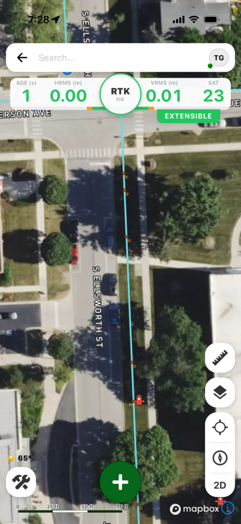
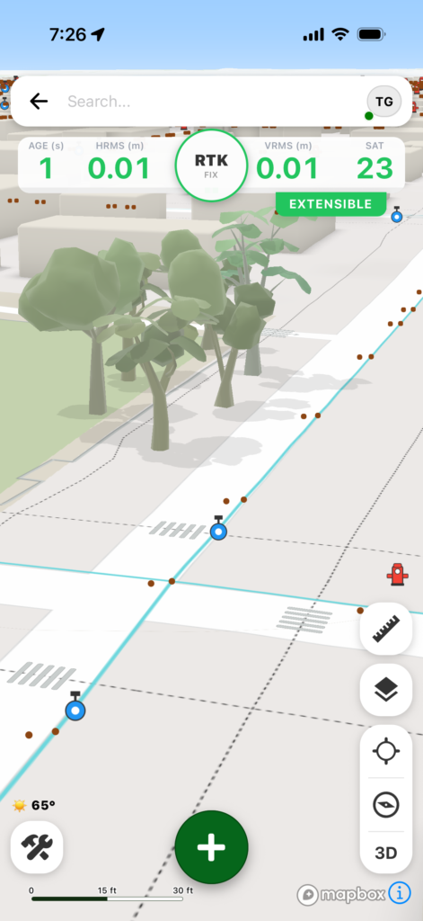
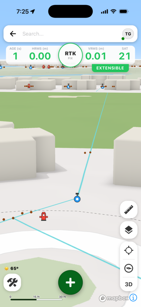
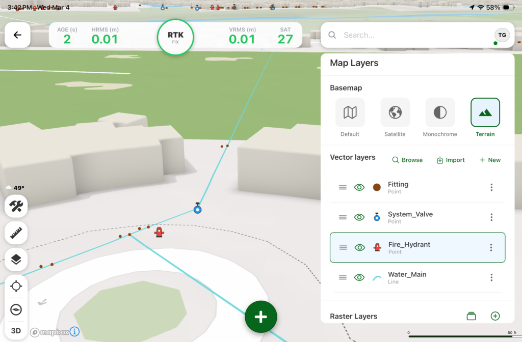
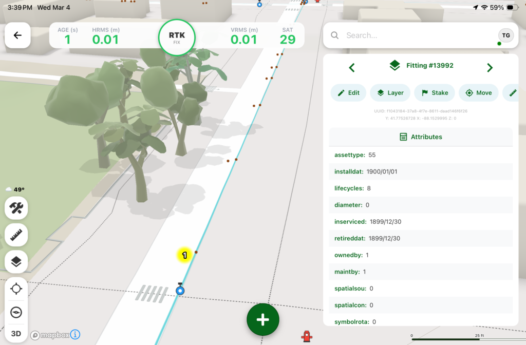
Digital Mapping Group, a pioneer in high-accuracy GNSS solutions for more than two decades, has released FastXY, a powerhouse mapping application for iOS and Android.
FastXY is designed to transform standard mobile devices into professional-grade data-collection tools for geospatial information system (GIS) and architecture, engineering and construction (AEC) professionals.
As the industry shifts away from bulky, proprietary hardware, FastXY offers professionals the ability to collect point, line and polygon data with the devices already in their pockets. Unlike “lite” mapping apps, FastXY delivers advanced capabilities including 3D basemaps, construction staking, topographic surveying, on-the-fly datum transformations, and survey-grade elevations.
Credit: Digital Mapping GroupCredit: Digital Mapping GroupCredit: Digital Mapping GroupCredit: Digital Mapping GroupCredit: Digital Mapping Group
One of FastXY’s most disruptive features is its built-in Bluetooth data parser. This allows users to configure the app to collect data from virtually any instrument supporting BLE Bluetooth or RS-232 — including echosounders, radiation sensors, laser rangefinders, barcode scanners and more — and marry that data instantly with precise GNSS coordinates.
“Our goal to create the most useful GNSS field data collection software for iOS/Android that uses the latest software tools,” said Ryan Skeele, software engineer. “The power of iOS/Android mobile devices increases every year, and we intend to iterate quickly to provide users more powerful solutions in the field.”
Available in two versions: Free and Premium
Essentials (free version)
High-accuracy ready. Works with device internal GNSS or Eos Positioning Systems’ Bluetooth receivers.
Offline-first approach. No internet connection required for field editing/data collection.
Rich visualization. 3D basemap featuring satellite, terrain and building overlays.
Smart logic. Attribute picklists with computational operations.
Survey-grade datum support. Real-time horizontal and vertical datum transformations.
Professional powerhouse (premium version)
Advanced point staking, auto-topographic data collection and cross track navigation.
Hardware integration. Full support for Eos Positioning Systems’ Skadi Tilt compensation and Smart Handle hardware.
Sensor hub. Connect to echosounders, laser rangefinders, barcode readers, radiation sensors, and other instruments with the external instrument configurator.
Advanced field workflow. Import Trimble Data Dictionaries, CAD/GIS files, KMZ/KML, and drone-captured raster imagery.
Post-processing. RINEX data collection and direct OPUS submission for static post-processing.
“We’re excited to offer an app for high-precision AEC users that runs on the mobile device in your pocket,” said Eric Gakstatter, principal GNSS consultant and former GPS World survey editor. “Separately, the unique Sensor Hub feature allows FastXY to consume data from almost any external instrument, combining it with high-precision GNSS data.”
FastXY is available for download today on the Apple App Store and Google Play. For more information, visit fastxy.com.
Digital Mapping Group
Founded 24 years ago, Digital Mapping Group has deployed tens of thousands of high-accuracy GNSS solutions globally. Their expertise spans utilities, public works, AEC, environmental, transportation and government sectors.
Austria is breaking new ground in space. BeaconSat is the largest satellite ever developed in Austria and also the country’s first military satellite. The project is being led by Austrian start-up GATE Space, based in Schwechat. Launch is planned for February 2027 aboard a SpaceX Falcon 9 rocket.
BeaconSat is designed to detect and analyze jamming and spoofing attacks on GNSS — targeted attempts to interfere with and manipulate navigation signals such as GPS or Galileo. Austria is responding to a security policy development that has real implications for aviation, transport, energy supply, and military operations.
Attacks on critical infrastructure
Jamming and spoofing incidents are frequent in geopolitically tense regions. In aviation, repeated disruptions have affected civilian aircraft.
“Space is now a central component of Europe’s and Austria’s security and defense strategy,” said Major General Friedrich Teichmann, head of the ICT and Cybersecurity Center. Navigation signals have long been part of critical infrastructure, and securing them is therefore of great strategic importance.
However, many of these attacks remain invisible. Countries often do not know where the interference is coming from, how systematic it is, or what pattern lies behind it. This is where BeaconSat comes in.
Technology demonstrator with strategic dimension
BeaconSat will systematically detect and analyze GNSS interference signals from orbit for the first time. The aim is to obtain data on when and where navigation systems are being deliberately disrupted. The mission is designed as a multi-year research and development project.
“It is important that we are able to act independently in terms of communication and navigation when necessary. This is a question of resilience and military capabilities,” emphasized Defense Minister Klaudia Tanner. “Space is an essential part of military capability.”
The satellite is not intended to be an isolated military project, but rather a demonstrator. Civil space technologies are being further developed for security-related applications and tested under real-world conditions. The findings will be incorporated into the operational processes of the Federal Ministry of Defense (BMVL).
Austrian industry at the center
GATE Space has overall responsibility for the project. Founded in 2022, the spin-off from TU Wien develops chemical propulsion systems for satellites and currently employs around 27 people. For BeaconSat, the company is supplying the propulsion system, the satellite structure, and the thermal management system, among other things.
“With BeaconSat, we are making a direct contribution to Europe’s security. The market for such capabilities is huge,” said Managing Director Moritz Novak.
The engines were tested in more than 8,000 hot runs at the site near Vienna Airport, both under atmospheric conditions and in one of Europe’s most powerful vacuum chambers.
GATE Space was supported by the Federal Ministry for Innovation, Mobility, and Infrastructure (BMIMI) through Austria Wirtschaftsservice (aws) with funding of around 750,000 euros.
Jamming and spoofing detection
A central contribution to the payload comes from the Graz-based company IGASPIN, which develops systems for the precise detection and analysis of GNSS interference. Additional components, including the on-board computer, are supplied by the Danish company Space Inventor.
At the European level, the mission is supported and co-financed as a technology demonstration via the European Space Agency’s ESA Marketplace. Off-the-shelf systems are specifically used to test commercially available technologies under security-relevant conditions.
New space chapter in the Ministry of Defense
BeaconSat also marks a turning point institutionally. The BMLV is currently setting up its own organizational unit for space services. The focus is on three areas: satellite communication, satellite navigation, and satellite-based reconnaissance.
“These space services are key to cross-domain operations and make a substantial contribution to the Austrian Armed Forces’ modern reconnaissance, command, and control network,” Teichmann said.
BeaconSat will provide data that will be directly integrated into military decision-making processes. At the same time, the project contributes to European resilience: those who recognize threats early on can respond diplomatically, politically, or technically.
Space as a growth area
The strategic importance of space technologies is growing both in terms of security policy and economics. Austria has recently increased its contribution to the ESA from 260 to 340 million despite budgetary constraints. Space and aviation technologies are anchored in the government’s industrial strategy as one of nine key technology fields.
Satellites have long been considered critical infrastructure. They enable navigation, communication, Earth observation, climate monitoring, and security applications. At the same time, new markets are emerging in the areas of propulsion systems, data analysis, and dual-use technologies.
With BeaconSat, Austria is repositioning itself in terms of security policy and industry. The project is an example of how startups, established technology companies, ministries, and European partners can and must work together successfully.
With full multi-constellation, multi-frequency GNSS signal protection, the GAJT-AE3 provides assured positioning, navigation and timing (PNT)
Hexagon | NovAtel has launched the latest addition to its battle-proven GNSS Anti-jam Antenna Technology (GAJT) lineup: GAJT-AE3. The GAJT-AE3 emerges in response to the escalating power and sophistication of jamming techniques that disrupt satellite-based navigation systems, a concern highlighted by current worldwide geopolitical conflicts.
As jammers become more powerful and low cost, with the capability of targeting a wider range of GNSS frequencies, there is a critical need for next-generation functionality and reliability.
To address this, the GAJT-AE3 protects all major GNSS constellations with full multi-constellation, multi-frequency coverage. This significant advancement in jamming protection — in a compact format — ensures reliable PNT in demanding airborne environments.
“This is a revolutionary expansion in our battle-proven anti-jam solutions designed specifically for space-constrained platforms,” said Stig Pedersen, president, Aerospace & Defence Division, Hexagon. “The GAJT-AE3 offers unparalleled signal coverage and multi-jammer direction finding for superior protection and heightened situational awareness.”
The GAJT-AE3’s antenna electronics mitigate interference by creating up to seven nulls per band in the direction of jammers, providing significant anti-jam protection even in dynamic multi-jammer scenarios. The output is a protected radio frequency signal, free from jamming and suitable for input to modern and legacy GNSS receivers.
Protecting and supporting all GNSS frequencies, including L-band corrections and Iridium PNT, the GAJT-AE3 is an easy-to-integrate, compact unit suitable for use on a variety of platforms, from UAVs to complex weapons. It can be paired with a range of antennas from the Hexagon | Antcom portfolio, including custom options.
Hexagon | NovAtel’s GAJT-AE3 is now commercially available.
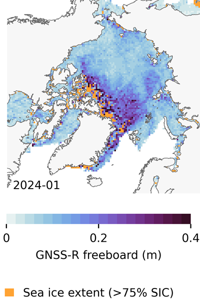
In recent years, scientists have shown that detecting changes in navigation signals from GPS and Galileo after they bounce off Earth’s surface (GNSS reflectometry, or GNSS-R) can deliver valuable information on sea ice. Now research drawing on data from Spire Global has enabled the generation of Arctic-wide sea ice maps, marking a major step forward for the emerging technique.
Spire Global‘s sea ice freeboard maps use data captured by Spire’s GNSS-reflectometry multipurpose listening constellation.
The research — enabled by the Third Party Missions (TPM) programme of the European Space Agency (ESA) — suggests that harnessing reflected navigation signals could become an important complement to established ice-monitoring altimetry missions.
The study leveraged Spire’s GNSS-R data to retrieve sea ice freeboard measurements across an entire winter season. The results show strong alignment with established altimetry datasets, including the ESA’s CryoSat mission, validating the complementary role of commercial satellite data alongside government missions.
Arctic-wide sea ice freeboard map for January 2024. (Credit: ESA)
The study was led by Felix Müller at the Technical University of Munich (DGFI-TUM) and Robert Ricker at the Norwegian Research Centre, experts in GNSS-R.
“The primary purpose of signals emitted from GNSS is to fix the location of a device at any point on Earth,” Müller explained. “However, when these signals bounce off Earth’s surface, their properties change. By analyzing these changes, we can infer information about the characteristics of Earth’s surface.”
“Previous research has shown that this technique works well experimentally,” Ricker added. “Using the Spire constellation, we aimed to demonstrate whether it would hold up on a larger scale by generating an Arctic-wide map of sea ice freeboard, which is a measure of how far ice protrudes above the waterline.”
Spire’s GNSS-R constellation
Spire’s constellation was first used to sample the atmosphere for weather forecasting. Then scientists began exploring other applications. Spire started collecting reflected signals arriving at shallow angles using a technique called grazing-angle GNSS-R. This method is particularly well suited for ice monitoring.
The research team analyzed data detected over the Arctic Ocean and surrounding seas between October 2023 and July 2024. The data was obtained via the TPM program, through which ESA disseminates data from a range of commercial and institutional partners on a free basis for research and development purposes.
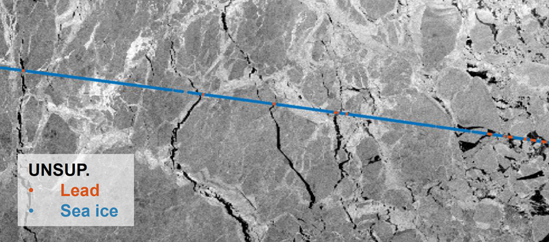
The team focused on one of the most critical challenges in sea ice altimetry: reliably identifying narrow openings in the ice pack, known as leads. These openings are reference points for determining sea surface height and, ultimately, sea ice freeboard.
In turn, sea ice freeboard can be used to infer sea ice thickness — an essential parameter for tracking climate change, estimating sea level, and modeling ocean and weather patterns.
Identifying leads in sea ice with GNSS-R data. (Credit: ESA)
Classifying surface properties
“In the initial phase of the project, we used two complementary methods to identify surface properties based on GNSS-R data, with the aim of identifying leads,” Müller said.
The first — known as the adaptive threshold technique — involved measuring the power of the reflected navigation signal to classify surface type as either water or ice. This method allows rapid processing of the entire GNSS-R dataset, while remaining robust to changes in signal conditions.
The second method — known as unsupervised clustering — offers a more complex approach to classifying surface conditions. In addition to signal power, it considers multiple other signal features that tease out more nuanced information on surface type, including identifying thin or refrozen ice.
Both methods were compared with co-located CryoSat surface-type classifications and Sentinel-1 imagery, confirming that the GNSS-R classifications were largely comparable against conventional satellite products.
Mapping sea ice freeboard
“Building on this classification work, we then took the research to the next step by producing Arctic-wide sea ice freeboard maps from GNSS-R data,” Ricker said.
The team corrected ice surface height measurements generated from GNSS-R data for tidal variations, sea surface height, and atmospheric delays, which is standard practice in altimetry. A refined algorithm then identified where leads in the ice were likely to occur, with the lowest points in these areas revealing estimated sea surface height. Sea surface height estimates were then subtracted from ice surface heights to retrieve freeboard. Using this approach, monthly gridded freeboard products were generated for the full winter season.
The team reported that the GNSS-R datasets showed strong agreement with CryoSat freeboard datasets across much of the Arctic, confirming that GNSS-R can reproduce large-scale patterns previously observed by dedicated altimetry missions. Independent validation against upward-looking sonar measurements in the Beaufort Sea further supported the accuracy of the retrieved freeboard values.
However, as expected, the GNSS-R estimates became less reliable during spring, when surface melt alters reflection characteristics. This limitation is consistent with earlier GNSS-R and radar altimetry studies and remains an active area of research.
The contribution of commercial data
While GNSS signals have long been used for positioning, this research highlights how reflected signal analysis can extend their value into large-scale Earth observation applications, delivering persistent coverage independent of sunlight or weather conditions, said Theresa Condor, Spire Global CEO.
“Advances in miniaturization, digital signal processing, and machine learning have fundamentally changed what’s possible in RF sensing,” Condor said. “Commercial constellations can now deliver persistent, high-quality RF data that complements traditional government systems with greater flexibility and cost efficiency.
“As environmental monitoring requirements intensify, we’re seeing agencies increasingly integrate commercially sourced RF datasets into operational architectures, reflecting the continued maturation of this market and the growing role of commercial infrastructure in government missions.”
“By producing analysis-ready gridded datasets, this work marks an important milestone in the progress of grazing angle GNSS-R from an experimental method to a reliable technique for mapping Arctic sea ice freeboard at scale,” said Matthieu Talpe, Remote Sensing Product Engineer, Spire Global. “In doing so, it strengthens the case for the grazing angle GNSS-R technique employed by the Spire constellation as a valuable complement to existing ESA and partner missions, helping to close observational gaps in one of Earth’s most rapidly changing regions.”
A new technology called Mars Global Localization lets Perseverance determine precisely where it is, without human help.
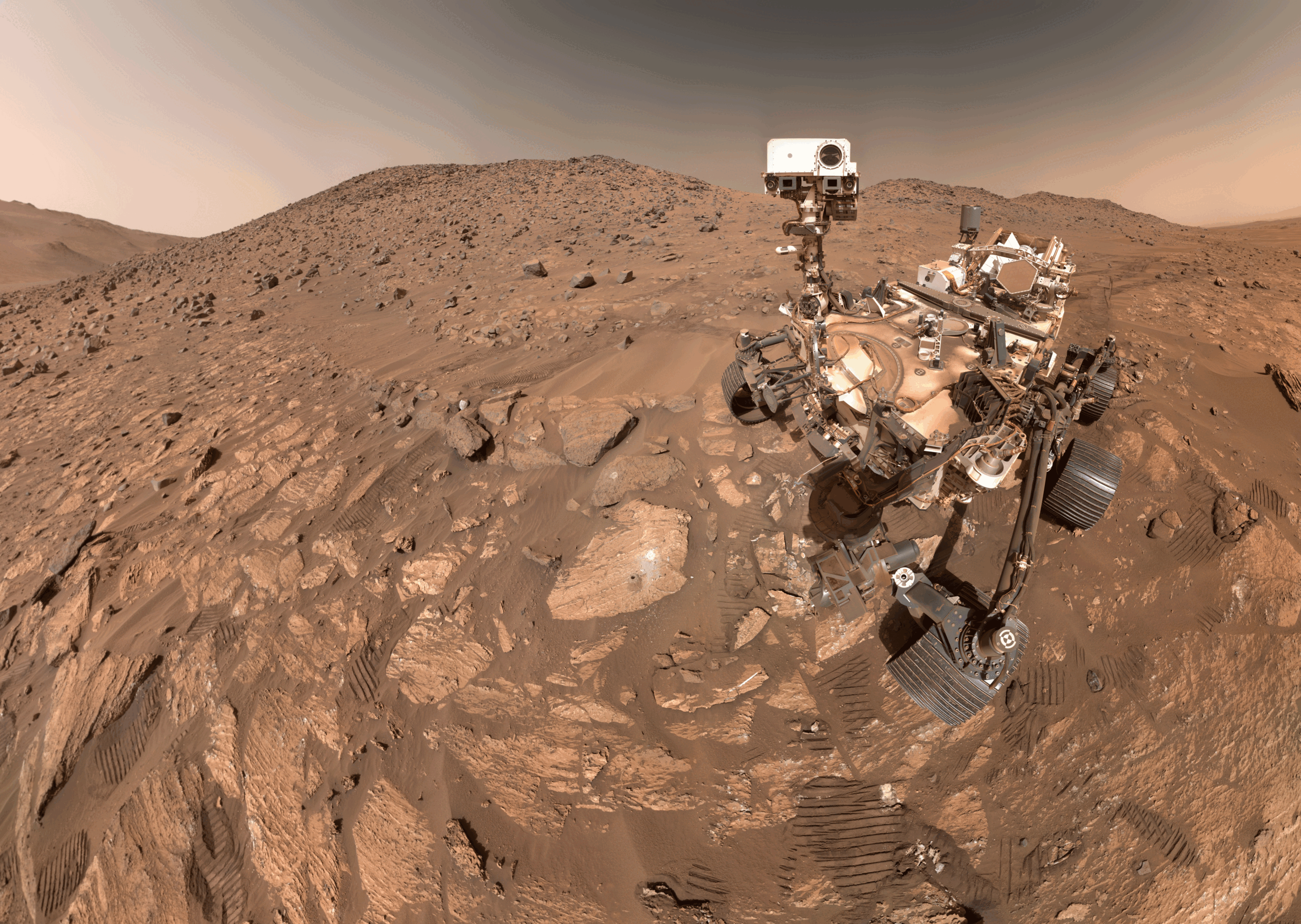
Imagine you’re all alone, driving along in a rocky, unforgiving desert with no roads, no map, no GPS, and no more than one phone call a day for someone to inform you exactly where you are. That’s what NASA’s Perseverance rover has been experiencing since landing on Mars five years ago. Though it carries time-tested tools for determining its general location, the rover has needed operators on Earth to tell it precisely where it is — until now.
A new technology developed at NASA’s Jet Propulsion Laboratory in Southern California enables Perseverance to figure out its whereabouts without calling humans for help. Dubbed Mars Global Localization, the technology features an algorithm that rapidly compares panoramic images from the rover’s navigation cameras with onboard orbital terrain maps.
Running on a powerful processor that Perseverance originally used to communicate with the Ingenuity Mars Helicopter, the algorithm takes about two minutes to pinpoint the rover’s location within some 10 inches (25 centimeters). Mars Global Localization was first used successfully in regular mission operations on Feb. 2, then again Feb. 16.
“This is kind of like giving the rover GPS. Now it can determine its own location on Mars,” said JPL’s Vandi Verma, chief engineer of robotics operations for the mission. “It means the rover will be able to drive for much longer distances autonomously, so we’ll explore more of the planet and get more science. And it could be used by almost any other rover traveling fast and far.”
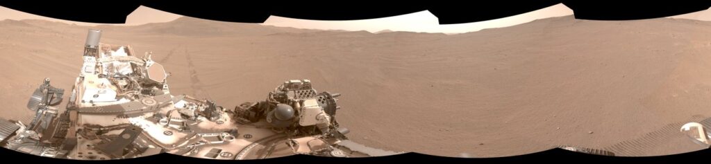
This panorama from Perseverance is composed of five stereo pairs of navigation camera images that the rover matched to orbital imagery in order to pinpoint its position on Feb. 2, 2026, using a technology called Mars Global Localization. (Credit: NASA/JPL-Caltech)
The upgrade is especially valuable given how well Perseverance’s auto-navigation self-driving system has been working. Enabling the rover to re-plan its path around obstacles en route to a preestablished destination, AutoNav has proved so capable that the distance Perseverance can drive without instructions from Earth is largely limited by the rover’s uncertainty about its whereabouts. Now that it can stop and determine its exact location, Perseverance can be commanded to drive to potentially unlimited distances without calling home.
Implementation of Mars Global Localization comes on the heels of another innovation from the Perseverance team: the first use of generative artificial intelligence to help plan a drive route by selecting waypoints for the rover, which are normally chosen by human rover operators. Both technologies enable Perseverance to travel farther and faster while minimizing team workload.
Beyond visual odometry
Unlike on Earth, there is no network of GPS satellites in deep space to locate spacecraft on planetary surfaces. So missions — whether robotic or crewed — must come up with other ways to determine their location.
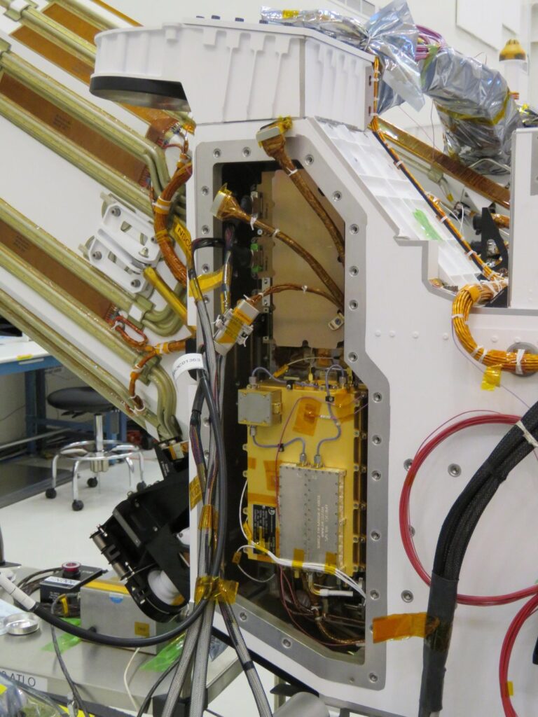
The Mars Global Localization algorithm runs on a fast commercial processor in the Helicopter Base Station — the upper, gold-colored box that was integrated into NASA’s Perseverance rover in a clean room. Perseverance used the base station to communicate with the now-retired Ingenuity Mars Helicopter. (Credit: NASA/JPL-Caltech)
As with NASA’s previous Mars rovers, Perseverance tracks its position using what’s called visual odometry, analyzing geologic features in camera images taken every few feet while accounting for wheel slippage. But as tiny errors in the process add up over the course of each drive, the rover becomes increasingly unsure about its exact location. On long drives, the rover’s sense of its position can be off by more than 100 feet (up to 35 meters). Believing it may be too close to hazardous terrain, Perseverance may prematurely end its drive and wait for instructions from Earth.
“Humans have to tell it, ‘You’re not lost, you’re safe. Keep going,’” Verma said. “We knew if we addressed this problem, the rover could travel much farther every day.”
After each drive comes to a halt, the rover sends a 360-degree panorama to Earth, where mapping experts match the imagery with shots from NASA’s Mars Reconnaissance Orbiter (MRO). The team then sends the rover its location and instructions for its next drive. That process can take a day or more, but with Mars Global Localization, the rover is able to compare the images itself, determine its location, and roll ahead on its preplanned route.
“We’ve given the rover a new ability,” said Jeremy Nash, a JPL robotics engineer who led the team working on the project under Verma. “This has been an open problem in robotics research for decades, and it’s been super exciting to deploy this solution in space for the first time.”
The small team began working in 2023, testing the accuracy of the algorithm they’d developed using data from 264 previous rover stops. The algorithm compared rover panoramic photos to MRO imagery and correctly pinpointed the rover’s location for every single stop.
How Ingenuity helped
Key to Mars Global Localization is the rover’s Helicopter Base Station (HBS), which Perseverance used to communicate with the now-retired Ingenuity Mars Helicopter. Equipped with a commercial processor that powered many consumer smartphones in the mid-2010s, the HBS runs more than 100 times faster than the rover’s two main computers, which, built to survive the radiation-heavy Martian environment, are based on hardware introduced in 1997.
As a technology demonstration designed to test capabilities, the Ingenuity mission was able to risk employing more powerful commercial chips in the HBS and the helicopter even though they hadn’t been proven in space. It paid off: Expected to fly no more than five times, the rotorcraft completed 72 flights.
The power of the HBS processor inspired Verma to look for ways the Perseverance mission might harness it. “It’s almost like a gift. Ingenuity blazed the trail, proving we could use commercial processors on Mars,” Verma said.
Tapping into the HBS computer has had its challenges. To address reliability, the team developed a “sanity check”: The algorithm runs on the HBS multiple times before one of the rover’s main computers checks to ensure the results match. During testing, the team repeatedly found the rover’s position was off by 1 millimeter. They discovered damage to about 25 bits — a minuscule fraction of the processor’s 1 gigabyte of memory — and developed a solution to isolate those bits while the algorithm runs.
Alongside the broader Mars Global Localization process, the team’s sanity check and memory solutions are expected to find new uses as faster commercial processors are employed in future missions. In the meantime, the team has already turned their sights to the Moon, where difficult lighting conditions and long, cold lunar nights make knowing exactly where spacecraft are located all the more critical.
More about Perseverance
NASA’s Jet Propulsion Laboratory, which is managed for the agency by Caltech, built and manages operations of the Perseverance rover on behalf of NASA’s Science Mission Directorate in Washington, as part of NASA’s Mars Exploration Program portfolio. Learn more about Perseverance.
Topcon Positioning Systems and Geophysical Survey Systems, Inc. (GSSI) are collaborating to pair GSSI’s advanced ground penetrating radar systems with Topcon’s GNSS solutions and mass data workflow software. The new integrated solution will support applications across infrastructure and construction projects.
“GSSI is a long-standing industry leader in ground penetrating radar (GPR) systems, and we are excited to work with them on providing industry professionals with an advanced, integrated solution,” said Ron Oberlander, head of the Topcon Geomatics Platform. “By combining GSSI’s GPR technology with Topcon’s HiPer XR GNSS receiver, Topnet Live correction services, and Collage Web mass-data workflow software, we are bridging subsurface detection and spatial context from field to analysis.”
“Collaborating with Topcon allows us to unify GPR data and GNSS data to deliver visual, decision-ready insights, providing a more complete picture of the world above and below the surface,” said Chris Green, chief executive officer of GSSI. “Together, GSSI and Topcon are helping customers plan smarter, validate faster, and deliver higher quality outcomes with fewer surprises.”
The new solution will be showcased in both the Topcon Positioning Systems booth and the GSSI booth at CONEXPO-CON/AGG, taking place March 3-7 in Las Vegas.
In my January 2026 GPS World newsletter, I noted that the National Geodetic Survey (NGS) convened the Federal Geodetic Control Subcommittee (FGCS) meeting with federal geospatial agencies to boost awareness and align efforts on National Spatial Reference System (NSRS) Modernization government-wide. Key steps include cultivating internal champions to champion the initiative, distilling complex topics for clear leadership briefings, and bringing together agencies, partners, and industry to collaboratively shape solutions. I also highlighted that on Feb. 17-18, NGS staff would be participating in Geo Week 2026 in Denver to engage geospatial product and service users and further coordinate on the modernization. NGS gave several presentations during GeoWeek that addressed many of my questions on the new modernized NSRS. This newsletter will highlight some of NGS’s presentations.
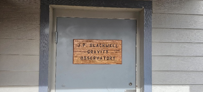
First, a special shout-out to my dear friend and former colleague, Juliana Blackwell, retired Director of the National Geodetic Survey. NOAA’s Table Mountain Gravity Observatory in Boulder, Colorado — long known for its absolute gravity work — has been officially renamed the J. P. Blackwell Gravity Observatory. This well-earned tribute honors her outstanding dedication and visionary leadership at NGS. Congratulations, Juliana!
J. P. Blackwell Gravity Observatory. (Photo: NGS)J. P. Blackwell Gravity Observatory. (Photo: NGS)J. P. Blackwell Gravity Observatory. (Photo: NGS)
NGS employees participated in the following sessions and meetings during GeoWeek 2026:
ASPRS NSRS Modernization Working Group Meeting
NSRS Modernization — The Latest Technical Updates
Preparing to Put the Modernized National Spatial Reference System into Practice
Roundtable — NSRS Modernization and Professional Societies
As President of the American Association for Geodetic Surveying (AAGS), I participated in the session titled “Roundtable – NSRS Modernization and Professional Societies.” Dana J Caccamise II, NGS regional geodetic advisor, opened our session by describing the NGS Modernization Engagement Plan and Progress. As I mentioned last month, Dana should get an award for the material he has prepared and for his work assisting agencies and professional organizations in preparing for the new NSRS. I highlighted Caccamise’s work in my October 2025 GPS World newsletter.
All the NGS sessions provided the latest information on activities associated with NGS’s NSRS Modernization. Here are the specific questions I had going into the session, along with the clear answers provided by NGS personnel during their presentations and the follow-up Q&A:
What NGS products and services will be available when federal agencies officially adopt the new NSRS?
When the modernized NSRS is officially adopted (following FGCS approval and the transition to it becoming “the NSRS”), NGS will make available a full suite of updated tools, data access points, and services built around the new reference frames (e.g., NATRF2022 and variants), the North American-Pacific Geopotential Datum of 2022 (NAPGD2022), the State Plane Coordinate System of 2022 (SPCS2022), and associated geopotential models like GEOID2022. Key products expected to be operational and official include:
NCAT
NGS Maps
Geodetic Station Page
CORS
Geodetic Mark Page
Passive Marks
OPUS–Static 5.2
OPUS-Share
What NGS products and services will NOT be available when federal agencies officially adopt the new NSRS?
Upon official adoption of the modernized NSRS — after FGCS approval and the shift to the new system becoming “the NSRS” — several current products and services will no longer be part of the official modernized NSRS or will be discontinued in their present form. Key items not included or no longer supported in the modernized NSRS release include:
OPUS Projects 5 will not be supported
OPUS-Rapid Static (OPUS-RS) will not be supported (modernized OPUS-Static 5.2 is expected to handle a broader range of observations)
OPUS 6.0 and OPUS 6.1 will not be available
What GNSS data will be included in the first iteration of the computation of Reference Epoch Coordinates (REC) for marks?
At Geo Week 2026, NGS stated that its plans include providing Reference Epoch Coordinates (RECs) for certain legacy GNSS projects. Specifically, this includes:
GPS projects that were originally processed and published under the NAD 83 (2011) realization, and
Other GNSS projects will be officially published by NGS through the end of 2025\
After the first iteration of Reference Epoch Coordinates, is NGS planning to perform future adjustments to determine REC and SEC of new marks? If so, what process will be used to establish RECs on new marks?
Yes, NGS plans include performing future adjustments to compute Reference Epoch Coordinates (REC) for new marks. However, at this time, no final decision has been made on how often this will be performed.
Has NGS changed how users need to submit data to incorporate leveling data into NAPDG2022?
Yes, NGS has introduced changes to better integrate leveling data (differential height differences) into the modernized NSRS for computing orthometric Reference Epoch Coordinates (RECs) in NAPGD2022 (epoch 2020.00).
As documented in Blueprint Document 3, when performing leveling projects, users will also be required to occupy a number of primary marks with GNSS.
OPUS 6.1 is built for future expansion to support other geodetic measurements (classical, leveling)-no timeframe was given for this.
Is NGS planning to officially adopt the new NSRS before users can submit data to NGS for technical review and publication in the NGS database?
Yes, that is what NGS is saying at this moment (February 2026). OPUS Project 5 will not be supported and OPUS 6.1 will not be operational when the new NSRS is officially adopted.NGS is working on the OPUS 6 application and is trying to “minimize any gap in service.”
Is NGS recommending using the OPUS-Share utility until users can submit data to NGS for technical review and publication in NGS database?
Yes, that is what NGS is recommending at this moment (February 2026).
OPUS-Projects 5 will not be included in the modernized NSRS. Instead, NGS will focus on both developing an improved software suite for OPUS, known as OPUS 6.0 and OPUS 6.1, and minimizing any gap in service in which the current OPUS-Projects functionality is not available for users to organize, process, adjust, and submit high-accuracy GPS surveys for use by NGS in expanding and improving the NSRS. As noted above, OPUS-Share will remain available as a means to submit data to NGS.
When will OPUS 6.1 be available for users to submit data to NGS for technical review and publication in NGS database? Is it weeks away, months away, or years away?
NGS has not announced an official completion or release date for OPUS 6.0 and OPUS 6.1. However, they have indicated that active development is underway on this enhanced OPUS tool suite. It’s not imminent— meaning not expected within several months—but it’s also not a distant, multi-year project.
NGS is working on the application and is trying to “minimize any gap in service.”
“OPUS-Projects 5 will not be included in the modernized NSRS. Instead, NGS will focus on both developing an improved software suite for OPUS, known as OPUS 6, and minimizing any gap in service in which the current OPUS-Projects functionality is not available for users to organize, process, adjust, and submit high-accuracy GPS surveys for use by NGS in expanding and improving the NSRS. As noted above, OPUS-Share will remain available as a means to submit data to NGS.”
What’s the cut-off date for users to submit projects via OPUS Project 5 so the data can be part of future computations of RECs?
Current OPUS-Projects 5 is going to be supported until adoption of the new NSRS, with a deadline announced at least 6 months in advance.
“Note: the current OPUS Projects 5 software will be supported until the modernized system is adopted, and a deadline for OPUS-Projects users to submit their surveys for publication will be announced with at least six months’ notice.”
In the session “NSRS Modernization – The Latest Technical Updates,” the National Geodetic Survey (NGS) presented slides detailing the status and upcoming tasks for the modernized National Spatial Reference System (NSRS). Key highlights from the presentation are summarized below.
106th Wyoming Engineering and Surveying (WES) Society Conference – February 5, 2026 – Brian Shaw
2026 GeoWeek – Modernized Tools – February 17, 2026 – Brian Shaw
2026 GeoWeek – Updates to OPUS for Accessing the Modernized NSRS – February 17, 2026 – Dan Gillins
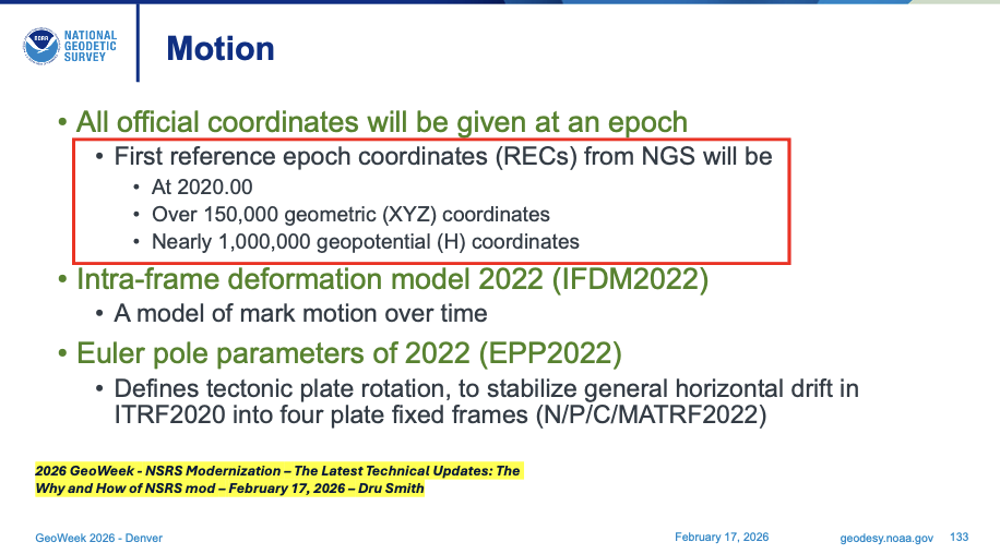
During Dru Smith’s presentation, he mentioned what will be included in the first iteration of the computation of Reference Epoch Coordinates (REC) for marks. The slide states that more than 150,000 geometric (XYZ) coordinates and 1 million geopotential coordinates (that is, orthometric heights) will get reference epoch coordinates (REC), epoch 2020.00. These will include data from NGS Integrated Database and from the OPUS Share database.
First Reference Epoch Coordinates (REC). (Presented at GeoWeek 2026)First Reference Epoch Coordinates (REC). (Presented at 106th WES Society Conference)
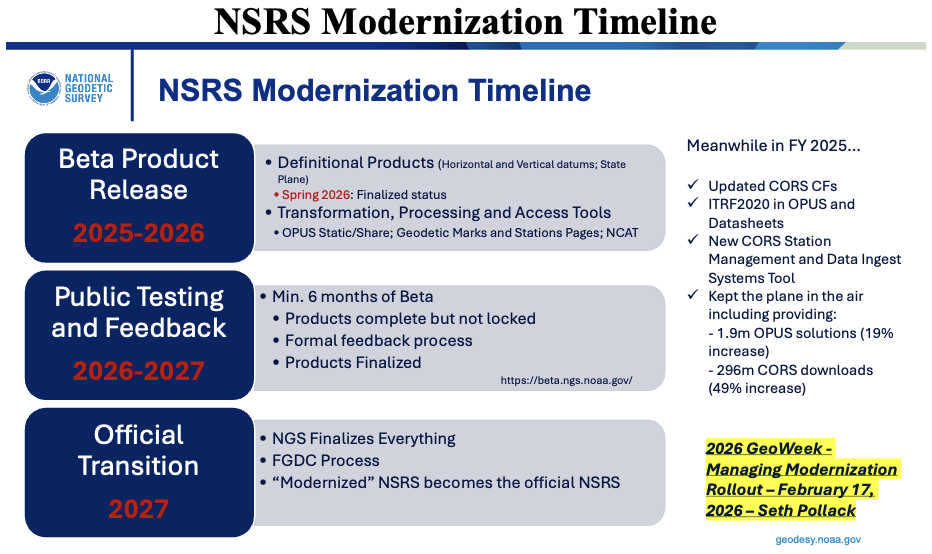
In the GeoWeek 2026 presentation by Seth Pollack (from NOAA’s National Geodetic Survey), a slide outlined the NSRS modernization timeline.
As detailed in the slide and consistent with NGS’s official rollout plan:
Beta products are currently being released incrementally on the beta site for public testing and feedback. This phased rollout began with initial beta releases in 2025 (following alpha in 2024) and continues through 2026, covering key components such as NAPGD2022, GEOID2022, SPCS2022, enhanced NCAT transformation tools, OPUS-Static updates, and forthcoming Data Delivery System features.
Each beta component, once released, undergoes public testing and stakeholder feedback, with overall testing continuing for at least 6 months after the final component is made available on the beta site.
Following sufficient testing—once all components appear stable and NGS has incorporated feedback—the Federal Geodetic Control Subcommittee (FGCS) will vote to recommend approval of the modernized NSRS. This vote is anticipated in late 2026 or early 2027.
Upon FGCS approval (and subsequent Federal Geographic Data Committee (FGDC) endorsement), NGS will probably publish a Federal Register Notice announcing the adoption. At that point, the modernized NSRS becomes the official National Spatial Reference System, replacing the legacy system (NAD 83 realizations, NAVD 88, etc.).
While earlier NGS documentation targeted adoption likely in mid-to-late 2026 (post-FGCS vote), recent updates from GeoWeek 2026 sessions and related reports indicate the full official adoption and transition may extend into the first part of 2027, accounting for final testing, FGCS/FGDC processes, Federal Register steps, and a smooth handover to avoid disruptions.
The current NSRS remains official throughout this period. Users are encouraged to test beta products now and provide feedback to help refine the system.
NSRS Modernization Timeline. (Presented at GeoWeek 2026)
Brian Shaw, NGS’s expert on GIS products and services, presented key updates on how users will access geodetic data in the modernized National Spatial Reference System (NSRS).
He emphasized the introduction of a revamped Data Delivery System (DDS), which includes:
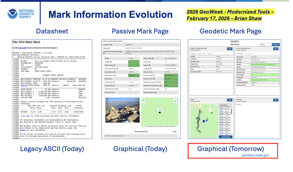
Geodetic Mark Pages — for passive marks. These replace the current ASCII-text datasheets with modernized, user-friendly pages featuring updated Reference Epoch Coordinates (RECs), integrated photos, graphics, maps, project details, and easier navigation.
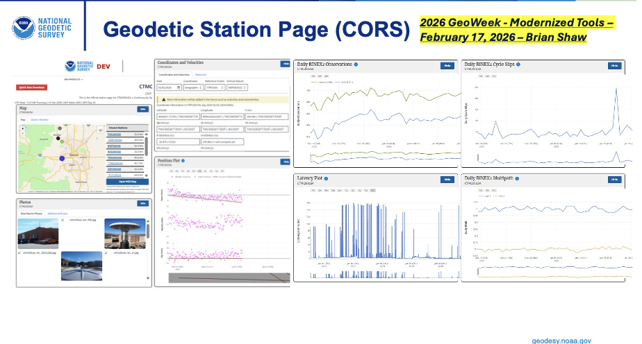
Geodetic Station Pages — for active stations like those in the NOAA CORS Network (NCN). These provide updated versions of existing CORS pages, including modernized coordinate functions (e.g., Coordinate Functions or time-dependent positioning info) aligned with the new reference frames (NATRF2022, etc.).
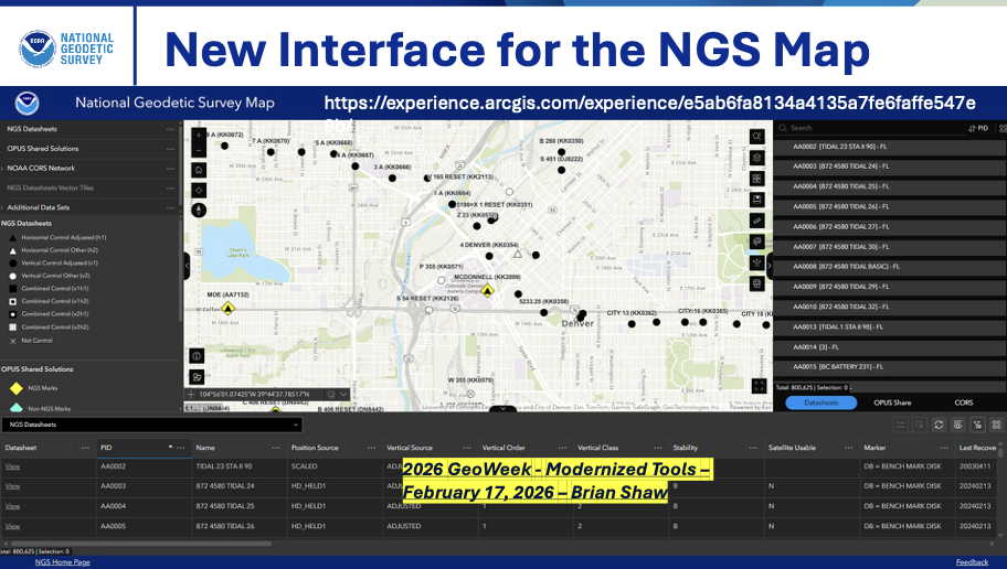
Additionally, Shaw highlighted a new interface for the NGS Map (the interactive web map application), serving as an enhanced landing page within the DDS. This updated “NGS Map” (replacing or evolving the current version at https://noaa.maps.arcgis.com/apps/webappviewer/index.html?id=190385f9aadb4cf1b0dd8759893032db ) will provide better access to geodetic control data, CORS stations, and other layers, improving visualization and querying for surveyors, GIS professionals, and the public.
These changes are part of the broader DDS rollout, currently pending beta release (as of February 2026), aimed at making data more accessible, visually rich, and compatible with the modernized NSRS components (e.g., NATRF2022, NAPGD2022, SPCS2022). The DDS landing page will consolidate access, moving away from legacy datasheet formats toward dynamic, web-based delivery.
Accessing Data from NGS. (Presented at GeoWeek 2026)Accessing Data from NGS. (Presented at GeoWeek 2026)Accessing Data from NGS. (Presented at GeoWeek 2026)
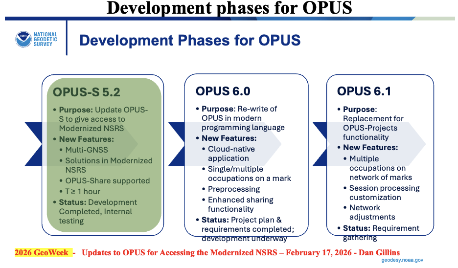
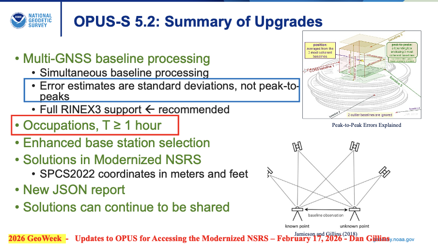
During Dan Gillins presentation he highlighted that NGS has three development phases for OPUS underway to support the Modernized NSRS:
OPUS-S 5.2:Multi-GNSS with similar functionality as current OPUS-S
Occupations – one hour or greater
Standard deviations estimate instead of peak-to-peak values
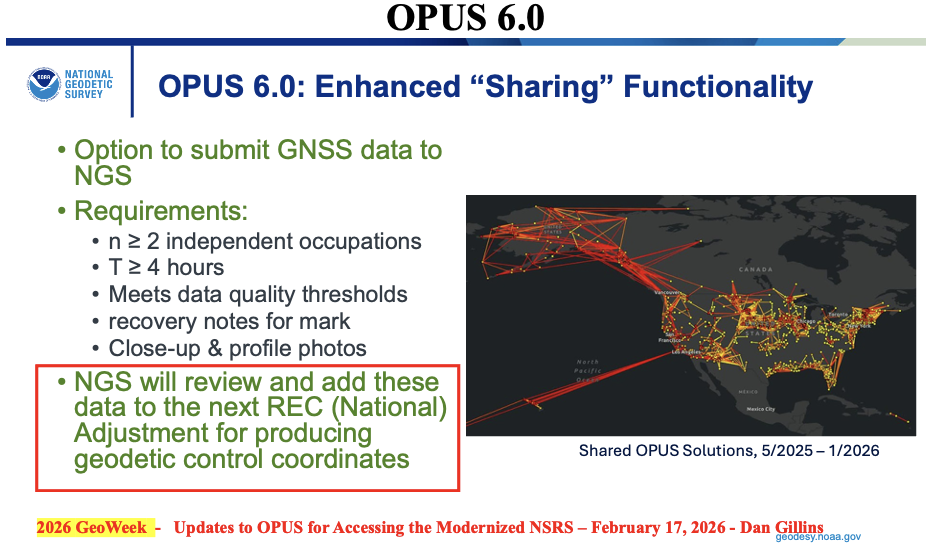
OPUS 6.0:Rewrite of code base in cloud-native application
single/multiple occupations on a single mark
enhanced sharing functionality
Occupation Time – minimum of 4 hours
NGS will review and add these data to the next reference epoch coordinate (REC) adjustment
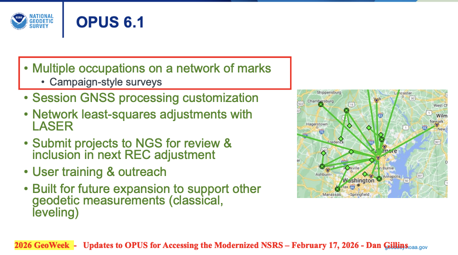
OPUS 6.1: Extension of OPUS 6.0 for multiple marks in a network
Replace OPUS-Projects functionality
Multiple occupations on a network of marks (campaign-style surveys)
Will allow multiple occupations on a single mark – uploads ~10 data files on a mark
Built for future expansion to support other geodetic measurements (classical, leveling)
I want to emphasize that, in my opinion, NGS is doing a fantastic job with the limited resources that they have. That said, I still have an issue with adopting the new NSRS without having a process for users to submit data to NGS for review, approval, and publication by NGS. This may not be an issue if NGS’s OPUS 6.1 is available soon after the new NSRS is adopted by the Federal Agencies.
My August 2025 GPS World Newsletter discussed the OPUS products under development and, as I mentioned at that time, in my opinion, may be a problem for some users. As I stated in my August newsletter, for the new NSRS to be successfully implemented by users, it is essential that all the necessary software tools are available to enable users to submit projects for review, approval and publication by NGS.
“The NGS News announcement provides a list of products that will be available and a list of products that will not be available when the new NSRS is adopted. Users need to understand what products will not be available after NGS officially adopts the new NSRS so they can determine what that means to their workflow process and client requirements. In my opinion, for the new NSRS to be successfully implemented by users, it is essential that all the necessary software tools are available to enable users to submit projects for review, approval, and publication by NGS. As many of you know, when I worked for NGS, I was the Project Manager of the North American Vertical Datum of 1988 (NAVD 88). That said, from my experience as the NAVD 88 Project Manager, having the appropriate tools available was important for users to implement NAVD 88. As a matter of fact, NGS accepted and processed vertical control data in both NGVD 29 and NAVD 88 for a period to assist users in the implementation of the new vertical reference datum.”
NGS does state that users will be able to submit data through OPUS and OPUS Share to obtain estimates of coordinates in the new NSRS. Unfortunately, using OPUS-Share results that are NOT official NSRS coordinates published by NGS could lead to confusing results and potential lawsuits since NGS does not stand behind the results and recommends NOT using OPUS-Share results for geodetic control.
“This is NGS’s statement on OPUS-Share: Additionally, the popular function of “sharing” your solution with others (colloquially called “OPUS-Share”) will be retained, but with appropriate caveats that the shared solution should not be used as geodetic control. These shared solutions will be available through the geodetic mark pages of the DDS.“
Why should users use OPUS-Share to establish geodetic control when NGS advises against relying on OPUS-Share for establishing geodetic control? OPUS-Share results are not officially submitted to NGS for review, approval, and publication on an NGS Datasheet. I don’t believe this approach will meet the needs of users who require their projects to be reviewed, approved, and published by NGS.
Finally, as someone deeply invested in the geodetic community—having retired from NGS and followed NGS developments closely for years—my overall opinion on the NSRS modernization rollout plan for the remaining products is cautiously positive, but with some genuine concerns that I believe NGS and stakeholders should address head-on to ensure a smoother transition.
The phased beta release approach (starting in 2025 and continuing through 2026) is smart and user focused. Releasing components incrementally on the beta site, allowing at least 6 months of public testing and feedback per major piece (and overall testing extending beyond the final release), shows NGS is prioritizing stability over speed. The emphasis on stakeholder input, FGCS approval (now looking like late 2026 or early 2027), and a multi-month transition to the official site align well with best practices for such a massive shift. It’s encouraging to see private industry partners (e.g., ESRI, Blue Marble) already engaging deeply and planning implementations—success will depend on industry buy-in.
That said, here are my main thoughts and concerns I’d share directly with NGS (perhaps via [email protected], user forums, or upcoming webinars/Q&A sessions):
Timeline uncertainty: Clearer, more frequent milestone updates (beyond the Track Our Progress page) would help manage expectations. For example, monthly or bimonthly “status dashboard” with remaining beta items and projected release windows would be invaluable.
OPUS and processing continuity: The shift away from OPUS-Projects 5 toward OPUS 6 and OPUS-Share is logical for a modern GNSS-centric system, but the lack of a firm end-of-support date for legacy OPUS tools (beyond “at least 6 months’ notice”) creates planning headaches for firms with ongoing projects. NGS should commit to a longer grace period—or ideally a defined parallel support window—for legacy OPUS tools (particularly OPUS-Projects 5) after the official adoption of the modernized NSRS.
Data access and usability in the new DDS: The revamped Geodetic Mark/Station Pages, updated NGS Map interface, and overall Data Delivery System sound promising (more visual, integrated RECs/SECs, photos, etc.), but surveyors rely heavily on reliable, scriptable access (e.g., for bulk queries or automation). If the new web-based system lacks robust APIs or export options comparable to current datasheets/legacy tools, it could hinder efficiency. Beta testers should push hard on this during the 6+ month window.
Transformation tools and legacy data handling: Enhanced web-based tools are key for bridging old-to-new (NAD 83/NAVD 88 to NATRF2022/NAPGD2022), but users need confidence that transformations minimize errors, especially in deformation-prone areas.
Communication and outreach: NGS has improved with webinars, the Presentations Library, and beta feedback channels, and more targeted outreach to state agencies, professional societies (NSPS, AAGS), and software vendors has helped. That said, many in the field still feel “in the dark” about practical impacts—case studies, training resources, and FAQs tailored to common workflows would go far.
In summary, the plan is thoughtful and deliberate, reflecting lessons from past delays. If NGS maintains transparency, incorporates feedback aggressively during beta, and ensures vendor readiness, the modernized NSRS will be a major win for accuracy, sustainability, and GNSS alignment.
I’d encourage anyone reading this (including NGS staff) to test the beta products actively, submit detailed feedback, and participate in forums/Q&As. The community input will make or break the success of this once-in-a-generation update.
Wear Elite is a personal AI platform designed to unlock the next generation of truly personal, always-on, intelligent wearable computing devices. It works acrossWearOS by Google, Android and Linux with a neural processing unit (NPU) for on-device AI and advanced suite of ultra-low power connectivity solutions.
The Snapdragon Wear platform introduces a multi‑mode connectivity architecture integrating six advanced technologies: GNSS, 5G RedCap, Micro‑Power Wi‑Fi, Bluetooth 6.0, UWB and NB‑NTN. The company’s GNSS solution enables advanced processing for precise location context that helps AI better understand where users are and adapt interactions accordingly.
Snapdragon Wear Elite delivers key on‑device capabilities that support rich, real‑time agentic experiences. By integrating the Qualcomm Hexagon NPU to support up to billion‑parameter models at the edge, and pairing it with advanced sensor fusion, high-performance, low-power connectivity and computing, Snapdragon Wear Elite enables a new class of Personal AI experiences, including context‑aware recommendations, natural voice interactions, life logging and AI agents that can take actions and orchestrate tasks on users’ behalf.
Snapdragon Wear Elite delivers a massive leap in power efficiency backed by 5x improvement on single-core CPU performance and up to 7x faster GPU, for app launching, multitasking and smoother rendering.
The platform supports multi-day battery life, reducing charging sessions, while advanced power management enables 30% longer day of use compared to the previous generation. When recharging is needed, rapid charging powers a device up to 50% in approximately 10 minutes.
Collaboration focused on enabling plug-and-play, GPS-denied navigation capabilities for next-generation maritime platforms
Anello Photonics and Mythos AI are accelerating deployment of resilient, plug-and-play navigation solutions for the maritime sector. The collaboration brings together Anello’s advanced inertial sensing technology and Mythos AI’s intelligent autonomy software to address the growing need for resilient navigation in GPS-challenged environments.
Anello is creator of the Silicon Photonics Optical Gyroscope (SiPhOG). By combining SiPhOG-based inertial navigation with advanced sensor fusion and AI-driven collaborative autonomy, Anello and Mythos AI are delivering a fully integrated, plug-and-play solution that maintains performance when satellite signals are degraded or unavailable. It is designed to drop seamlessly into both next-generation and legacy maritime platforms. A multi-mission open systems architecture enables scalable deployment across defense, commercial and hybrid maritime operations.
Strategic focus on maritime autonomy and USVs
The initiative is particularly relevant to the rapidly evolving unmanned surface vehicle (USV) market. As USVs take on expanded roles in offshore energy, maritime security, hydrography, environmental monitoring and defense missions, complete end-to-end dependable navigation is essential to safe and effective operations.
A resilient, GPS-independent navigation capability enables:
greater operational assurance in GPS-denied or contested maritime environments
enhanced autonomy and mission continuity during signal disruptions
reduced integration complexity for OEMs and system integrators
scalability across a broad range of vessel sizes and mission profiles.
Anello and Mythos AI will collaborate with OEMs, integrators and end users to align the solution with evolving operational and regulatory demands.
Oscilloquartz has entered a joint technology validation with Tupaia, demonstrating how mobile operators and enterprises can achieve high-accuracy GPS positioning using existing timing infrastructure.
The validation, conducted through a real-world drive test across mixed highway and semi-urban environments, confirms that Oscilloquartz grandmasters can integrate with Tupaia’s cloud services to enable advanced positioning without dedicated, standalone reference-station networks — reducing deployment complexity and cost.
“This collaboration shows what’s possible when precise timing infrastructure is combined with cloud-based positioning intelligence,” said Nadav Lavi, CEO of Tupaia. “By integrating Tupaia’s cloud service with Oscilloquartz’s installed base, mobile operators can immediately offer centimeter-level positioning to commercial users across applications such as the Internet of Things, drones, automotive and logistics.”
During the validation, positioning results from a single GPS device were compared against calculations made by Tupaia’s cloud service using Oscilloquartz grandmasters. Tupaia’s cloud-based navigation consistently reduced typical multi-meter GPS errors to centimeter-level accuracy throughout the drive.
The test also demonstrated a flexible deployment model in which Oscilloquartz grandmasters can function as both reference stations and rovers, allowing high-precision positioning services to be layered onto existing timing networks without additional infrastructure.
“Mobile operators are increasingly looking to extract more value from infrastructure they already trust and operate,” said Gil Biran, general manager of Oscilloquartz. “This validation shows how our grandmaster platforms can be extended beyond synchronization to support advanced positioning use cases, enabling new revenue-generating services while preserving existing network architectures.”
Biran added that building on deployed timing assets allows operators to accelerate the rollout of high-precision positioning while avoiding the cost of installing new antennas or dedicated positioning equipment.
CGI, one of the largest independent IT and business consulting services firms in the world, has entered an alliance partnership agreement with Vantor, provider of unified spatial intelligence from space to ground. The companies have signed a Letter of Intent outlining their plans to collaborate on developing next-generation solutions that combine CGI’s advanced artificial intelligence (AI), edge computing and visual analytics expertise with Vantor’s Spatial Intelligence platform Tensorglobe and its Raptor product for navigation and geolocation in GNSS-denied environments.
The collaboration will enhance mission effectiveness and real-time situational awareness across defense, national security and environmental domains. CGI and Vantor will deliver integrated intelligence solutions that combine AI, spatial intelligence, space-based sensing and digital platforms, enabling faster, more informed decision-making in increasingly complex operational environments.
The partnership reflects growing demand for interoperable, sovereign and commercial solutions that strengthen operational resilience in a changing geopolitical and environmental landscape.
“We are bringing together complementary strengths in AI-driven analytics and secure, scalable access to satellite data through this collaboration with Vantor. As governments and industry organisations look to improve resilience and responsiveness, integrating near-real-time space-based intelligence into digital command and control networks will be key to achieving decision advantage,” said John Hanley, Secure Mission Critical Solutions, CGI.
“Collaborating with CGI allows us to extend the reach of Vantor’s technology and apply it to new use cases that demand both agility and precision. Our combined capabilities will help defense and civil government customers derive actionable intelligence faster and more securely, supporting safer operations and smarter use of global data assets,” said Anders Linder, general manager, Vantor International.
The companies seek to develop solutions that fuse CGI Machine Vision and CGI SignalSense platforms with Vantor’s Tensorglobe services to enhance high-precision geo-positioning and imagery analytics. Integration with Vantor’s Raptor products will support users operating in GNSS denied or degraded environments to navigate and position coordinates. The collaboration will pursue opportunities across the UK, Europe, and allied markets for AI-enabled edge computing and space-based situational awareness capabilities.