Advanced Navigation has raised $110 million in a Series C funding round aimed at expanding its positioning, navigation and timing (PNT) technology portfolio.
Airtree Ventures led the round, with participation from Quadrant Private Equity and the National Reconstruction Fund Corporation (NRFC). Existing investors — including Main Sequence, KKR, In-Q-Tel, Alpha Intelligence Capital, Malcolm Turnbull and OIF Ventures — also participated.
The Sydney-based company develops alternative positioning, navigation and timing, or PNT, systems designed to function when GPS signals are degraded or unavailable. Its products are used across defense, energy, maritime and space applications.
Chris Shaw, CEO and co-founder of Advanced Navigation
Chris Shaw, chief executive and co-founder, said demand for GPS-independent navigation has grown as threats such as signal jamming, spoofing and infrastructure-denied environments have become more common.
“As autonomous vehicles scale into contested and high-stakes frontiers, the world’s reliance on any single navigation technology has evolved from a technical limitation into a systemic vulnerability,” Shaw said.
The company’s customers include Anduril, the National Oceanic and Atmospheric Administration, Hanwha, BHP, Rheinmetall and Intuitive Machines. Advanced Navigation reported triple-digit revenue growth over the past year, with more than 80% of revenue generated in the United States and Europe.
The company said it plans to use the funds to establish what it calls PNT Centers of Excellence in the U.S. and European markets, embedding engineering teams in key regions to support local operations and supply chains. The investment will also support technology acquisitions in robotics, photonics, computer vision, artificial intelligence and quantum sensing.
At the center of Advanced Navigation’s product architecture is a software fusion engine called AdNav Intelligence, which combines data from multiple sensors in real time to maintain navigation accuracy when GPS is unavailable.
The company has deployed more than 100,000 systems across multiple countries.
Modernized GPS is strengthening operational assurance and signaling a new era of assured positioning, navigation and timing (PNT) for U.S. and allied forces
L3 Harris has reached a milestone with the delivery of the 100,000th next-generation military-code (M-code) GPS receiver to the United States and allied partners through the Modernized GPS User Equipment (MGUE) Increment 1 program.
M-code receivers are designed to deliver secure, jam-resistant PNT capabilities that are essential as military operations grow more distributed, joint and technologically complex. Unlike legacy systems, M-code-enabled receivers provide enhanced security features and increased resistance to interference, allowing forces to maintain trusted GPS access when signals may otherwise be degraded or denied.
“As the global threat environment continues to evolve, secure and resilient PNT has never been more critical to ensuring operational advantage,” said Quinlan Lyte, president, Advanced Effects, Missile Solutions, L3Harris. “Reaching this delivery milestone reflects our team’s sustained commitment to equipping the warfighter with reliable technology designed to perform in the most contested environments.”
Beyond the milestone itself, the scale of fielded MGUE Increment 1 receivers underscores a broader shift toward modernized, mission-ready GPS capability across U.S. and allied platforms. From air and ground systems to maritime and joint operations, M-code technology is helping commanders operate with greater confidence in environments where GPS reliability can no longer be assumed.
Onto the next phase
L3Harris is building on the momentum from MGUE Increment 1 as the company advances the next phase of GPS modernization through MGUE Increment 2. Ongoing development includes a new M-code-enabled application-specific integrated circuit and the TruTrak-M Type II receiver, technologies designed to further improve size, weight, power and cost efficiencies while maintaining robust security and performance. These advancements will enable greater integration and flexibility, as well as broader adoption across future platforms.
GNSS receivers combined with inertial navigation systems (INS) have been widely applied to various mobile platforms.
However, in Arctic regions, GNSS positioning accuracy is severely degraded from low satellite elevation angles, frequent ionospheric disturbances, and insufficient visible satellites.
Moreover, the limited validation of existing onboard navigation systems further exacerbates the challenges of Arctic navigation.
To address these issues, a new research paper describes a hybrid neural network model based on temporal convolutional networks (TCN) and long short-term memory (LSTM) networks. The hybrid solution has been tested in the Artic with successful results.
The paper, “Robust GNSS/INS Integrated Navigation in Arctic GNSS-Challenged Environments Based on TCN-LSTM and MDAREKF,” is authored by Wei Liu, Tengfei Qi, Yuan Hu, Kaiwei Zhu, Tsung-Hsuan Hsieh and Shengzheng Wang of Shanghai Maritime University (DOI 10.1088/1361-6501/ae5279).
The proposal combines the pseudo-measurement information of GNSS predicted by the model with INS for integrated navigation to compensate for the interruption of GNSS and correct the error of INS.
Considering the potential bias in predicted pseudomeasurements, an adaptive robust extended Kalman filter (AREKF) algorithm based on Mahalanobis distance is further developed to dynamically adjust the innovation covariance matrix, thereby enhancing filter robustness.
Field experiments conducted on an Arctic survey vessel demonstrate that the proposed TCN-LSTM combined with AREKF significantly improves both the robustness and accuracy of integrated navigation under GNSS-constrained environments. In particular, during GNSS outages of 50 seconds, 140 seconds and 400 seconds, the proposed method reduces the horizontal root mean square error (RMSE) by 47%, 38% and 76% respectively.
Ultra-low-noise amplifiers developed by European Engineering Consultancy Ltd. (EECL) are operating in orbit on the European Space Agency’s (ESA’s) HydroGNSS mission, marking a technical milestone for the hardware following the satellites’ launch in November 2025.
HydroGNSS consists of two small satellites designed to measure hydrological and climate-related variables using GNSS reflectometry. The satellites collect signals transmitted by navigation satellites such as GPS and Galileo and analyze those signals after they reflect from Earth’s surface. The reflected signals provide data on environmental parameters including soil moisture, freeze–thaw conditions in permafrost regions, wetlands and inundation, and above-ground biomass.
The satellites were launched aboard a SpaceX Falcon 9 rideshare mission from Vandenberg Space Force Base in California on Nov. 28, 2025. The mission is part of the European Space Agency’s Scout program, which focuses on relatively small and cost-effective Earth observation satellites designed to demonstrate new measurement techniques.
EECL designed and manufactured six multiband ultra-low-noise microwave amplifiers used in the spacecraft payload. The amplifiers are part of the radio-frequency front end of the receiver system and are designed to amplify very weak reflected GNSS signals while minimizing additional noise, helping preserve signal quality for scientific analysis.
Early on-orbit results indicate the satellites’ payloads are functioning as expected. Both spacecraft have begun collecting delay-Doppler maps of reflected GNSS signals, an early step in commissioning that confirms the receivers are acquiring and processing signals properly.
The HydroGNSS satellites were built by Surrey Satellite Technology Ltd., which also developed the GNSS receiver used on the mission. The spacecraft operate in low Earth orbit and are phased apart to increase global coverage of the measurements.
Data from HydroGNSS are expected to support research on the global water cycle and contribute to studies related to climate monitoring, agriculture, flood risk and ecosystem changes.
Hemisphere GNSS, a brand of CNH, together with Calian Group Ltd, have released the A65 GNSS antenna, a jointly developed, next-generation solution engineered to deliver exceptional accuracy, superior interference protection, and robust GNSS tracking performance.
The A65 is designed as a drop-in replacement for the widely deployed A45 antenna, offering users a seamless upgrade path to the latest precision technology.
The collaboration reflects a shared focus on combining advanced RF design with real‑world application insight to address increasingly complex GNSS operating environments, with both teams working closely from the earliest stages of development to meet demanding original equipment manufacturer (OEM) performance requirements.
The antenna architecture itself, including the stacked patch quad feed element and RF front end, was engineered by Calian, and provides Calian’s XF Filtering. Hemisphere GNSS contributed application expertise, system integration requirements, and performance validation within real-world machine control, agriculture, marine and survey environments.
The result is a precision antenna that delivers:
outstanding multipath suppression
highly consistent phase center variation
accurate tracking across GPS (L1/L2/L5), Galileo (E1/E5/E6), BeiDou (B1/B2/B3), GLONASS (G1/G2/G3), NavIC L5, QZSS, and L-band correction services
lower power consumption and broad voltage compatibility
Together, Hemisphere and Calian ensured the A65 meets demanding field requirements while exceeding the performance benchmarks of the A45.
Calian XF Filtering for Interference Rejection
A major advancement of the A65 is the integration of Calian’s XF Filtering. The interference mitigation system rejects out-of-band energy at the antenna level, significantly improving signal quality in RF-challenging environments.
Calian XF Filtering provides protection against:
4G / 5G cellular transmissions
Ligado and adjacent band interference sources
broadband marine and aviation systems
industrial and urban RF noise
By combining Calian’s advanced filtering technology with Hemisphere GNSS’s application-level expertise, the A65 delivers cleaner signals, improved reliability, and more stable performance in harsh real-world environments.
Engineered for rugged field use
Validated through Hemisphere GNSS field testing and Calian engineering qualification, the A65 includes:
IP69K environmental protection
High-impact LEXAN radome and robust metallic base
Low noise amplifier (LNA) with high gain (2.5 dB NF, 28-30 dB gain)
15 kV electrostatic discharge (ESD) protection
-40°C to +85°C operating range
These specifications are designed to ensure the A65 provides long-term performance across agriculture, survey, machine control, marine and fixed-reference installations.
The A65 GNSS antenna is available now through Hemisphere GNSS. OEM module versions based on the same Calian engineered design are also offered for integrators requiring embedded solutions.
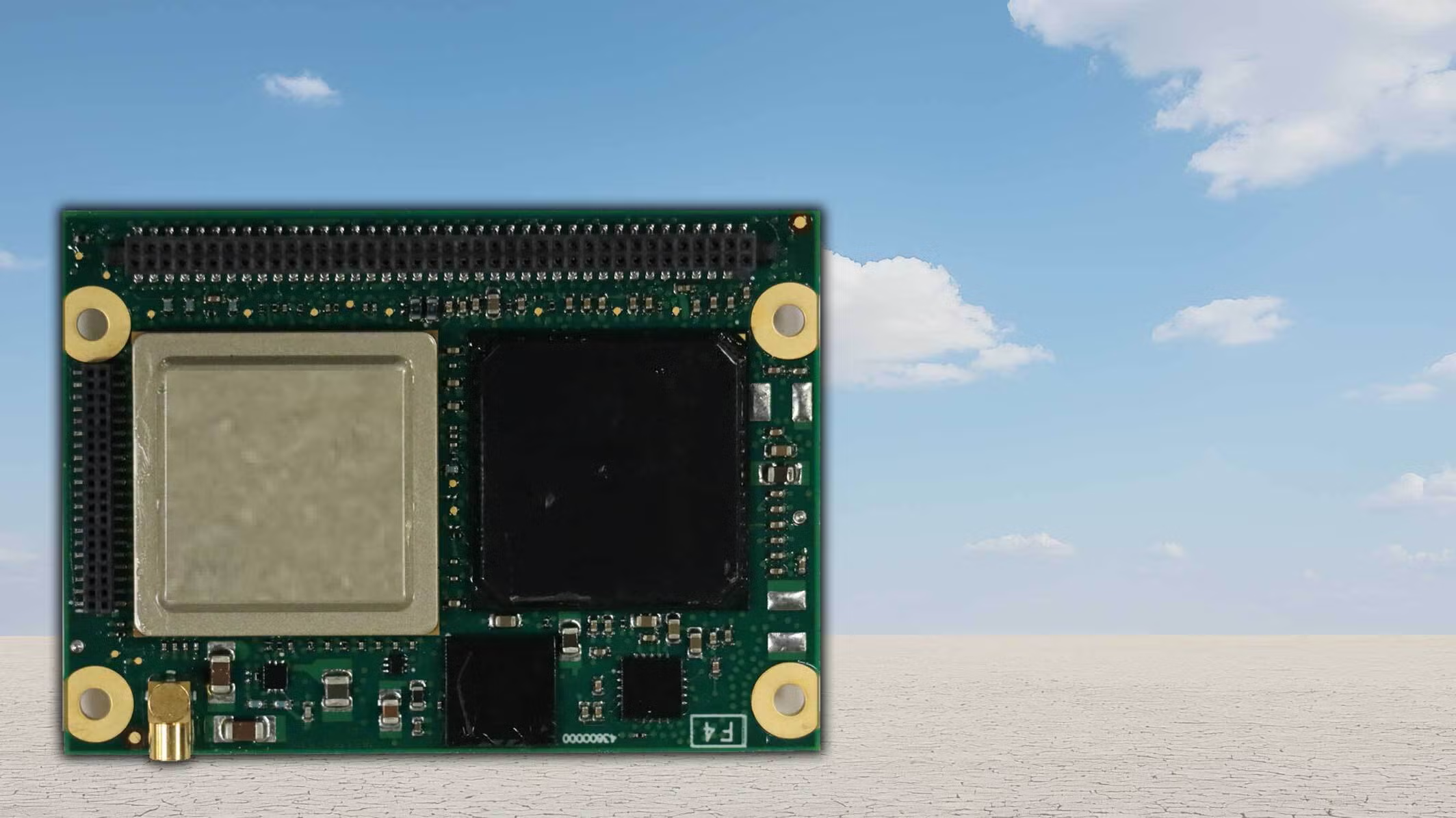
The small-form-factor Galileo OS (Open Service) or PRS (Public Regulated Service) sensors are designed to enhanced GNSS receivers and resilient multi-sensor navigation systems, ensuring safer and more reliable satellite-based navigation.
The Galileo PRS core module integrates a certified, single-chip, application-specific integrated circuit (ASIC) security module that incorporates all the necessary Galileo PRS security and navigation functions. It provides dual-frequency (E1/E6) iono-free Galileo PRS positioning, velocity and timing services. It also provides pseudorange and delta pseudorange raw data, along with GPS C/A (coarse acquisition).
The low-SWaP (size, weight and power) digital solution has been designed to work with any European GNSS receiver manufacturer seeking a standardized, easy-to-integrate Galileo module with which to develop their own GNSS receivers.
Credit: Thales
The modules can meet the requirements of a wide range of applications for manned or unmanned vehicles, combat aircraft, helicopters, high-dynamic missiles, and the navy. Their small form factor also makes them suitable for platforms with size constraints, such as ground vehicles, small drones and guided munitions.
The modules feature standardized interfaces, enabling the Galileo PRS function to be easily integrated into the host system. Furthermore, the TopStar Galileo core module can be embedded with minimum impact by using the analog RF front end of the host receiver.
The Galileo OS core module version enables the early integration of Galileo functionalities into the host system, as well as export to countries not authorized to use PRS. The PRS core module version provides an easy upgrade to Public Regulated Service capability, offering greater resilience against jamming and crucial protection against spoofing.
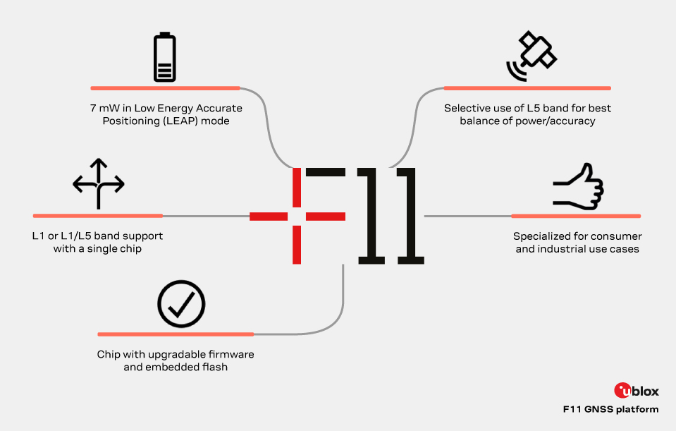
The new u-blox F11 platform provides L1/L5 dual-band standard-precision GNSS designed to significantly improve positioning accuracy while dramatically reducing power consumption to as low as 7 mW in typical configurations using low-energy accurate positioning (LEAP) mode for tracking and wearable applications.
The F11 platform marks a major step forward in meter-level GNSS positioning, the company said. It combines ultra-low power operation with intelligent signal management to meet the evolving demands of tracking, wearables, telematics and mobility applications — including micromobility solutions and drones. The platform enables device manufacturers to achieve longer battery life, faster and more reliable position fixes, and greater design flexibility, u-blox said.
Intelligent dual-band operation
Expanding power saving capabilities, the F11 platform is a new situationally aware GNSS architecture (with integrated geofencing and indoor detections) that dynamically balances accuracy and power consumption. By selectively using dual-band L1/L5 operation only when it helps maintain the positioning performance, the F11 platform reduces energy use while providing resilience and maintaining confidence in location data.
Compared to previous generations, the platform delivers up to 40% lower power consumption during signal acquisition and up to 30% lower power consumption in continuous tracking modes, while improving position accuracy by up to 30% in challenging environments such as dense urban areas. For long-life tracking applications (assets, livestock, pets and people), optimized first-fix performance further reduces GNSS on-time, enabling multi-year battery operation.
For scalable, high-volume applications
The u-blox F11 platform addresses the growing demand for GNSS solutions that are robust, power-efficient, and easy to integrate across a wide range of industries. The platform supports both single-band and dual-band operation within a single footprint, allowing device manufacturers to simplify designs and scale products across multiple market segments.
Key application areas include:
asset and fleet tracking
consumer and fitness wearables
aftermarket telematics
livestock tracking
people/pet tracking
industrial sensing and IoT
micromobility and mobility services
consumer drones and action cameras
By focusing on real-world performance rather than raw specifications, the F11 platform enables faster development cycles, improved user experience, and lower total system cost for OEMs — with form-factor compatibility and firmware upgradeability as a way to future proof designs.
Availability
The platform is being showcased at Embedded World 2026. First products will be available by the end of June 2026.
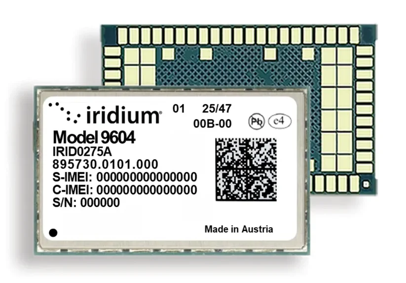
Iridium Communications, a provider of global voice, data, and positioning, navigation and timing (PNT) satellite services, has unveiled the Iridium 9604, a compact, three-in-one IoT module that integrates Iridium short burst data (SBD) satellite service, LTE-M cellular connectivity, and GNSS positioning into a single platform.
By combining these features in one device, the Iridium 9604 reduces solution complexity, lowers costs, and accelerates time to market, making dual-mode IoT connectivity viable for price-sensitive, high-volume deployments.
The Iridium 9604 beta program — launched earlier this year and oversubscribed by a select group of companies — has generated positive industry feedback highlighting:
Lower costs, simplified design, and enabling of location-aware network selection
Savings of 60 percent or more in board space with the 3-in-1 module, Iridium’s smallest ever form factor
Easy-to-use developer resources.
“As an early Iridium 9604 developer, utilizing the three-in-one module has already fundamentally changed our product economics,” said Alastair MacLeod, CEO, Ground Control. “We eliminated two components from our bill of materials, reduced our board size, and simplified our power architecture.”
MacLeod continued, “Additionally, having dual mode connectivity options enables a smarter, location-aware network selection in our application. The Iridium 9604 turned what would have been a complex multi-component design into a single-module solution. This is a major breakthrough for our IoT solutions.”
“Our customers require essential data and real-time intelligence to operate with confidence anywhere in the world,” said Dean Welten, CEO, Everlink. “By integrating the Iridium 9604 with our secure cloud platform, we can now enable global connectivity, greater operational efficiency, and measurable impact at scale.”
Representing the next phase of Iridium’s IoT strategy, the Iridium 9604 is moving the company beyond traditional satellite-only modules to a unified, multi-mode connectivity architecture. The Iridium network now offers customers three IoT service paths to follow:
Iridium SBD packaged with cellular and GNSS in the Iridium 9604 or SBD/Iridium Burst dedicated modules
Iridium NTN Direct for standards-based direct-to-device using third-party chips
Iridium Messaging Transport-based (IMT) for industrial-scale, larger payload capabilities with the Iridium Certus 9704
The Iridium 9604, built on the u-blox SARA-R5 platform, delivers a compact 16 mm x 26 mm x 2.4 mm form factor, best for dual-mode IoT deployments previously cost-prohibitive across industrial, infrastructure, and mobility applications.
Commercial availability begins in June 2026 with the Iridium 9604 Development Kit made available for testing satellite and cellular services. Reserve priority access at www.iridium.com/9604.
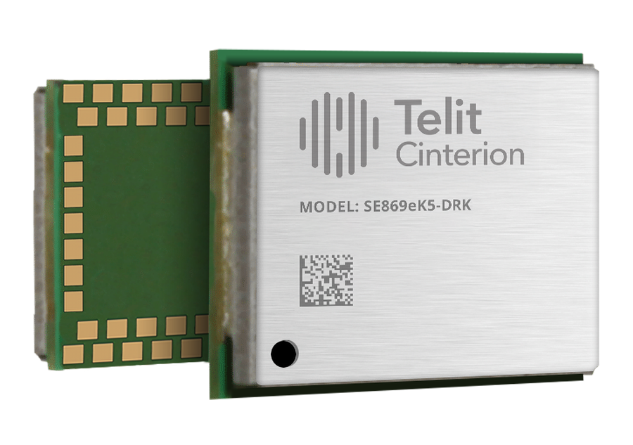
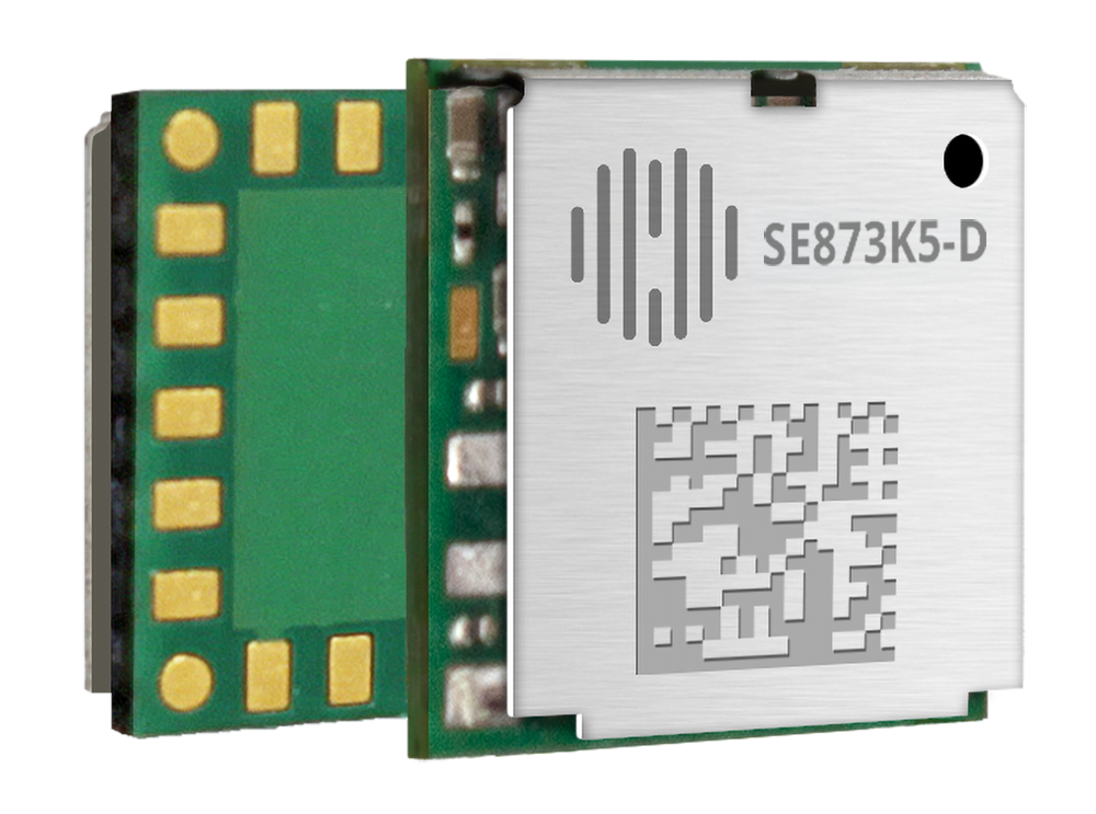
Telit Cinterion, an end-to-end IoT solutions enabler, has expaned its GNSS portfolio with two dual-band positioning modules: the ultracompact SE873K5-D and the high-end SE869eK5-DRK.
Built on the AG3335 chipset series from long-time partner Airoha, the new modules support space- and power-constrained internet of things (IoT) devices and use cases that require continuous, ultraprecise positioning.
The SE873K5-D and SE869eK5-DRK provide a scalable path to adopt dual-band L1 + L5 GNSS. Device manufacturers can add advanced correction technologies and resilient positioning architectures without redesigning hardware.
When combined with Telit Cinterion cellular connectivity solutions, the modules support the injection of RTCM corrections worldwide. This feature enables higher accuracy across connected IoT deployments.
SE873K5-D The SE873K5-D expands the established SE873K5 family with a dual-band L1 + L5 variant. It is designed for size- and power-constrained applications.
This new module maintains the same 7 x 7 mm footprint and pin-to-pin compatibility as the single-frequency SE873K5. OEMs can scale performance without changing hardware designs.
The SE873K5-D supports multiconstellation GNSS across the L1 and L5 bands. Compared to single-frequency solutions, it improves accuracy and robustness against interference and multipath effects.
With DGNSS support via RTCM corrections, the module enables submeter accuracy. It is ideal for myriad use cases, from wearables to fleet management.
Two power supply variants enable designers to optimize for either minimal size or ultralow power consumption in battery-operated devices. Multiple configurable usage profiles, such as tracking and drone modes, provide added flexibility across IoT verticals.
SE869eK5-DRK The SE869eK5-DRK is the next evolution of Telit Cinterion’s high-end GNSS offering. Based on the upper tier of the AG3335 chipset family, this module builds on the previously announced SE869eK5-DR. It adds support for RTK positioning with untethered dead reckoning.
This powerful combination enables uninterrupted, centimeter-level positioning. It maintains performance even when GNSS signals are degraded or unavailable due to interference or signal blockage.
The SE869eK5-DRK has an embedded inertial measurement unit. This feature helps maintain accurate position fixes in environments like tunnels and dense urban areas. The module supports DGNSS for submeter accuracy when RTK corrections are unavailable or when centimeter-level precision is not needed.
The SE869eK5-DRK is designed in an industry-standard 16 x 12.2 mm form factor. It introduces a proprietary extended pinout while remaining backward-compatible with existing designs. The added pins enable future-proof implementations and customization. OEMs can expand capabilities over time without redesigning their products.
Engineering validation testing samples of the SE873K5-D are available now. Design validation testing samples are expected soon. Mass production is planned for Q2 2026.
Design validation testing samples for the SE869eK5-DRK are available now. Mass production is planned for Q2 2026.
For more information about the SE873K5-D and the SE869eK5-DRK, visit Telit Cinterion at Embedded World at Booth #3-620. The event runs March 10-12 at the Exhibition Centre Nüremberg.
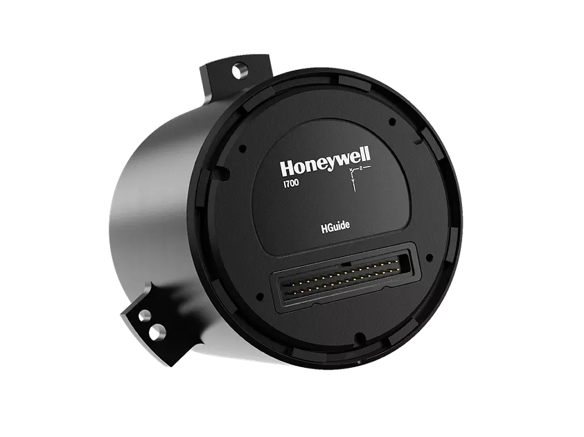
Honeywell has launched the HGuide i700, an inertial measurement unit (IMU) that delivers high-accuracy performance for unmanned air, land and sea vehicles. By pairing near navigation-grade capability with a no-license-required (NLR) classification, the HGuide i700 provides integrators worldwide with a powerful new option for critical sensing and navigation.
The HGuide i700 uses high reliability sensors and electronic architecture found in Honeywell’s HG3900 inertial measurement unit (IMU). Compact and low power, the HGuide i700 delivers near-navigation-grade accuracy and reliability while being optimized to support longer range navigation in GNSS-denied environments
“As customers explore new autonomous, robotic and precision-guided solutions, they want the accuracy and reliability of inertial systems that can be tailored to their program requirements,” said Matt Picchetti, vice president and general manager, Navigation and Sensors, Honeywell Aerospace. “The HGuide i700 offers strong GNSS-denied performance for by limiting maximum acceleration and spin rates in a license-free package that simplifies the complexity of system development while preserving reliability.”
The latest in Honeywell’s HGuide suite of no-license inertial solutions, the HGuide i700 allows customers to streamline development cycles, simplify system architecture and transition to field deployment more quickly than existing technology.
The HGuide i700’s rugged design, compact size and low-power profile make it suitable for diverse commercial, industrial and defense applications, such as:
Unmanned aerial, land or sea vehicles
Mobile mapping and surveying systems
Long duration unmanned ground or surface platforms
Robotics and industrial automation
Stabilized payloads and pointing systems
Honeywell has been a top innovator in IMU technology for more than three decades and pioneered the use of MEMS technologies in navigation. For more information about the Honeywell HGuide i700 and Honeywell’s navigation solutions, visit Honeywell Aerospace.
The war between Israel, the United States and Iran has dominated headlines since it began with surprise attacks launched by Israel and the U.S. on the last day of February. Significant damage has since been inflicted on Iran as the allies seek to end the country’s nuclear capabilities and bring about regime change — removing those responsible for worldwide terrorism through its proxy groups, including Hezbollah, the Houthi movement in Yemen, various Iraqi Shiite militias, Hamas and Islamic Jihad, all of which have targeted Western countries and Israel.
Iran maintains a formidable military with more than 600,000 active-duty personnel, an estimated 2,000 to 3,000 ballistic and shorter-range missiles, and a significant offensive drone capability. The Shahed series and Mohajer-6 drones have emerged as low-cost kamikaze weapons central to Iran’s arsenal. The Shahed-136 in particular has been supplied in large quantities to Russia for use in its ongoing war against Ukraine and is now also manufactured by Russia, or a version of it is. The Shahed drone has several variants, including the jet-powered, long-range Shahed-238.
Iranian Shahed-136 attack drones, read for launch. (Photo: IMA Media)
With a range of 800 miles to 1550 miles, the Shahed-136 carries an 88-pound warhead which can punch very large holes in buildings, disable oil tankers or warships, destroy equipment on the ground, and kill and injure lots of personnel. It’s possible that those six US servicemen killed and others injured during the early hours of the conflict in Port Shuaiba, Kuwait, were victims of a Shahed kamikaze drone attack.
This is not all bad news: the U.S. has analyzed captured downed Shahed-136 drones and has quickly replicated its own version, the Low-cost Unmanned Combat Attack System (LUCAS), admittedly with a shorter range but just as deadly. It’s reported that the Iranians can build and mass-produce thousands of drones for between $20 and $50,000 each. Nevertheless, the U.S. has now been producing large volumes of LUCAS, and has them to fight in Iran.
LUCAS is already in US volume production. (Photo: US Central Command)
Spektraworks, based in Phoenix, was awarded a $30 million contract, and within 18 months, a redesigned, hardened and autonomously coordinated attack drone — manufactured in the U.S. at a cost of approximately $43,000 per unit — became available in significant quantities and was fielded to U.S. Central Command’s newly formed drone task force, Task Force Scorpion Strike.
The unit was responsible for the Shahed-like drones seen flying over Baghdad in early television coverage as the U.S. offensive got underway.
It marks a notable achievement — delivering similarly designed attack drones, and the destruction they carry, back to Iran, a country that has exported terror to numerous nations for more than 50 years.
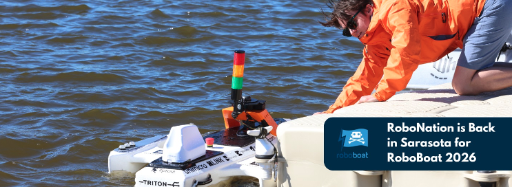
Meanwhile, the 2026 RoboBoat Competition took place at Nathan Benderson Park near Sarasota, Florida, drawing 37 high school and university teams. The event challenges students to demonstrate progress in developing autonomously operating marine systems installed on model boats. Benderson Park features a large rowing lake that has hosted Olympic rowing and canoe trials, making it a fitting venue for RoboBoat competitors and spectators.
Teams arrived with a wide variety of model boat designs and technical approaches, navigating through a series of in-water obstacle courses while gaining hands-on experience relevant to future careers. Volunteer support was plentiful, and each team brought cheering crews and technical assistance. Typical tasks included restoring simulated harbor operations, assessing underwater infrastructure and supporting exploration scenarios.
After watching more than 2 hours of posted videos, it is clear that the competition is run by a volunteer student organization. The final-round objectives were not clearly defined, and without commentary, it was difficult to determine whether any team successfully completed the obstacle course — though several boats did navigate between narrow red and green buoys after avoiding a series of posts in the water.
RoboBoat 2026
Nevertheless, it was great to see the whole gathering, many from overseas, and the level of enthusiasm. One guy told the story of how the team’s heavy equipment had survived a long-distance shipment from overseas and arrived almost intact. But during the competition, the quite heavy demo boat sank; it was just a minor setback for him — we’ll learn something and keep going! — was his mantra. As everyone in the industry knows, having your tested, verified, and 100% reliable set-up actually function at a trade show is a major hurdle we’ve all had to overcome. So, it’s good to see these young men and women learn firsthand what it takes to get a prototype to work when it becomes absolutely essential – and of course, to actually make progress and extend their reach towards autonomous robotics.
The U.S. military has been throwing Shahed-like kamikaze weaponized drones back at the country that had not only invented them, but also spread the technology to and through other antagonists, yet now feeling their impact on their own capital city — a significant success for the initial U.S. attack on Iran. And growing and supporting the latest wave of students and their autonomous aspirations at RoboBoat 2026 in Florida. One aspect of UAVs is warlike and deadly, while another is encouraging young engineering candidates towards their dreams of maritime robotic autonomy.
InfiniDome is set to debut its Aura GNSS protection system at XPONENTIAL Europe in Düsseldorf, Germany, March 24-26.
Aura supports two to four antennas and protects two GNSS frequency bands while passing two additional bands. The system can generate up to three nulls per protected band, allowing it to suppress multiple interference sources at once. The product is offered in two configurations: an enclosed version weighing 500 grams and an OEM version at 375 grams, the latter designed for integration into platforms where size and weight are constraints.
The company will also present IroNav, a navigation solution developed jointly with Wonder Robotics that combines InfiniDome’s anti-jamming technology with Wonder Robotics’ visual navigation and autonomy software. The layered architecture is intended to keep autonomous systems navigating when GNSS signals are degraded or unavailable entirely. IroNav is also making its European debut at the show.
InfiniDome recently entered the Indian market through a partnership with Globaz Technologies, which will serve as the company’s official partner in the country. The agreement is aimed at addressing demand for navigation resilience technology in India’s defense and unmanned systems sectors.
XPONENTIAL Europe is scheduled to take place this month in Düsseldorf, Germany.