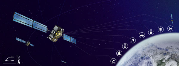
Lockheed Martin has developed a satellite-based augmentation system (SBAS), which uses signals from the GPS and Galileo constellations, according to a report by Space News.
The second-generation SBAS uses both GPS L1 and L5 and Galileo E1 and E5 signals to provide accurate navigation and positioning and to reduce dependence on just one system. The SBAS broadcasts on two frequencies to augment the signals from both GPS and Galileo.
Image: EUSPA
In September 2022, Lockheed Martin won a $1.18 billion 19-year contract to develop and operate the Southern Positioning Augmentation System Network (SouthPAN) for Australia and New Zealand. The company is also having discussions with other potential international customers.
As a part SouthPAN, the dual-frequency multiple constellation SBAS signal is being broadcast. As more GPS III and GPS IIIF satellites are launched, including one Jan. 18, service will continue to improve.
The Institute of Navigation (ION) has opened abstract submissions for Joint Navigation Conference (JNC) 2023, which takes place June 12–15 at the Town and Country Hotel in San Diego, California. JNC 2023 is the largest U.S. military positioning, navigation and timing (PNT) conference of the year with joint service and government participation.
Abstract selection for JNC 2023 is expected to be competitive, according to ION. All abstracts must be written for public release with intent to present in a Controlled Unclassified Environment (CUI) U.S. Only environment. Abstracts not meeting the established criteria, received by Feb. 3, will not be considered.
The event will focus on technical advances in PNT with emphasis on joint development, testing and support of affordable PNT systems, logistics and integration. From an operational perspective, the conference will focus on advances in battlefield applications of GPS; critical strengths and weaknesses of field navigation devices; warfighter PNT requirements and solutions; and navigation warfare.
CUI U.S. only conference attendance will be screened by the Joint Navigation Warfare Center and will be restricted to U.S. only. The exhibit hall (June 13-14) will be open to all conference participants, exhibitors, their employees and related organizations. All materials displayed in the exhibit hall must be publicly releasable after review.
Conveners of a session on GNSS applications for water vapor observations are seeking research paper submissions. The session will take place during the Asia Oceania Geosciences Society (AOGS) Conference 2023 taking place July 30 to Aug. 4 in Singapore.
Session AG06 is titled “Assimilation of Space- and Ground-based Water Vapor Observations for Weather Forecasting and GNSS Applications.”
Observation of water vapor is one of the priorities in the Global Climate Observing System. Obtaining and exploiting additional high-quality humidity observations from GNSS and other remote sensing techniques is essential to improve weather forecasting and climate monitoring, the session conveners explained.
Abstract contributions are being sought on the topic, such as:
new algorithms to estimate water vapor from ground-based and space-based techniques, such as ground-based GNSS, space-based RO, InSAR, visible/near-infrared/infrared/microwave sensors and other sensors
retrieval and inter-comparison of water vapor among multiple instruments
assimilation and analysis of water vapor products from ground-based GNSS, space-based RO, InSAR, and various remote sensing/meteorological satellites for nowcasting and weather forecasting
use of numerical weather prediction models for modeling outputs as atmospheric corrections for GNSS, InSAR, VLBI and other geodetic observation techniques
estimation of atmospheric parameters from crowdsourcing equipment
atmospheric products for climate, hydrology, natural disasters and others.
Paris Austin, head of product – New Technology for OxTS, tries out the new backpack at historic Minster Lovell Hall. (Image: OxTS)
More than 400,000 sites in the United Kingdom are on its historical registries. English Heritage site Minster Lovell Hall is located in Oxfordshire, also the home county of inertial navigation company OxTS. The picturesque ruins of Minster Lovell Hall, a 15th-century manor house, include the hall, a tower and a nearby dovecote.
The hall was built in the 1430s by William, Baron of Lovell and Holand — one of the richest men in England. It was later home to Francis, Viscount Lovell, a close ally of Richard III. After changing hands several times, the hall was abandoned and eventually demolished in the 18th century, leaving the extensive remains that stand today.
(Image: OxTS)
The buildings are grouped around a central courtyard in a plan characteristic of a late medieval manor house. For OxTS, the site proved suitable for testing its prototype backpack. The site features dense tree canopies on one side, tight doorways, narrow views of the sky, and plenty of height to test the angled mounting of the survey-focused lidar for when GNSS is denied. Open-sky areas allowed the OxTS team to return to real-time kinematic (RTK) surveying before moving on to another section of the site.
Reconstruction drawing of Minster Lovell Hall as it might have appeared in the 15th century, by artist Alan Sorrell. (Image: English Heritage)
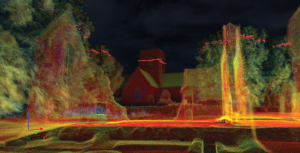
The prototype backpack is based on the OxTS setup for vehicles but was created to enable quick data collection without a car. It is equipped with two Hesai lidar sensors, a new OxTS prototype inertial navigation system and an antenna. The team can connect it to a laptop for configuration and to optimize lever arms and the boresight. Once post-processed with OxTS Georeferencer software, the point cloud below was produced.
OxTS designed the backpack to meet a growing need for localization and georeferencing in both GNSS-denied areas and those that cannot be reached by car, including the construction, environmental, conservation and heritage industries.
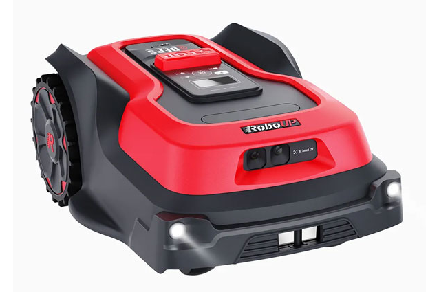
Another autonomous lawn mower has hit the field. The RoboUp (made by a company of the same name) is offering a no-perimeter-wire real-time kinematic (RTK) artificial intelligence (AI) robot lawn mower.
The mower uses an RTK module built into the charging station and AI real-time recognition support to automatically measure and profile a yard without any perimeter wiring or other installation.
RoboUp’s dynamic exact positioning system integrates RTK, visual simultaneous localization and mapping (SLAM) and an inertial measurement unit (IMU) to offer precise positioning with centimeter-level accuracy. It can also detect boundaries and identify obstacles and will stop cutting when it reaches either.
The robot lawn mower is powered by a maintenance-free brushless motor, which enables it to climb a 45% slope and cut different types of lawns, including over tough terrain. RoboUP is equipped with adjustable cutting heights of 30 mm to 60 mm and 20 cm width and can adjust the height of the cutting disc to match the terrain.
The mower can be controlled with its own app, which identifies the conditions of the user’s yard and generates a recommended cutting schedule. Additionally, it integrates with smart home systems and can be controlled by voice commands.
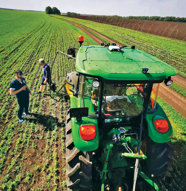
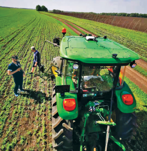
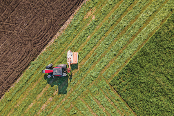
The earliest article about GPS and agriculture that I found in my collection of this magazine(*) is from the July/August 1992 issue: “Using GPS in Agricultural Remote Sensing,” by Eileen M. Perry of the Remote Sensing Research Laboratory of the USDA Agricultural Research Service. Thirty years later, you cannot buy a tractor from a major manufacturer that does not come equipped with a GNSS-based guidance system, and precision agriculture routinely makes use of remote sensing data and geographic information systems (GIS). The data are collected by Earth observation satellites, manned aircraft, UAVs and sensors on farm machinery. The GIS are used to collect, manage and analyze these data and create maps for the variable-rate machines to follow when seeding, irrigating, spraying fertilizer, herbicide and pesticides, and harvesting.
In this cover story, managers at Trimble, Tallysman Wireless, and ComNav Technology give their perspective on precision agriculture. Additionally, Gavin Schrock explains recently introduced options for tiered precise point positioning (PPP) services, using Trimble’s CenterPoint RTX as an example.
Proponents of precision agriculture and equipment vendors have always claimed that it reduces inputs (water, seeds, fertilizer and pesticide) and environmental impacts while increasing yields and profits. However, I have never been able to find any independent, reliable and comprehensive study of precision agriculture’s return on investment. If you are aware of any, please let me know, at [email protected].
— Matteo Luccio, Editor-in-Chief
Check out these perspectives on precision agriculture:
* I have the entire collection of GPS World’s print edition, except for the first issue, the 10 issues in the second year (1991), and the September through December 1993 issues. I would be thrilled to receive those missing issues, or facsimiles, from anybody who has them.
Correction services enable farmers to pinpoint where to apply fertilizers so as not to waste any. (Image: artiemedvedev/iStock/Getty Images Plus/Getty Images)
Growing among the many options for GNSS corrections open to precision agriculture operators are tiered precise point positioning (PPP) services. Agriculture has had integrated GPS, and now GNSS, for decades. Ranging from individual RTK bases, networks of RTK bases and network RTK (RTN) to dedicated L-band satellite-delivered PPP, operators have been able to receive and apply the appropriate corrections for different crops and applications, from centimeters to meters.
Part of the appeal of such services, particularly for large agricultural concerns with mixed crops and operations, is having the full flexibility of tiered precisions. Additionally, near-global coverage has increased utilization.
“Specialty and high value crops require high accuracy,” said Michael Helling, senior director of strategy for Trimble’s autonomy group. “For instance, when drip tape is laid for fruits and vegetables, you would not want subsequent activities to be off more than an inch or so, to avoid cutting it. This is where RTK was essential, and a base was often set up, or an RTN accessed. But the RTX [Trimble’s PPP delivered by L-band satellites] high-precision option, CenterPoint RTX, easily meets those needs.”
Like some other PPP correction services, Trimble’s RTX also has lower precision subscription options: RangePoint for 15 cm and ViewPoint for 30 cm pass-to-pass accuracy. These services are also utilized outside of agriculture. For example, CenterPoint, delivering centimeter precision, is utilized for certain surveying and construction applications and FieldPoint for asset mapping. Trimble has also developed embedded solutions, based on the same core technology for, among other things, maritime, robotics, autonomous vehicle, and assisted driving applications.
Certainly many agriculture applications can suffice with lower precisions, such as broadacre crops, where there may be no need to maintain row-to-row and year-to-year repeatability. Where some amount of overlap between passes is acceptable, coarse navigation at sub-meter to meter precision may be all that is needed. However, as Helling notes, precision becomes addictive, and as the field equipment becomes more capable of positionally topical functions, many operators are stepping up in levels of precision.
“Farmers are more precisely testing fields with all kinds of sensors and seeing where the field actually differs in soil and nutrient content,” said Helling. “There are different approaches and value propositions. One is saying I need to fertilize this area better so that I can get a better yield. There are also situations where a specific area of the field might only produce to a certain level. Farmers can pinpoint where those areas are to apply fertilizers so as not to waste it and optimize their bottom line.”
For many agriculture applications, the reality is that you have a tractor pulling some other piece of equipment through a field.
“Think about sprayers, forever behind a tractor,” said Helling. “Our equipment can control a lot of things around the rate, precisely targeting specific pieces of a field or row. When you start thinking about sustainability, being able to turn the spray on and off where you’ve already sprayed, you can avoid overspray.”
Sensor integration helps automate the process.
“We just aquired a company in France called Bilberry; their technology is very effective at identifying weeds. You can identify what’s in the field and can decide how you’re going to treat it. The next immediate steps in automation for agriculture might not be full autonomy, but more automation in the equipment that’s being pulled, and sensors that inform what they do.”
Tallysman antennas provide a critical link in the field for autonomous and semi-autonomous farm equipment. (Image: Kinwun/iStock/Getty Images Plus/Getty Images)
How do you define precision agriculture?
Precision agriculture includes all such modern technological advances as precise GNSS, robotics (autonomous vehicles, UAVs), sensors, and GIS that enable improved crop production by soil/field management and minimize the use of energy, seed, herbicides, pesticides and fertilizer.
What have been the key turning points in the development of precision agriculture?
There have been four key precision agriculture developments over the past 25 years. First, field mapping, which enables yield monitoring and the directed application of seed, fertilizer, herbicide and pesticide. Second, precision GNSS, which enables the same plus crop row offset from year to year. This offset, in turn, makes it possible to distribute the plant root system and utilize nutrients in different locations in the field, as well as to minimize soil compaction by ensuring that wheels do not travel over the same row from year to year. Third, autonomy, including UAVs and autonomous vehicles. Fourth, sensors to monitor moisture and water levels, and to identify weeds and plants.
What are the specific requirements and challenges of precision agriculture for GNSS, and how do they differ from those of other kinds of mapping and machine control?
Many precision agriculture applications require L-band corrections, which are typically broadcast from a geostationary satellite 35,800 km above the equator. The distance from the broadcast satellite to the user increases as the user travels either north or south of the equator. At the same time, the elevation angle decreases and at ~70° north or south of the equator the geostationary satellite will be seen at the horizon. As a result, at northern and southern latitudes, the L-band correction signal is seen at a low elevation angle and it is very weak because it has travelled a long distance. Tallysman has designed the VSS6037L antenna to receive L-band signals seen at low elevation angles.
When did Tallysman Wireless begin to focus on precision agriculture and why?
In September 2019, Tallysman Wireless released the VSS6037L agriculture and machine control GNSS antenna. Most GNSS/L-band antennas on the market have significantly lower gain at low elevation angles. Common GNSS antennas will provide good geostationary L-band reception from the equator to approximately 55° north or south latitude. However, as the arrival angle gets lower, a common GNSS antenna will have less gain and it will be challenged to receive the L-band signal at higher latitudes. Tallysman designed the VSS6037L specifically to provide support for all latitudes and specifically low elevation angle L-band signals received by users north or south 55° latitude.
What are your relevant products/product lines?
Tallysman Wireless has several GNSS antennas and smart GNSS antenna product lines that are designed for precision agriculture. The TW3972XF (triple-band plus L-band) and VSS6037L (full-band plus L-band) are ideal precision agriculture antennas. Tallysman has recently released the TW5390, which is a smart GNSS antenna that uses the u-blox F9P chipset and supports its PointPerfect L-band augmentation service.
For farmers, every centimeter counts. ComNav’s AG360 Pro autosteering system controls pass-to-pass accuracy within 2.5 cm. (Image: Daniel Balakov/E+/Getty Images)
How do you define precision agriculture?
Precision agriculture uses new technologies to obtain as much as possible the unique characteristics of a field and input the correct amount of resources at just the right time. It is a system that needs to be implemented throughout the whole process of crop growth, including land preparation, tractor guidance, water management and weather monitoring. Tractors are used at every step, therefore it is critical to make them work consistently throughout the whole process, by using GNSS. ComNav Technology’s autosteering systems can be installed on most types of tractors. This allows farmers to grow the crops in a more autonomous and efficient pattern, which they can then save with high precision and reuse for later steps until harvest, increasing the utilization rate of land and decreasing the use of fuel, water, fertilizer and herbicides.
What have been the key turning points in the development of precision agriculture?
We have been in this sector since 2013. Our current solution is much easier to install and maintain and has higher accuracy and stability. The younger generation of farmers are more receptive to autonomous driving. They would like to try new things and set themselves “free” with technology.
What are the specific requirements and challenges of precision agriculture for GNSS, and how do they differ from those of other kinds of mapping and machine control?
The main challenges for autosteering systems include signal loss and terrain compensation. Most rural areas lack GSM coverages; therefore, in many countries using autosteering requires base stations. However, radio data links between stations far apart could be affected by obstacles, causing frequent correction outages. To compensate for this, ComNav has embedded in its GNSS module its “RTK-Keep” algorithm, which can maintain a relatively high-precision performance for autosteering during corrections outages. The system also must include various terrain compensation algorithms that identify a field’s elevation contours and provide smooth and continuous guidance even in complex terrains.
When did ComNav begin to focus on precision agriculture and why?
In 2013, we introduced our first high precision GNSS board. Initially, our main role was to provide it to integrators with expertise in precision agriculture. Over the years, the market began to boom in China and in 2016 we announced our first generation autosteering system for tractors. The main reason for us to focus on precision agriculture is the increasing demand from the market, which we believe will continue to grow in the foreseeable future due to the increasing demand for food from Earth’s growing population.
What are your relevant products/product lines?
In the past, workers in China drew lines on the land and then planted potatoes roughly along those lines, which was challenging and time consuming. It was hard for the farm owner to hire an experienced driver and guarantee the effectiveness of seeding. Now, however, ComNav Technology’s AG360 Pro autosteering system solves that problem by guiding vehicles according to set routines, including straight lines, curves, automatic turns and headline turns. Importantly, the pass-to-pass accuracy can be controlled to within 2.5 cm. The worker can finish multiple processes within only 24 hours, such as ridging, ditching, sowing, fertilizing and laying drip irrigation under mulch. Furthermore, compared to traditional manual planting, mechanized planting produces a more even sowing rate, which also establishes the foundation for the automated harvesting of potatoes. Potato production has increased by 10% per acre, land use has been reduced by more than 20%, and labor costs have been reduced significantly.
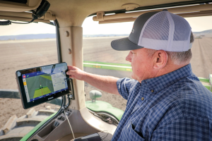
With the aid of Trimble’s correction services, the in-cab GFX-1260 display connects farmers to a wealth of knowledge about their fields and crops. (Photo: Trimble)
How do you define precision agriculture?
Precision agriculture is the use of technology in farming to increase yields through data and precision. Precision ag helps farmers improve yields by collecting data on all aspects of each plant to figure out exactly what it needs, when it needs it and how it will best survive. From planting, growing and cultivating to spreading, spraying and harvesting, precision agriculture allows farmers to monitor, measure and utilize data from beginning to end.
What have been the key turning points in the development of precision agriculture?
Accurate positioning is the enabler for all precision agriculture. RTK was one of the biggest initial developments within positioning as it allowed farmers a higher level of accuracy than had been seen previously. Precise Point Positioning (PPP) was the next big development. Our version of PPP, Trimble RTX, allows farmers the best of both worlds — RTK-level accuracy delivered via satellite, eliminating the need for base stations or sometimes unreliable radio, cell or internet signals. Though precision agriculture started with guidance, it has now made its way to implement-level, variable rate seeding and spraying and section control. ISOBUS has also been a big development in the past few years — allowing machines of all types to interact and communicate with each other, regardless of type, color and shape.
What are the specific requirements and challenges of precision agriculture for GNSS, and how do they differ from those of other kinds of mapping and machine control?
The challenge in GNSS is providing customers with the greatest availability in the field. While most fields are under open sky, obstacles such as trees and gullies make it more challenging. At Trimble, we provide market-leading pass-to-pass value with limited overlap for the customers at different price points. With our latest and most premium correction service, CenterPoint RTX, ease of use is also a key benefit.
When did Trimble begin to focus on precision agriculture?
Trimble unveiled its first agriculture receivers in 1999, signaling the start of the Trimble Agriculture division. In 2000, AgGPS Autopilot and automated steering systems were released for row crop application, further cementing Trimble’s presence in the precision agriculture community.
What are your relevant products/product lines?
Trimble offers technology integration that allows farmers to collect, share, and manage information across their farms, while providing improved operating efficiencies in the agricultural value chain. Trimble solutions include both hardware and software for guidance and steering, flow and application control, water management, harvest solutions, desktop and cloud-based data management, and correction services. Trimble’s CenterPoint RTX satellite-based correction service delivers GNSS positions repeatable to less than an inch. Combined with Trimble’s ProPoint GNSS technology, this service provides greater positioning availability, even in challenging environments such as tree lines, gullies and along contours where much of farming takes place.
For applications where centimeter-level accuracy is not as high of a priority, such as broad acre applications, Trimble RangePoint RTX and ViewPoint RTX give additional correction service options. They hold equipment to 6-inch and 12-inch pass-to-pass accuracy — or about the width of a tire between passing swaths. Trimble also offers Trimble VRS Now, giving farmers instant access to RTK positioning services using a network of permanent, continuously operating reference stations.
The U.S. Space Force (USSF) has delivered two payloads to Japan for the Quasi-Zenith Satellite System (QZSS). The payloads will be integrated into two QZSS host satellites being prepared for launch, which will expand the QZSS constellation from five to seven satellites.
The QZSS hosted payload (QZSS-HP) is central to the USSF priority of expanding cooperation to contribute to international security. The mission is managed by the Space Domain Awareness and Combat Power Directorate (SDACP) of the Space Systems Command (SSC) within the USSF.
Massachusetts Institute of Technology’s Lincoln Laboratories (MIT/LL) is the primary payload developer for the QZSS-HP. MIT/LL and USSF personnel will travel to Japan to support the integration and test efforts with Japanese partners until both QZSS host satellites are launched.
Movella, a leading provider of sensors and software, has launched a partnership with Fixposition, a manufacturer of precise positioning sensors. The partnership aims to develop and commercialize GNSS inertial navigation sensors and implement visual inertial odometry through new products.
In December 2022, Movella and Fixposition launched the first product from the partnership, the Xsens Vision Navigator. This product integrates position inputs from three high-accuracy sources including dual-antenna RTK GNSS receivers, an IMU incorporating a three-axis accelerometer, gyroscope and magnetometer and a visual inertial odometry system.
The Xsens Vision Navigator can optionally accept inputs from an external wheel speed sensor. The positioning sensor achieves centimeter-level accuracy when operating in GNSS mode with an RTK fix. When GNSS signals are not available, the product alone achieves an accuracy of 2% of travel distance, or 0.75% when supplemented by wheel speed.
Xsens Vision Navigator is suitable for outdoor positioning applications such as material handling equipment, commercial and specialist vehicles, last-mile delivery, inspection equipment and UAVs, agricultural equipment, mining equipment and utility robots.
Xsens Vision Navigator is available now from Movella or authorized distributors of Xsens products.