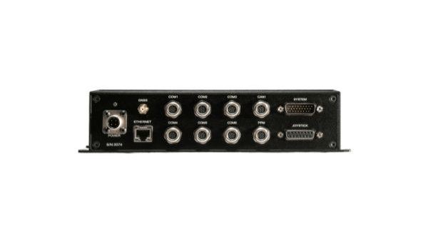
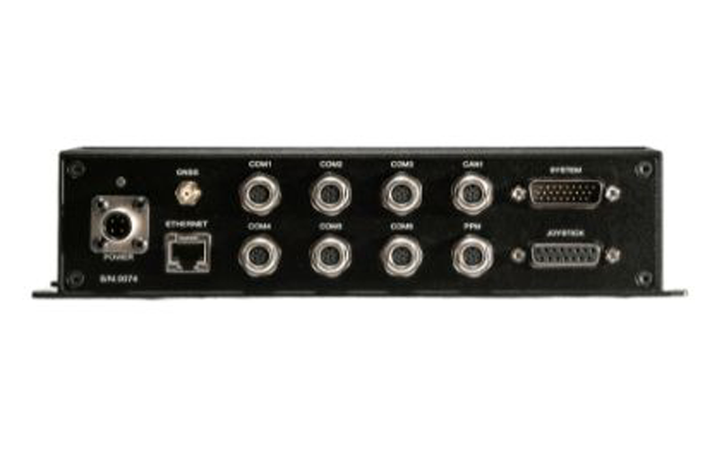
UAV Navigation-Grupo Oesía has released the GHU-100 ground control hub unit that helps platform manufacturers connect multiple ground devices to form a single network segment.
The GHU-100 enables multi-UAV and multi-ground control system (GCS) operation and is also designed to fulfill all requirements of maritime operations. This includes control of NMEA inputs, real-time kinematic corrections, and more. The ground control station hub unit also increases UAV flight safety, as it is independent from the computer OS and its potential PC crashes.
The GHU-100 is designed to increase a system’s robustness while maintaining a high flexibility with its extensive input/output capabilities, which makes it easy to integrate into complex and advanced GCS architectures. It also implements critical functionalities on a self-developed real-time operating system to ensure secure missions in all environments.
Indiana state legislators have filed multiple bills that would make tracking someone with a GPS-based device without their knowledge a crime, reported WTHR of Indianapolis. The bills are in response to the growing number of criminal cases involving Apple AirTags and other GPS-based tracking devices.
Tracking someone secretly is not currently a crime in Indiana; however, laws vary from state to state. Under one proposed bill, the penalty would be increased from a Class C misdemeanor to a Class A misdemeanor if the person tracked is under a protective order. The penalty could be enhanced for someone convicted of using tracking devices when committing a felony.
Similar incidents are on the rise around the United State regarding the use of AirTags and other tracking devices for criminal purposes. In December 2022, two women in California filed a class-action lawsuit against Apple for privacy concerns after being stalked by ex-partners using AirTags.
A roundup of recent products in the GNSS and inertial positioning industry from the January 2023 issue of GPS World magazine.
SURVEYING & MAPPING
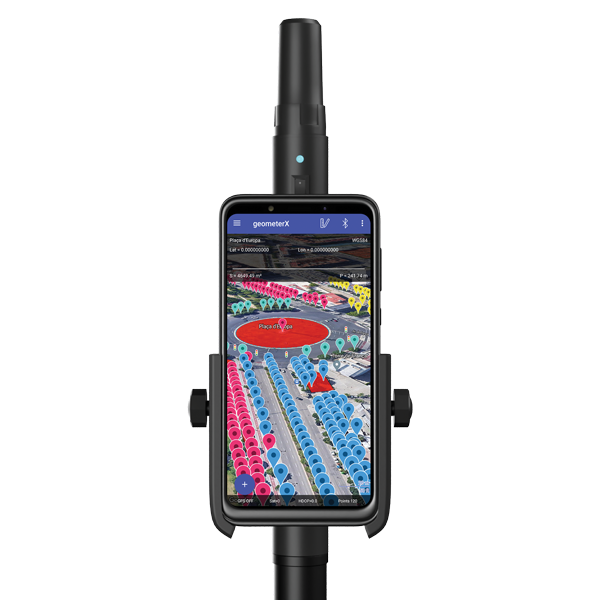
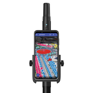
Image: Geometer International
Dual-Frequency Receiver
Receives all GNSS constellations plus SBAS
The Walker RTK is a dual-frequency GNSS receiver (L1, L2) for high-precision coordinate surveying in real-time kinematic (RTK) mode. It comes with a helical antenna, a bracket for attaching a smartphone, and the Geometer SCOUT mobile app. A classic geodesic antenna can be connected through the SMA connector. The Walker RTK has a rugged aluminum alloy casing with a shock-resistant coating, yet weighs only 250 grams. GNSS signals processed by the Walker RTK GNSS receiver include GPS (L1C/A, L2C), GLONASS (L1OF, L2OF), Galileo (E1B/C, E5b), BeiDou (B1I, B2I), QZSS (L1C/A, L1S, L2C) and SBAS (L1C/A). A built-in rechargeable battery provides 24 hours of continuous operation without recharging.
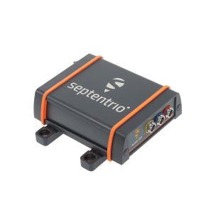
The AsteRx SB3 ProBase creates high-quality measurements for real-time kinematic (RTK) and differential corrections. The IP68-housed GNSS base station receiver features the latest quad-constellation GNSS technology and complements the SB3 receiver family: the AsteRx SB3 Pro rover receiver, the AsteRx SB3 Pro+ rover and base receiver, and the AsteRx SB3 CLAS for the Japanese market. The SB3 ProBase is easy to configure, the company says. It comes with Septentrio’s GNSS+ technologies, including anti-jam and anti-spoofing technology (AIM+) for robustness and reliability. AsteRx SB3 products are pin-to-pin compatible with the AsteRx SB ProDirect receiver and the recently released AsteRx SBi3 GNSS/INS system.
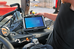
The Algiz 10XR is a rugged 10-inch Windows tablet that combines durability with a GNSS receiver and 5G communications. It was developed for challenging environments in logistics, mining, public transport, public safety, waste management or geographic information systems (GIS). The 10xR is customizable and has a dedicated multiband GNSS u-blox NEO-M8U receiver for accurate positioning as well as untethered dead-reckoning technology. The high-resolution, sunlight-readable 10-inch touchscreen has super-hardened glass and rain-and-glove mode. The tablet also has 4G/LTE high-speed data, Wi-Fi and Bluetooth.
The VZ-600i terrestrial laser scanner has a 3D position accuracy of 3 mm and less than 30 seconds of scan time for high-resolution scans with 6 mm point spacing at 10 m. This enables more than 60 scan positions per hour with real-time registration. Weighing less than 6 kg (13 pounds), the VZ-600i has a 2.2-MHZ pulse repetition rate, three internal cameras and an integrated GNSS receiver. It also includes key features to speed up workflows in indoor and outdoor applications such as architecture, engineering, construction, building information modeling, as-built surveying, forensic and crash scene investigation, archaeology and cultural heritage documentation and forestry.
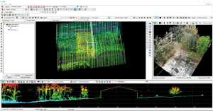
The LP360 Drone software system provides a geospatial-data workflow for UAV lidar and photogrammetry data processing. It provides powerful point cloud visualizations with multiple, synchronized windows. It can transform lidar and imagery data into survey-grade deliverables including visualization, quality checks, classification, analysis and 3D editing. For users of larger datasets, LP360 Geospatial can process captured lidar data or images from any aircraft or mobile sensor and analyze and extract values.
Free library offers data on healthcare, business, traffic
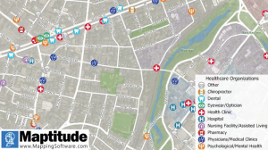
The extensive Maptitude library of free mapping databases has been updated for 2022 and is available for download, supporting insightful business development analysis. The data is available free to users of the latest version of the Maptitude mapping software. The data are also available as shapefile, KML, KMZ or GeoJSON for a fee. Maptitude includes business-critical data such as demographics, boundaries, streets, and the most ZIP Code/postal boundaries. Also available is a catalog of free premium datasets that can be used in other GIS applications, on the web, or in corporate databases.
Indoor and outdoor tracking of low-power, small IoT devices
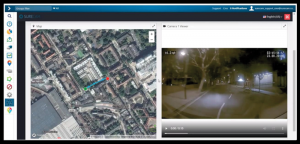
Traxmate is integrating Nestwave GNSS location technology into its asset-tracking platform for seamless indoor and outdoor positioning, tracking and routing of small, low-power and battery-powered devices for the internet of things (IoT). Nestwave’s NestCore IP and NestCloud cloud services enable power-efficient geolocation solutions, while Traxmate (pictured) is a comprehensive data-processing hub that simplifies setup of tracking environments and provides real-time visualization of device location. The resulting geolocation solution is suitable for applications ranging from carrier tracking to tracking individual parcels and packets. Traxmate is simple to use and set up, requires no coding, and provides an out-of-the-box feature set that includes dashboards, alerts and processing rules for taking actions on incoming data. Nestwave’s trackers include ThinTrack, an ultra-low-profile, compact GPS tracking solution that integrates an LTE-M/NB-IoT modem, antenna, battery and SIM into a device that measures 82 mm x 35 mm x3 mm and weighs 15 g.
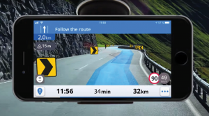
Provides guidance even without an internet connection
The Sygic GPS Navigation app uses a smartphone’s camera and augmented reality to display navigation instructions over the view ahead on the windshield. The head-up display is especially useful at night, enabling recognition of critical speed limit, road work or traffic restriction signs. Cockpit is a powerful tool that shows the real-time performance of the car, measuring the G force and actual speed to help users drive economically. The Dashcam feature records the road ahead and automatically saves the video in case of an accident. An Electric Vehicle Mode locates nearby charging stations.
Enhanced data-based rule implementation for fleets
An enhanced SureCam video telematics integration provides fleet managers with access to new capabilities to keep drivers safe and maximize fleet efficiency. The solution features a method for capturing video footage from SureCam cameras using Geotab’s powerful telematics device and rule-based system. The result is a seamless display of video within the MyGeotab platform. The enhanced SureCam fleet video solution leverages Geotab’s numerous data-based rules, such as improper seat belt usage and speeding. It uses G-force triggered alerts that detect unsafe driving behaviors and automatically captures video footage that can be reviewed later on the MyGeotab platform and alert managers to incidents when necessary. Camera configuration and customized triggers are managed directly within MyGeotab.
Driver 2.0 is a Level 4 production-ready autonomous driving solution that can operate in complex and challenging traffic environments. Demonstrations with Driver 2.0 showed an autonomous vehicle could maneuver around double-parked cars, e-scooters and pedestrians, negotiate oncoming vehicles to calculate the right timing and trajectory to pass busy intersections, and make multiple lane changes and unprotected left turns. In the case of long tail scenarios, the system will alert the remote monitoring center to intervene or take other safety measures. Driver 2.0 includes five solid-state lidar units, eight cameras and other sensors, and a computing platform integrated with a proprietary inference engine. The perception algorithm with sensor fusion can achieve precise object detection up to nearly 220 yards. The planning and control algorithm based on game theory can choose optimal routes and make decisions based on real-time situations when negotiating with oncoming vehicles and other road agents.
Provide improved signal gain for automotive antennas
Two new compounds could improve signal-gain performance compared to ceramics in second-generation automotive GNSS antennas. The new compounds — LNP Thermocomp ZKC0CXXD and LNP Thermocomp ZKC0DXXD — help enable the design and molding of antenna substrates with more complex pattern markings that add effective surface area, a critical factor in enhancing signal capture. They also provide flexibility to produce smaller parts with the same performance as ceramic, or equal-size parts with better performance. The LNP Thermocomp compounds feature electroplating capability, good thermal resistance for reliability, and the design freedom and production efficiency of thermoplastics. Both are well-suited for shark-fin-style and new conformal antenna designs.
SABIC, sabic.com
AUTONOMOUS
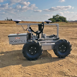
Image: Civ Robotics
Robotic Surveyor
Precisely marks thousands of coordinates per day
The CivDot unmanned ground vehicle (UGV) is designed for civil engineering and infrastructure projects such as solar farms, roadways, data centers, power plants and more. The autonomous surveying robot is designed to increase efficiency, productivity and safety on the job. Augmenting the surveyor’s work, CivDot marks thousands of coordinates per day precisely and efficiently, while delivering layouts faster than traditional methods. Civ Robotics uses Trimble’s high-precision GNSS positioning technology and surveying software.
The compact DJI Mavic 3E and 3T drones have been designed for an array of commercial missions. Flight time is 45 minutes. Both models have a real-time kinematic (RTK) module that enables surveying professionals to achieve centimeter-level accuracy with support for network RTK, custom network RTK services, and the D-RTK 2 Mobile Station. The D-RTK 2 Mobile Station is DJI’s upgraded high-precision GNSS receiver that supports all major GNSS, providing real-time differential corrections. The DJI Mavic 3E enables efficient mapping and surveying missions without the need for ground control points. The DJI Mavic 3T is engineered for aerial operations in firefighting, search and rescue, inspections and night missions.
AlphaRTK has signed agreements with Rutgers University, West Chester University and Warren County Community College to provide free access to its GNSS correction network for students and faculty.
The AlphaRTK network — an affordable RTK subscription network that supports four constellations — launched in 2021 and is available for use in New Jersey as well as both the New York City and Philadelphia metropolitan areas.
All institutions perform geospatial research and instruction. Having access to the AlphaRTK network is a powerful resource and will enhance the performance of modern geospatial data collection, the company said.
Warren County Community College specializes in precision agriculture using drones. The AlphaRTK network will provide its fleet with centimeter-level accuracy, advancing analytical capabilities. Rutgers University plans to advance turf farm research, and West Chester University aims to use the network for a geophysics course, among more geospatial research.
AlphaRTK records raw RINEX data that can be used for post-processing workflows, such as with post-processed kinematic drones. Additionally, in southern New Jersey where wireless coverage is weak, Alpha RTK has added ultra-high frequency radio transmitters to broadcast real-time data wirelessly.
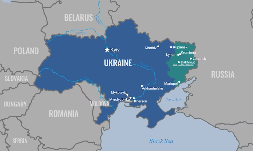
The United States Department of Defense (DOD) will provide a new package of security assistance for Ukraine to aid with ongoing Russian aerial attacks. The package includes defense tools such as GPS-guided rockets and counter-UAV equipment.
The presidential drawdown package includes:
additional ammunition for High Mobility Artillery Rocket Systems
additional 155 mm artillery rounds
additional 120 mm mortar rounds
190 heavy machine guns with thermal imagery sights and associated ammunition to counter unmanned aerial systems
181 Mine Resistant Ambush Protected vehicles
250 Javelin anti-armor systems
2,000 anti-armor rockets
Claymore anti-personnel munitions
demolitions munitions
cold weather gear, helmets and other field equipment.
Under the Ukraine Security Assistance Initiative (USAI), DOD will provide Ukraine with:
two HAWK air defense firing units
anti-aircraft guns and ammunition
equipment to integrate Western air defense launchers, missiles and radars with Ukraine’s air defense systems
equipment to sustain Ukraine’s existing air defense capabilities
air defense generators
counter-unmanned aerial systems
four air surveillance radars
20 counter-mortar radars
spare parts for counter-artillery radars
Puma unmanned aerial systems
precision-guided rockets
secure communications equipment
medical supplies
funding for training, maintenance and sustainment.
Ukraine has been able to intercept Russian UAVs and missiles; however, having additional air defense will help combat efforts.
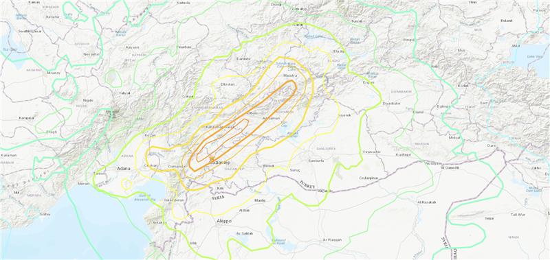
Three earthquakes of magnitude 6 or larger have occurred in Turkiye and northern Syria since 1970. The largest was a magnitude 6.7 earthquake in January 2020. (Credit: USGS)
On Feb. 6, a magnitude 7.8 earthquake struck Turkiye and northern Syria collapsing buildings and killing more than 2,000 people, followed by magnitude 6.7 aftershocks. The impact of the earthquakes was significant and ranks in the red for economic losses and orange for fatalities, according to the United States Geological Survey (USGS).
The USGS reports the earthquake resulted from strike-slip faulting at shallow depths. It appears to be associated with either the East Anatolia fault zone or the Dead Sea transform fault zone.
Historical buildings throughout Turkey have been severely damaged, including the Yeni Mosque and the Gaziantep Castle, which date back thousands of years.
War-torn Syria — specifically Aleppo, Hama and Latakia — have also sustained severe damage to infrastructure that was already fragile.
The effects of this earthquake were felt as far as Lebanon and Israel.
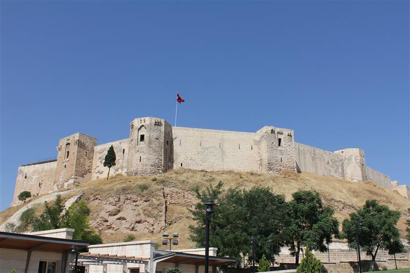
Parts of the historic Gaziantep Castle collapsed, as it lies close to epicenter of the magnitude 7.8 earthquake. (Image: JudyDillon/ iStock / Getty Images Plus/Getty Images)
Historical Gaziantep Castle’s east, south and southeast bastions collapse, leaving debris scattered on the road after major 7.4-magnitude earthquake struck Türkiye’s southeasthttps://t.co/5j2soYI6hCpic.twitter.com/1n6whCr2gY
The Choctaw Nation of Oklahoma (CNO) Beyond Program and uAvionix have received approval from the Federal Aviation Administration (FAA) for beyond-visual-line-of-sight (BVLOS) operations. The approval signifies uAvionix and the CNO have demonstrated to the FAA that the aircraft procedures, detect-and-avoid systems and control network meet the safety requirement for operation in the national airspace.
This is the second BVLOS waiver granted by the FAA for the combinations of uAvionix SkyLine software and SkyLink hardware, allowing UAV pilots operating at the CNO range to use only an electronic observer.
The CNO will be using uAvionix SkyLine command-and-control (C2) management platform and pingStation3 dual-mode ADS-B receivers at the Emerging Aviation Technology Center UAS Test Range. The SkyLine C2 management platform is integrated with the DeTect Harrier radar for surveillance, and is used to control several CNO and uAvionix owned electric vehicle takeoff and landing aircraft through muLTElink and SkyLink series C2 radios.
“Having this capability available at CNO enables our customers to conduct testing and demonstration in Oklahoma and will further serve as guidance for future applications leveraging this concept of operations,” said uAvionix President Christian Ramsey.
Transport Canada has approved Ontario Power Generation (OPG) to operate Percepto’s drone-in-a-box solution beyond visual line of sight (BVLOS) at McConnell Lake Control Dam without a visual observer on site. A BVLOS Special Flight Operations Certificate was issued for the Percepto Air Max autonomous drone-in-a-box for the remote inspection.
The approval enables remote inspection of the dam as a part of a pilot project, which started in January. Since Canadian power utilities are seeking to ensure their power grid and stations are resilient, the OPG facility will gain actionable insights from the remote inspection.
Percepto’s automated drone-in-a-box has been deployed by other electric utilities to monitor the durability of power grid infrastructure and quickly detect problems, enabling faster response times and restoring power quicker after storms and natural disasters.
EagleView Technologies is enhancing EagleView Cloud for government users by adding more imagery options. EagleView Cloud is a resource for government departments including tax assessment, geographic information systems and public safety.
Image: Eagleview
EagleView cloud will now include 1-inch ground sample distance (GSD) aerial imagery. The oblique imagery, usually captured at a 40°- 45° angle, provides enhanced clarity and side-angle views of buildings, homes and properties, enabling government users to view property changes and analyze roads and infrastructure to produce accurate tax assessments.
The company has also added 3-inch GSD orthogonal imagery to the platform. The orthogonal images help government users identify structural changes to buildings, additions to homes, and the condition of impervious surfaces. The images offer a top-down view and can be delivered annually or multiple times per year.
Next, EagleView Cloud aims to be available in commercial industries including insurance, construction and solar.
SandboxAQ has been awarded a Direct-to-Phase-II Small Business Innovation Research contract by the United States Air Force. SandboxAQ will test and evaluate its quantum sensor prototype to help protect military navigation resilience.
Under the contract, SandboxAQ will advance research and development for its quantum navigation system, which is being designed to complement GPS. It will be used for accurate navigation in contested or denied environments where the loss of precision GPS may negatively impact operations.
SandboxAQ’s AQ-powered quantum sensor prototype will be optimized in close coordination with USAF through identified innovation areas, including live demonstrations aboard USAF aircraft. The sensor prototype also has potential for use in the commercial sector for aviation, unmanned vehicles and more.
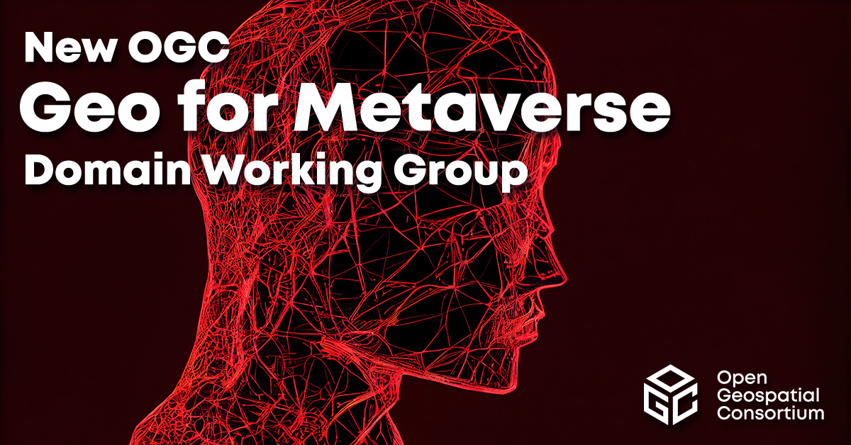
The Open Geospatial Consortium (OGC) has formed the Geo for Metaverse Domain Working Group (DWG), which will serve as a forum for the collective geospatial expertise of the OGC community to gather to help build and expand the open Metaverse. The group is open to both OGC members and non-members.
The group plans to contribute its expertise in 3D, modeling and simulation, artificial intelligence, digital twins, streaming, augmented and virtual realities, routing, mapping and more — all at scale.
The group will work on pieces of the Metaverse that pertain to geospatial applications and standards by identifying standardization activities and best practices based on FAIR (making data Findable, Accessible, Interoperable and Reusable) data principles.
The DWG will be the primary point of contact with the Metaverse Standards Forum, of which OGC is a founding and principal member.
3D geospatially anchored data is powering innovation across a range of industries. This same data — relied upon for construction of the real world — is now driving the creation of virtual/digital worlds that will form parts of the Metaverse.
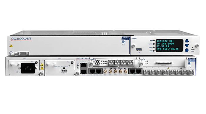
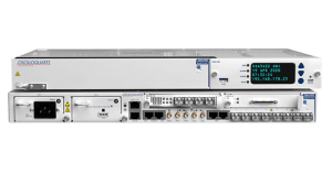
ADVA and Brandywine Communications have partnered to provide a defense-grade M-code device with advanced timing, the OSA 5422 grandmaster clock, for military applications. ADVA’s OSA 5422 meets key requirements of military networks by providing advanced positioning, navigation and timing (PNT) capabilities and improved resilience.
ADVA’s OSA 5422 grandmaster clock is integrated with a highly reliable M-code receiver, which meets stringent frequency and phase synchronization needs. The device is equipped with multi-band, multi-constellation GNSS receivers for when M-code is not available. OSA 5422 also has long holdover and precision time protocol backup, which enables it to maintain accurate timing even in the event of M-code disruption.
The OSA 5422 supports legacy interfaces such as BITS and IRIG and features eight field-upgradable 10G bit/s ports and 1G bit/s interfaces. The device is suitable for most demanding military edge applications.