Category: Applications

  • Launchpad: Professional UAVs, Android mapping, video telematics

    Launchpad: Professional UAVs, Android mapping, video telematics

    A roundup of recent products in the GNSS and inertial positioning industry from the May 2022 issue of GPS World magazine.


    SURVEYING

    Measurement Workflows

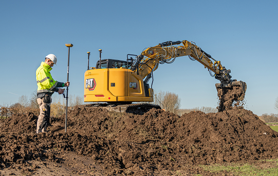
    Field-to-office inspection with survey-grade accuracy

    Photo: Trimble
    Photo: Trimble

    Trimble Access field software now connects with Infotech’s Appia service to streamline the workflow from survey to construction. Aimed at the inspection process for civil infrastructure projects, the software provides high-accuracy measurement workflows for daily work reports and inspection reporting for engineering, construction and public agencies. By streamlining the connection between data collected by Trimble GNSS rovers and simultaneously syncing Trimble Access, Infotech Mobile Inspector and Infotech Appia, inspectors can now complete their daily work reports more efficiently in the field and reduce errors. With manual processes removed, inspectors can more accurately represent infrastructure assets.

    Trimble Geospatial, geospatial.trimble.com; Infotech, infotechinc.com

    GNSS Receiver

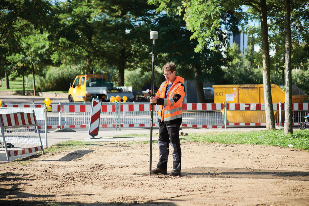
    For surveying, mapping and construction professionals

    Photo: CHCNav
    Photo: CHCNav

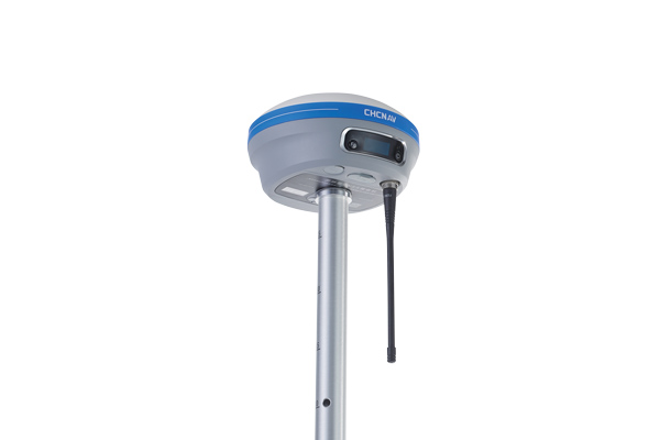
    The i83 GNSS receiver is powered by a multi-band GNSS receiver, iStar technology, and a calibration-free, high-end inertial measurement unit (IMU) for faster and reliable field GNSS surveying. The third-generation high-gain antenna with advanced CHCNAV iStar algorithm improves GNSS satellite signal tracking efficiency by more than 30%. The i83 GNSS receiver features 1,408 GNSS channels for high performance across GPS, GLONASS, BeiDou, Galileo and QZSS constellations. Its onboard GNSS technology delivers centimeter-level positioning, maintains reliable fixed real-time kinematic (RTK) accuracy, and collects points faster than previous models, even in demanding conditions. The i83 receiver’s built-in IMU automatically compensates for pole tilt. In less than 5 seconds, the 200-Hz inertial module is initialized to ensure survey-grade accuracy over a pole-tilt range of up to 30 degrees. Productivity is dramatically increased, RTK usability greatly improved, and potential human error reduced, whether you are an engineer, site foreman or surveyor.

    CHC Navigation, chcnav.com

    Survey Software

    Simplifies surveying with both GPS and total station

    Photo: Carlson Software
    Photo: Carlson Software

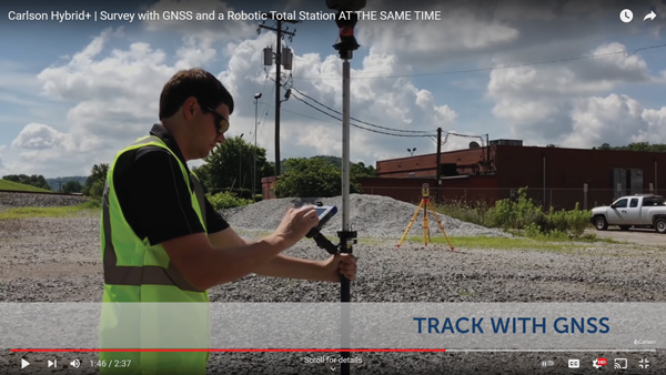
    SurvPC Hybrid+ is a module for SurvCE version 6 software that enables surveying with mixed brands of GNSS receivers and total stations. SurvCE is a data-collection software package from Carlson Software. SurvPC Hybrid+ provides driver support for numerous devices, allowing the surveyor to interface with both types. Features include Follow Me, Smart Lock, Smart Staking, Cross Check, Backup Tracking, Hybrid-Resection, Auto-Localize, and Easy Setup Wizard.

    Carlson Software, carlsonsw.com

    Data-Collection Software

    Runs on Android devices

    Photo: eSurvey
    Photo: eSurvey

    SurPad 4.2 is designed to help surveyors work efficiently at all types of land surveying and road engineering projects in the field. It runs on eSurvey handhelds, Android smartphones and tablets, and third-party Android devices. It integrates with professional receiver control, point collection, stakeout, geographic information system (GIS) data collection, road measurement, road design, cross-section measurement and railway stakeout. SurPad 4.2 provides multiple operation and communication systems, has mapping and CAD functions, and has a coordinate system. It also includes a survey mode encompassing topo, control, quick point and COGO civil engineering programs.

    eSurvey, esurvey-gnss.com
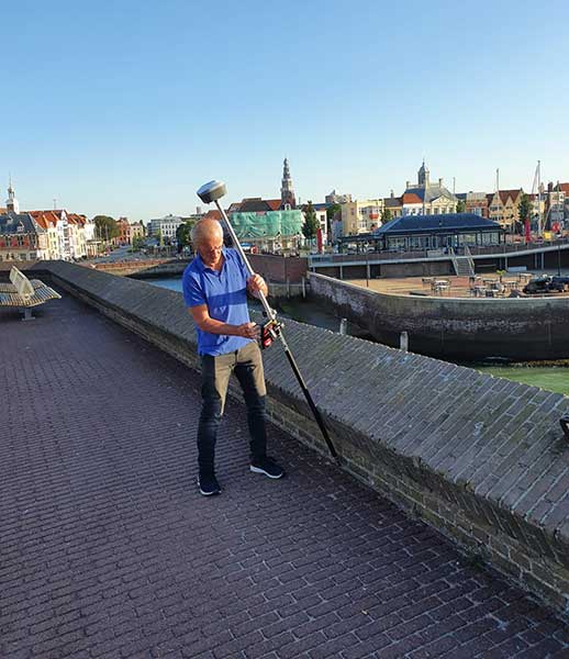
    Total-Station Pole

    Provides tilt-compensation for surveyors

    Photo: Leica Geosystems
    Photo: Leica Geosystems

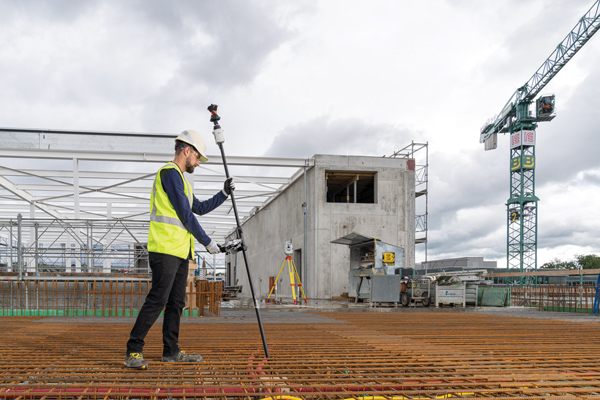
    The Leica AP20 AutoPole provides tilt compensation, automatic pole-height readings and unique target identification for automated total stations. It combines an intelligent sensor module with the AP Reflector Pole and operates with existing Leica Geosystems’ automated total stations to create a solution for autonomous workflows. Tilt compensation decreases measurement time and increases flexibility and safety on site by enabling measurement of points in inaccessible or risky locations. By updating the pole height automatically in the field software, the system ensures that the height on record is always correct.

    Leica Geosystems, leica-geosystems.com


    MAPPING

    Data Management Platform

    Provides validation in the cloud

    Photo: NV5 Geospatial
    Photo: NV5 Geospatial

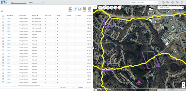
    INSITE Data Reviewer moves geospatial data validation to the cloud, giving key stakeholders the ability to collaborate in real time. The third module in the INSITE Lifecycle suite of products, INSITE Data Reviewer provides reviewers real-time access to aerial imagery, lidar data and geographic information system (GIS) layers via the cloud to standardize quality control. This increases data validation speed and reduces costs of geospatial projects. The INSITE Lifecycle suite combines Project Tracker, Data Delivery and Data Reviewer modules through which users can see their projects executed on a map, from data acquisition through processing.

    NV5 Geospatial, nv5geospatial.com

    Android Mapping

    Asset locations can be captured from a distance

    Photo: Eos Positioning Systems
    Photo: Eos Positioning Systems

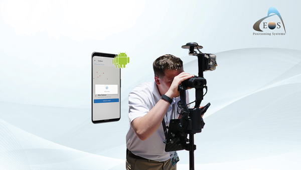
    Eos Laser Mapping for ArcGIS is now available on Android devices. It allows mobile crews to capture high-accuracy laser offsets directly into ArcGIS Field Maps with Arrow Series GNSS receivers. The solution combines technology from geographic information system (GIS) provider Esri, laser rangefinders from Laser Tech, and Eos’ own Arrow Series GNSS receivers. The release supports three workflows: standard laser offset (range-azimuth), range-range (range-intersect) and range-backsight (a total station-like method).

    Eos Positioning Systems, eos-gnss.com


    OEM

    Accelerometer

    For navigation systems on land and at sea

    Photo: Honeywell
    Photo: Honeywell

    The MV60 micro-electromechanical system (MEMS) accelerometer delivers high performance and reliability in a small, rugged and low-cost package. The MV60 measures the acceleration experienced by an object during movement and is designed for use in inertial measurement units and navigation systems deployed on land, air and sea vehicles to measure velocity. It has a compact footprint of 1.2 square inches and shock survivability of up to 5,000 g. It also offers bandwidth of greater than 300 Hz — important for environmentally demanding missions.

    Honeywell, honeywell.com

    CLAS Support

    Receivers support Japan’s cm-level augmentation service

    Photo: Septentrio
    Photo: Septentrio

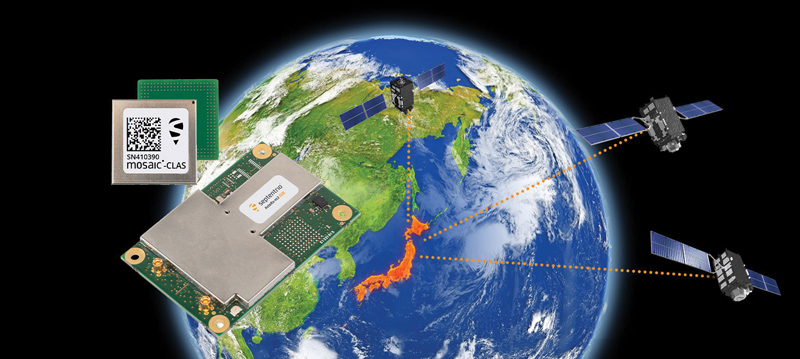
    Three multi-frequency GNSS receivers now support the Centimeter-Level Augmentation Service (CLAS), receiving the L6 signal that transmits high-accuracy corrections from Japan’s QZSS constellation. The mosaic-CLAS receiver is in a small form-factor suitable for high-volume industrial applications. The AsteRx-m3 CLAS OEM board combines PPP-RTK CLAS with dual-antenna heading functionality. The AsteRx SB3 CLAS features a ruggedized IP68 enclosure to protect it in harsh environments.

    Septentrio, septentrio.com


    UAV

    Long-Endurance Prototype

    Designed to check basic aircraft systems

    Photo: UAVOS
    Photo: UAVOS

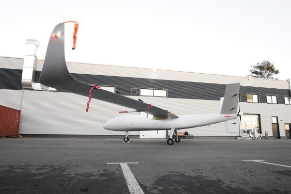
    The S1-V300 medium-altitude long-endurance (MALE) unmanned aerial system (UAS) prototype is based on the Saker MALE UAS design that achieved operational capability in 2020. The prototype features a new design and a more powerful heavy fuel engine with 260 HP, offering greater speed, payload and endurance of 28 hours with a range of 4,020 km. The aircraft features unique UAVOS avionics solutions and a redundant flight control system that will enable complex missions, including overland and maritime intelligence, surveillance and reconnaissance (ISR) missions. The improved S1-V300 prototype is equipped with both line-of-sight and beyond-visual-line-of-sight (BVLOS) datalink systems for over-the-horizon operations. It can be integrated with multiple ISR sensors, including electro-optical infrared cameras and a synthetic aperture radar that offers all-weather, day/night performance for a wide-area search capability.

    UAVOS, uavos.com

    Professional UAVs

    Dragonfish Lite and Pro now available in United States

    Photo: Autel Robotics
    Photo: Autel Robotics

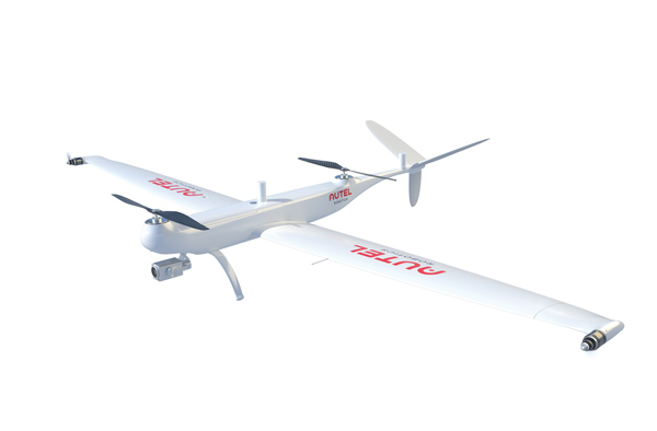
    The rugged Dragonfish UAVs are capable of vertical takeoff and landing (VTOL) with both multi-rotor and winged flight, with an endurance of up to 180 minutes. They are suitable for professional applications such as energy, mining, defense and surveillance. Maximum winged flight speed is 30 m/s (108 km/h, 67 mph), and maximum video transmission range is 30 km (18.6 miles) with a base station. The aircraft can make a smart decision to either land or return to base in case of issues such as loss of GPS signal, loss of operator communications, or low battery power. The tilt-rotor system will automatically transition to multi-rotor mode if adverse conditions cause fixed-winged flight to stall or become unsustainable. The Dragonfish battery, barometer, positioning system, compass and inertial measurement unit all have backup modules to ensure flight safety.

    Autel Robotics, autelrobotics.com


    TRANSPORTATION

    Video Telematics

    Enhanced experience for fleet operators

    Photo: Geotab
    Photo: Geotab

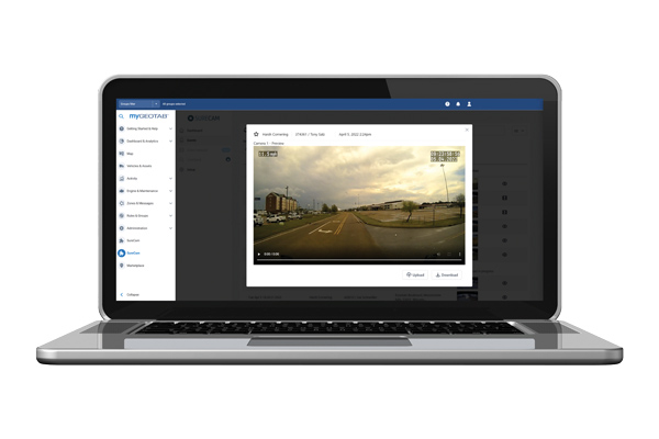
    The SureCam connected dash camera system now features a method for capturing video footage from SureCam cameras using Geotab’s telematics device and rule-based system. This results in a seamless display of video within the MyGeotab platform. The enhanced SureCam fleet video solution leverages Geotab’s numerous data-based rules, such as improper seat belt usage and speeding. It also uses G-force triggered alerts that detect unsafe driving behaviors and automatically captures video footage that can be reviewed later. A new Video Request feature in GeoTab enables fleet managers to preview and download additional SureCam video, enabling them to investigate call-ins and other minor incidents that may not have been triggered by an event-based rule.

    Geotab, geotab.com; SureCam, surecam.com

    Asset Tracker

    Module enables NB-IoT on-the-fly

    Photo: Telit
    Photo: Telit

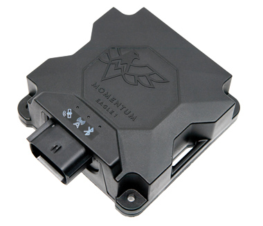
    Momentum IoT’s long-life Eagle 1 tracker works without external power for more than six months after a single charge. The device switches on-the-fly between narrowband internet of things (NB-IoT) and LTE Cat-M. The Eagle 1 leverages Telit’s dual-mode ME310G1 module, which delivers low power consumption in a small footprint. The Eagle 1 detects movement with a built-in accelerometer. Using movement and signals from its GPS receiver to determine vehicle trip starts and stops, the device can go into hibernation mode during periods when the vehicle is not in use, further reducing power consumption. Applications include garbage and storage bins, portable toilets, roll-off containers, message-boards, coolers, and other equipment typically stationed in non-powered, remote places for extended periods.

    Momentum IoT, momentumiot.com; Telit, telit.com

  • Raytheon to continue supporting US Air Force geospatial intelligence

    Raytheon to continue supporting US Air Force geospatial intelligence

    An MQ-9 Reaper on patrol. (Photo: Lt. Col. Leslie Pratt)
    An MQ-9 Reaper on patrol. (Photo: Lt. Col. Leslie Pratt)

    Contract to provide geospatial intelligence, infrastructure support and training for the Air Force Distributed Common Ground System

    Raytheon Intelligence & Space (RI&S), a Raytheon Technologies business, has been awarded a five-year indefinite delivery, indefinite quantity contract to continue geospatial intelligence (GEOINT) system mission support and training for the U.S. Air Force’s Distributed Common Ground System (DCGS).

    Under the DCGS GEOINT Field Support contract, RI&S will provide mission support and engineering services for the current DCGS weapon-system baseline as well as partnering with the Air Force to facilitate the transition to an open architecture.

    Open architecture will enable DCGS to more readily integrate data from the intelligence community and commercial providers, with the goal of using artificial intelligence to create multi-intelligence analysis.

    DCGS draws in data from airborne sensors aboard the RQ-4 Global Hawk, Mq-1 Predator, MQ-9 Reaper and other intelligence, surveillance and reconnaissance platforms all over the globe.

    Under the contract, RI&S will leverage its mission domain knowledge to ensure high mission availability to support end-to-end operations, from mission planning for an airborne sensor to data collection, processing and data discoverability for the DCGS Analysis Exploitation Teams in support of theater and National Command Authority.

  • Topcon represents construction industry in CampusOS 5G research project

    Topcon represents construction industry in CampusOS 5G research project

    Photo: Topcon
    Photo: Topcon

    Topcon Positioning Germany is one of 22 partners involved in CampusOS, a research project with the goal of developing a modular ecosystem for open 5G campus networks based on open radio technologies and interoperable network components.

    As part of the German technology program “Campus networks based on 5G communication technologies,” innovative solutions for open 5G networks are being developed and tested in conjunction with the German Federal Ministry for Economic Affairs and Climate Protection. The program was launched at the beginning of 2022 and will run through 2025.

    The use of artificial intelligence in the operation of autonomous plants and construction machinery requires the highest level of digital sovereignty. If Construction 4.0, including far-reaching automation, is to become a reality in Germany and the rest of the world, the processes of such data-driven solutions must run reliably, quickly and autonomously.

    The German Federal Ministry for Economic Affairs and Climate Protection is providing €18.1 million in funding for the technology program over the next three years, which will cost €33 million total. The Fraunhofer Institutes FOKUS and HHI are coordinating the project. 22 partners from industry and research are involved, including Deutsche Telekom, Siemens, Robert Bosch and more.

    “To enable companies to operate their own campus networks, certain requirements must be met; from standardized technology building blocks to network structures,” explained Ulrich Hermanski, chief marketing officer of the Topcon Positioning Group. “As the sole representative of the construction industry, Topcon will test the technologies on reference test sites and, therefore, will help shape the solutions for the future. We look forward to working with our research partners to take the digital construction site to the next level.”

    With this research project, construction companies will one day be able to operate plants and machinery autonomously in open campus networks. This will allow the fluid and uninterrupted monitoring of construction sites in real time, as well as the networking of all sensors and construction machines in use on construction sites.

    Autonomous from public networks, 5G technology guarantees seamless machine-to-machine communication and transmits data 10 times faster than 4G.

  • CACI to demonstrate time-based navigation to support GPS

    CACI to demonstrate time-based navigation to support GPS

    Artist's impression of the CACI/York Space DemoSat scheduled to launch in January 2023. (Credit: CACI)
    Artist’s impression of the CACI/York Space DemoSat scheduled to launch in January 2023. (Credit: CACI)

    CACI International, a U.S. defense contractor, plans to demonstrate a supporting navigation technology for military use as part of its DemoSat launch in January 2023.

    CACI will launch two demonstration payloads on a York Space Systems satellite scheduled to fly to low Earth orbit in January aboard the SpaceX Transporter 7 rideshare.

    The payload will contain an alternative positioning, navigation and timing solution that will work in a contested space domain. It is designed to support rather than replace GPS.

    The technology is two-way time transfer and clock modeling technology. Two-way time transfer has been used for years on the ground, but in this case will be used in space. The low size, weight and power (SWaP) space-based PNT is expected to significantly improve multi-platform remote sensing.

    If the experiment is successful, CACI plans to offer the two-way time transfer PNT service to the military and other government agencies.

    CACI has completed the critical design review for the DemoSat. CACI and its partner York Space Systems will also demonstrate a tactical intelligence, surveillance and reconnaissance (TacISR) payload. The TacISR payload identifies and captures key signals of interest and operates with CACI’s Beast ground receiver to demonstrate real-time radiofrequency geolocation for deployed U.S. forces.

    “CACI expertise, systems, and technology help our customers maintain dominance in the increasingly contested space environment,” said Mike Hale, executive vice president of CACI’s Advanced Solutions Group. “We are very proud that CACI is launching a DemoSat payload into orbit – distinguishing our mission technology and transformative solutions for customer success.”

  • Tersus GNSS releases white paper on ExtremeRTK Technology

    Tersus GNSS releases white paper on ExtremeRTK Technology

    Photo: Tersus GNSS
    Photo: Tersus GNSS

    Tersus GNSS has released a white paper on ExtremeRTK Technology. According to the company, the white paper demonstrates how ExtremeRTK Technology delivers excellent performance in all manner of surveying scenarios and describes its impressive compensated results when performing tilt surveys — even tilt at angles greater than 90°.

    As a professional real-time kinematic (RTK) developer and manufacturer, Tersus believes the stability and accuracy of RTK are the cornerstones of RTK measurement.

    According to the paper, “ExtremeRTK integrates the receiver’s hardware, high-precision baseband IC [integrated circuit], RTK engine, GNSS/INS coupling algorithm, etc. It enables unprecedented performance stability in challenging environments and prevents occurrences of occasional RTK positioning outliers.”

    Tersus starts from scratch — engineering each element from its foundation in the physics of GNSS. From signal capture and baseband tracking engine to position-velocity-time (PVT) results and the overall algorithm of RTK, Tersus completes all algorithm logic independently.

    The white paper discusses:

    • signal tracking and multipath mitigation capabilities
    • fix speed in open-sky and challenging environments
    • accuracy when performing RTK control/detail point/continuous point surveys
    • GNSS/INS tilt compensation.

    Test results described indicate the remarkable performance of ExtremeRTK technology in RTK initialization, accuracy and tilt compensation. Based on ExtremeRTK, Tersus will continue to invest in the further development of RTK receivers by adding photogrammetry, laser scanning and more.

    Meanwhile, Tersus will also focus research and development on professional industry software, the integration of resources in data management, and big-data applications so it can provide users with additional professional services.

    To download the white paper, visit the Tersus GNSS site.

  • Keeping up with jamming, spoofing threats

    Keeping up with jamming, spoofing threats

    Hexagon | NovAtel's GAJT-710ML installed on a U.S. Army vehicle. Photo: U.S. Army Futures Command
    Hexagon | NovAtel’s GAJT-710ML installed on a U.S. Army vehicle. Photo: U.S. Army Futures Command

    We asked Dean Kemp, Ph.D., director of Marketing, Aerospace and Defense for Hexagon’s Autonomy & Positioning division, a few questions.

    How do jamming and spoofing threats change?

    Jamming and spoofing methods change as new interference-causing technologies become available. As such, it’s vital for us to continuously evaluate potential sources of threats and provide the highest possible level of resiliency to interference in our solutions.

    Have new threats emerged in the past six weeks in connection with Russia’s invasion of Ukraine?

    Evidence is emerging that electronic-warfare systems capable of high-power jamming and spoofing across wide areas are being used within Ukraine. Fortunately, there have been no known impacts on allied forces. However, knowing that the technology is in place and in use highlights the importance of assured positioning, navigation and timing (APNT) and our contribution to building resiliency in allied forces’ equipment against the potentially destabilizing effects of jamming and spoofing.

    How do you define APNT?

    We use APNT to describe measurements that are always accurate, available and reliable. Our anti-jamming, anti-spoofing and other resilience-building capabilities provide trusted and available PNT information at the level of accuracy requested.

    When did you introduce GPS Anti-Jam Technology (GAJT)? How do you define it?

    GAJT was introduced in 2011 and is our leading APNT solution. GAJT units are utilized worldwide across land, sea and air, with rapid deployment supported by commercial off-the-shelf solutions and short lead times. GAJT provides jamming protection of satellite-based navigation and precise timing receivers from intentional jamming and unintentional interference whatever your application. Product variants provide features to best support anti-jamming capabilities for the warfighter, national infrastructure, low-SWaP platforms and other mission-critical applications.

    What are the key differences between the GAJT-710ML, the GAJT-710MS and the GAJT-410MS?

    The GAJT-710 is designed for land vehicles (ML variant) and marine vessel platforms (MS variant) with up to six simultaneous nulls to protect against jamming signals and interference. The next generation of GAJT-710 includes jammer direction-finding and a silent mode to reduce its thermal signature. The GAJT-410 maintains the high levels of interference-rejection performance in the 710 but in a lower size, weight and power (SWaP) design, with three simultaneous nulls, for both land and marine variants. It also utilizes a single RF cable to provide clean power, data and protected GPS signal. The GAJT-410 enables APNT while also reducing the need for platform modifications or armor penetration.

    The GAJT-AE extends jamming and interference protection to unmanned and autonomous applications. Using an external CRPA antenna, the GAJT-AE offers flexibility of integration into space-constrained platforms.

    Is the GAJT-AE-N Anti-Jam Antenna receiver-agnostic?

    We designed our GAJT product line to be receiver-agnostic and compatible with legacy and modern GNSS receivers. This flexibility results in GAJT being ideal for civil and military applications, including SAASM and M-code systems.

    How does your GNSS Resilience and Integrity Technology (GRIT, launched in 2020 November) relate to your GAJT antennas?

    GRIT is a firmware suite for our OEM7 receivers that expands their situational awareness and interference mitigation tools. GRIT includes our Interference Toolkit (ITK) along with spoofing detection to identify when your GNSS signal may be under threat. It also empowers the user to develop interference location algorithms through time-tagged snapshots of data samples to characterize the RF environment around your operations. GRIT, alongside GAJT, forms the foundation of our APNT strategy in providing accurate and always-available PNT.

    Do you have any recent contracts with the U.S. Department of Defense or the militaries of other NATO countries to supply GAJT antennas?

    Our GAJT product portfolio has been sold in large quantities to military and civil organizations for many years, successfully proving itself in the field. In 2020, we achieved a milestone of more than several thousand units shipped worldwide, making it one of Hexagon | NovAtel’s more successful years.

  • Tiny clock meets big challenges

    Tiny clock meets big challenges

    chip-scale atomic clocks can supplement GNSS receivers to provide accurate and reliable time in GNSS-challenged environments. Photo: Microchip Technology
    Chip-scale atomic clocks can supplement GNSS receivers to provide accurate and reliable time in GNSS-challenged environments. Photo: Microchip Technology

    Accurate and reliable time is just as important as accurate and reliable location for a wide range of military and civilian applications — and GNSS receivers cannot provide either one when they are jammed. For timing, one solution is to supplement GNSS receivers with a miniature atomic clock. We asked Microchip Technology a few questions about their chip-scale atomic clock (CSAC) and Stewart Hampton, the company’s senior product line manager, responded.

    How long was your SA65 CSAC in development before you announced it in August 2021? Typically, how often do you launch a new CSAC?

    CSAC development started in 2001 under a contract from DARPA with Draper and Sandia laboratories. CSAC was first introduced to the commercial marketplace in 2011, and in 2016 we released an improved product design with an operating temperature range of –10 C° to +70 C°. Last year we released our CSAC SA65 with a wider operating temperature range, faster warm-up and improved frequency stability aimed at the defense and industrial marketplace. So, it has been about five years between major CSAC releases, but that may not be indicative of future products because we have also introduced specialized CSAC versions, such as the Low Noise CSAC (LNCSAC) in 2014 and the only commercially available radiation-tolerant CSAC (Space CSAC) in 2018.

    What is the CSAC SA65’s drift rate?

    Its typical drift rate is specified at <9 × 10⁻¹⁰ per month. Another key specification, particularly for many portable military applications, is total sensitivity of frequency to temperature (tempco) over a specified range. For the CSAC SA65, that specification is ±3 × 10⁻¹⁰ over the entire operating temperature range of –40 C° to +80 C °.

    What are a few specific military use cases?

    CSAC is designed into multiple military programs and used in a wide variety of military applications, particularly in GNSS-denied environments — including assured positioning, navigation and timing (APNT) modules, underwater unmanned and autonomous vehicles, software-defined radios, man-portable transceiver-based military communications, vehicle management computers, airborne reconnaissance/UAVs and GNSS-disciplined oscillators. It is also used in command, control, communications, computers, cyber, intelligence, surveillance and reconnaissance (C5ISR). The space CSAC variant is commonly used on low-Earth-orbit space defense payloads supporting such applications as low-latency communications networks, RF geolocation (geointelligence, or GEOINT), optical time transfer, alternative PNT satellites and Earth observation.

  • Realism in chamber-based CRPA testing

    Realism in chamber-based CRPA testing

    Spirent Federal Systems, a PNT simulation company, offers its government customers and contractors a unique solution for anechoic-chamber-based CRPA testing: a patented “zoned chamber” approach using multi-output, multi-constellation GNSS signal simulators to emulate the movement of satellites in orbit.

    To address the limits of a standard anechoic chamber, Spirent has created independent zones configured to represent the real-world sky view, using genuine constellations and improved satellite azimuth and elevation arrival angles. Test scenarios can be multi-constellation and multi-frequency with customizable time, date and duration — now lasting hours instead of minutes.

    Because scenarios are valid for longer time periods without sacrificing realism, the zoned chamber is effective for validating all aspects of the CRPA system including beamforming, null steering and space-frequency adaptive processing/space-time adaptive processing (SFAP/STAP). CRPA systems with inertial sensors can be tested with static and dynamic scenarios using a positioner within the chamber.

    Additionally, to account for multipath and signal obscuration, Spirent has integrated a 3D environment modeling tool which generates all the variables of a multipath-rich environment in real time, including ground reflection. Interference sources such as jammers and spoofers can be added anywhere in the chamber and concurrently simulated with the GNSS signals. Authorized users can also test classified RF signals such as MNSA M-code and Y-code.

    “Spirent Federal’s goal is to get new technologies to U.S. warfighters at a speed that outpaces near-peer threats,” said Jeff Martin, vice president of Sales. “The realism of our patented zoned chamber allows advanced CRPA systems to be deployed faster with confidence they will perform in GPS-contested environments.”

    Illustration of a simulated test environment incorporating GNSS, multipath and jamming in a Spirent zoned chamber. (Image: Spirent Federal)
    Illustration of a simulated test environment incorporating GNSS, multipath and jamming in a Spirent zoned chamber. (Image: Spirent Federal)
  • The transition to M-code begins

    The transition to M-code begins

    BAE Systems has produced more than one and a half million military GPS receivers. The company is transitioning receiver designs to use the modernized military code (M-code) signal for added resiliency in RF-challenged environments. We asked Luke Bishop, director and product line engineering lead for the company’s Navigation & Sensor Systems, a few questions.

    BAE Systems’ MPE-M provide the benefit of M-Code operation in a challenged RF environment. Image: BAE Systems
    BAE Systems’ MPE-M provides the benefit of M-Code operation in a challenged RF environment. Image: BAE Systems

    Why transition to M-code?

    There are three key reasons for users to transition to M-code as supported by Military GPS User Equipment (MGUE). First, MGUE provide U.S. forces and our allies with enhanced PNT capabilities while improving resistance to threats, such as accidental and intentional jamming. Compared to the current P(Y)-code signal specs, M-code signals are stronger. Second, MGUE provides improved resistance to spoofing. Third, MGUE is field programmable, enabling updates to accommodate future enhancements to the GPS enterprise, such as regional military protection (RMP).

    Which user equipment is transitioning to M-code?

    Successful MGUE Inc 1 prototype development is being leveraged into a full portfolio of weapons, ground and aviation/maritime M-code GPS receivers. Our first production M-code receiver, MPE-M, achieved production deliveries in CY2021, with more than 1,000 delivered. Additional M-code GPS form factors are under development.

    We are also underway with the Foreign Military Sales (FMS) M-code program with MPE-M.

    How is the transition to M-code proceeding?

    As indicated by the January 2021 GAO report (GAO-21-145), M-code-capable user equipment is in the initial stages of Department of Defense (DOD) fielding for select weapon systems. Also noted by the GAO report, the DOD has conducted bulk purchases of the Increment 1 ASICs [application-specific integrated circuits] to ensure that “sufficient supplies of [them] are on hand for future integration into M-code card …based on estimated need through 2028.” We are at the beginning of M-code (MGUE). Time and the market will tell what ultimately happens.

    Which of your receivers operate with an anti-jam (AJ) antenna?

    BAE Systems’ receivers support both stand-alone AJ and integrated AJ. Receivers with integrated AJ include the NavFire-M, NavStorm-M and SABR-M receivers supporting high-dynamic weapons applications. Receivers directly supporting external AJ via a digital beamforming interface include the MPE-M and AMR. Our external AJ DIGAR offering provides exceptional performance for many stakeholders.

    Do you use advanced signal simulation equipment?

    We integrate Spirent Federal and other signal simulators in both our test and development environments, where modeled RF signals are coordinated with other sensor measurements and host vehicle messages for high-fidelity hardware-in-the-loop test cases. Our engineers create hundreds of test cases and scripted test procedures to exercise our products under all required conditions. These simulations allow us to run thousands of trials to qualify and validate performance of our products in extreme scenarios.

    Photo:
    BAE Systems’ hardware-in-the-loop simulation environments build upon Spirent Federal signal generators to test products under extreme dynamic and threat environments. (Photo: Spirent Federal)
  • New APNT in an old box

    New APNT in an old box

    Leonardo DRS’ A-PNT Converged Computer – Embedded & Scalable (AC²ES) adds capabilities to its widely used DDUx. Photo: Leonardo DRS
    Leonardo DRS’ A-PNT Converged Computer – Embedded & Scalable (AC²ES) adds capabilities to its widely used DDUx. Photo: Leonardo DRS

    To help counter attacks that degrade GNSS capability on combat vehicles, Leonardo DRS developed a modified data-distribution unit computer, the DDUx II, with an embedded assured positioning, navigation and timing (APNT) capability the company calls Assured Positioning, Navigation and Timing Converged Computer Embedded & Scalable (AC²ES). It augments standard military GPS PNT sources with technologies such as anti-jam, anti-spoof, M-code receivers, additional RF sources, vehicle infrared (IR) sensor vision navigation, wheel rotation and inertial measurement units (IMUs). It also offers a choice of multiple timing holdup modules that increase accuracy proportionately with cost.

    The DDUx II and military variants, fielded by the U.S. Army and Marine Corps, allow for integration of APNT functionality with the Battle Management System (BMS). It can provide APNT distribution to all other devices needing PNT within the vehicle without adding to its size, weight and power (SWAP).

    Following a five-year development program, Leonardo DRS launched the AC²ES in September 2021 as a commercial option while continuing discussions with the U.S. Army and Marine Corps, which have not yet adopted it. “We have tested it,” said Mike Stucki, business development manager for the company’s land electronics division. “We have gone to Army jamming and testing events. We have performance and results. However, it has not been officially tested under the Army or Marines programs, with which we are moving forward this year.”

    Leonardo DRS wants to offer the armed services the additional components they need to achieve APNT “and not require them to buy anything they don’t need or want,” Stucki said. Those additional components include multiple GNSS receivers for timing and a low-end internal IMU to provide continuous navigation in case GNSS is disrupted. All these components fit directly into the existing DRS hardware. Under the Mounted Family of Computer Systems (MFoCS) program alone, the Army has fielded more than 100,000 DDUx units. Some vehicles already have high-end INS, wheel encoders, and other sensors, and MFoCS can ingest their data.

    Navigating with Infrared

    For vision navigation, Leonardo DRS uses software developed by its partner Leidos that ingests data from existing hardware on the vehicles, many of which already have IR cameras. In a GNSS-denied environment, this enables the system to navigate by matching what the IR camera sees to an imagery database. Leidos’ software is based on work it began in 2011 with the DARPA All-Source Positioning and Navigation (ASPN) program.

    “Leidos developed algorithms that use these other sensor inputs in the sensor-fusion engine to provide more accurate absolute positioning in a completely RF-denied environment,” said Kevin Betts, PNT director for Leidos. “We take the live images from the vehicle’s existing IR camera and match them to a satellite-derived model of the environment. When the images match, we have an absolute position update that we can provide to the navigation filter.”

    MFoCS “is the heart that runs the Blue Force tracker system that the soldiers use,” said Bart Blanchard, director of advanced programs at Leonardo DRS. “We’ve added the APNT components inside that box. They’re leveraging the hardware that they already own. It’s a very cost-effective solution.”

  • Seen & Heard: Defending Ukraine, Olympic prep

    Seen & Heard: Defending Ukraine, Olympic prep

    “Seen & Heard” is a monthly feature of GPS World magazine, traveling the world to capture interesting and unusual news stories involving the GNSS/PNT industry.


    Image: Stadium, OnePlan/Paris 2024 Organizing Committee for the Olympic and Paralympic Games
    Image: Stadium, OnePlan/Paris 2024 Organizing Committee for the Olympic and Paralympic Games

    PARIS OLYMPICS GET DIGITAL TWIN

    In an Olympic first, the 2024 Olympics and Paralympics in Paris will receive a digital twin for planning and collaboration. OnePlan’s GIS Mapping and Venue Twin software will be used to create a 3D map of each sports venue and surrounding areas to help event planners, partners and suppliers collaborate in real time. They will be able to see spaces and capacities at any angle, in any light, in any weather condition at any time. Infrastructure such as barriers, fencing, vehicles, teams, volunteers and broadcast cameras can be positioned in the twin. Organizers can plan for any scenario, improving efficiency and safety, as well as take the needs of the disabled into account.


    Photo: DeepRoute.ai
    Photo: DeepRoute.ai

    HOW WILL THEY SPEND THEIR TIPS?

    A fleet of 30 “Robotaxis” – Level 4 autonomous cars – will hit the streets in Shenzhen, China, to showcase an autonomous solution by DeepRoute.ai. The Robotaxis – SAIC Motor SUVs outfitted with DeepRoute.ai’s Driver 2.0 – preview plans for mass production of autonomous vehicles in 2024, including for purchase by consumers. Autonomous cars are classified in five levels, with Level 5 the highest. A human driver can take over a Level 4 vehicle. Level 4 consumer vehicles on the road also gather data that is used to further improve Level 4 autonomous driving.


    Switchblade 600. (Photo: AeroVironment)
    Switchblade 600. (Photo: AeroVironment)

    GHOST DRONES TO HELP UKRAINE

    The United States has committed more than $4 billion in security assistance to Ukraine, including on April 21 more than 121 Phoenix Ghost tactical unmanned aerial systems. The drones were rapidly developed by the Air Force specifically to meet Ukraine’s requirements. The Ghost drones are manufactured by Aevex Aerospace and have similar capabilities to the single-use “kamikaze” Switchblade UAS from AeroVironment, which also are being provided to Ukraine forces. The Switchblade 600 shown here is designed to destroy tanks and other armored vehicles. It weighs slightly more than 120 pounds and has a range of more than 40 miles.


    Photo: NASA
    Photo: NASA/JPL-Caltech/University of Arizona/USGS

    OUR MARTIAN ADVENTURE

    NASA’s Ingenuity UAV has now spent more than a year on the surface of Mars, with 21 flights under its belt. It is now scouting potential routes for its companion, the Perseverence rover. Most recently, Ingenuity traveled to the Séítah region to examine an extinct river delta, covering 1,150 feet and navigating around a large hill, to help determine the best route into the delta. The NASA team continues to gently push the drone’s capabilities to better understand improvements that can be applied to future Mars UAV designs.

  • Downed Russian jets found with GPS receivers taped inside

    Downed Russian jets found with GPS receivers taped inside

    Russian fighter jets in better times. (Photo: Aterrassi/iStock/Getty Images Plus/Getty Images
    Russian fighter jets in better times. (Photo: Aterrassi/iStock/Getty Images Plus/Getty Images

    Russian jets using GPS receivers, while ground vehicles use paper maps

    GPS receivers have been found taped to the dashboards of Russian jets downed in Ukraine, according to a report from Express. The Express received the information from Ben Wallace, United Kingdom defense secretary, who mentioned it in a speech at the National Army Museum.

    The GPS receivers were found taped to the dashboards of Russian SU-34s because of “the poor quality of their own systems,” he said. It is unclear whether he was referring to the Russian GLONASS satellite navigation system or the navigation systems aboard the SU-34 jets, but most likely the latter. Lack of maintenance and modernization of Russian military equipment has been obvious since the beginning of Russia’s invasion of Ukraine.

    As for navigation on the ground, many vehicles were found with paper maps from the 1980s, Wallace said.

    Russian ground vehicles also lack situational awareness and digital battle management, he said, while the large amount of footage from Ukrainian drones points to a lack of wider air defense, including counter-UAV systems.

    In a different news story from the war, Ukraine may be receiving Raytheon-built GPS-guided artillery rounds.