What technical and business challenges are getting your attention this year?
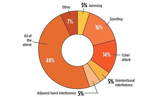
What are the most important benefits of, and the key challenges posed by, new modernized GNSS signals? How are you driving business in today’s economy?
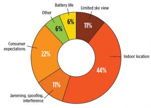
What issues are you concerned about? What solutions hold the most promise for positioning, navigation and timing (PNT) in challenged and indoor environments — regardless of which technology provides them?
We want to know, and so does the rest of the industry.
GPS World is asking PNT professionals about the developing technology frontiers, the state of their business, the economic climate for products and services, driving market factors, the effects of jamming, the Issue of the Year — and more! Please give us your opinions in the 2019 State of the Industry survey. It should take less than 10 minutes, and your responses are confidential.
A handful of lucky participants drawn at random will win TWO $100 gift cards good (virtually) anywhere.
Complete the survey by June 30. Then look for a complete report of our findings in the September issue of GPS World.
Thank you for taking the time to share your feedback and help us improve our magazine content, industry awareness — and your own business!
While asking questions that have appeared in past State of the Industry surveys, to reveal industry changes that have taken place over the last five years, the 2019 Survey presents these new issues for your consideration:
• With multiple constellations, signals and services now beginning to emerge, what are the challenges to keeping open and seamless access to these in the international marketplace ?
• Among the many benefits of modernized signals, which is the most important in your field of work?
• Among the key challenges in utilizing modernized signals, which gets most of your attention?
The question above offers such answer choices as: increases die size without ability to increase chip cost; longer code sequences are difficult to acquire; increases RAM/ROM; increases number of RF channels; increases number of digital channels; higher CPU processing required; and software complexity with many signal types.
What one word would you use to describe your company’s No. 1 opportunity to grow in 2020?
What one word would you use to describe your company’s No. 1 obstacle to growth in 2020?
Overall, the 2019 Survey covers such topics as:
Technology Trends. PNT is rapidly diversifying among a number of complementary technologies, as GNSS looks to inertial, lidar, laser, cellular, WiFi and other beacons, signals of opportunity, low-Earth orbit satellite constellations and more. Different market sectors have, naturally, different requirements, and these lead to different integration combinations. Where do you see the most promise?
The Global Economy and how it affects business in your sector. Customers’ availability of capital to invest is top-of-mind for most industry professionals, whether designers, manufacturers, integrators, suppliers/dealers, or end users.
Industry Confidence in the road ahead. Sound business navigation requires a fluid, responsive combination of technology, capital, investment, and often most important, human capital. .
Issues of Concern. To what extent do industry leaders take into account the following as well as further factors?
Pricing and competitive issues;
GNSS jamming, spoofing, other RF interference;
Developing compatibility and interoperability of GNSS: GPS, GLONASS, BeiDou, Galileo;
Advantages and drawbacks of other positioning and navigation technologies.
The survey report, complete with insightful articles and infographics, will appear in the September issue. Look for it!
Abom, a company that designs sophisticated commercial goggles, has launched new augmented reality (AR) goggles.
Designed for safety, industrial and military markets, Abom’s P3 augmented reality goggles feature accurate tracking of orientation, velocity and positioning using IMU/GPS-GNSS/INS receiver capability.
Other features include 3D spatial mapping and tracking, integrated VX Inc. CNED display technology, and an array of integrated image sensors and advanced embedded electronics. The goggles’ stereoscopic dual displays have an ultra-high-brightness output with adjustable control and 1080p output.
The goggles are optimized with a military-ballistics-rated lens (MIL-PRF 32432A) that complies with the Military Compliance Eye Protection (MCEP) program, meeting many challenging elements of the U.S. Army’s IVAS specification (HUD 3.0).
For industrial applications, the P3 also meets ANSI Z87.1+ high-mass impact rating and IP-55 ingress protection against water and dust, which opens the door for supporting National Safety Council technology initiatives and requirements for meeting extreme IP-67 rating compliance.
The P3 goggles are field-use ready and designed for extreme environmental durability and cold-weather climate conditions where demanding ruggedized performance is critical. It has advanced thermal image sensors, and embedded within the Goggle Chassis is an ultra-high-performance depth camera supported by two infrared cameras optimized for low-light conditions up to 10 meters.
The goggles incorporate Abom’s patented ultra-low power thin-film technology, making it impossible for fog to survive on the inner surface of the eyewear, according to the company.
“Abom’s award-winning heated goggle technology, now military approved, has made integration and optimization with immersive, augmented reality display technology the perfect solution for highly ruggedized extreme use-cases that exceed industry standards for both quality and performance,” said Jack Cornelius, Abom CEO.
“Abom’s development partner for the P3 Goggle, VX Inc., has pushed the limits of mechanical and electrical engineering design performance,” Cornelius said.
Autotalks, a vehicle-to-everything (V2X) communications company, has teamed up with Marben for a live V2X demo based on Marben V2X software running on Autotalks’ chipset.
The first live end-to-end global V2X demo will take place at the Autotalks booth (C198) at TU-Automotive Detroit, being held June 5-6 in Novi, Michigan.
Autotalks has been cooperating for several years with Marben, a global leader in embedded software solutions for the telecommunication and automotive industries. The joint effort led to the successful integration of Marben’s stack and software application on Autotalks chipset using the C-V2X standard.
The Autotalks solution minimizes development, testing and certification efforts for a V2X system to be deployed anywhere, using a software toggle between V2X technologies. This translates into a huge advantage for OEMs and Tier 1 automakers who benefit from the shortest time to market for a global V2X platform.
The chipset isolates V2X from the non-safety domains, thus providing domain separation and security, scalability and ability to optimize the cost structure of telematic control units (TCUs). The isolation of V2X combined with Autotalks’ recognized cyber security technology enables a secure platform.
“Our agility in maturing the C-V2X solution simultaneously with leveraging our V2X ecosystem partners for this purpose has yielded fast results and offers a clear deployment path for OEMs and Tier 1s alike. We appreciate Marben’s long-standing cooperation and are pleased to demonstrate the first end-to-end dual-mode V2X demo with them,” said Yaniv Sulkes, Autotalks’ VP of business development and marketing in North America and Europe.
Global software communications company Marben has developed a complete ready-to-use V2X software solution including security and several applications that are deployed worldwide. The company’s solution significantly increases road safety, optimizes traffic and contributes to greener mobility.
“We are glad to partner with Autotalks, and showcase this first of a kind demonstration, after our straightforward and quick C-V2X integration,” said Devang Naik, director of software engineering.
The live demo can be seen at the Autotalks booth C198 at TU-Automotive Detroit.
With more than 80 percent of the world’s oceans unmapped, the deep ocean is one of the last unknown areas on Earth. On May 31, teams with unique exploration solutions were honored with the Shell Ocean Discovery XPRIZE.
XPRIZE is a global competition to advance ocean technologies for rapid, unmanned and high-resolution ocean exploration and discovery. The teams invented new technologies for rapid, unmanned and high-resolution ocean exploration and discovery.
The results were revealed at an awards ceremony hosted at the Oceanographic Museum of Monaco, part of the Oceanographic Institute, Prince Albert I of Monaco Foundation.
The grand prize winner, receiving a total of $4 million, was GEBCO-NF Alumni, an international team based in the United States, while KUROSHIO, from Japan, claimed $1 million as the runner-up.
GEBCO-NF Alumni was led by Rochelle Wigley, Ph.D., and Yulia Zarayskaya, Ph.D. The 14-nation team integrated existing technologies and ocean-mapping experience with a robust and low-cost unmanned surface vessel, the SeaKIT, along with a novel cloud-based data processing system that allows for rapid seabed visualization, to contribute towards comprehensive mapping of the ocean floor by 2030.
Runner-up was KUROSHIO, from Yokosuka, Japan, led by Takeshi Nakatani, Ph.D. The team integrated technologies from their partners to create a surface vessel and software platform that can operate with different autonomous underwater vessels, which increases the versatility of their technology.
Field Testing. To determine winners, the panel of independent judges reviewed data from field testing conducted in Kalamata, Greece, and Ponce, Puerto Rico. In Kalamata, teams had up to 24 hours to map at least 250 square kilometers of the ocean seafloor at five meters horizontal resolution or higher.
The gold-standard high-resolution baseline maps, against which the team maps were judged, were provided by Ocean Infinity and Fugro, while Esri, the global leader in geographic information system (GIS) software and geodatabase management, donated its ArcGIS Online platform for the teams and judges to use.
NOAA Prize. The $1 million National Oceanic and Atmospheric Administration (NOAA) Bonus Prize went to teams for developing technology that could detect a chemical or biological signal underwater and autonomously track it to its source. The award was split between junior high school team Ocean Quest from San Jose, California, which claimed $800,000 as the winner, and Tampa Deep Sea Xplorers, from Florida, taking $200,000 as runner-up.
Additionally, the judges unanimously recommended a $200,000 Moonshot Award for Team Tao from the United Kingdom for its unique approach to seafloor mapping, even though they did not meet the criteria of the competition.
As part of the total $7 million prize purse, four teams opted to compete for the $1 million NOAA Bonus Prize. In a field test in Ponce, Puerto Rico, teams needed to demonstrate that their technology can “sniff out” a specified object in the ocean by first detecting and then tracing a biological or chemical signal to its source.
The judges determined that no single team was able to trace the signal to its source in the timeframe allowed, so the prize was divided among the two teams that came the closest. In 2018, nine finalist teams were awarded an equal share of the first $1 million of the $7 million prize purse, in recognition of their progress-to-date and to support the teams’ continued technological development.
Seabed 2030 and science fiction. As part of its post-prize impact work, XPRIZE announced a partnership with Seabed 2030, a collaborative project between The Nippon Foundation and The General Bathymetric Chart of the Oceans (GEBCO) to inspire the complete mapping of the world’s ocean by 2030 and to compile all bathymetric data into the freely-available GEBCO Ocean Map.
Additionally, and in anticipation of World Oceans Day on June 8th, XPRIZE will launch a science fiction ocean anthology featuring 19 original short stories and artwork set in a future when technology has helped unlock the secrets of the world’s oceans.
Toyota Research Institute-Advanced Development Inc. (TRI-AD) and Carmera Inc. have joined forces to conduct a proof of concept about developing camera-based automation of high-definition (HD) maps for urban and surface roads.
This is the first step towards realizing TRI-AD’s open software platform concept known as automated mapping platform (AMP) to support the scalability of highly automated driving, by combining data gathered from vehicles of participating companies to generate HD maps.
Automated driving requires highly reliable road information based on HD map data. While the creation of highway HD maps is underway, this coverage represents less than 1% of the worldwide road network.
The next challenge is to create and maintain maps for urban areas and local roads that go beyond the highway road network.
TRI-AD/Carmera mapmaking from vehicle cameras in downtown Tokyo. (Image: Toyota/Carmera)
In this proof of concept, the two companies will place cameras in Toyota test vehicles to collect data over several months from areas of downtown Tokyo. The cameras installed in the test vehicles use Toyota Safety Sense components that Toyota installs on its vehicles globally.
Images and other data gathered from TSS will be processed on Carmera’s real-time platform to automatically generate HD map data.
In addition, by placing commercially available dashcam drive recorders in Toyota test vehicles, the project will demonstrate automated map generation from a broader range of sources that do not have TSS.
This draws upon Carmera’s millions of miles of driving video collected, structured and enriched through safety monitoring partnerships with professional fleets in other complex environments like New York City.
Carmera feature detection image in downtown Tokyo. (Image: Toyota/Carmera)
By combining maps automatically generated via the techniques employed in this project with digital maps available today, it will be possible to provide even more reliable road information to automated vehicles in the future. And by generating HD maps based on data acquired from commercially available vehicles around the world, automated driving can be enabled on all roads.
“Currently automated driving map development relies on highly expensive specialized mapping vehicles deployed in limited numbers, and a lengthy manual process for reliable HD map creation,” said Mandali Khalesi, vice president of automated driving at TRI-AD. “We’re excited to partner with Carmera to automate HD map generation and help enable automated driving mobility for all.”
“Carmera was founded to deploy next-generation street intelligence at low cost, high speed and automotive-grade reliability, in order to democratize autonomous mobility at global scale,” Ro Gupta, CEO at Carmera, said. “We’re excited to collaborate with TRI-AD in putting the flexibility and modularity of our platform to work to build HD maps, beginning with one of the largest and most dynamic urban environments in the world.”
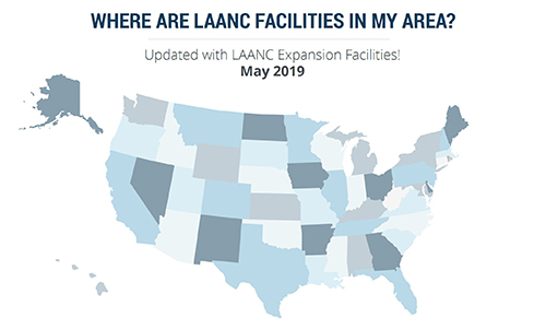
More than 100 control towers and airports have been added to the hundreds of Federal Aviation Administration (FAA) air traffic facilities and airports that currently use the Low Altitude Authorization and Capability (LAANC) system.
LAANC is a collaboration between the FAA and industry that directly supports the safe integration of unmanned aircraft systems (UAS) into the nation’s airspace.
LAANC expedites the time it takes for a drone pilot to receive authorization to fly under 400 feet in controlled airspace. By adding contract towers to the number of LAANC-enabled facilities, drone pilots will have access to more than 400 towers covering nearly 600 airports.
In less than two years, LAANC has provided fast access to controlled airspace for more than 100,000 flights, according to Matt Fanelli, director of strategy at Skyward.
Image: Skyward
“People have been asking the FAA to add more airports and today, 109 contract towers have now been added to LAANC.” Skyward has updated its 2019 LAANC Facilities Guide so that UAV pilots can easily reference airports near them that will be adding this service.
Contract towers are air traffic control towers that are staffed by employees of private companies rather than by FAA employees. LAANC provides air traffic professionals with visibility into where and when authorized drones are flying near airports and helps ensure that everyone can safely operate within the airspace.
The expansion to more than 100 contract towers means the FAA has further increased drone pilots’ access to controlled airspace safely and efficiently.
LAANC is used by commercial pilots who operate under the FAA’s small drone rule (PDF) (Part 107). The FAA is upgrading LAANC to allow recreational flyers to use the system and in the future, recreational flyers will be able to obtain authorization from the FAA to fly in controlled airspace.
For now, recreational flyers who want to operate in controlled airspace may only do so at fixed sites.
Seen & Heard is a monthly feature of GPS World magazine, traveling the world to capture interesting and unusual news stories involving the GPS/GNSS industry.
Photo: Mount Everest/Daniel Prudek/Shutterstock.com
Surveying the highest height
The precise height of Mount Everest — now listed as 29,029 feet, or 8,848 meters — has been contested since the first survey by British officers in 1849.
On January 2020, Nepal plans to end the controversy and declare both snow and rock height of the world’s tallest mountain. This spring a two-member Nepali survey team will summit the mountain with a Trimble R10 GNSS receiver, gifted by New Zealand.
Besides a GNSS survey at the summit, teams will conduct precise leveling, trigonometric leveling and gravity surveys. The GNSS survey will cover 285 points with 12 different observation stations, nine of which are in hills of Sankhuwasava, Bhojpur and Solukhumbu districts.
Photo: e-Golf cars/Volkswagen
Takin’ it to the (Hamburg) streets
Five electric Volkswagen Golfs are now on the streets of Hamburg, Germany, being tested with Level 4 automation.
The cars are designed to handle complex urban traffic patterns without help from drivers, although they must be ready to intervene.
Level 5, the highest category, requires the vehicle to perform all tasks, turning every rider into a passenger.
The cars are driving 1.9 miles (3 km) of urban roads where new signals and traffic management systems have been installed for autonomous driving.
Boeing 787 Dreamliner Hainan airlines/aapsky/Shutterstock.com
GPS Rollover gone wrong
The April 6 GPS Week Number Rollover was supposed to pass without a hitch, with plenty of notice that updates might be required for legacy receivers. Instead, several systems crashed.
In China, as many as 15 Boeing 777s and 787s were grounded pending a GPS update (the receivers gave the date as August 22, 1999.)
In New York City, part of the wireless grid faulted, cutting information feeds to the NYPD (license plate cameras) and remote worksite communications.
In Australia, weather balloons were grounded. In the United States, NOAA autonomous monitoring stations went offline. Fixes for all these systems are underway.
Quectel Wireless Solutions has launched its Proactive Security Solution for Intelligent Driving to enhance driving safety.
The solution supports advanced driver assistance systems (ADAS) and driver monitoring systems (DMS).
The Proactive Security Solution integrates Quectel multi-mode LTE Cat 6 smart modules SC600Y/SC600T and AI algorithm from a third party to realize ADAS and DMS capabilities including monitoring irregular driving behaviors, conducting precise detection of vehicles and traffic signs, sending warnings of potential risks and more.
For ADAS, it can precisely identify and locate vehicles, pedestrians, lanes and traffic signs on the road and will send alerts to drivers if an imminent collision or an unintended lane departure is detected.
Drivers will receive four types of warnings including lane departure warnings (LDW), forward collision warnings (FCW), headway monitoring and warning (HMW) and forward start warning (FSW).
The DMS supports facial recognition and detection, and is able to monitor driver attentiveness and measure eye blinks as well as head movements. Drivers will receive warnings on any distraction such as making or receiving a call, smoking, yawning or looking around. For buses, taxi-hailing services or long-distance passenger vehicles, this solution also allows administrators to know more about their drivers’ states and improve management accordingly.
The driver monitoring system supports facial recognition and detection. (Image: Quectel)
Quectel Proactive Security Solution for Intelligent Driving features a rich set of interfaces and multiple hardware development platforms, designed to cut design-in time and facilitate integration for customers and OEMs.
SC600T/SC600Y is Quectel’s new generation of multi-mode Smart LTE Cat 6 module with built-in Android 9.0 OS. Based on a Qualcomm octa-core and 64-bit high-performance processors with built-in Adreno 506 GPU, SC600T/SC600Y are designed to support high performance, various multimedia features and Quick Charge 3.0 technology. They are designed for both industrial and consumer applications with high data-rate and multimedia functions. Features include:
LTE Cat 6 modem supporting 2x20MHz carrier aggregation, with maximum download speed up to 300 Mbps
Worldwide LTE, UMTS/HSPA+ and GSM/GPRS/EDGE coverage
Dual-band Wi-Fi and Bluetooth
Dual LCDs and dual touch panels for independent display and operation: 1920×1200 @60fps for primary display and 1920×1080 @60fps for secondary display, Wi-Fi display
Support up to four cameras, with two of them working simultaneously
Multi-constellation GNSS receiver available for applications requiring fast and accurate fixes in any environment
Support recording and playback of 4k videos at 30fps@SC600T/ 1080P videos at 60fps@SC600Y
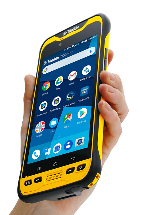
Trimble has introduced the TDC600 handheld, an ultra-rugged, all-in-one smartphone and GNSS data collector for geographic information system (GIS) and field inspection applications.
The next-generation smartphone data collector runs on an Android 8.0 operating system. It has a bright sunlight-readable 6-inch display, 2.2-GHz processor, 4-GB memory and an enhanced capacity all-day battery.
More powerful and with a longer lasting battery than its predecessor, the TDC600 handheld supports the Trimble Catalyst GNSS positioning service that delivers subscription-based accuracy on demand for Android devices.
In addition, the TDC600 can be used with external receivers such as the Trimble R2 and R1 GNSS receivers, and also features a built-in GNSS receiver that supports GPS, GLONASS and BeiDou constellations plus satellite-based augmentation system (SBAS) capabilities for real-time positioning.
The TDC600 is built for GIS users in organizations across a variety of industries —environmental management, utilities and government agencies. With Wi-Fi, Bluetooth 4.1 and 4G LTE cellular connectivity that supports data and voice calls, field workers are able to use the TDC600 as they would any consumer smartphone, communicating between the field and office, sending emails and texting.
Featuring a slim, lightweight and ergonomic pocket-size form factor, the TDC600 fits in a user’s hand with a fitted strap providing extra security. Constructed to meet military (MIL-STD-810G) specifications, the durable design absorbs drops and shocks, and works in harsh weather conditions, without the need for a protective case.
The TDC600 integrates seamlessly with Trimble’s data collection applications —Trimble TerraFlex] software and Trimble Penmap for Android software — as well as third-party apps such as Esri Collector for ArcGIS.
With its Google Mobile Services certification, users can run Google core applications and access apps on the Google Play Store to personalize their device.
“The global mobile workforce is growing, and field personnel are constantly tasked with capturing and computing large amounts of data in more places with greater accuracy, requiring powerful and reliable data collection methods,” said Rachel Blair-Winkler, business area manager for Trimble Mapping & GIS.
“A professional turnkey solution such as the TDC600 handheld running Trimble data collection apps paired with the Trimble Catalyst service fulfills this requirement,” Blair-Winkler said. “Our customers now have a powerful, comprehensive and cost-effective entry-level system to collect and retrieve highly accurate GIS data virtually anywhere in the world.”
NovAtel has added the GAJT-410ML to its GPS Anti-Jam Technology (GAJT) portfolio. Designed specifically for rapid integration into space-constrained military land applications, the easy-to-use system protects GPS-based navigation and precise timing receivers, including M-code, from both intentional and accidental interference, the company said.
The GAJT-410ML is the next evolution of NovAtel’s battle-proven anti-jam technology. It maintains the high levels of interference rejection performance as in the larger GAJT-710ML system, but in a lower size, weight and power (SWaP) design.
Photo: NovAtel
Working alongside the GAJT-410ML, the Power Injector Data Converter (PIDCTM) provides access to the jammer status and direction-finding (DF) information. It also provides clean power and data over the same cable that delivers the protected GPS signal back to the receiver, which reduces the need for costly platform modifications. The PIDC can be supplied in either an enclosure or board and is available to license for installation into third-party equipment.
NovAtel Defence Segment Manager Dean Kemp noted, “Building on the success of our existing anti-jam portfolio, the GAJT-410ML is the first system to address the needs of smaller land-based platforms and add situational awareness capability to already high levels of mitigation performance.”
“This product offers more choices for system integrators and end users to protect against GPS denied or constrained situations and delivers on our commitment to provide assured positioning anywhere,” Kemp added.
Learn more about the GAJT-410ML anti-jam antenna or talk with NovAtel’s team of specialists at these upcoming trade shows:
The Special Operations Forces Industry Conference (SOFIC) – May 20 – 23, 2019, Tampa, FL USA
CANSEC – May 29 – 30, 2019, Ottawa, ON Canada
Joint Navigation Conference (JNC) – July 8 – 11, 2019, Long Beach, CA USA
International Defence Industry Exhibition MSPO (Canadian Pavilion) – September 3 – 6, 2019, Kielce, Poland
Defence & Security Equipment International (DSEI) – September 10 – 13, 2019, London, UK
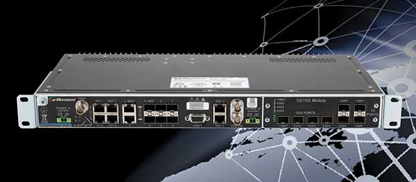
Microchip Technology Inc., via its Microsemi subsidiary, has added the TimeProvider 4100 Release 2.0 to its Precision Time Protocol (PTP) PackeTime portfolio.
TimeProvider keeps services operating through GNSS lapses due to vulnerabilities such as jamming, spoofing or loss of signal. It is also designed to meet one of the biggest 5G network deployment challenges —synchronizing higher volumes of more densely packed base stations.
Microchip is also introducing Release 3.0 to its Integrated GNSS Master (IGM) family.
TimeProvider 4100. Release 2.0 adds 10 Gigabit Ethernet support, a boundary clock operation mode that lowers operational costs, and other enhancements to improve how timing flows are distributed from multiple sources to a network’s base stations and other endpoints.
The 72-channel GNSS receiver coupled with Microsemi’s patented active thermal compensation technology provides excellent accuracy of <10 ns RMS to UTC (USNO). With the time source provided through GNSS satellite input, it is essential to provide flexible support for constellations of choice depending on the region. TimeProvider 4100 supports GPS, GLONASS, BeiDou, Galileo, QZSS, and SBAS in its standard version.
TimeProvider 4100 2.0 with its 10 GE expansion module has been selected by SK Telecom in Korea for its delivery of 5G services in the Seoul metropolitan area and Chungcheong province.
IGM 3.0. For service providers that need to deploy more compact PTP 1588 v2 Grandmasters to fewer base stations closer to the network’s edge, Microchip is also introducing Release 3.0 to its Integrated GNSS Master (IGM) family.
IGM 3.0 combines an IEEE-1588v2 PTP grandmaster with a GNSS receiver and antenna to simplify indoor or outdoor installations. Each of the three IGM 3.0 additions deliver precise time and phase as well as new capabilities enabled by IGM Plus hardware models with enhanced oscillators and GNSS receivers.
The new oscillator options extend time-keeping holdover performance while the enhanced receiver speeds satellite signal acquisition and improves security by accessing more GNSS constellations simultaneously.
The receiver upgrade option supports GPS, Galileo, QZSS and GLONASS, and is Beidou-ready. The IGM 3.0 software includes higher PTP capacity to 60 clients along with IPv6 support for traffic and management flows.
TimeProvider’s Gateway Clock. Extending the TimeProvider 4100’s Gateway Clock operation mode with Microchip’s high-performance boundary clock (HP-BC) operation mode enables it to support the latest high-accuracy ITU-T Class C & D boundary clock standards. These standards dictate extremely accurate time transfer over optical networks so operators can use dense wavelength division multiplexing (DWDM) technology rather than dedicated fiber.
Release 2.0 accommodates escalating bandwidth requirements of next-generation network devices through an optional expansion module that provides 10 GE interfaces. Expanded monitoring functions enable service providers to understand how time and phase performance is affected by network elements, the company added.
PTP client capacity has been increased to 790 to provide the scalability that is critical for deployments in mobile network aggregation layers and new DOCSIS 3.1 Remote-PHY cable architectures.
Both TimeProvider 4100 Release 2.0 and IGM Release 3.0 are managed with TimePictra, the centralized and unified management platform for the company’s family of precise timing systems.
BRING YOUR OWN DEVICE (BYOD) is not just an industry buzzword. It can change the way professional surveyors work every day. The idea of using a smartphone or tablet instead of a dedicated device is appealing. But is it good enough?
Surveyors and mappers are challenged with the arduous task of data collection that meets accuracy and precision standards and provides adequate attribute information for the project. Before the invention of the electronic data collector, handwritten notes in field books were the norm. Every note keeper’s style varied in content, neatness and thoroughness. Calculations for determining survey data values were completed longhand on paper and were very time consuming.
Like its personal computer counterpart, the electronic data collector was introduced in the late 1970s with minimal adoption by the average surveyor because of cost and complexity. Storage methods for the era included magnetic modules and tape; both forms of media were expensive and fragile with little storage for the cost.
Data collection was limited to numeric values only, with horizontal and vertical angles, slope distance, point number and point code being the extent of the information. Couple this process with the limited availability of printers and plotters capable of depicting the data for the surveyor’s use, and one can see why few practitioners invested in these systems.
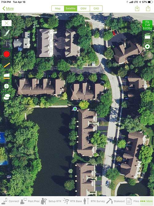
iOS aerial viewer. (Screenshot: Tim Burch)
The 1980s and 1990s brought significant changes to surveying with the advancing technology of electronic computing and measuring. The introduction of robotic total stations, various methods of GNSS, and even leveling took advantage of significant computer power and measuring processes, and the data collector stayed in lockstep with the advancing instrumentation. Almost every equipment manufacturer developed their own proprietary data collector and software system because of the unique design and programming of their systems.
In the 2000s and later, third-party manufacturers began producing data collectors with advanced computing power and the ability to connect to varying brands of equipment. Most of the programming for these collectors are still proprietary in nature to this day.
Also during the 2000s, a new wave in mobile communications was taking place. Cellular phone and data signals were now being used to transmit an abundance of information between users.
The rapid development of handheld communication devices has led to the meteoric rise of two specific mobile operating systems: one by a radical startup that concentrated on dominating the search engine market, and the other by an avant garde computer company looking to expand its unique customer base.
By the end of the decade, the world had been introduced to the Android operating system by Google, and the iOS operating system by Apple. The combined market share for the two operating systems at press time was just under 98 percent of all mobile devices worldwide.
Trending Away from Proprietary Data Collectors
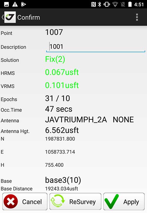
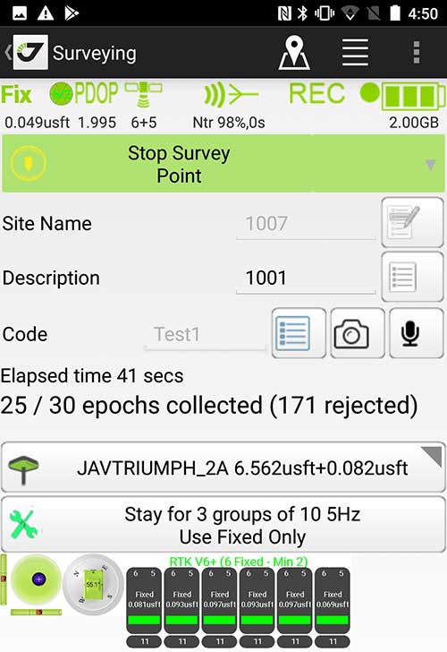
Android Point Info: Confirmation of collected data, including equipment and base station. (Screenshot: Tim Burch)
Because data collection by surveyors and mappers have traditionally been performed on proprietary systems designed and produced by equipment manufacturers for use with only their instruments, these collectors, while very powerful and robust, are costly for the equipment manufacturers to produce because of the limited market of surveyors and mappers.
Many suppliers, before the introduction of the iPhone and Android operating systems, attempted to adapt their data-collection platforms to wider recognized mobile operating systems (for example, Windows CE/Pocket PC/Mobile) on a bevy of mobile devices (HP/iPAQ, Sony Eriksson, HTC) with little success. Various versions of Windows are still being used today by GNSS equipment manufacturers’ proprietary data collectors, including Trimble, Hemisphere GNSS, Topcon and CHC Navigation.
However, the field of operating environments has become more crowded as technology continues to advance. The proliferation of Windows-based data collectors are now on the decline.
Survey Point: Status of survey data collection and GNSS engine signal reception. (Screenshot: Tim Burch)
Enter Android and iOS. Driving the decline of the previously popular Windows mobile platform is the rapid adoption of the iOS and Android operating systems. These two environments have also led to a substantial number of devices and applications for users.
Part of the reason for the speedy acceptance of the devices and operating systems has been the ease of programming. It is estimated that each operating system has more than two million applications in their respective online stores, with more being introduced daily.
Because of the proliferation of smartphones, nearly everyone is familiar with the look, feel and operation of touchscreen devices and their various applications. This familiarity is driving a new trend in data collection: the concept of “bring your own device” (otherwise known in IT security circles as “BYOD”). BYOD is being introduced by several surveying and mapping equipment manufacturers as an alternative to their proprietary data-collection devices.
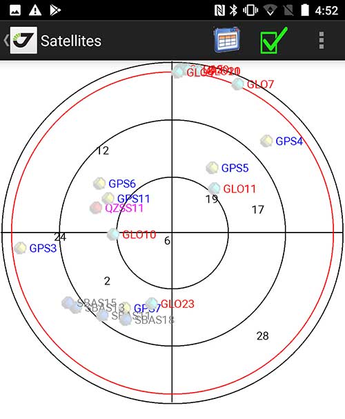
Sky Plot: Where the ‘birds’ are in the sky. (Screenshot: Tim Burch)
These manufacturers are pairing iOS and Android developers with their hardware and firmware specialists to create a user-friendly interface that will function on most of the most popular handheld devices on the market today. From Apple iPhones and iPads to Samsung Galaxy phones and tablets, these applications give the surveyor the best of two worlds — sophisticated data-collection capability on a well-known and reliable mobile operating system platform.
The Android platform is becoming especially popular in the handheld mapping market segment. Current users of this environment include Hemisphere GNSS, CHC Navigation, Tersus GNSS and Trimble.
The iOS applications, while not quite as prevalent as Android, are being embraced by several significant GNSS manufacturers, including JAVAD GNSS and Eos Positioning Systems.
These companies are creating iOS and Android apps that embrace the BYOD market, providing their users with affordability and creating a comfort level simply because of the familiarity of the device and its environment.
How Good Is It?
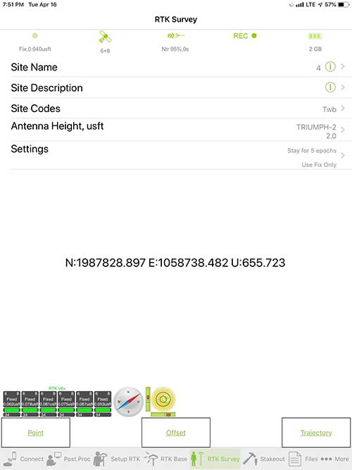
iOS Position. Status of survey data collection and GNSS engine signal reception. (Screenshot: Tim Burch)
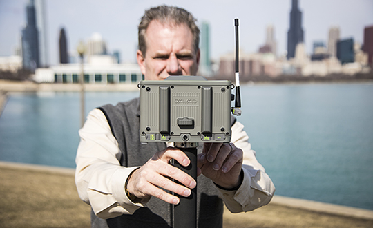
For the surveyor to be satisfied with the operation, the collection process must be efficient, cost-effective and easy to use. For this explanation of key items within a well-rounded data-collection application, we are using the JAVAD Mobile Tools (now J-Mobile) application built specifically for the Android and iOS operating systems.
The Android system (Version 7.0) was installed on a rugged CAT S41 cellphone made Bullitt Group from the United Kingdom, while the iOS app was used on the author’s iPad Air 2 running Version 12.2. Both apps were utilized in conjunction with the JAVAD Triumph-2 GNSS receiver.
After putting both versions through trial testing and checking against values on known monuments, here is the results of our findings:
Receiver Setup. Visual reference for leveling and direction of GNSS receiver. (Screenshot: Tim Burch)
Data Organization. Easy to comprehend and flexible for most naming conventions.
Corrections and Sources. Easily connects to base receiver and radio or available NTRIP correction service for real-time network (RTN) capability.
Sky Plot. Because the Triumph-2 is equipped to receive most of the available satellites in service, the Sky Plot feature is beneficial to the user for assessing potential interference.
File Management, Import and Export. Covers the typical file management and transfer functions used by the surveyor.
RTK Survey Operations. Robust telemetry keeps the users informed of specific satellite data and correction status.
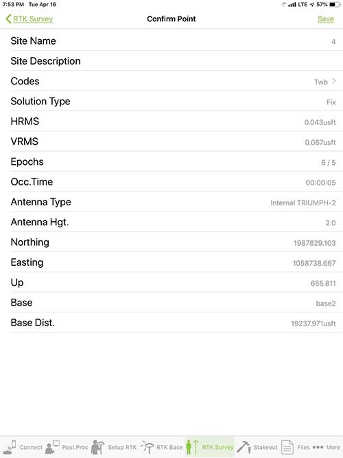
Point Confirmation. Survey point information with metadata and equipment listing. (Screenshot: Tim Burch)
Coordinate Systems. All standard coordinate systems are included with features to allow the user to customize their own systems.
Localization. Creation of a local coordinate system is a simple routine, providing strong quality checks for data integrity.
Lift and Tilt. This feature provides the user with a useful procedure to end data collection without the need to press a button. This feature significantly increases the user’s productivity.
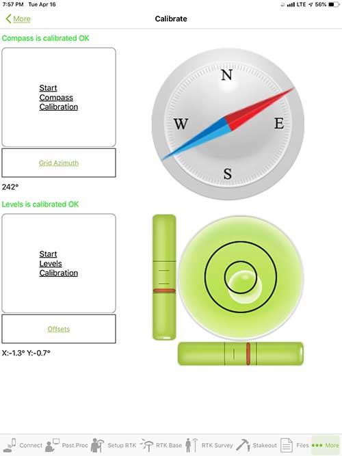
Compass and Level Calibration. With the Triumph-2 having an internal compass and level system, status of the receiver is graphically displayed to help the user keep a close watch on the accuracy of the survey point.
Survey Points and Linework. Most point naming systems and line-coding procedures are easily adapted. Total Station Point Transfer. The creation of control point files for transfer to total stations is simple and easy to use.
Stakeout. Graphical status screens provide the user with simple plotting capability of the desired stakeout point to increase efficiency and accuracy.
These apps are good at providing the surveyor with a solid tool for data collection and staking capability. They are especially good when paired with a real-time kinematic
(RTK) base station or NTRIP correction service.
But what happens when cell service is not readily available, or there are no published monument coordinates to establish site control? These apps have the surveyor covered for that situation as well.
Post-Processing (OPUS and DPOS)
Today’s surveyor works in an environment where geographic-based data is a key component to the services they render to their clients. While most of the world’s developed nations have access to cellular networks in which most GNSS receivers can communicate with an RTN providing corrective solutions, the places where this is not possible relies on other means of data correction.
In the U.S. we rely on OPUS (Online Post-Processing User System) to provide that service. But, as good as it is, it has limitations. Currently, it only utilizes GPS satellite data from the U.S. Department of Defense and is subject to sporadic government shutdowns.
Other services, from both public and private sources, are in place around the world to provide a service similar to OPUS. These include, but are not limited to:
AUSPOS. Geoscience Australia (free)
APPS. Jet Propulsion Laboratory at California Institute of Technology (free)
CSRS-PPP. Natural Resources Canada (free)
GAPS. University of New Brunswick (free)
magicGNSS. GMV (free)
Centerpoint RTX Post Processing. Trimble (free)
JAVAD Data Processing Service (DPOS). JAVAD (free, processes any JAVAD GNSS jps file)
These correction services utilize other satellite constellations (GLONASS, Galileo, BeiDou and QZSS) for their solutions and can provide additional coverage, depending on the location of the user. Because of these services, geographic-based data is at the fingertips of surveyors worldwide.
JAVAD’s DPOS system is has the ability to collect static survey data and send it to the proprietary service for establishing new coordinate values for base-station use. This process is a function of the app and can be completed in a few short steps.
Once the base station values are calculated, the surveyor can make use of this information for establishing a base station for correction broadcasting.
Do You Need a Base Station?
The establishment of RTNs has greatly enhanced surveying capability as cellular service has increased in coverage and speed. However, there are still instances and locales that do not allow for the reliable use of cell signals to provide those corrections accurately.
Various manufacturers’ tests have proven the accuracy of using an RTN subscription versus the traditional GNSS base and rover RTK setup. But cell-signal strength can be an Achilles heel, crippling those who choose not to set up a base station.
The UHF radio, even in its reduced power state from regulatory changes, is still more powerful and reliable than most cell services. 5G technology and coverage is anticipated to revolutionize cellular service, but it has yet to be realized.
Adaptation of the Industry
Other GNSS manufacturers (including NovAtel, Navcom, ComNav, Unicore, Emcore, Suzhou, TeleOrbit and Geneq) are producing receivers that can be adapted to a variety of existing data collectors and connect to iOS/Android mobile devices through various software developers.
The future of communications remains the smartphone or tablet device, with foldable units expected to be the next big thing.
As processors get more powerful, as chip memory becomes more abundant, and as more satellite constellations orbit in our sky, surveyors and their data collectors will continue to evolve. The future remains bright for technology and the surveyor has a front-row seat.
TIM BURCH is GPS World’s contributing editor for Survey. A professional land surveyor with more than 30 years of experience, he is director of surveying at SPACECO Inc. in the Chicago area. For several years he has been secretary and was recently named vice-president of the Board of Directors of the National Society of Professional Surveyors. He writes a bi-monthly column in the Survey Scene e-newsletter. Subscribe free at env-gpsworld-integration.kinsta.cloud/subscribe.
Receiver, Software Ready for Mobile
Photo: ComNav
ComNav receivers offer multiple data-collection device choices via Bluetooth connection, as well as an Android app.
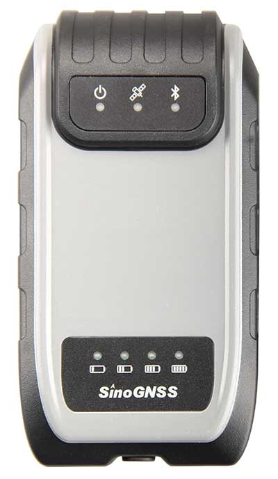
For instance, the G200 provides centimeter-accuracy positioning to any connected mobile devices for RTK field surveying. It is able to delivery robust survey workflows with the SinoGNSS Android-based Survey Master, so that surveyors can collect quality high-accuracy positions no matter what mobile device they are using.
The G200 is a rugged, compact, wearable GNSS receiver. Combined with the high-performance SinoGNSS OEM board tracking GPS L1/L2, BeiDou B1/B2, GLONASS L1/L2, Galileo and QZSS, the G200 enables reliable high-precision GNSS performance for land survey tasks anywhere in the world.
TerraStar Gives Assist to RTK
Photo: Leica Geosystems
NovAtel offers several levels of corrections via its TerraStar service. For surveying applications, the RTK Assist service provides correction data to bridge surveyors through any real-time kinematic (RTK) correction outages. TerraStar services work on NovAtel’s OEM6 and OEM7 receivers..
RTK Assist, available on OEM6/OEM7 receivers, provides 20 minutes of RTK assistance, enabling surveyors to maintain centimeter-level accuracy. A higher service level, RTK Assist Pro, is available on OEM7 receivers. It provides unlimited RTK assistance with stand-alone centimeter-level positioning when RTK is not available.
Trimble Offers Web-Based Post-Processing
Photo: Trimble
Trimble’s CenterPoint RTX Post-Processing Service is a free, web-based solution that provides rigorous processing of GNSS data for users around the globe.
Powered by advanced algorithms for processing static observations, CenterPoint RTX Post-Processing supports data including GPS, GLONASS, Galileo, BeiDou and QZSS. With the service, users can upload GNSS data using Trimble formats or industry-standard RINEX 2 and RINEX 3. The service supports all dual-frequency GNSS receivers and more than 400 different antennas.
The post-processing service computes single-station static observation sessions ranging in length from 10 minutes up to 24 hours, with longer observation sessions recommended to produce the highest accuracy. Using data from the global RTX tracking network, the CenterPoint RTX Post-Processing service computes the position of the observed point with centimeter accuracy.
Results are delivered via email in ITRF coordinates at the current epoch and can be transformed to a fixed epoch by use of a standard tectonic-plate model.
Atlas Corrections Ready for BYOD
The Atlas GNSS global correction service, offered by Hemisphere GNSS, provides correction data for GPS, GLONASS, BeiDou and Galileo constellations. Its global L-band corrections allow for accuracies ranging from sub-meter to sub-decimeter levels. The network has more than 200 reference stations worldwide and covers virtually the entire globe.
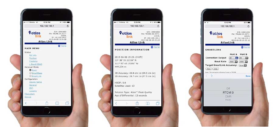
Examples of how the AtlasLink webUI looks on a smartphone. (Image: Hemisphere GNSS)
The Atlas platform was conceived to enable as many people as possible to have access to the correction service technology, either as an end-user or as part of their business. Several features are designed to enable customers who use non-Hemisphere positioning systems to have access to Atlas.
For instance, Hemisphere’s SmartLink technology allows an AtlasLink GNSS smart antenna to be used as an Atlas signal extension for any GNSS system compliant with open communication standards.
Hemisphere’s GNSS smart antennas including AtlasLink, A326, C321+ and S321+ offer a user-friendly web user interface (WebUI) that can be used to configure, monitor and manage the receiver from virtually any modern computing device, including computers, phones and tablets.