Category: Applications

  • Allystar offers dual-antenna GNSS-aided INS platform

    Allystar offers dual-antenna GNSS-aided INS platform

    The Allystar INS Platform — the company’s latest technology — is a dual-antenna, multi-frequency, multi-GNSS inertial navigation system (INS) that delivers accurate and reliable position, velocity and orientation, the company said.

    It is designed for a wide range of autonomous vehicle applications under the most demanding conditions.
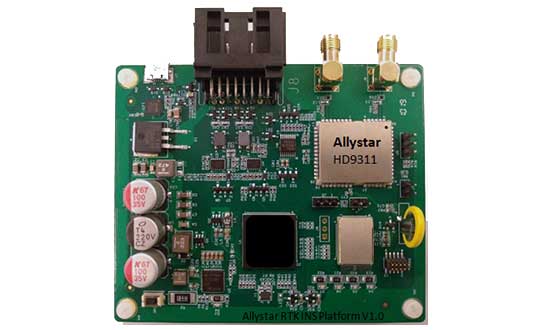
    Allystar RTK/INS Evaluation Board V1.0. (Photo: Allystar)
    Allystar RTK/INS Evaluation Board V1.0. (Photo: Allystar)

    The Allystar INS Platform combines high-grade, six-axis, temperature-calibrated accelerometers and gyroscopes with a multi-frequency, multi-GNSS engine, the HD9300 series. HD9300 is a dual-antenna chip-grade real-time kinematic (RTK) GNSS receiver for accurate positioning and heading.

    GNSS-aided inertial navigation systems are widely used in autonomous vehicles. However, high-accuracy multi-frequency multi-GNSS receivers are usually too expensive for mass-market applications. The Allystar HD9300 series is a mass-market multi-band chip-grade receiver that concurrently support all civil bands in all GNSS constellations (GPS/QZS L1&L2&L5&L6, BDS B1&B2&B3, GAL E1&E5, GLO L1OF/L2OF) with an integrated RTK engine to achieve centimeter-level accuracy.

    The Allystar INS platform contains an on-board sensor-fusion filter, navigation and calibration algorithms for different dynamic motions of land vehicles. Key features include:

    • multi-band multi-GNSS chip-grade receiver
    • dual antennas
    • integrated RTK engine (up to 2 centimeters)
    • 100-hz update rate
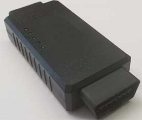
    • OBD data adapter.
    Allystar OBD Data Adaptor V1.(Photo: Allystar)
    Allystar OBD Data Adaptor V1. (Photo: Allystar)

    The Allystar OBD Data Adapter (v1.0) enables users to read and monitor various sensors built into cars, obtaining the real-time vehicle speed and gear signals from the OBD interface, and then output AT commands by serial port or SPI. When connected to the Allystar RTK INS platform, the adapter allows for outstanding navigation accuracy, especially in urban areas, helping to increase accuracy and reduce position drift.

    An evaluation kit — including platform board, antenna and OBD adaptor — will be available in August.

  • STMicroelectronics GNSS module targets mass-market navigation

    STMicroelectronics GNSS module targets mass-market navigation

    Image: STMicroelectronics
    Image: STMicroelectronics

    STMicroelectronics has grown its GNSS product offering with the Teseo-LIV3R ROM-based module. The module provides ST’s full GNSS algorithm capability for cost-conscious tracking and navigation devices.

    ST’s new GNSS module provides odometer functionality with three trip counters and reached-distance alert, along with geofencing capabilities with up to eight configurable circles and crossing-circles alarm. Support for real-time assisted GNSS with free server access ensures uninterrupted positioning data for dependable navigation.

    Simultaneous tracking of GPS, GLONASS, BeiDou and QZSS constellations, with satellite-based augmentation system (S-BAS) and Radio Technical Commission for Maritime Services (RTCM) V3.1 differential positioning ensures excellent accuracy to within 1.5 meters (50% circular error probability, CEP).

    Tracking sensitivity of -163 dBm and time-to-first-fix faster than one second ensure high performance for demanding applications. The module is easy to use and responds to proprietary National Marine Electronics Association (NMEA) commands.

    With scalable power consumption according to accuracy, average current, and frequency of fixes, a sub-15µA standby mode with RTC backup, and support for multiple low-power modes, Teseo-LIV3R is an ideal choice for battery-sensitive applications. The low-power modes include continuous-fix with adaptive and power-saving cycled modes, periodic-fix with GPS only, and fix-on-demand with the device in permanent standby.

    To simplify and accelerate new-product development, the module is FCC certified and is supported by the STM32 Open Development Environment. STM32 applications for advanced geolocation, smart tracking, and server-assisted GNSS are available, while the EVB-LIV3x evaluation board and X-NUCLEO-GNSS1A1 expansion board provide a head-start with hardware. The Teseo Suite PC tool helps easily configure settings and fine-tune performance. Developers can also join the ST GNSS community to share information and increase their understanding of the field.

    The Teseo-LIV3R is in volume production. The 9.7mm x 10.1mm LCC18 module is priced from $7.3 for orders of 1,000 pieces.

  • Hexagon products expand reality capture options

    Hexagon products expand reality capture options

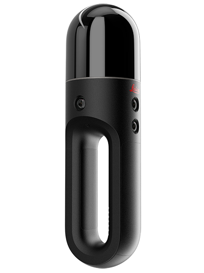
    The Leica BLK2GO. (Photo: Hexagon)
    The Leica BLK2GO. (Photo: Hexagon)

    Hexagon AB has introduced two new additions to its Leica BLK series. The Leica BLK2GO is a small, portable, integrated handheld-imaging scanner, and the Leica BLK247 is a 3D laser-scanning sensor for security surveillance providing continuous, 24/7 situational awareness.

    “Extending the BLK series continues Hexagon’s 20-year focus on revolutionising reality capture,” said Ola Rollén, Hexagon president and CEO. “These sensors are not only ground-breaking for their technical capabilities, but also for their practicality. The Leica BLK2GO can be taken anywhere, and the Leica BLK247 never sleeps.”

    Leica BLK2GO. The Leica BLK2GO introduces mobility for scanning complex indoor environments. The handheld-imaging laser scanner combines visualisation, lidar, and edge-computing technologies to scan in 3D while in motion, allowing users to be more agile and efficient in capturing objects and spaces.

    The BLK2GO has a wide range of applications from adaptive reuse projects in the architecture and design industries to location scouting, pre-visualisation, and VFX workflows for media and entertainment.

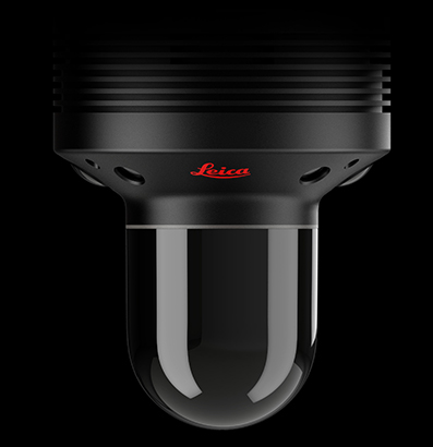
    The Leica BLK247. (Photo: Hexagon)
    The Leica BLK247. (Photo: Hexagon)

    Leica BLK247. The Leica BLK247 is designed for continuous 3D reality capture, extending capabilities for safety and security applications. The sensor provides real-time situational awareness through edge computing and LiDAR-enabled change-detection technology.

    Using artificial intelligence, the BLK247 can tell the difference between still and moving objects — such as a person walking who leaves a suitcase behind — and identify security threats to provide real-time alerts for both expected and unexpected changes.

    The BLK247 greatly enhances situational awareness within restricted or high-security spaces, as it eliminates the need for people to constantly monitor walls of security screens or smart building dashboards.

    The Leica BLK2GO and Leica BLK247 are among the many innovative solutions showcased this week at HxGN LIVE 2019, Hexagon’s annual digital technology conference.

  • CHC Navigation offers 8-inch professional tablet

    CHC Navigation offers 8-inch professional tablet

    Photo: CHC Navigation
    Photo: CHC Navigation

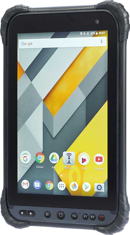
    CHC Navigation has launched its LT700 rugged Android tablet. The LT700 is designed to increase the efficiency and productivity of the mobile workforce in different industries and applications.

    An integrated GNSS module (GPS/GLONASS/BDS/SBAS) provides robust positioning performance. The LT700 dual-SIM 4G modem ensures fast and reliable connection with mobile teams.

    The LT700 tablet features an 8-inch sunlight-viewable touchscreen. It displays geospatial information system (GIS) data tables, complex vector and raster maps, or high-resolution pictures in direct sunshine and high-bright areas, CHC Navigation said.

    Unlike consumer-grade tablets, the L700 is intended for mobile field workers. Its industrial IP67 design withstands all-day use in harsh environments and conditions, and is protected from dust, rain, extreme temperatures and accidental drops from 1.2 meters. Rugged design, soft corner bumpers and long battery life provide the LT700 with the capability to perform uninterrupted for a complete working day.

    The LT700’s octa-core 2.2-GHz CPU supports running large maps and datasets without any lag or slowdown. Driven by Android 8.1 and bearing the GMS (Google Mobile Service) certification, the LT700 runs seamlessly the most common professional data collection applications available from the Google Play store.


  • Polaris joins Mark43 on location-enabled dispatch for emergency departments

    Polaris joins Mark43 on location-enabled dispatch for emergency departments

    Polaris Wireless is partnering with Mark43 to integrate 3D location technology into computer-aided dispatch systems for public safety organizations. Polaris Wireless is a provider of software-based wireless location solution.

    The joint solution will enable police and fire departments to track personnel and assets with pinpoint location, including indoors and in high-rise buildings, with floor-level accuracy. It delivers enhanced situational awareness and improved operational efficiency, which helps save lives and additional costs.

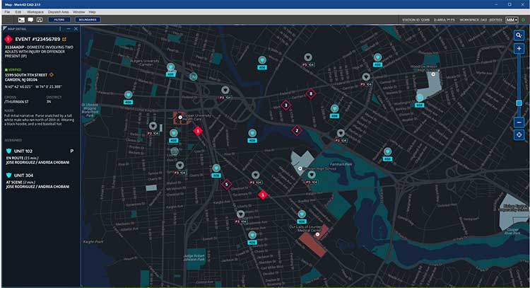
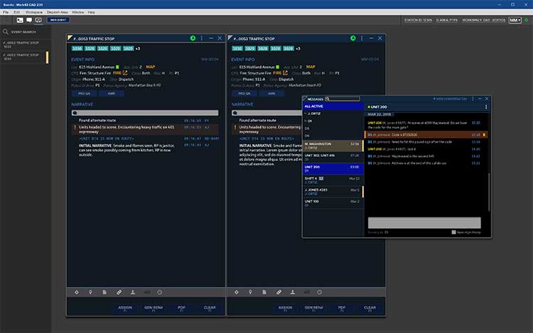
    Mark43 Computer Aided Dispatch and Automatic Vehicle Location. (Screenshot: Mark43)
    Mark43 Computer Aided Dispatch and Automatic Vehicle Location. (Screenshot: Mark43)

    Mark43 is a cloud-based public safety software provider. Its Mark43 CAD software provides mobile field units with precise information on laptops or tablets inside a vehicle. Built on AWS GovCloud, Mark43 works with police and fire departments to make sure web-connected units stay mobile in the cloud.

    With the addition of 3D location, command and control centers can direct firefighters to the correct floor in a structural fire or ensure SWAT teams enter at the correct floor of a high-rise building. In more routine situations, such as tracking officers or equipment in a large municipal headquarters, 3D location helps increase efficiency and allocate resources more wisely.

    Mark43 is purpose-built in the cloud to support interoperability with third-party systems and devices. This enables the Mark43 CAD to seamlessly integrate with the Polaris Wireless 3D Location Platform, which is cloud-based and available to application developers via a standard Android and iOS Software Development Kit (SDK).

    The platform relies on Polaris Wireless’ 3D location technology, which is able to locate devices on the vertical axis within 3 meters, floor level, utilizing all available signals and sensor measurements combined with the company’s patented algorithms.

    Screenshot: Mark43
    Screenshot: Mark43

    By operating independently, or “over the top,” of wireless carrier networks, the platform is universal, enabling applications to locate any device on any network — an important consideration when police and fire departments operate devices across several networks.

    “Giving command and control centers full visibility into first responders’ locations is crucial when it comes to emergency dispatch, where every second counts,” said Scott Crouch, Mark43 co-founder and CEO. “We are always aiming to integrate the best possible capabilities into our suite of offerings, and we look forward to working with Polaris Wireless to increase safety and efficiency for our first responders.”

    “Our 3D location is enabling new use cases in public safety applications with our partnership and integration into Mark43 CAD systems,” said Amir Sattar, senior vice president of operations for Polaris Wireless. “Dispatching police and firefighters to the precise location, including the correct floor number, represents a major advancement for public safety and a significant benefit for the communities they serve.”

    Polaris Wireless and Mark43 are exploring opportunities to trial the application with public safety organizations.

    Attendees at the NENA 2019 Event (June 14-19) in Orlando, Florida, can visit Mark43’s booth #321 to learn more.

  • Hexagon’s M.App Enterprise 2019 features 3D, machine learning

    Hexagon’s M.App Enterprise 2019 features 3D, machine learning

    LogoHexagon’s Geospatial Division launched M.App Enterprise 2019 at its user conference, HxGN LIVE 2019. The latest version of M.App Enterprise integrates capabilities from Hexagon’s Luciad Portfolio to enhance data visualizations, analytics and management.

    Designed to monitor assets, evaluate changes, and take action, M.App Enterprise is a privately-hosted platform that allows organizations to deploy Hexagon Smart M.Apps that dynamically address their location-based business problems.

    The new features in M.App Enterprise 2019 lay the foundation for users to experience a 5D smart digital reality, where data is connected seamlessly through the convergence of the physical world with the digital and intelligence is built into all processes.

    Screenshot: Hexagon Geospatial
    Screenshot: Hexagon Geospatial

    “The enhanced M.App Enterprise is now powered by our Luciad technology, which allows users to have the best of both worlds when it comes to data visualization and advanced analytics to communicate information effortlessly, and in real-time,” said Georg Hammerer, chief technology officer – applications for Hexagon’s Geospatial Division. “This unified geospatial enterprise platform can now further enable users and partners to create vertical solutions for their markets and industry segments.”

    The Luciad Portfolio integration will allow users to connect to, visualize and examine file-based vector and raster data from their Smart M.Apps in 3D. It also now renders terrain features realistically based on elevation data of the area.

    For covering large geographical areas with a higher resolution, M.App Enterprise 2019 allows users to connect to tiled elevation coverages offered by LuciadFusion.

    Furthermore, the addition of classification algorithms to the Spatial Workshop user interface enables M.App Enterprise to perform advanced remote sensing with machine learning.

  • NovAtel defense manager joins anti-jam webinar panel

    NovAtel defense manager joins anti-jam webinar panel

    Headshot: Dean Kemp
    Dean Kemp

    Dean Kemp, defense segment manager for NovAtel, has joined the speakers’ panel for the June 27 complimentary webinar, Advanced Simulation Test Systems for Controlled Reception Pattern Antennas. He will present unique content alongside Lisa Perdue, simulation product manager for Orolia, and Stéphane Hamel, director of testing at Orolia.

    Kemp has over 20 years of academic, industrial and business experience in engineering products and services. He spent a significant part of his career involved in antenna design and development, including controlled reception pattern antennas (CRPAs) for GPS anti-jam systems. As Defense Segment Manager, he is committed to precise, assured positioning and timing to address the needs of Navigation Warfare (NAVWAR) professionals and is dedicated to delivering high-quality products into the defense markets.

    He holds a Ph.D. in antennas, radiowave propagation and computational electromagnetics from the University of Liverpool and an MBA from the University of Warwick. Prior to joining NovAtel, he worked at API Technologies, Cobham and Cobham Technical Services. His key technical skills include antenna/RF/microwave engineering, software development (Matlab, Fortran, VBA, Python), data analysis and processing, and test and measurement.

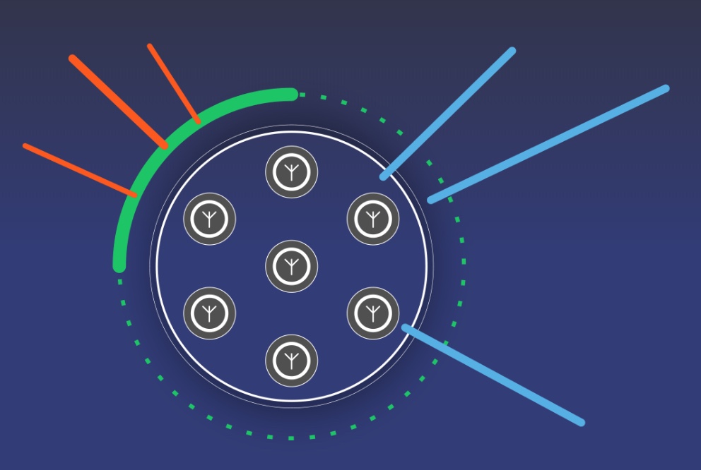
    CRPAs are advanced, multi-element antenna solutions designed to protect a GNSS/GPS receiver from jamming sources. When combined with antenna electronics, they form an anti-jam antenna system (AJAS). These systems utilize several available technologies and vary in the number of elements.

    This webinar will cover the basics of AJAS and CRPA, and the methods used to test them. Details on simulation system configurations, calibration techniques, and use case examples will also be presented. The webinar is sponsored by Orolia, a global provider of GPS/GNSS and resilient PNT solutions to support military and commercial applications.

  • Orolia’s new aircraft emergency beacon uses Galileo service

    Orolia’s new aircraft emergency beacon uses Galileo service

    Orolia’s Kannad Ultima-S emergency locator uses the Galileo Return Link Service. (Photo: Orolia)
    Orolia’s Kannad Ultima-S emergency locator uses the Galileo Return Link Service. (Photo: Orolia)

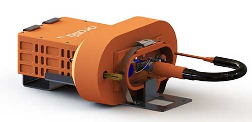
    Orolia is introducing a new product for commercial aircraft safety, the Kannad Ultima-S emergency locator transmitter (ELT).

    The Kannad Ultima-S is designed to be installed in the cabin of commercial aircraft or in its life raft. It is capable of notifying the crew about the launch of a search-and-rescue operation via Galileo Return Link Service (RLS).

    For passengers, installation of the Kannad Ultima-S means their flight can located accurately, with rescue following if an aircraft evacuation is needed.

    Orolia’s Kannad Ultima-S ELT was developed under a two-year contract through the European GNSS Agency’s Tauceti Project. Orolia says this is the first beacon to use the Galileo RLS.

    Other key features include:

    • Certified to the new lithium battery regulations to avoid the risk of battery fires.
    • A multi-GNSS receiver to accept multiple signals such as GPS and Galileo to detect the aircraft’s
      location faster and deploy rescue teams sooner than before.
    • Dual activation modes: manually or automatically upon contact with water.
    • An RLS option to notify the crew that the distress signal has been received and help is on the way (available on Galileo).
    • Multiple configurations available to install in aircraft cabins and life rafts. With a rugged, compact, and easy-to-install form factor, both versions can be installed through a carry-off bag or a mounting bracket and require little storage room.

    Orolia’s Kannad Ultima-S meets new and evolving EASA/FAA requirements related to ELTs and non-rechargeable lithium batteries documented under the RTCA DO-227A standard.

    “Orolia is dedicated to making air travel even safer than it is today with resilient positioning and aircraft location technology, featuring automatic, manual and remote activation modes to provide a complete ELT portfolio,” said Christian Belleux, Aviation Product Line director at Orolia. “We are excited to present aircraft operators with an affordable, reliable and state-of-the-art ELT solution for cabin modifications or linefit installations.”

    The new ELT benefits from the proven Cospas Sarsat infrastructure, which is being upgraded to provide highly accurate location data and nearly real-time reporting to search-and-rescue operators through global coverage.

    Kannad Ultima-S survival distress beacons complement Orolia’s Ultima family of next-generation ELTs, following the company announcement of the Global Aeronautical Distress and Safety System (GADSS)-compliant fixed Ultima-DT. Orolia provides aircraft manufacturers and operators with a complete solution for every ELT application.

    Orolia will exhibit at the Paris Air Show June 17-20, Hall 2B booth E32, where both new ELTs will be displayed for the first time.

  • ADS-B problem with GPS stems from faulty receiver

    ADS-B problem with GPS stems from faulty receiver

    Image: FAA
    Image: FAA

    ADS-B transponder problems on some aircraft stem from a bad update to a large class of aviation receivers, according to a blog on the Resilient Navigation and Timing Foundation website. The Air Traffic Control System Command Center issued a blanket waiver on June 9 for all flights having GPS/ADS-B issues with their transponders.

    According to various sources, the disruption briefly grounded entire fleets of regional jets. The resulting delays and cancellations rippled through the system.

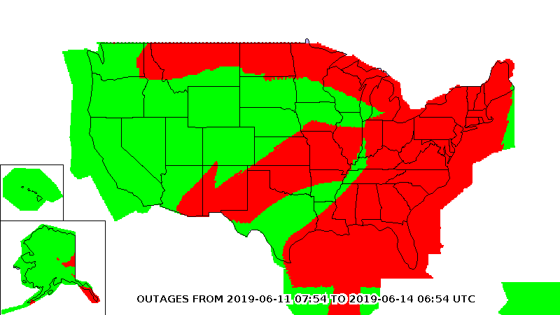
    On June 9, the FAA published a map purporting to show an area of GPS signal degradation in the United States. However,  the disruption appears to affect only certain Collins Aerospace (formerly Rockwell Collins) GPS receivers, according to AIN Online.

    Collins Aerospace confirmed to AIN, “We identified a technical issue with our recently released GPS product(s) impacting availability, and have since determined the root cause and the resolution. We are engaging with our customers to ensure continued safe operational capability.”

    The affected GPS receivers are GPS-4000S part number 822-2189-100 and GLU-2100 part number 822-2532-100.  It appears that all aircraft worldwide these receives are not able to locate satellite position signals.

    “The absence of reports of problems from other modes of transportation and other industries certainly seems to justify refocusing from GPS signals to receivers as the root cause….” said the RNTF blog. “This is a good reminder for all that great signals in space are just one part of a ‘gold standard’ system. We also need unobstructed spectrum, great receiving equipment, and more than one source of great signals.”

  • 3D location platforms aids hotels, public safety indoors

    3D location platforms aids hotels, public safety indoors

    Orion Labs has released Advanced Location Services, a high-accuracy, carrier-independent 3D location platform delivered via Polaris Wireless.

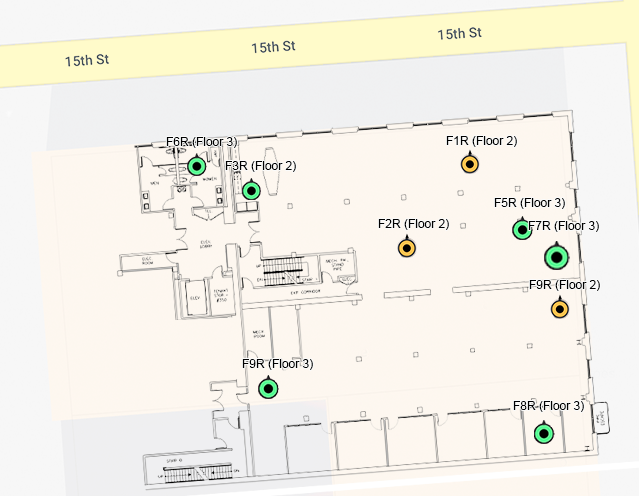
    The service provides enterprises and public safety agencies with pinpoint location, indoors and in high-rise buildings, with floor-level and room-level accuracy, a difficult challenge in such GPS-denied environments.

    Orion indoor location example (Screengrab: Orion)
    Orion indoor location example (Screenshot: Orion Labs)

    The system enables customers to locate team members on the vertical axis accurate to three meters’ distance, to keep teams better-informed and better-connected, enhance team performance and improve worker safety. It works via Orion Sync, a standalone smart walkie-talkie, or as device as a service, in a smartphone form factor.

    “For our hospitality and retail customers, this offers the opportunity to greatly improve guest services and the experience they deliver. For public safety and healthcare customers, the integration has the potential to save lives,” said Jesse Robbins, founder and CEO.

    According to co-founder and CTO Greg Albrecht, “With 3D location tracking, hospitality teams can easily pinpoint where their guest service workers are located and identify the right team member for faster guest response for tasks like bringing up clean towels to a guest, fixing a TV or lightbulb in a guestroom, or clearing trays and carts,” he said.

    The system also protects lone workers. “When lone workers call for help, security teams can rapidly dispatch assistance without the lone worker needing to explain their location,” Albrecht said. “This is the same kind of technology that first responders are now adopting to accurately and rapidly locate 911 callers facing life-threatening situations.”

    Hotel workers suffer work-related incidents at a nearly 50% higher rate than other industries. (Photo: Dean Drobot/Shutterstock.com)
    Hotel workers suffer work-related incidents at a nearly 50% higher rate than other industries. (Photo: Dean Drobot/Shutterstock.com)

    Hotel workers suffer work-related incidents, encompassing physical injuries, medical emergencies, theft and sexual harassment, nearly 50 percent more than is the average across all other industries. Large metropolitan hotels can approximate small cities, with as many as 5,000 rooms, 12,000 guests, and 8,000 employees. Even a moderate-sized hotel can have hundreds of employees scattered across many floors, some remote from central operations. Locating employees quickly is key to preventing or minimizing incidents.

    Need maps. A fundamental challenge in developing 3D location awareness indoors is the need for accurate, detailed 3D renderings of the physical buildings themselves.

    “For most buildings, this has never been done before and is often an arduous task to accomplish,” Albrecht added. “However, there is a mapping process to allow for precise data points to be leveraged within the Orion platform. It’s a very simple task that can be completed even by the hotel staff at the time of setup. After that, it’s extremely simple to set up teams within the Orion System with a 3D view of their property that they can use.”

    The latest integration is undergoing tests at locations in Las Vegas and San Francisco, with more than 50 locations actively using the set-up.

    In March, Polaris Wireless, a provider of software-based 3D location solutions to wireless operators, law enforcement and government agencies, and location-based application companies, announced the commercial availability of its high-accuracy carrier-independent 3D location platform for application developers.

    In early 2018, Polaris Wireless participated in the CTIA’s Test Bed LLC Stage Z independent vertical location testing in San Francisco, Atlanta and Chicago, achieving floor-level accuracy.

  • U.S. Army to equip light armored vehicles with new GPS anti-jam units

    U.S. Army to equip light armored vehicles with new GPS anti-jam units

    The U.S. Army will send prototype anti-jamming systems to its 2nd Cavalry Regiment, stationed in Europe, in September to aid forces under GPS jamming or spoofing conditions. The first generation of Mounted Assured PNT Systems (MAPS) and anti-jam antennas are nearly ready for integration aboard armored Stryker vehicles, and the Army is already evaluating proposals for an upgraded version incorporating an inertial navigation system (INS) for further resilience.

    The shipment comes in response to widespread Russian jamming of GPS signals from the sub-Arctic to the Middle East, and in tacit, likely tardy acknowledgment of Russian superiority in electronic warfare.

    An Interim Armored Vehicle "Stryker" and AH-64 Apache helicopters with Battle Group Poland move to secure an area during a lethality demonstration as part of Saber Strike 18 in June 2018. (Photo: U.S. Army/Spc. Hubert D. Delany III, 22nd Mobile Public Affairs Detachment)
    An Interim Armored Vehicle “Stryker” and AH-64 Apache helicopters with Battle Group Poland move to secure an area during a lethality demonstration as part of Saber Strike 18 in June 2018. (Photo: U.S. Army/Spc. Hubert D. Delany III, 22nd Mobile Public Affairs Detachment)

    Col. Nickolas Kioutas, Army project manager for positioning, navigation and timing (PNT), announced the move at the annual C4ISRnet conference in Arlington, Virginia. C4ISR stands for Command, Control, Communications, Computer, Intelligence, Surveillance, and Reconnaissance, or more broadly, electronic and other systems, procedures and techniques used to collect and disseminate information.

    Three vendors are providing prototypes for the IMU-equipped second-generation MAPS, or MAPS-2, with testing to begin in September. A MAPS-3 capability, drawing on lessons learned in 1 and 2, may get underway soon. GPS Source, now a subsidiary of General Dynamics Mission Systems, made MAPS-1 and is now competing for MAPS-2.

    The initiative reflects a new approach by the Army of “doing much smaller, iterative programs,” according to Col Kioutas. Traditionally, U.S. armed forces have taken years (and sometimes more years) to develop large, complex weaponry and supporting systems, and then even longer to deploy them. By the time they arrive in the operational theater, they are obsolete.

    Rapid deployment of smaller, quickly designed and manufactured batches creates the opportunity for rapid feedback on what works and what doesn’t, with equally rapid return to the design board and re-manufacture. In other words, “shoot, aim, ready.”

    Kioutas and crew are also flouting another U.S. military tenet, that in which previously “[we] asked for exactly what we wanted and industry built exactly to that. We don’t know exactly what we want. Tell us how we should do this the best, and then we’ll test that.” The PNT program has left requirements broad and open to change, knowing how quickly technology develops — and is shown to be vulnerable.

    The Stryker is an eight-wheeled armored fighting vehicle, basically a lightly armored tank or heavily-armored troop carrier that is more road-friendly, that is, faster, than a tank.  It has several variants of armament, armor and troop-carrying capacity. It saw extensive use in the Iraq counter-insurgency campaign.

  • Two little eyes that can see and navigate

    Two little eyes that can see and navigate

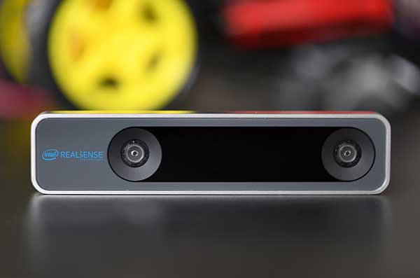
    The RealSense camera uses two fisheye lenses and an IMU to construct location awareness. (Photo: Intel)
    The RealSense camera uses two fisheye lenses and an IMU to construct location awareness. (Photo: Intel)

    The Intel RealSense Tracking Camera T265, designed for positioning and maneuvering mobile robots and other portable systems, includes an inertial measurement unit (IMU) that enables developers to create solutions with advanced depth-sensing and tracking capabilities. Intel introduced the camera in Q1 of 2019. An earlier model, the D435i, also includes an IMU but is a depth camera, not a tracking camera.

    As robots, drones and other autonomous mobile devices must — eventually — interact independently and intelligently with their environments, they must track their locations as they move, navigating unfamiliar spaces while discovering, monitoring and avoiding still and moving obstacles in real time.

    Block diagram of camera components. (Image: Intel)
    Block diagram of camera components. (Image: Intel)

    Moving toward that goal, the T265 includes two fisheye lens sensors, an IMU and an Intel Movidius Myriad 2 video processing unit (VPU), a system-on-chip component for image processing and computer vision at very high performance per watt.

    Vision-based simultaneous localization and mapping (V‑SLAM) algorithms run directly on the VPU with very low latency. The T265 has demonstrated less than 1% closed-loop drift under intended use conditions. It also offers sub 6 ms latency between movement and reflection of movement in the pose.

    The RealSense device measures 1 x 0.5 x 4 inches (108 mm x 24.5 mm x 12.5 mm), weighs around two ounces (55 g), and draws 1.5 watts to operate the entire system, including the cameras, IMU and VPU. Its spatial sensing and tracking capabilities are based on technology developed by RealityCap, acquired by Intel in 2015.

    The camera performs inside-out tracking: it does not depend on external sensors to understand its environment. Tracking is based on information gathered from the two fisheye cameras, each with a 163-degree range of view (±5 degrees) and capturing images at 30 frames per second. The wide field of view from each sensor keeps points of reference visible to the system for a relatively long time, even if moving quickly.

    Visual-Inertial Odometry. A key strength of visual-inertial odometry is that the sensors complement each other. The images from the camera are supplemented by data from the onboard IMU, which includes a gyroscope and accelerometer. The aggregated data from these sensors is fed into the SLAM algorithms.

    The algorithm identifies sets of salient features in the environment, such as a corner of a room or object that can be recognized over time to infer the device’s changing position relative to those points.

    The visual information prevents long-term drift from the inertial that degrades position accuracy. The IMU operates at a higher frequency than the cameras, allowing for quicker response and recognition by the algorithm to changes in the device’s position. A map of visual features and their positions is built up over time. In re-localization, the camera uses the features it has seen before to recognize when it has returned to a familiar place. The camera can locate its point of origin with an error margin of less than one percent.

    Drone testing demonstrated that, in both cases, the tracking and position data generated by the peripheral was closely correlated with what was provided by GPS. This supports the viability of using it for navigation in areas where GPS is not available, such as under a bridge or inside an industrial structure.