Category: Applications

  • NovAtel’s GPS anti-jam technology chosen for UK’s Type 26 frigate

    NovAtel’s GPS anti-jam technology chosen for UK’s Type 26 frigate

    NovAtel’s GPS Anti-Jam Technology (GAJT) has been selected for the United Kingdom’s Type 26 frigates to meet a requirement as part of a protected navigation system.

    The frigates are 21st-century warships that will replace the Type 23 frigate as the workhorse of the British Fleet, undertaking the Royal Navy’s three core roles — warfighting, maritime security and international engagement — on the world stage.
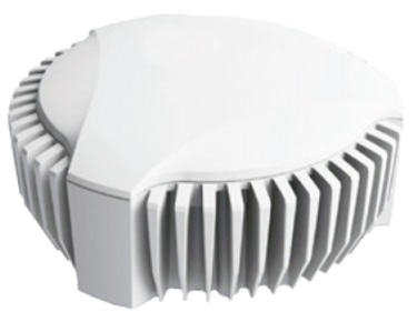
    GAJT-710MS

    GAJT protects GPS-based navigation and precise timing receivers from intentional jamming and accidental interference, ensuring that the satellite signals necessary to compute position and time are always available. It is a commercial off-the-shelf (COTS) product, and comes in versions suitable for land, sea, fixed installations and smaller platforms such as unmanned aerial vehicles (UAVs).

    Warships, military vehicles and platforms, networks and timing infrastructure can all benefit from the protection that GAJT provides. There is no need to replace GPS receivers already installed, because GAJT works with civil and military receivers including SAASM and M-code.

    The Type 26 frigates of the British Fleet will use NovAtel anti-jam technology. (Photo: BAE Systems)

    “The selection of GAJT for the Type 26 frigates is the result of cooperation between Drumgrange, with its proven track record for rapid realisation of demanding defence design tasks, and Forsberg Services, an established navigation systems company and NovAtel dealer whose high quality manufacturing was instrumental to the project,” said Peter Soar, business development manager for military and defence at NovAtel. “GAJT is in use operationally and has been shipped to 16 allied nations around the globe. We are grateful for the rigorous technology selection process conducted which led to this choice.”

    NovAtel’s commitment to precise, assured positioning and timing is central to the design of the GAJT antenna. The company’s lean manufacturing techniques and quality processes mean that it can ramp up quickly to meet volume requirements. Reliability is assured by NovAtel’s industry-best low return rate.


  • Fast forward: Developing future autonomous driving now

    Fast forward: Developing future autonomous driving now

    Enabling the future of autonomous transportation by significantly reducing product development time is the shared goal of three presentations to be made on Thursday, Nov. 30 in a free webinar, “High Accuracy for Autonomous Driving.”

    The speakers will show how they employ post-processing software to generate accurate and reliable ground reference solutions in vehicle testing. The software enables evaluating potential sensor suites, benchmarking solutions, and generating high-definition maps.

    Post-processing the data from autonomous vehicle tests under varying environmental conditions that mirror real-world situations can mitigate GNSS error sources (satellite clock & orbital error, and ionospheric & tropospheric delay); establish an ultra-precise ground truth reference for testing; compare and contrast different sensor packages tested onboard the vehicle; produce customized data formats for exporting information; compare real-time and post-processed quality; transform and translate data between different locations and reference frames; and revisit tests through export to Google Earth. The speakers will show how post-processing forward and back can lead to as much as 40 percent data accuracy improvement.

    The software package, Inertial Explorer, offers this capability, whether lower-grade or high-end inertial sensors are employed.

    Speakers in the free webinar are:

    Steven Waslander, associate professor at the University of Waterloo, heads a project collecting 1,000 km of data in all-weather conditions for a new public road driving dataset focused on autonomous driving challenges. He directs the Waterloo Autonomous Vehicle Laboratory (WAVELab), extending the state of the art in autonomous drones and autonomous driving through advances in localization and mapping, object detection and tracking, integrated planning and control methods and multi-robot coordination.

    Terry Lamprecht, director of products at AutonomouStuff, a supplier of components, services and software that enable autonomy, will discuss verifying proper installation, and creating a baseline data set to benchmark against data collected on autonomous vehicles in real-time.

    Natasha Wong Ken, product manager at Waypoint, will give a high-level technical overview of post-processing techniques and settings, including forward and reverse processing, tightly vs. loosely coupled, PPP vs. differential, and more.

    Registration for the November 30 webinar is free. For those not able to attend the live broadcast, all audio and presentation slide components can be downloaded after air date for viewing at convenience.

  • Remote Geosystems geoDVR deployed for search and rescue

    Remote GeoSystemNorth Shore Rescue and Talon Helicopters have successfully deployed a geoDVR Gen2 with a FLIR daylight EO/IR gyro-stabilized video camera on an Airbus TwinStar (AS355) for search-and-rescue (SAR) missions.

    NSR and Talon team operate the geoDVR and FLIR during ground training in October 2017.
    NSR and Talon team operate the geoDVR and FLIR during ground training in October 2017.

    The geoDVR Gen2 is an advanced mil-spec DVR for recording multiple channels of HD & Standard-Definition geospatial full motion video in airborne and rugged vehicle environments.

    The geoDVR’s ability to reliably record HD color and infrared, along with continuous GPS data and Live Moving Maps, make it suited for professional airborne search and rescue, law enforcement and infrastructure inspection applications that utilize multi-sensor gimbal video cameras.

    “Remote Geo has a reputation for building one of the industry’s most dependable and user-friendly airborne geospatial video recorders, complete with flexible post-flight mapping tools. So the geoDVR Gen2 was an obvious choice when we were asked to fly the FLIR on the TwinStar for mountain search and rescue,” says Peter Murray, Founder/Operations Manager at Talon Helicopters.

    “Adding the FLIR camera to North Shore Rescue’s toolbox has been a great enhancement to NSR’s capabilities,” said Jim Loree, North Shore Rescue SAR manager and air operations coordinator. “Having the ability to record and geo-track the location of the video seemed essential to maximizing the full potential of the FLIR camera. The geoDVR allows searchers to review recorded video for clues that may or may not have been observed during the flight.”

    “This feature could also be highly valuable in a large-scale disaster such as an earthquake where widespread areas are surveyed for damage,” Loree said. “Emergency Operation Centers would be able to use the data to help them make decisions on where and how to deploy resources based on the exact location and extent of damages provided by the video recording.”

    North Shore Rescue and Talon Helicopters will use the geoDVR with a FLIR generously donated by Port of Vancouver to perform helicopter-based SAR operations with color and infrared. Then, using LineVision™ software post-flight, North Shore Rescue will review the geoDVR videos and flight tracks overlaid on Google Earth and Esri maps for training mission planning and recovery operations.

    Because North Shore Rescue is an all volunteer organization, Remote GeoSystems donated 18 LineVision Esri Maps and LineVision Google Earth licenses as part of the implementation.

  • Active digital map for French armed forces will provide decisive mission advantage

    La Direction générale de l’armement (DGA), the French Defence Procurement Agency, has entrusted the firm tranche of the 10-year SYSENV contract to Airbus Defence and Space and its four partners, for the production of the SI GEODE4D information system for the French Armed Forces.

    This system is an essential component of the GEODE4D programme (geography, hydrography, oceanography and meteorology for defence) and will be available via a single and secure portal.

    It will allow all Ministry of Defence actors to access and share the same geophysical environment data and select and present them in a coherent way, according to the “one card for all” principle.

    “This programme shows the confidence of the DGA in Airbus and its partners for the construction of this information system for the French Armed Forces,” said François Lombard, Head of the Intelligence Business Cluster at Airbus Defence and Space. “One of the major challenges for the SI GEODE4D, which can truly be qualified as the active digital map of the 21st century, is also to assist our armed forces with their digital transformation.”

    It is vital to reinforce the ability to manage information and intelligence for early threat detection and identification. To provide an appropriate response to these varied and constantly changing threats, an accurate understanding of the geophysical environment is crucial for deployed forces.

    In future, the SI GEODE4D system, consisting of various services and applications, will provide the armed forces with an interoperable, coherent and shared vision of the geophysical environment, consistent with the NATO REP concept (Recognised Environmental Picture).

    The consortium is headed by Airbus Defence and Space and built around four innovative and specialised partner companies: Magellium for geography; Météo France International for meteorology, hydrography and oceanography; Bertin for the tool providing decision-making aids; and Deloitte for change management.

    The contract also includes the refurbishment of the geographical and meteorological–oceanographic data production centres in Creil, Haguenau and Toulouse. In particular, this refurbishment is designed to meet the need for the increased volume and transmission rates involved in the visualisation of all the environmental data on the future GEODE4D portal.

  • Microsemi timing module designed for IEEE 1588 protocols

    Microsemi timing module designed for IEEE 1588 protocols

    Microsemi Corporation has launched a new IEEE 1588 timing synchronization module, offering a complete self-contained platform for customers to implement IEEE 1588 network timing client protocols.

    The solution, which consists of hardware, firmware and software, combines capabilities from Microsemi’s broad product portfolios by leveraging the company’s SmartFusion2 system-on-chip (SoC) field programmable gate array (FPGA), ZL30363 IEEE 1588 phase-locked loop (PLL) and VSC8575 Ethernet PHY devices.

    Microsemi’s new IEEE 1588 timing synchronization module streamlines customers’ developments to add synchronization network timing to their designs, simplifies the sourcing process and reduces development time while providing an easy integration.

    The module also includes drivers, servos/algorithm firmware, IEEE 1588 Precision Time Protocol (PTP) stack software, a user guide and reference board schematics to deliver a fully tested chip-set solution from a trusted tier-one vendor.

    The IEEE 1588 timing synchronization module blends Microsemi’s expertise in nanosecond-level accurate timestamping for IEEE 1588 via the VSC8575 Ethernet PHY; embedded IEEE 1588 protocol engine and servo via its SmartFusion2 SoC FPGA host processor; and high precision clock generation, holdover and reference switching via its ZL30363 system synchronizer.

    The solution is addressed via a command line interface to minimize software integration efforts.

    The combination of these capabilities makes the new solution suitable for applications within the industrial networking, smart grids, communications, defense and data center markets.

    Depending on the applications holdover and reliability requirements, either an XO, TCXO or OCXO can be used to provide holdover supported by the IEEE 1588 timing synchronization module.

    According to a 2017 GNSS Market Report, issue 5, the timing capability offered by satellite navigation systems is at the core of most vital infrastructures; telecom networks operation, energy distribution, financial transactions and TV broadcast are some examples of areas where a GNSS is used for timing or synchronization purposes.

    The annual shipments of GNSS devices used in the timing and synchronization market will exceed 300,000 units in 2017 and are expected to grow at a compound annual growth rate (CAGR) of 5.3 percent over 2017-2025.

    Catering to this growth opportunity, Microsemi’s new IEEE 1588 timing synchronization module is designed specifically for such applications, which require much more precise timing, including base stations and small cell markets for 5G, 4G, 4G LTE, LTE-Advanced, microwave and millimeter wave based fixed wireless networks, smart grids and secure edge networks.

    Other key features of Microsemi’s new IEEE 1588 timing synchronization module include:

    • High accuracy timestamping of less than 4 nanoseconds
    • Frequency and phase synchronization
    • Holdover with initial accuracy of <1ppb and long-term holdover of 1.5µs over 24 hours using the appropriate performance OCXO
    • Hitless reference switching
    • Precision frequency and phase control
    • Multiple profiles, including IEEE 1588-2008 Annex J.3 End-to-End
    • IEEE 1588-2008 Annex J.4 Peer-to-Peer
    • IEEE C37.238-2011 Power Profile
    • ITU-T G.8275.1 Telecom Profile for Phase
    • ITU-T G.8265.1 Telecom Profile for Frequency
  • German ag society approves NovAtel receiver in automatic steering test

    A new report describes the benefits growers can experience using NovAtel’s TerraStar-C and TerraStar-L precise point positioning (PPP) technology with a SMART6-L GNSS receiver for automatic steering.

    The report, “DLG Test Report 6802, NovAtel SMART6L receiver PPP Automatic Steering Test,” was issued by the German Agricultural Society or Deutsche Landwirtschafts-Gesellschaft (DLG).

    DLG promotes technical and scientific progress in the agriculture and food sectors. Set up to test equipment and machinery, the DLG Test Center Machinery and Farm Inputs provide impartial information for practitioners.

    DLG awards a DLG-APPROVED quality mark to farm machinery that passes a limited test programme within a DLG usability test. Using a Fendt 828 Vario tractor, combined with the Fendt “VarioGuide RTK” steering system and the NovAtel SMART6-L receiver, steering accuracy was tested using both TerraStar-C and TerraStar-L correction services.

    NovAtel’s TerraStar-C correction service provides a 5 cm or less (95%) position accuracy, and TerraStar-L provides a 50 cm or less (95%) position accuracy with a 15-cm pass-to-pass accuracy. The DLG test is designed to measure steering accuracy under various conditions as part of the criteria to receive the DLG-APPROVED quality mark.

    The DLG test reported that NovAtel’s TerraStar-C correction service achieved 2-3 cm system steering accuracy on an A-B run on an even track at 8 km/h, and a 3.4 cm accuracy at 15 km/h. The long-term accuracy was reported at 3-4 cm over a 24-hour period. Also, the pass-to-pass error was less than 3 cm over the duration of an hour.

    The DLG test reported NovAtel’s TerraStar-L correction service at 17-18 cm accuracy during an hour A-B run on an even track at 8 km/h, and 10-11 cm accuracy on a contour run at 5 km/h. The pass-to-pass error remained below 15 cm for the duration of the tests.

    NovAtel’s SMART6-L was awarded the DLG-APPROVED quality mark after successfully completing the PPP autosteering test.

  • Trimble expands CenterPoint RTX FAST in North America and Europe

    Trimble has expanded its CenterPoint RTX Fast correction service in North America and Europe.

    RTX Fast reduces the convergence time — the duration needed to reach full precision accuracy — by up to 98 percent faster than other satellite-delivered correction services, Trimble said.

    The service allows customers to realize horizontal positioning accuracy of better than 4 centimeters (1.5 inches) in as fast as one minute. With RTX Fast, farmers, surveyors, geographic information system (GIS) professionals and construction contractors can work faster, improve productivity, minimize input costs and reduce worker fatigue, Trimble added.

    New RTX Fast services have recently launched in Switzerland, Slovakia, Northern Italy, Eastern Poland and the Southern regions of Saskatchewan and Manitoba.

    In addition, Trimble has a 60 percent larger footprint in the Central U.S., including new coverage in Kentucky and Tennessee.

    As the requirement for real-time, absolute positioning grows, Trimble is expanding its RTX Fast coverage to meet the demand both geographically and for the markets it serves, including new emerging applications in vehicle autonomy and location-based services.

    The demand for real-time absolute positioning in driving applications continues to rise as Advanced Driver Assistance Systems mature and accuracy requirements become more stringent. RTX Fast provides the network enhancement necessary to deliver fast, high-accuracy RTX corrections for real-time positioning while on the road.

    “Trimble RTX technology has been adding value to our core markets since its introduction in 2011. And, now we are demonstrating its capability in new applications such as autonomous driving solutions,” said Patricia Boothe, vice president of Trimble’s Advanced Positioning Division. “We are committed to expanding the reach, use and accessibility of Trimble RTX technology, reinforcing its position as a leading solution for improving GNSS performance.”

  • Leica scanner reaches inaccessible with 1-km range

    Leica Geosystems has released the Leica ScanStation P50 as the newest member of its 3D terrestrial laser scanner P-Series.

    The new ScanStation P50 combines all the features of the P40 plus a longer range scanning capability of more than 1 kilometer. Increasing users’ flexibility to offer services in new markets, the rugged and versatile laser scanner enables professionals to 3D capture even at great distances with angular accuracy paired with low-range noise and survey-grade dual-axis compensation.

    Scanning the inaccessible. The ScanStation P50 opens new business opportunities for reality-capture professionals, helping them to scan what was previously unreachable such as big mine pits, long bridges, dams and skyscrapers, the company said.

    With its range, the P50 enables users to scan any tall or wide infrastructure or dangerous sites from a remote and safe position. The newest member of the P-Series provides the highest quality 3D data and high-dynamic range (HDR) imaging at an extremely fast scan rate of up to 1 mio points per second and ranges of more than 1 kilometer.

    “Our customers have requested increased range so that they can capture tall structures and/or far away features without sacrificing the safety of their field crews,” said Mike Harvey, Leica Geosystems NAFTA HDS product and applications manager. “During a recent deployment of the Leica P50 in an urban setting, the extended range allowed us to capture more of a city skyline in less setups. Due to the extended range, the additional data made scan registration very easy and much faster.”

  • Hemisphere GNSS debuts scalable smart antenna

    Hemisphere GNSS has debuted the scalable A222 GNSS Smart Antenna. Purpose-built for harsh outdoor applications, the A222 is designed for both agriculture and basic indicate systems markets, as well as other markets requiring flexible positioning.

    The smart antenna has the flexibility to scale and grow as business expands and can be configured from L1-only to multi-GNSS, multi-frequency and real-time kinematic (RTK) capable. The A222 adds a system component so that tractor and farm equipment manufacturers can deliver their own guidance and control solutions to their customers.

    Designed to excel in challenging environments, the A222 uses Hemisphere’s Athena RTK engine and is Atlas L-band capable. It is easy to mount and customizable. Its dual-serial, CAN and pulse output options are compatible with almost any industry-standard interface.

    As the A222 is Atlas-capable, it has the ability to use the new Atlas AutoSeed technology. Atlas AutoSeed allows users to suspend Atlas use for any period, and upon returning to their last location, AutoSeed rapidly re-converges to a high-accuracy converged position.

    A222 comes pre-configured with Atlas Basic activated.

    Hemisphere GNSS debuted the A222 at Agritechnica 2017, held Nov. 12-18 in Hannover, Germany. Hemisphere is exhibiting at Hall 15, Booth E10.

  • Resilient PNT threats, solutions detailed in webinar

    New details are emerging from talks among the speakers slated for this Thursday’s free webinar Resilient PNT for Military Applications.

    Virtually everyone in the industry agrees that threats to military positioning, navigation and timing (PNT) are real; the threats continue to be newly emerging, and they are growing in complexity.

    “We value the idea of open architecture and universal communications buses to make it easier to incorporate the latest in technologies in a timely manner without system redesign,” said one webinar speaker, and the other three speakers agreed.

    Though designed with military applications in mind, the webinar will provide multiple points of relevant reference for non-military users and applications as well.

    Here’s an advance peek at the topics that participants will hear in detail at 1 p.m. Eastern (10 a.m. Pacific) in Thursday’s webinar.

    Mikel Miller

    Vice President for PNT Technologies at Integrated Solutions for Systems (IS4S); Former U.S. Air Force Research Laboratory

    • Introduction to the problem
    • Situation today
    • Situation in the future (where we want to be in ~5 years?)
      • Open architecture
    • Communications problem/solutions overview
    • Cybersecurity problem/solutions overview
    • PNT problem/solutions overview
      • NetAssure introduction and details
    Excerpt from Miller’s presentation. (Credit: Mikel Miller)

    Lisa Perdue

    Product Manager and Applications Engineer, Spectracom

    • Introduce the categories of solutions – Protect, Detect, Mitigate, Test
    • Discuss several technologies in each category brief overviews
      • Protect – Antennas – AJAS and Horizon Blocking
      • Detect – receiver algorithms, multiple receiver integration, system level monitoring and alerting
      • Mitigate – Augmentations – STL and eLoran, system level mitigation
      • Test – just a reiteration that new threats are always emerging and we need to be able to test vulnerabilities to the latest emerging threats – in a timely matter
    • Discuss Layered approach that include not only the technologies, but also proper integration
    • System design to support easy addition of new technologies and advancements
      • Supporting the open architecture point that Mike made earlier
      • Victory bus

    Mike Jones

    Capability Lead for Array Processing, Roke Manor Research

    • Protect, Toughen, Augment strategy – related to the Protect, Detect, Mitigate, Test strategy introduced Lisa Perdue
    • Deeper dive and introduction into specific technologies
      • Augmented-Reality Jammer geolocation
      • Latest anti-jam antennas (I am only going to mention the fact that AJ antennas exist and their main purpose – feel free to provide more details in general or about specific antennas)
      • Anti-spoof (is this about M-Code, receiver algorithms, system algorithms, or all of these?)
      • Visual sensors
      • Inertial Sensors

    Randy Villahermosa

    Executive Director, iLAB, The Aerospace Corporation

    • Project SEXTANT: New Thinking on Alternative PNT
    • To Cope with increasing disruptiveness: Modify, Augment, Substitute, Reach a New Paradigm
    • Major Findings: GPS is vertically integrated, with no obvious ‘Drop-In’ replacement; Novel combinations of multiple approaches is fertile ground for PNT innovation. However, many experts have been working on GPS alternatives for some time with no clear consensus crystallizing on a path forward.
    • An independent body is needed to evaluate and coordinate Alternative PNT concepts for critical functions
    • The Basis for an Alternative PNT Framework
    • Creating a PNT Ecosystem
    • Open-Source PNT
    • An Alternative PNT Assessment Workflow

    Learn more about the webinar on our Webinars page.

  • Hemisphere GNSS enhances Atlas correction service

    Hemisphere GNSS released a series of major enhancements to its Atlas GNSS Global Correction Service, including Atlas Basic, Atlas AutoSeed and the addition of global ionospheric modeling to the system.

    The company made the announcement at Agritechnica 2017, Nov. 12-18 in Hanover, Germany, where it exhibited in hall 15, booth E10.

    Atlas is a flexible and scalable GNSS-based global L-band correction service, providing robust performance and correction data for GPS, GLONASS and BeiDou, the company said. Delivering its correction signals via L-band satellites at accuracies ranging from meter to sub-decimeter levels, Atlas also leverages 200 reference stations worldwide, providing coverage to virtually the entire globe.

    Atlas Basic. Hemisphere is now offering Atlas Basic. Atlas Basic provides users of both single- and multi-frequency Atlas-capable hardware the ability to achieve SBAS-equivalent performance anywhere in the world where the Atlas correction service is available.

    Atlas Basic offers accuracy of 30 to 50 centimeters (cm): 30 cm is pass-to-pass 95 percent based on 15-minutes convergence time, and 50 cm is absolute 95 percent. Atlas Basic also offers instantaneous sub-meter accuracy, allowing for Differential GPS (DGPS) level accuracy.

    Hemisphere is offering Atlas Basic as an activation on all Atlas-capable single- and multi-frequency Hemisphere products purchased before Feb. 1, 2018. Correction service users will no longer need subscriptions for Atlas Basic service levels at 50-cm (95 percent) accuracies.

    “Having the ability to easily scale your correction service levels based on specific use cases is essential to our customers and OEM partners,” said Miles Ware, director of marketing at Hemisphere GNSS. “With the addition of Atlas Basic, we are making it easier for anyone with an Atlas-capable single- or multi-frequency, multi-GNSS receiver to achieve sub-meter, SBAS-equivalent positioning accuracy virtually anywhere on earth.”

    Global ionospheric modeling. Also included in the enhanced Atlas system is the addition of global ionospheric modeling. Using real-time ionospheric data, Atlas adjusts its corrections accordingly, providing instantaneous convergence for sub-meter accuracy.

    AutoSeed. Atlas’ new AutoSeed technology allows users to suspend Atlas use for any period, and upon returning to their last location, AutoSeed rapidly re-converges to a high-accuracy converged position.

    * Based on 15-minutes convergence time. Also depends on multipath environment, number of satellites in view, satellite geometry and ionospheric activity.

    Atlas is available on all Hemisphere Atlas-capable single- and multi-frequency, multi-GNSS hardware and complements third-party GNSS receivers by allowing them to use Atlas corrections with Hemisphere’s SmartLink and BaseLink capabilities.

    When using multi-frequency hardware, Atlas corrects more satellites than ever before, to create faster convergence times, and is robust and reliable in canopy or foliage covered areas.

    With both single- and multi-frequency hardware, Atlas achieves instant global sub-meter positioning accuracy, comparable to and typically more robust than SBAS, since Atlas corrections contain data from multiple available constellations, the company said.

  • Analog Devices provides IMUs for autonomy

    Analog Devices has produced a series of five high-performance inertial measurement units (IMUs) for industrial applications that address the navigation- and safety-related needs of industrial applications in several emerging markets, while also reducing their system complexity and cost.

    The IMUs provide six-degree-of-freedom (DoF) sensing via triple-axis MEMS-based accelerometers and gyroscopes, and are focused on the demands of the industrial “internet of moving things” and its need for precise geolocation.

    The ADIS16470, ADIS16475 and ADIS16477 IMUs have standard surface mount assembly. The three models are optimized to provide a range of performance, cost and application-suitability needs.

    The ADIS16465 and ADIS16467 IMUs offer similar performance advantages in a more ruggedized enclosure option.

    Together, the products bring a previously unavailable performance-for-cost ratio to unmanned aerial vehicle (UAV) applications where designers have previously struggled with costly, risky and sub-par performance solutions from integrating consumer-grade sensors, which also fell short of reliability goals.

    These new IMUs bring the same benefits to autonomous machine applications in fields such as smart agriculture, where the demands of such rugged equipment previously forced a choice between cost-challenged, highest-grade sensors or performance-limited commercial sensors.

    All of the IMUs provide six degree-of-freedom (DoF) sensing via triple-axis MEMS-based accelerometers and gyroscopes, and are focused on the demands of the industrial “Internet of Moving Things” and its need for precise geolocation. Their performance allows systems to characterize motion accurately despite turbulence, vibration, wind, temperature and other environmental disturbances, resulting in more accurate navigation and guidance and instrument stabilization.

    The ADIS1646x and ADIS1647x IMUs are specifically designed to reject what are otherwise significant error sources, such as ‘g’-influence, cross-axis sensitivity and temperature and mechanical stress-related drifts.