French space agency CNES has made available two applications on the Google Play store for Android apps. Both are compatible with Android N (Nougat).
RTCM Converter: This app aims to convert the smartphone GNSS raw measurements to Radio Technical Commission for Maritime Services (RTCM message type 1077) and send them to a caster, for use by third-party software.
PPP WizzLite: This app is a port of the CNES PPP client (code and Doppler only, light version) on Android. Accuracies of 1-2 meters can be reached in kinematic mode, and sub-meter in static mode (using external SBAS data). To do so, users need to pull external RTCM streams for orbits/clocks corrections and broadcasts, such as ones available from the International GNSS Service Real-Time Service (IGS RTS).
Both apps have been validated on a Nexus 5X device with no phase support.
Skydel, a GNSS test solutions company, has partnered with Germany-based Noffz to deliver SDX GNSS simulation to clients in Europe.
Noffz creates test systems and solutions in the area of the Internet of Things (IoT) — especially in automotive RF-test applications around eCall, network access devices, telematics control units, infotainment/multimedia units and automotive radar.
With nearly 30 years of experience, Noffz delivers worldwide turnkey solutions and PC-based measurement, as well as automation systems.
“With their broad expertise in test solutions, Noffz is well positioned to bring Skydel’s SDX GNSS simulation solutions to clients located in Europe and beyond,” Skydel said in a blog.
“Technology is constantly evolving,” reads the blog. “With the advent of new satellite constellations, such as Galileo, expanding needs for position and navigation in the transportation industry, and the growing threats of RF interferences, GNSS simulation is more than ever a key component in the arsenal needed to design and validate new products.
“Skydel SDX delivers a new paradigm in GNSS simulation, featuring an exclusive mix of performance, flexibility and unique capabilities. With the addition of Noffz’s know-how covering multiple industries, we now have an outstanding team that’s ready to tackle today and tomorrow’s technological integration challenges.”
Galileot will reach Full Operational Capability (FOC) in 2019. Simulation of the complete Galileo constellation is possible with Skydel’s SDX GNSS simulator.
Spirent Communications has released its first WAVE-DSRC (Wireless Access in Vehicular Environments – Dedicated Short-Range Communications) conformance test solution that includes a set of tests required for U.S. Department of Transportation (USDOT) certification.
In late 2016, the USDOT proposed a rule that would require automakers to include vehicle-to-vehicle (V2V) technologies in all new light-duty vehicles. The purpose is to make V2V devices “speak the same language” through standardized messaging deployed throughout the industry. Mandating that vehicles “talk” to each other enables a multitude of new crash-avoidance applications that could prevent hundreds of thousands of crashes each year.
Spirent’s TTsuite-WAVE-DSRC consists of four different protocol conformance test suites as per the USDOT Certification Operating Council (COC) conformance test specifications. It enables full test automation, includes frameworks for individual adaptation, and it is extensible with many plug-ins to meet constantly changing development requirements.
“We are carrying the ball as far as we can to realize the potential of transportation technology to save lives,” said U.S. Transportation Secretary Anthony Foxx on the NHTSA website. “This long promised V2V rule is the next step in that progression. Once deployed, V2V will provide 360-degree situational awareness on the road and will help us enhance vehicle safety.”
“Spirent is proud to support the activities of the U.S. Department of Transportation with modern solutions for testing in-vehicle and V2X connectivity,” said Thomas Schulze, director of marketing and business development for Spirent Communications. “Our engagement helps to improve the future of driving by ensuring high-quality products that provide more safety, more convenience and more infotainment options than ever before. We are committed to assisting our customers accelerate the development and deployment of automated vehicles.”
This new product release is targeted at companies supplying or testing WAVE-DSRC ITS technology. Spirent’s TTworkbench is a full-featured integrated test development and execution environment that offers a variety of functions including DUT monitoring and simulation. It includes support for all of the Automotive international standard test specifications, including the OPEN Alliance, AUTOSAR and Avnu Automotive test specifications.
One-third of GPS World readers who responded to the latest poll think air traffic control and the FAA regulatory environment constitute the biggest challenges facing the UAV industry today. Other answers receiving top votes, from 10 to 27 percent of the total, included
Better, smaller, more lightweight sensors: inertial, Lidar, infrared, spectral, etc. (16 percent)
Integration of other sensors with GPS/GNSS. (10 percent)
Competition from satellite and aircraft imagery/mapping. (9.8 percent)
Definition of sensor performance specifications for navigation, in particular GNSS & SBAS MOPS-like standardisation.
Something simple that will make it visible on primary radar
Longer flight time
To learn more about overcoming such challenges, tune into the free April 20 webinar, “From Flying Drones to Doing Business,” addressing ease of use for the user in business applications. The webinar will cover a broad range of issues concerning sensor integration aboard a flying platform, and in particular their use for commercial purposes. Webinar attendees will have the opportunity to ask direct questions of the speakers, both upon registration and during the live event. Register free at env-gpsworld-integration.kinsta.cloud/webinar.
Speakers
Gustavo Lopez, product manager GNSS solutions for UAV applications, Septentrio
Jan Leyssens , managing director, Sales and Business Development, Airobot
Francois Gervaix, product manager – Surveying, senseFly SA
Zak Kassas, assistant professor in the Department of Electrical and Computer Engineering, University of California, Riverside
The U.S. Department of Transportation (DOT) is studying responses to its November 2016 request for information concerning back-up systems for GPS. DoT is investigating possibilities and practicalities of using one or more positioning, navigation and timing (PNT) technologies to ensure PNT resiliency for critical infrastructure in the event of a temporary disruption in GPS availability.
The filing period closed Jan. 30.
RFI Response
Several companies responded to the RFI. Statements from Satelles, NextNav, NovAtel, Allied Partners, Harris, UrsaNav, and Orolia dba Spectracom were not made public because they “contain confidential business information data.”
Statements are available at the web page from Oakridge National Laboratory, UrsaNav and iPosi, SAE International, the GPS Innovation Alliance and Locata Corporation, which made its response openly available “to kick off the necessary public discussion.”
Senate Inquiry
At a Feb. 8 Commerce Committee hearing, Sen. Roy Blunt asked DoT Inspector General Calvin Scovel about progress on GPS back-up, which DoT and the Deputy Secretary of Defense announced they would “be working on” in 2015. Scovel responded with information about the Federal Aviation Administration’s next-gen plan, which did not address the question.
Sen. Blunt then asked Scovel to submit a written answer for entry into the final record of the hearing: “My question for the record will be that this commitment made in 2015 concerned about the current dependency that so many people have with GPS, is ‘Are they moving forward with a backup system if the current GPS system goes down?”
You’ve probably heard of at least one of those terms in any discussion around GPS anti-jam technology for defense.
Because they are all terms that describe essentially the same thing: a specialized antenna that helps protect GPS receivers from interference and jamming.
But what exactly are they? Where did they come from? How do they work? What comes next? Read on and find out.
A bit of history
Let’s go back to the Cold War era, at a time when Soviet and Western states were continuously battling for electronic warfare (EW) superiority. In the early to mid-Cold War, radar jamming was the name of the game. Soviet aircraft, such as the TU-16 Badger and its derivatives, carried a range of EW equipment, including some very high-power jammers designed to interfere with radar systems.
Figure 1: TU-16 Badger, an important Soviet electronic warfare platform during the Cold War (Photo: Wikipedia)
Fast forward to the latter years of the Cold War, and we reach the era when the U.S. was busy developing the exciting new GPS system. The Department of Defense (DoD) wanted to ensure that a robust and accurate global navigation system was available to the military, and so the Navigation System with Timing and Ranging (NAVSTAR) launched its first satellite in 1978, eventually becoming the fully operational GPS system by 1993.
Magnificent and ground-breaking though it was, it was recognized very early on that GPS relied on very low-power satellite transmissions, and would be vulnerable if someone tried to interfere with it. Given the prevalence of high-power jamming during the still-ongoing Cold War, there was concern that, if an adversary knew about GPS, they could easily render it useless in a given operational area.
And so it was that the CRPA came to the rescue.
Enter the CRPA
Once again, this GPS anti-jam technology finds its roots in the Cold War, and specifically in radar technology, where engineers developed clever ways to ensure their radars could continue to operate in the presence of jamming. Sidelobe cancellation (SLC) was a well-established technique in the radar community, where a received jamming signal could be “cancelled” by combining the outputs of more than one antenna in the right way.
So, it didn’t take long to adapt this radar anti-jam technology to the problem of GPS protection, and the CRPA was born. At this point I must declare a modicum of national pride, as the earliest operational GPS anti-jam unit that I know of was British. The Plessey PA 9800 GPS Anti Jam Unit was built at Roke Manor in 1984, and tested in the U.S. at the Yuma Proving Ground, Arizona, in 1985.
This pioneering technology could defeat up to three simultaneous jammers in the shown configuration, but was modular in construction, allowing further channels to be added for handling higher numbers of jammers. And all of this in 1984, in the UK, for a U.S. military navigation system that wasn’t even fully operational yet. Incredible.
From then until the present day, CRPAs have seen continual interest and development as the technology of choice to protect GPS from jamming. So how do they work?
Theory of operation
A CRPA is attractive, because it doesn’t require you to make any changes to the GPS receiver itself: It simply replaces the existing antenna. CRPAs are generally larger than typical GPS antennas, because they contain a number of antenna elements, and some associated electronics to do the clever stuff.
There’s nothing magical or mystical about the basics of CRPAs: It’s just standard theory from your favorite textbook on adaptive signal processing. But, as ever, the devil is in the detail — how to make them work well in practice is more involved. And as the technology is generally export-controlled, I shall leave out the important in-depth details.
CRPAs work by exploiting spatial diversity; that is, making use of the fact that the desired satellite signals, and the unwanted jamming signals, generally arrive from different directions. In simple terms, you create a spatial filter, one that removes signals that arrive from particular directions, whilst letting through signals from other directions. To achieve this, rather than use a single antenna, we use an array of antenna elements.
Let’s think in simple and intuitive terms about how this works. Take a look at Figure 3. Here we have a primary antenna P, and some auxiliary antennas A1, A2, and so on. A signal arriving from the direction shown impinges on antenna A2, and slightly later it arrives at A1, and later still it arrives at P. For the sake of argument, if the signal is a simple sine wave, you will then find that the output from each antenna is that same sine wave, but with a different phase shift depending on the spatial arrangement of the antennas.
Now, let’s consider what we call the “weights,” which are labeled as w1, w2 and so on. Each of the weights, in this case, is simply a phase shift that we can define. By careful choice of weights, we could choose to make each of the antenna outputs align perfectly in phase, and then, when we sum all the outputs together as shown, we end up with a bigger version of the input signal.
This is what we would like to achieve if the signal was a satellite. We “steer” maximum overall antenna gain towards that satellite. This is typically what is meant when we refer to “beamforming;” It means steering maximum antenna gain towards a satellite.
Conversely, we could also choose the weights to have the opposite effect: to minimize or completely cancel out the signal. This, of course, is what we would like to do if the signal was a jammer, and is referred to as “nulling” or “null-steering.”
Figure 3. Adaptive antenna basics.How do we determine what those weights should be? Well, this is where your standard theory in adaptive signal processing comes in. Let’s say the objective is to minimize the jamming power out of the antenna. We can write the output power of the adaptive antenna as:
Figure: Michael Jones
The average output power can be found by taking expectations:
Figure: Michael Jones
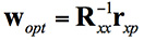
Taking the minimum and rearranging this leads to the well-known Wiener equation:
Figure: Michael Jones
This Wiener equation is the one to remember. It says that the optimum weights can be found by taking the inverse of the data covariance matrix, and multiplying it by the vector of cross correlations between the primary and auxiliary antennas. As in any adaptive signal processing problem, a simple way to solve the Weiner equation and get the weights might be to use your favorite gradient descent algorithm, such as least mean squares (LMS):
Figure: Michael Jones
However, a solution using this approach does have its problems, for reasons beyond the scope of this article. The mathematics of beamforming are also bit more involved, so I’ll leave that out here.
Rather than the grossly simplified diagram used here, most decent CRPAs also use a more complex architecture based on space-time adaptive processing (STAP) or space-frequency adaptive processing (SFAP). This generally allows much higher levels of jammer cancellation against a wider range of threats.
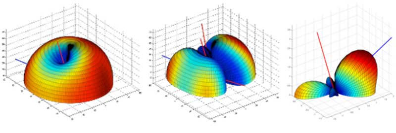
To finish off this whirlwind section on CRPA basics, let’s see what some example antenna gain patterns might look like. In the figures below, the blue line represents the direction of arrival of a GNSS satellite signal, whilst the red lines indicate the direction of arrival of a jammer. In the first diagram we have a single jamming signal: the antenna gain pattern is a nice hemisphere, as we would generally like, but there is a nice deep null in the direction of the jammer. Moving on to the next diagram, we can see the effect of having three simultaneous jammers on the same CRPA: again we have nice deep nulls in the direction of each jammer, but we are starting to lose more of the sky, and we may start to lose the odd satellite as a consequence. Finally, we have an example of beamforming on a single satellite, whilst nulling out a jamming source.
Again, it’s beyond the scope of this article, but the layout of the antenna elements plays an enormously important part in the performance and behavior of the CRPA.
Figure 4. Illustrative beam patterns of a CRPA antenna in the presence of jamming. (Figure: Michael Jones)Figure 4: Illustrative beam patterns of a CRPA antenna in the presence of jamming (Figure: Michael Jones)
Operational Anti-Jam Units
With some images courtesy of my friends at Raytheon, let’s look at a few examples of deployed military CRPA hardware over the years.
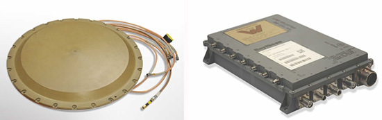
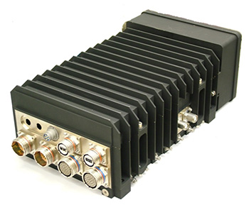
The GAS-1 system entered service in the U.S. in 1997, as a replacement for the earlier AE-1 (1990 to 1996). The CRPA is composed of two parts: the antenna array, which is a seven-element layout, and the antenna electronics as a separate box. The GAS-1 was incredibly successful and became the de facto standard anti-jam technology, fitted to air and sea platforms around the world. Even today, 20 years after its launch, it continues to be fitted to many platforms.
Figure 5. GAS-1 CRPA. (Photo: Raytheon)
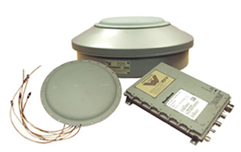
By the late 1990s and early 2000s, the Navigation Warfare (NAVWAR) program was in full swing, and the military was looking for enhanced protection against evolving jamming threats. The U.S. initiated a program called Advanced Digital Antenna Production (ADAP). The ADAP product, launched in 2006, was a direct form-fit replacement for the analog GAS-1 system, and introduced a number of advanced features. Most notably, the ADAP simultaneously protects both the L1 and L2 frequency bands, and utilizes STAP processing to achieve high levels of wideband jammer cancellation.
Figure 6. ADAP Digital CRPA. (Photo: Raytheon)
In parallel with the ADAP development, the Digital Antenna Control Unit (DACU) was different in a number of ways. Firstly, it was a true beamforming solution, allowing simultaneous antenna beams to be steered toward satellites, whilst simultaneously nulling out jammers.
Secondly, it was tightly integrated with the GPS receiver, with the GPS receiver hardware located in the same unit.
Thirdly, the DACU was able to perform a number of other advanced functions, such as direction-finding of interference sources. Interestingly, the DACU was used to help locate the source of the interference at the notorious Newark airport jamming incident in 2009.
By the mid-2000s, CRPA electronics were pretty mature and well-understood. The electronics had been miniaturized, and pretty much everything was put onto a single chip. But the physical size of the antennas persisted as a problem for some platforms requiring low size, weight and power (SWAP).
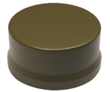
The Landshield, launched in 2014, was a step-change in CRPA technology. Not just because it was a small and fully self-contained unit (about the size of a hockey puck), but because it was the world’s first CRPA to include true anti-spoofing capability.
Figure 8. Landshield Advanced CRPA with Anti-Spoof Technology. (Photo: Raytheon)
Blurring the lines between military and civilian
Going back a few years, the military was heavily focused on CRPAs and anti-jam techniques in general. Military GPS receivers had been developed and deployed, and the question was how they could retrofit robustness to them. At the same time, the commercial world was heavily focused on mass-market GPS receivers — reducing cost, increasing performance — with little care about jamming.
If you’d talked to me five or six years ago, I would have said the military sector is 20 years ahead of the commercial sector in anti-jam technology, and the commercial sector is 20 years ahead of the military sector in receiver technology.
This assertion holds far less true these days; the lines of separation are much more blurred. The military is learning from the commercial world, embracing COTS, and developing new GNSS receivers. Conversely, civilian applications are now much more concerned with jamming, leading to the adoption of low-cost CRPAs in non-military applications.
The future of the CRPA
Where will CRPA technology go from here? We’ve already seen that the latest generation of CRPAs now performs anti-spoofing, as well as anti-jamming. But there is plenty more to see yet.
Although the core technology behind CRPAs is now mature, the trend for the future will be about “doing more with less.” CRPA technology will become more of a multi-function system. Military platforms need to cut down on the number of separate systems they install, and so CRPAs are likely to become multi-functional, performing situational awareness and signals intelligence.
As antenna technology progresses, we will likely see protected navigation solutions utilizing the same hardware as communication systems and radar systems, providing CESM and RESM functions, and being part of an integrated electronic warfare suite. And conformal antennas will see a resurgence of interest for complex and space-constrained platforms.
A U.S. Congress hearing on March 29 focused on the vulnerability of satellite systems to strategic attacks, according to an article by The Hill. The GPS constellation in particular was discussed as critical to energy, telecommunications and finance sectors.
Experts and lawmakers expressed their concerns at the joint hearing between the House Homeland Security Committee and House Armed Services Subcommittee on Strategic Forces.
The Hill quotes William Sheldon, former commander of U.S. Air Force Space Command: “Many of us remember the tagline from the 1979 movie Alien: ‘In space, no one can hear you scream.’ From my perspective, apparently no one can hear you scream about space vulnerabilities either. Many have banged the gong since 2007, but 10 years of studies and policy debates have not produced tangible improvements in our space defense posture. If you know the armed burglar is on the front porch, you do not wait until he’s inside to take action.”
Retired military officials and a former deputy administrator for the Federal Emergency Management Agency were among those testifying.
GPS Source has received Global Positioning Systems Directorate security approval for its family of Selective Availability Anti-spoofing Module (SAASM)-based Host Application Equipment (HAE).
GPS Source announced security approval for the Enhanced D3 (ED3) and Enhanced FLO-G (E-FLO-G) with integrated SAASM receivers. The ED3 and E-FLO-G are upgradeable versions of the popular DAGR Distributed Device (D3) and are capable of distributing SAASM today, and M-code protected GPS data when implemented.
Enhanced DAGR Distributed Device by GPS Source.
GPS Sources’ family of PNT distribution products represents the most advanced, cost effective and comprehensive solution available on the market to support Department of Defense’s GPS modernization efforts. Moreover, the ED3 and the E-FLO-G bridge the gap between legacy systems deployed today and the C4ISR/EW architectures of the future.
“We understand the importance of designing products that comply with all GPS Directorate security requirements,” said Robert Horton, CEO of GPS Source. “This security approval makes it possible for the ED3 and E-FLO-G to be deployed by military forces without reservation. GPS Source is proud to be a key supplier of such important enablers to the warfighter and to be the provider of innovative military GPS solutions to our defense customers.”
“Integrating legacy equipment utilizing SAASM receivers with future equipment relying on M-code receivers is challenging,” Horton continued. “But through Independent Research and Development, GPS Source ensured the ED3 and E-FLO-G integrate appropriately with SAASM today and M-code in the future. These accomplishments exemplify the technology in development by GPS Source to sustain the equipment that warfighters will employ today and tomorrow.”
GPS Source has begun taking orders for the ED3 and GLI-FLO-G. Production will start mid-year. Questions about this technology can be directed to Kurt Williams, director of Sales and Marketing.
DroneDeploy, a cloud software platform for commercial drones, is integrating with agX to help growers more easily capture field maps and analyze aerial data.
agX users can now share field boundaries saved in agX with DroneDeploy to simplify the planning of drone mapping flights. Over time, agX and DroneDeploy plan to integrate further to allow seamless sharing of drone images from DroneDeploy to agX.
“This integration will provide agX users an efficient method of combining high-quality UAV [unmanned aerial vehicle] imagery from DroneDeploy with other agronomic data to assist in decision-making that can add to a grower’s bottom line,” said Shawn Peterson, business development lead at agX. “Integrating quality imagery into an operation brings tremendous value by showing the varying conditions of the crop throughout the field. We are excited DroneDeploy will join the platform to offer imagery solutions that bring value to UAV applications.”
agX users can exchange field boundaries between DroneDeploy and other agX Compliant applications, allowing them to centrally store, access and share field boundaries. In the future, DroneDeploy’s integration will offer users the ability to share field data and imagery layers.
DroneDeploy makes drones accessible and productive tools that help growers save time and create actionable insights. Using DroneDeploy, a grower can automatically fly and capture drone imagery, create a field map and analyze crop variability in hours to help make timely management decisions.
“DroneDeploy makes it fast and easy for growers to capture aerial data,” said Scott Lumish, vice president of business development at DroneDeploy. “Integrations with tools like agX help growers turn that data into action.”
agX helps growers and service providers stay connected to various precision agricultural applications. Users can access and share their data within agX Compliant applications to save time and reduce duplicate data entry. Anyone can create a free agX account.
Support for DroneDeploy imagery transfer will be added to agX in early of summer 2017.
The European Satellite Navigation Competition (ESNC) — the largest international competition for the commercial use of satellite navigation — is once again in search of outstanding ideas and business models for accelerating Galileo applications.
Renowned institutions and regional partners are set to award prizes worth a total of more than €1 million in more than 20 categories.
Submissions are due June 30.
Innovation Network for Satellite Navigation
Satellite navigation is indispensable when it comes to accurate, reliable and continuous localization, according to the ESNC. This technology is fundamental to a variety of current trends, including multimodal logistics, the Internet of Things (IoT) and machine-to-machine (M2M) communication, unmanned aerial vehicles (UAVs) and smart cities.
First held in 2004, the ESNC has evolved into the leading innovation scouting mechanism in terms of Galileo-related applications across Europe and beyond. Moreover, the ESNC promotes the transformation of groundbreaking business ideas into market-ready products and new ventures.
Each year, the competition offers advantages to more than 400 business ideas. It has awarded prizes to more than 300 winners, which represent just a fraction of the 3,700 innovative concepts submitted by 11,000 participants. Through its network — including the ESA Business Incubation Centres, other incubators across Europe and the new E-GNSS Accelerator co-funded by the European Commission — the ESNC plays a decisive role in the realization of promising ideas by supporting the foundation of startups and creating high-tech jobs.
One of the main objectives of the ESNC is fostering the European space sector’s competitiveness globally by boosting the development of commercial space applications, especially for startups, SMEs and young entrepreneurs. Advancing Europe’s space programs and meeting user needs, especially when it comes to space data access to encourage alternative business models and technological progress, represent major goals of this strategy.
The involvement of the pan-European spirit within the EU Space Strategy is realized in the ESNC by engaging multiple regions across Europe with their own dedicated prizes.
“The investment in space technologies and applications as well as the support of forward-thinking entrepreneurs and startups ensure Europe’s increased competitiveness,” said Elżbieta Bieńkowska, commissioner for internal market, industry, entrepreneurship and SMEs. “To achieve this ultimate goal, the European Satellite Navigation Competition (ESNC) and the Copernicus Masters are a proven platform for trendsetting technologies and business models based on Galileo and Copernicus to implement the new EU Space Strategy.”
Within this context, this year’s ESNC patronage taken over by Markku Markkula, president of the European Committee of the Regions (CoR), sets the tone for the innovation competition’s pan-European mission of uniting the European regions and cities through the support of space-related businesses and future-oriented entrepreneurs, increasing the market and user uptake of Galileo.
“The European Committee of the Regions attaches great importance to the new opportunities linked to the involvement of European regions in innovation networks, such as the European Satellite Navigation Competition,” Markkula said. “I have therefore gladly taken on the role of patron for the ESNC as of 2017.”
E-GNSS Accelerator
As the high-tech platform for pioneering satellite navigation applications, the ESNC is now additionally equipped with the new E-GNSS Accelerator. This program is a unique opportunity for entrepreneurs and startups to accelerate their business case on a broad scale and bring their products and services to market.
The E-GNSS Accelerator will run for three years and will directly support the winners of the ESNC 2017, 2018 and 2019. Thereby, the participants await even more prizes, services and three further business incubations worth an additional value of EUR 500,000.
ESNC Partners
In the ESNC 2017, special prizes are to be offered in partnership with the following institutions: the European GNSS Agency (GSA), the European Space Agency (ESA), the German Aerospace Center (DLR), and the German Federal Ministry of Transport and Digital Infrastructure (BMVI).
Prototypes can also be entered into the GNSS Living Lab Challenge.
The University Challenge, meanwhile, is explicitly designed for students and research associates.
In addition, participants choose from this year’s confirmed partner regions: Asia, Austria, Baden-Württemberg / Germany, Basque Country / Spain, Bavaria / Germany, Catalonia / Spain, Estonia, France, Hesse / Germany, Ireland, Madrid / Spain, The Netherlands, Norway, Poland, Romania, United Kingdom, and the Valencian Community / Spain.
Stay tuned for more updates on additional ESNC regions.
Obtain more information at the official website, www.esnc.eu, comprising all relevant information on prizes, partners, and terms of participation involved in the ESNC.
Prizes for the Best Applications
This year’s winners will take home prizes worth a more than EUR 1 million and be welcomed into the ESNC’s leading innovation network for global satellite navigation systems.
Along with cash, the various prize categories offer primarily technical, business-related and legal support in realizing the winning business models. A jury of international experts from the realms of research and industry will also evaluate the winners of all the categories to select an overall winner, who will be revealed at the festive Awards Ceremony in early November 2017.
Furthermore, three additional incubations, supported by the European Commission, will be awarded in front of a high-ranking audience.
Those who enter the ESNC also stand to benefit greatly from the opportunity to work closely with leading institutions and regional partners. The ESNC is geared towards individuals and teams from companies, research facilities and universities around the world.
Awards Ceremony and Space Conference
A partner program, the Copernicus Masters (Earth observation), also kicked off on April 5 in Brussels.
The Awards Ceremony for both the ESNC and the Copernicus Masters takes place in early November. The event brings together industry, politics, entrepreneurship and research to showcase the most disruptive space applications and discuss trendsetting developments in the satellite downstream sector and its various application fields.
Sierra Wireless is leveraging a broad suite of 3G/4G connectivity solutions from Skyworks Solutions to power its AirPrime HL Series of wireless modules targeting machine-to-machine (M2M) and device-to-cloud applications, according to Skyworks.
In total, Sierra Wireless is making use of 17 Skyworks devices spanning high-performance multimode, multiband power amplifiers, transmit/receive front-end modules, RF switches and DC-DC converters.
With the integration of Skyworks’ devices, Sierra Wireless’ modules combine voice and connectivity functionality that can be deployed in any region and on any wireless mobile network.
“By partnering with market leaders like Sierra Wireless, Skyworks is diversifying into new, fast-growing markets across the Internet of Things (IoT),” said Carlos Bori, vice president of sales and marketing for Skyworks. “Our unique connectivity portfolio and integration capabilities enable us to solve our customers’ challenges and deliver efficient, scalable solutions.”
“Sierra Wireless’ HL Series modules provide unprecedented scalability between networks,” said Dan Schieler, senior vice president and general manager, OEM Solutions, Sierra Wireless. “By leveraging Skyworks’ analog and RF expertise, we are able to support various data rates, enable global coverage and offer industrial-grade solutions for OEMs who are looking to standardize connectivity across multiple products and markets.”
According to a GSMA Intelligence report, at its current rate of trajectory, global cellular M2M connections are forecast to reach close to one billion by 2020, growing at a 25 percent per year compound annual growth rate from 2015 to 2020.
Leica Geosystems has introduced the Leica Zeno GG04 smart antenna, enabling a flexible solution to improve mobile devices’ GNSS accuracy with real-time kinematic (RTK) and precise point positioning (PPP).
Paired with the Zeno GG04, any Zeno or third-party mobile device with Android or Windows OS can now collect highly precise positioning data with Leica Geosystems’ GNSS technology and 555-channel tracking performance. With PPP, users can collect data in areas without cellular coverage. The bring-your-own-device (BYOD) functionality enables any smart device to collect survey-grade data, delivering centimeter results.
“We’re excited to hear about the new Zeno Connect for Android. Being able to connect any Android device to the new GG04 antenna and use it for field data capture is a real game-changer,” said Zenny Chareas, project manager at PeopleGIS, a firm that builds web-based database applications for field collection currently using the Leica Zeno GG03. “Our clients have been eagerly anticipating this type of functionality, and it’s pretty cool that we now have a solution for them.”
With the Zeno Connect app, any third-party app is compatible with the Zeno GG04 smart antenna. The Zeno Mobile, Zeno Connect or Esri’s Collector for ArcGIS apps provide an easy and familiar platform for non-surveying professionals to collect and analyze data. Organizations can integrate and enrich data in real time from different sources to collect all details of any project from anywhere in the world, regardless of how remote.
“Wherever users are working, despite, how rough the environment, the Zeno GG04 ensures all needed data is easily and accurately collected,” said Alexander Fischer, Leica Geosystems Zeno product manager. “The flexibility offered by turning our most common devices into precise instruments increases access to the geopositioning world, and this is certainly an exciting advancement to share technology and information with new segments.”