The Ribble River flowing through Preston in Lancashire, United Kingdom, has hidden depths.
“The challenge with rivers is that much of the beauty and interest is hidden from view beneath the surface,” said Jack Spees, CEO of the Ribble Rivers Trust. “To reveal this beauty, we undertook a bathymetric survey of a section with particularly interesting features that is adjacent to a heavily used public footpath.”
The trust is using survey results to reveal these hidden depths on interpretation boards, including digitally augmented reality and video media enabling visitors to explore the underwater world.
For the survey, a robotically controlled 1.2-meter twin-hull shallow draft vessel powered by a twin-jet system surveyed a hectare of the riverbed. It carried depth-recording sonar and a tracking prism that enabled a Spectra Precision Focus 35 total station to lock onto and robotically follow and record the vesssel’s location.
Echo soundings were transmitted to a tablet PC ashore via long-range Bluetooth and time stamped, while the boat’s position was continuously recorded by the total station and sent back to a tablet PC, also using long-range Bluetooth and time stamped.
The tablet PC ran 4Site, a program that formatted and processed the data from the sonar and the total station into a DWG drawing. Each point was positioned in real time, so the vessel operator could ensure complete coverage. A mesh of a 200-meter section of the river with depths to 3.5 meters was combined with aerial lidar data to produce the survey.
Sonardyne Inc. has supplied acoustically aided inertial navigation technology to McDermott International for its Lay Vessel 108 (LV 108). McDermott is an offshore engineering, procurement, construction and installation company.
The Ranger 2 Pro DP-INS system, the highest specification available from Sonardyne, is being used to support touchdown monitoring surveys of submarine cables, umbilicals and pipelines and as an independent position reference for the LV 108’s Kongsberg dynamic positioning (DP) system.
McDermott’s Lay Vessel 108. Photo: McDermott
McDermott’s LV 108 entered service in 2015 and is on contract in the Ichthys field, Western Australia. Designed as a fast-transit, dynamically positioned (DP 2) vessel for subsea constructions support across a wide variety of water depths, the LV 108 has 21,528 square feet of deck space and can accommodate a crew of 129.
Dynamically positioned construction and installation vessels such as the LV 108, conventionally rely on ultra-short baseline (USBL) acoustics and the GNSS as their primary sources of position reference data.
However, a vessel’s station-keeping capability can be compromised in the event the USBL is affected by thruster aeration and noise and the GNSS signal is simultaneously interrupted. The latter is particularly common around equatorial regions and during periods of high solar radiation.
Sonardyne’s Ranger 2 Pro DP-INS system addresses this operational vulnerability. It aids vessel positioning by exploiting the long-term accuracy of Sonardyne’s Wideband 2 acoustic signal technology with high-integrity, high-update-rate inertial measurements. The resulting navigation output has the ability to ride-through short-term acoustic disruptions and is completely independent from GNSS.
In addition to the system’s deep-water positioning performance and safety benefits, DP-INS has been proven to deliver valuable time and cost savings for vessel owners. It does not need a full seabed array of transponders to be installed and calibrated before subsea operations can commence. For most subsea tasks, positioning specifications can be met with only one or two transponders deployed on the seabed.
Additionally, as the system needs only occasional aiding from the acoustics, transponder battery life is substantially increased and the need to task a remotely operated underwater vehicle (ROV) to deploy and recover transponders for servicing is reduced.
The equipment supplied to McDermott for the LV 108 included Sonardyne’s INS sensor co-located with the company’s sixth-generation (6G) HPT acoustic transceiver. This hardware was installed on one of the vessel’s two Kongsberg through-hull deployment machines and interfaced directly with the vessel’s DP system, also supplied by Kongsberg.
For nearly two decades, SPAR 3D has been the premier vendor-neutral event for the application of 3D technology in industry. But the surge in innovation and commercial uses for 3D technologies has brought opportunity for expansion.
In 2017, SPAR 3D will highlight cutting-edge innovation in 3D technologies from input to output, covering 3D sensing, 3D processing and 3D visualization tools. The expo and conference will take place April 3-5 in Houston, Texas.
In the exhibit hall, new products and hands-on demonstrations will be showcased.
Because of the uncanny timing and convergence of global market conditions, technology innovation, social wants and government needs, a smart cities market has exploded on a global scale that dwarfs any previous notion of the value given to the built environment.
Sometimes described as part of Big Data or the Internet of Things programs, Smart City initiatives being implemented in many urban environments around the world today require accurate and authenticated data in which to work properly, but require 3D data generation and display innovations.
Doherty will explore trends, solutions and implementations from greenfield and existing Smart Cities real estate developments from China, Australia, Saudi Arabia and the United States. He will explore the market-making abilities of Smart Cities that are developing solutions using 3D and UAVs, as well as the emerging privatization of outer space.
Sessions
Sessions will cover:
Big Data and Working in the Cloud
Wearables
AR/VR
3D Printed Buildings
3D Technology in AEC
Autonomous Vehicles
Market-specific sessions will focused on the end-to-end application of 3D tools.
Also, an “Intro to 3D Technology” track for professionals new to 3D will be offered.
For nearly two decades, SPAR 3D has been the premier vendor-neutral event for the application of 3D technology in industry. But the surge in innovation and commercial uses for 3D technologies has brought opportunity for expansion.
In 2017, SPAR 3D will highlight cutting-edge innovation in 3D technologies from input to output, covering 3D sensing, 3D processing and 3D visualization tools. The expo and conference will take place April 3-5 in Houston, Texas.
In the exhibit hall, new products and hands-on demonstrations will be showcased.
Because of the uncanny timing and convergence of global market conditions, technology innovation, social wants and government needs, a smart cities market has exploded on a global scale that dwarfs any previous notion of the value given to the built environment.
Sometimes described as part of Big Data or the Internet of Things programs, Smart City initiatives being implemented in many urban environments around the world today require accurate and authenticated data in which to work properly, but require 3D data generation and display innovations.
Doherty will explore trends, solutions and implementations from greenfield and existing Smart Cities real estate developments from China, Australia, Saudi Arabia and the United States. He will explore the market-making abilities of Smart Cities that are developing solutions using 3D and UAVs, as well as the emerging privatization of outer space.
Sessions
Sessions will cover:
Big Data and Working in the Cloud
Wearables
AR/VR
3D Printed Buildings
3D Technology in AEC
Autonomous Vehicles
Market-specific sessions will focused on the end-to-end application of 3D tools.
Also, an “Intro to 3D Technology” track for professionals new to 3D will be offered.
Agribotix, drone-enabled agricultural intelligence, has partnered with senseFly, producer of professional fixed-wing drones, to offer a new combined solution optimized for the early identification and troubleshooting of crop issues.
It combines the eBee SQ — senseFly’s advanced, long-range agricultural drone — with Agribotix’s FarmLens cloud-processing platform to make collecting and analyzing aerial data easier, with more coverage per flight than is possible with most quadcopter solutions.
By adopting the eBee SQ as its new fixed-wing drone platform, Agribotix is signaling its ongoing commitment to sourcing the best hardware on the market to bundle with its award-winning FarmLens SaaS platform, a 100-percent agricultural data-processing cloud solution.
The eBee SQ is built around Parrot’s Sequoia sensor, which features multispectral sensors that capture calibrated data across four highly distinct spectral bands (near-infrared, red-edge, red and green), plus RGB imagery, in a single flight.
The FarmLens Professional subscription now being bundled with the eBee SQ gives users the ability to perform the full crop scouting workflow in the field: fly large areas efficiently, capture ground truthing images, make notes, and share detailed information about trouble spots with farmers from the field. FarmLens users gain valuable insights about crop conditions without having to become experts in data processing.
“The combined solution of the eBee SQ and FarmLens is a great fit for people who are looking for a simple, yet powerful, 100-percent agricultural solution,” said Lou Faust, Agribotix CEO. “After evaluating the fixed-wing options available today, there was no question that the eBee SQ is the easiest to use long-range drone on the market. It also has the best-in-class agricultural sensor, while FarmLens does the heavy lifting in the background, returning superb quality data presentation via the Agribotix Digital Scouting Report and enabling farmers to make time-critical adjustments.”
“We’re delighted to join forces with Agribotix in pairing the eBee SQ with FarmLens,” said Jean-Christophe Zufferey, senseFly’s CEO. “This partnership creates a professional end-to-end solution that is uniquely easy to use.”
Once the combined solution is purchased, customers will receive full professional hardware support via senseFly’s network of expert distribution partners.
Professional GNSS users now expect lightweight, easy-to-use receivers optimized for their particular workflows. Meanwhile, a streamlined manufacturing process means design and production of sophisticated instruments now takes months rather than years, and relies on global teams of networked specialists.
Carlson Software approached Hemisphere GNSS in early 2015 with the goal of bringing a new GNSS receiver to market, one optimized for land surveyors with high precision, convenience, and small form factor. “We work closely with land surveyors, and we definitely saw a need,” said Carlson’s director of special projects Karl Nicholas. “Our clients were asking for smaller, lighter receivers. We also felt that a new receiver could be better optimized to work with the multiple satellite constellations now available, and with the array of RTK solutions that surveyors use routinely.”
Hemisphere recognized that a new lightweight receiver would also serve its own marine clients well, especially if it was optimized to work with the company’s Atlas GNSS Global Correction Service as both rover and base station.
The S321 by Hemisphere GNSS. Photo: Hemisphere
Carlson focuses on computer-assisted design (CAD) software, field data collection, and machine control products for land surveying, civil engineering, construction, and mining. Through the partnership, Hemisphere gained access to a deep knowledge base of how surveyors work with GNSS in real-world conditions, and how to optimize a new receiver for fieldwork of all kinds.
This aided decisions about interface, form factor, and features. Project dialog between the two companies identified specifications for particular functions and features, as prototypes became available for testing and feedback.
Specifications included:
Compact and Durable. A form factor for a smaller receiver had already been developed. “Our hardware design and manufacturing division in China presented a hardware design that we really liked, so we didn’t have to redesign from scratch in that area,” explained Hemisphere senior product manager Lyle Geck. “We were able to move ahead with only minor modifications.”
Carlson tested rigorously before signing off on the hardware design. “I put mine on top of a two-meter pole and dropped it onto concrete and dirt, and I also tried it out in wet weather — worked fine!” recalled Nicholas.
Multiple Constellations. “We now have a receiver that works seamlessly right now with GPS, GLONASS, and the Chinese BeiDou system,” added Nicholas. “And when Europe’s Galileo system becomes available, we’ll be ready for it too.”
RTK, Correction Sources. Hemisphere’s Athena RTK engine, is designed to process the new signals with high-accuracy performance. In addition to traditional RTK correction methods using NTRIP and UHF/900 MHz radios, Hemisphere also provides Atlas, its own L-band correction service: subscription-based, flexible, available over the Earth’s landmass, from approximately 200 reference stations, providing up to sub-decimeter accuracies via L-band satellites or over the Internet.
The new receiver was also designed with a built-in UHF radio, and multiple wireless communication ports to enable corrections via radio, cellular modem, Wi-Fi, Bluetooth, or serial connections.
Base Station Capacity. The receiver can serve as both rover and base station. “For our marine clients, this receiver is actually more likely to be used as a base station,” said Geck, typically set up in a port for construction or other maritime operations. Not a closed system, it works with Atlas, other protocols like TrimTalk, and with external radios that can be connected as needed.
Productivity. For surveyors, Carlson specified a compass and a tilt sensor so the receiver knows if the pole is vertical, how it’s oriented horizontally, and how to correct for those factors. It works for stakeouts and recovering points; the unit directs the user to the next point graphically, saving time.
For surveyors in obstructed areas, position reliability will often degrade. “Surveyors are aware of this, but it’s hard to compensate when they don’t have information about just what’s happening with accuracy.” SureFix uses proprietary algorithms and various inputs to give a quality indicator for particular points, for confidence when shooting in difficult multipath conditions, or telling a surveyor to slow down to get the required precision. This improves fieldwork and can eliminate trips back to the field to correct errors.
Carlson Software leveraged its 30+ years in land surveying, while Hemisphere GNSS added manufacturing experience and GNSS and RTK expertise. The result is a compact receiver, BRx6 from the former and S321 from the latter, tuned for the requirements and workflows of customers’ daily projects.
The Dutch state-owned rail company NS Groep N.V. is deploying a real-time remote diagnostics monitoring system. As a core component of NS’ overall real-time monitoring architecture, the system allows railway operators to streamline maintenance costs and provide efficiencies across their fleet by automating manual tasks.
NS in the Netherlands will join a growing number of large rail operators that have implemented GNSS solutions, in this case the Trimble R2M system. Others using R2M include South West Trains in the United Kingdom, Irish Rail, SNCF France, SBB Switzerland and VR Finland.
R2M processes diagnostic data from rail vehicles in real time. It provides a comprehensive view of the overall fleet’s status including specific vehicle faults. The system also identifies potential faults that may arise while analyzing and detecting anomalies in on-vehicle component behavior to identify component issues and the possible impact this behavior may have on the vehicle and overall fleet.
With the R2M software, NS will be able to aggregate data from a range of on-train and wayside sources and provide real-time information to the NS Train Helpdesk to monitor the fleet status. Information will also be available to fleet analysts, work-planning engineers and mechanics to support the operational repair process of NS in real time.
BlueBird Aero Systems has won a contract to supply a target variant of an unmanned air vehicle to the Israeli Air Force (IAF), to enable it to train its air defense units.
The IAF selected BlueBird’s ThunderB after it completed a series of test flights in which it reached a speed of 150 kilometers per hour and a ceiling of 15,000 feet.
The target version of the ThunderB will carry a simple optical payload.
The ThunderB is a small-sized tactical UAV (28 kilograms, 4-meter wingspan), with intelligence, surveillance, target acquisition and reconnaissance (ISTAR) capabilities previously found only in much larger UAVs, usually with weight of above 200 kilograms. It is suitable for ISTAR because of its long endurance capability (6–24 hours), its extended control range and its cooled/uncooled infrared and optional laser pointer payload.
The World Meteorological Organization (WMO) announced the highest wave on record: a behemoth that towered 19 meters (62.3 feet, or about five building storeys) above the North Atlantic. Examination of data sent by an automated buoy showed the monster wave rose on Feb. 4, 2013, at a remote spot between Britain and Iceland.
The mighty wave occurred after a strong cold front came through the area, producing winds up of 43.8 knots (81 kilometers, 50.4 miles per hour). The previous record height for a wave was 60 feet in December 2007, also in the North Atlantic.
Automated buoys are vital tools for oceanographers, sending back data on sea currents, temperatures and swells for seafarers, climate researchers and others. Many buoys are GPS-equipped to measure water height. We suspect this one was, though it has not been confirmed. GPS World carried a story about NavCom GPS-equipped ocean buoys in May 2006.
The North Atlantic, from the Grand Banks underwater plateau off Canada to south of Iceland and west of Britain, is the world’s biggest breeding ground for giant waves.
Details of the new record and definition of significant wave height are available here.
The next GPS World webinar will discuss signal interference in product development and integration, from board-level GNSS receivers to system-level GNSS receivers in different application platforms. Register at no-cost for “Signal Interference: Detection and Mitigation,” which will be held at 1 p.m. EST (10 a.m. PST, 7 p.m. CET) on Feb. 2.
As the number of GNSS signals being tracked increases, so does the potential for interference to dismiss the performance gains of using those additional signals. To maximize performance and efficiency, prepared PNT users need their equipment to be able to detect when interference is present and mitigate it.
Developers, integrators and users need mitigation tools to protect and preserve GNSS measurement quality, maintaining high-quality multi-frequency multi-constellation positioning performance even in challenging RF environments. This is essential particularly on the integration journey, especially during prototyping and when encountering unforeseen interference events in field testing, in order to produce fully successful integrated products.
Patrick Casiano of NovAtel’s Applied Technology Group will speak on this topic, and other speakers to be announced. GPS World Editor-in-Chief and Publisher Alan Cameron will moderate.
Casiano has responsibility for NovAtel’s Applied Technology Group with a mandate to test and evaluate the strengths of products, both proprietary and competing, through tests in vertical segment-specific use contexts. He has led the development of unique projects on single-board computing platforms and integration of mobile IP technology for remote monitoring; streamlined recurring test methodology templates; and applied user experience and customer principles to create specific targeted content to customers in particular phases of their product integration.
The one-hour webinar also will include a follow-up Q&A session with the speakers.
Virtual Halo is a new personal protection app for the iPhone and Apple Watch, aimed at increasing safety around the world.
Photo: Virtual Halo.
The app has three key features.
SOS is designed as a personal panic button. When pressed in the iPhone app or on the Apple Watch, an emergency notification is sent by the Virtual Halo cloud to the user’s emergency contacts, providing the nearest street address and a link to the user’s location on their map.
The Check In feature lets emergency contacts know the user is OK; optionally, the user can include a custom message and location.
With the Going Out feature, adventure sports enthusiasts let the app know their intended destination and when they’ll be back. If they don’t disable the app by their preset time, the Virtual Halo service sends a text to their emergency contacts letting them know the user went out, the activity they were participating in, that they expected to be back by the specific time and that they haven’t returned; it also provides the user’s last known location.
New cars for the Russian market must be equipped with the automatic ERA-GLONASS emergency call system.
For certification of these in-vehicle systems, both conformance and performance tests are mandatory, in line with the Russian GOST R 55534 specification.
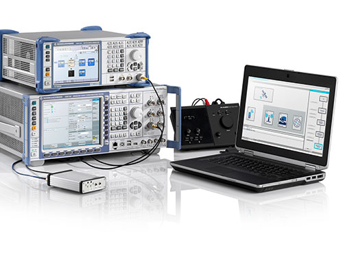
The Rohde & Schwarz CMW500 is being used to test the ERA-GLONASS system.
For both types of tests, the Russian Certification Center Svyaz-Certificate uses standard-compliant test solutions from Rohde & Schwarz. Manufacturers and component suppliers can use the same test solution in pre-tests to speed up certification for their products.
Now, for the newly required performance test, the center is using the GNSS simulator in the R&S SMBV100A vector signal generator.
Accuracy Requirements. During performance testing, it is verified whether the GNSS receiver of an ERA-GLONASS emergency call system fulfills the accuracy requirements of the specification.
In case of an emergency, the call system should not only correctly transmit position data according to a specified protocol to the public safety answering point, but position data must also be accurate so that the first responder can locate the accident vehicle quickly.
ERA-GLONASS module manufacturers and test houses can use the R&S SMBV100A during pre-tests to create reliable and reproducible conditions similar to those in official certification tests, according to Rohde & Schwarz, to minimize the risk of failing tests during certification.