Category: Applications

  • Hemisphere GNSS names new president and CEO

    Farlin Halsey has been named president and chief executive officer of Hemisphere GNSS, effective Jan. 2, 2017. He replaces Xinping Guo, interim president and CEO. Halsey has also been appointed to the Hemisphere board of directors, where Guo will continue to be a member.

    With more than 25 years of executive leadership experience in the high-technology electronics industry, Halsey brings a wealth of knowledge and expertise to Hemisphere, according to a company statement. Serving in a range of executive officer and senior management capacities, he has extensive proven experience in GNSS OEM sales market segments including construction, agriculture, survey and mapping, GIS, automotive, personal (mobile) navigation, handheld devices, application software, and electronic components and modules.

    Before joining Hemisphere, Halsey’s executive leadership positions included president and CEO of RF Monolithics,  a designer and manufacturer of wireless connectivity products used in integrated circuits, certified modules and machine-to-machine applications. He facilitated the sale of the company to Murata Manufacturing Co. Ltd., where he most recently served as vice president of strategic marketing for Murata Electronics Americas.

    Previously, Halsey held executive positions at NovAtel, Inc., including vice president of corporate strategy and alliances and vice president of marketing — roles in which he was instrumental in the acquisition and integration of several companies, as well as developing the company’s successful OEM business strategy. He later played a key role in positioning the company prior to its successful sale to Hexagon AB. Among other roles preceding his executive leadership at NovAtel, Halsey held several marketing and sales management positions at Topcon Positioning Systems, Inc. for the North American market.

    “Throughout his career, Farlin has repeatedly demonstrated the ability to develop key corporate strategies to increase a company’s scale and enable it to grow globally,” said Werner Gartner, chairman of Hemisphere’s board of directors. “His understanding of our business, significant international experience, and deep OEM and GNSS industry expertise make him ideally suited to lead Hemisphere as we look to enter the next phase of our growth and development.”

    “Hemisphere has long been recognized for its pioneering and trend setting high-precision GNSS technology, and I look forward to leading the company’s talented team as we make the strategic decisions necessary to expand our market share and OEM presence globally,” Halsey said. “Leveraging our rich GNSS experience and strong, core GNSS technologies, along with UniStrong’s manufacturing resources, means that Hemisphere is poised for significant global growth.”

    Gartner added, “In conjunction with Farlin joining our company, we thank Xinping Guo for his leadership and guidance as Hemisphere’s interim president and CEO for the past eight months while we conducted an extensive executive search.”

    As chairman and general manager of Beijing UniStrong Science & Technology Co. Ltd., which owns 100 percent of Hemisphere GNSS Inc., Guo will continue to be a member of the Hemisphereboard of directors.

  • Teledyne Optech launches static, mobile surveying solutions at Intergeo 2016

    Teledyne Optech launched survey instruments and workflow solutions for collecting 3D spatial data at Intergeo 2016, which was held Oct. 11-13 in Hamburg, Germany. General Manager Michel Stanier highlights the Polaris terrestrial scanner, Maverick mobile scanner, Eclipse airborne sensor and Galaxy sensor.

  • New defense signals offered, new defense editor sought

    New defense signals offered, new defense editor sought

    Two important new signals — or rather, one signal and one group of signals — became available for military users worldwide last week. Satelles made an exciting announcement of what amounts to a new dimension in satnav: a whole new constellation in low-Earth orbit, bringing global coverage and most critically, a signal strength hitherto unknown to GNSS users. The satellite time and location (STL) has primary application in the timing realm, which is vital in many applications.

    Higher in the sky, Europe’s GNSS satellites constituting the Galileo system officially began offering their services, and the multiple frequencies available here mean robustness, greater availability in obstructed environments, and — some say, though this is controversial — greater positioning accuracy, largely through more precise timing onboard.

    Meanwhile, GPS World seeks a new defense editor for this column, and adopting the concept of “promoting from within,” now turns to its readership for interested parties to volunteer.

    A New SatNav That’s Not GNSS

    A strategic alliance announced on Dec. 15 between companies Orolia and Satelles includes will provide positioning, navigation and timing (PNT) solutions provided by the Iridium satellite constellation, independent of GPS/GNSS signals. The companies intend to provide PNT solutions to military, defense, government and commercial customers worldwide. Their new satellite timing and location (STL) service can supply much-needed robustness to GPS-dependent operations.

    Orolia, the parent of GNSS-active companies Spectracomm, McMurdo, and  Spectratime, has extensive experience in the defense realm. The company says it is #1 worldwide in the manufacture of military beacons outside the U.S. with a 60% market share, and #2 within the U.S., and that it is the first-ranked provider of Medium-altitude Earth Orbit Search and Rescue system (MEOSAR) worldwide.  In partnership with Satelles, it will provide the STL service independent from traditional GPS and other GNSS satellite signals. STL is reported to be less susceptible to vulnerabilities such as spoofing, interference and jamming that are associated with GPS/GNSS — and the stronger signal penetrates buildings where GPS/GNSS cannot reach.

    Iridium satellite, courtesy Iridium.

    Iridium satellite, courtesy Iridium.

    Based on the low-Earth orbit (LEO) Iridium satellite constellation, STL signals are up to 1,000 times stronger than GPS/GNSS; this signal strength, due in part to the constellation’s closer proximity to users, helps to prevent jamming and enables signal reach into buildings and other difficult locations. STL’s additional cryptographic security also enhances performance, productivity and security.

    For further background on Iridium, see the June 2016 Defense PNT column by Don Jewell,“Iridium and GPS revisited: A new PNT solution on the horizon?

    Projected key applications and use cases include energy/utility grids, enterprise data networks including financial systems, maritime/aviation navigation, fleet/asset tracking management, search and rescue and data center management.

    “The timing signal is very accurate and close enough to GPS for most timing applications, although the positioning accuracy is lower than what GPS users are used to,” said Orolia CTO Jean-Yves Courtois. “It is an augmentation for timing primarily, and secondarily for positioning.”

    “In terms of timing accuracy, it provides on the order of tenths of microseconds in accuracy, and this covers a lot of timing applications, very familiar to us and to our customers. This is an ideal timing backup or augmentation of GPS. As number 2 worldwide in high-precision timing, we know this market and its applications very well.”

    “In positioning it’s closer to fifty meters or more. Much better for fixed objects than for mobile objects. The more mobile, the faster the vehicle, then the lower the positioning accuracy. It’s not directly usable for GPS applications that require a few meters accuracy, but it can be associated with inertial navigation for much better results.”

    “The signal is encrypted, so you have to subscribe to a service to receive a key, allowing access to the signal. Applications are developing based on equipment that will be STL-enabled. For the user it will be transparent. The user will have a different antenna.”

    “We are also active in tracking and emergency location devices, where this is also of interest. It has some authentication capability, to guarantee that the person who accesses the signal is in the location that he pretends to be.”

    Galileo, live at last!

    Also on Dec. 15, the European Commission issued the Galileo Initial Services Declaration. The Declaration of Initial Services means that the Galileo satellites and ground infrastructure are now operationally ready. These signals will be highly accurate but not available all the time, since the constellation is not yet complete and users cannot always count on four satellites being visible at one time at all points on the Earth.

    Galileo has a significant role to play in military operations. It adds multiple frequencies to the GNSS palette, important for resistance to jamming. It adds satellites, and will add more in the new future, very important for signal availability.  And its Public Regulated Service (PRS) is specifically designed with special features for security, defense and military operations.

    I attended a GNSS Symposium recently in Australia where an academic expert repeated the oft-made assertion that Galileo is the only GNSS that is civil-designed and civil-controlled. At which point an industry expert leaned over, grabbed the microphone and growled “Yeah, right.”

    No matter how you look at it, Galileo add important benefits to GPS for  the suitably equipped warfighter.

    This Newsletter Enters a New Era

    Beginning in January 2017, this Defense PNT newsletter will combine with our GeoIntelligence Insider e-newsletter to offer broad coverage of both hardware and software matters, driven by GPS/GNSS, and enhancing the capabilities of security, defense, military and other government forces. Readers of both newsletters will receive the new combined edition as a matter of course.

    Many readers will know of  the recent passing of Don Jewell, the longtime editor of Defense PNT.  We must soldier on, and GPS World hereby extends an invitation to readers of this newsletter — many of whom, we know, are military experts in your own right — who may wish to volunteer to fill Don’s position.  Please write to [email protected] to request details, and please provide a brief outline of your background and experience.

    Until next time,

    Happy Navigating.

  • New SatNav offerings come to market via STL service

    Pursuant to a recent announcement of new PNT solutions independent of GPS/GNSS signals, provided via the Iridium constellation, GPS World talked with Jean-Yves Courtois, CEO of Orolia. Orolia has partnered with Satelles to bring new PNT products and services to the global market, with a focus on military, and defense, government and commercial customers worldwide.

    Jean-Yves Courtois, CEO of Orolia
    Jean-Yves Courtois, CEO of Orolia.

    “We are a manufacturer and integrator of timing equipment,” Courtois said. Orolia is the parent company of GPS/GNSS product and service providers Spectracom, McMurdo and Spectratime. “This new STL service is not fully commercialized yet, but it’s operational and it can be tested. Receivers are available and can be integrated into our equipment.

    “The timing signal is very accurate and close enough to GPS for most timing applications, although the positioning accuracy is lower than what GPS users are used to. It is an augmentation for timing primarily, and secondarily for positioning.

    “In terms of timing accuracy, it provides on the order of tenths of microseconds in accuracy, and this covers a lot of timing applications, very familiar to us and to our customers. This is an ideal timing backup or augmentation of GPS. As number 2 worldwide in high-precision timing, we know this market and its applications very well.”

    The STL signal strength is much greater than GNSS because the LEO satellites are much closer. (slide courtesy Satelles)
    The STL signal strength is much greater than GNSS because the LEO satellites are much closer. (slide courtesy Satelles)

    Because the signal providing the satellite time and location (STL) service emanates from low-Earth orbit (LEO) satellites, its strength is much greater than GPS and other GNSS signals. Among its key characteristics: it gets good reception inside buildings and beneath other obstructions.

    “The STL signal works very well,” Courtois continued. “We were surprised. Satelles is very conservative in their statements, and we got better results than they promised in our tests. They under-promised and over-delivered. It penetrates buildings well, it has unique features and it performs at a high level. So we decided to invest in it. All our engineers are excited about it!

    “In positioning it’s closer to fifty meters or more. Much better for fixed objects than for mobile objects. The more mobile, the faster the vehicle, then the lower the positioning accuracy. It’s not directly usable for GPS applications that require a few meters accuracy, but it can be associated with inertial navigation for much better results.

    “The signal is encrypted, so you have to subscribe to a service to receive a key, allowing access to the signal.

    “Applications are developing based on equipment that will be STL-enabled. For the user it will be transparent. The user will have a different antenna.

    “We are also active in tracking and emergency location devices, where this is also of interest. It has some authentication capability, to guarantee that the person who accesses the signal is in the location that he pretends to be.”

    “For customers to be able to use this service, there is some integration work to be done, some dedicated STL receivers to integrate into our current hardware set up, and software modifications. Our engineers are ready, we are all ready to work with government and defense organizations and other new clients.”

    “Our basic interest is to add some robustness to our equipment for our current customers, and then of course to develop new customers worldwide.”


  • Esri ArcGIS 10.5 helps make sense of real-time information

    Esri ArcGIS 10.5 helps make sense of real-time information

    Esri has released Esri ArcGIS 10.5, its next-generation analytics technology for innovative organizations.

    Organizations worldwide are challenged to make sense of real-time digital information. Esri ArcGIS 10.5 helps them glean insight from enterprise data, big data and the Internet of Things and share that insight in intuitive ways.

    The heart of Esri ArcGIS 10.5 includes:

    • Improved capabilities for handling large-scale analytics and big data.
    • A drag-and-drop interface that streamlines the creation of spatial analysis through maps, charts, and graphs.
    • Collaboration features to connect and analyze information across the enterprise.

    “If organizations are not looking at data spatially — as it exists in the world around them — they will overlook patterns and trends that impact their business and clients,” said Jack Dangermond, founder and president of Esri. “ArcGIS provides the tools to accelerate their digital transformation, helping them master the analysis of big data, real-time data, and information from the Internet of Things.”

    The new release is powered by Esri ArcGIS Enterprise, a significant evolution of the technology formerly known as ArcGIS for Server. ArcGIS Enterprise has been updated to meet the needs of today’s information-dependent organization, with improved power to process and analyze large, disparate datasets. Data that once required hours of processing can now be analyzed in minutes, delivering quick insight from billions of data records.

    Another feature of ArcGIS 10.5 is Esri Insights, a drag-and-drop interface that streamlines spatial analysis of geographic and enterprise data through intuitive maps, charts and graphs. In addition, enhanced collaboration tools allow users to break down silos and deliver insight across departments and agencies.

    Organizations can deploy Esri ArcGIS in the manner that best fits their business needs — on premises, in the cloud or as software-as-a-service — with industry-standard security and scalability.

    In addition, Esri ArcGIS helps users analyze big data with these new capabilities:

    • Improved integration of social media feeds, allowing users to integrate Facebook and Google accounts using their own logins.
    • Ready-to-build, sharable solutions for raster, vector and tabular data.
    • Streamlined deployment to cloud providers including Microsoft Azure, Amazon Web Services and IBM Cloud.
    • Enhancements to Esri ArcGIS Pro and Esri ArcGIS Online — batch-analytic toolsets, vector tile basemaps and code-free app building — that bring 3D data from drones and unmanned aerial vehicle (UAVs) to mobile devices.

    Esri ArcGIS 10.5 makes it easier for organizations to discover and deliver insight from important data. Through this platform, organizations can leverage the world’s most powerful spatial analysis technology anywhere, on any device, behind the firewall or in the cloud, and can easily discover the spatial insight that matters to them — more quickly, more efficiently, and with more confidence.

  • UK startup Focal Point offers smartphone positioning technologies

    UK startup Focal Point offers smartphone positioning technologies

    Focal Point Positioning U.K.-startup Focal Point Positioning has unveiled two new positioning technologies. S-GPS and D-Tail represent step changes in consumer GPS processing and smartphone indoor positioning, the company said.

    S-GPS is a new signal processing, sensor fusion and machine learning scheme that dramatically improves the accuracy and availability of satellite-based positioning signals, the company said. The patent-pending S-GPS technology provides increased sensitivity and multipath mitigation capabilities that allow modern smartphones to maintain accurate GPS fixes deep indoors and in complex urban environments.

    The improvements have the capability to address challenging navigation problems such as locating emergency mobile phone calls, navigating autonomous vehicles through dense urban environments, and improving consumer interaction with location-based services (LBS).

    D-Tail is a human motion modeling system that can accurately track users in three dimensions using the inertial sensors in their smartphone or wearable devices. The result is a precise trace of the user’s motion, better than the detail and accuracy provided by dead-reckoning and Wi-Fi fingerprinting techniques. D-Tail is designed to improve the performance and accuracy of activity tracking apps and LBS analytics.

    The company is starting to engage with chipset manufacturers to deploy the technologies in smartphones, according to founder and CEO Ramsey Faragher.

  • Vertical RTK system increases accuracy for agriculture

    Vertical RTK system increases accuracy for agriculture

    Trimble has launched a patent-pending VerticalPoint RTK system for grade control in agriculture.

    VerticalPoint RTK provides significantly enhanced vertical accuracy and stability of standard single-baseline RTK systems reducing the downtime and costly delays experienced by many agriculture land improvement contractors today.

    Photo: VerticalPoint RTKVerticalPoint RTK is available in North America and Australia as an unlock on the Trimble FmX integrated and TMX-2050 displays and works in combination with the Trimble FieldLevel II system, which streamlines the surveying, designing and leveling steps required for land leveling projects.

    The VerticalPoint RTK system also includes two stationary supplemental rovers for live, dynamic data collection.

    When vertical accuracy inconsistencies occur, agriculture contractors must wait to restart leveling until the vertical signal is once again accurate, and in some instances even rework portions of the field that were incorrectly leveled before the vertical signal inconsistency was discovered.

    VerticalPoint RTK significantly reduces vertical design errors in leveling and land forming projects, which occur from inconsistent vertical GPS signals resulting from atmospheric interference. With VerticalPoint RTK, contractors can experience an approximate 25 percent increase in overall uptime.

    The industry experiences about 75 percent uptime; however, with VerticalPoint RTK uptime can increase to approximately 95 percent. In addition, this increase in uptime occurs even in the most challenging environments and at any time of year.

    “Trimble is excited to launch a world-first technology that enhances vertical GPS accuracy, enabling agriculture contractors to better perform leveling or land forming operations,” said Josh Shuler, product manager for Trimble’s Agriculture Division. “Our new VerticalPoint RTK system can significantly reduce downtime leading to reduced expenses in labor and fuel while also increasing productivity.”

    “On average during the summer months we may see 5-6 hours a day where we don’t have the level of vertical GPS accuracy that we need to complete finish passes,” said Jarrett Lawfield, owner of Lawfield Land Grading, a custom land leveling business. “At times all we lack is a finish pass and then we very well may have to stop and wait. I can’t get onto the next job since I’m waiting for the vertical accuracy to be where it needs to be.”

    “The vertical accuracy capabilities of VerticalPoint RTK allows the whole project—from bulk hauling to finish passes—to be more efficient. The more accurate bulk hauling is, the less work to be done while finishing,” Lawfield said. “From first thing in the morning until the evening or even to the next day, VerticalPoint RTK is consistent and repeats elevation, so it has virtually eliminated the times when we are unsure of the vertical GPS accuracy. It has helped us to be more timely and efficient in our work.”

  • Orolia fortifies resilient PNT with Satelles satellite time and location signal

    Orolia fortifies resilient PNT with Satelles satellite time and location signal

    A strategic alliance announced on Dec. 15 between Orolia and Satelles includes product development and go-to-market activities of positioning, navigation and timing (PNT) solutions provided by the Iridium satellite constellation, independent of GPS/GNSS signals. The companies intend to provide PNT solutions to military, defense, government and commercial customers worldwide.

    Orolia, the parent of GNSS-active companies Spectracom and Spectratime, among others, announced that it has formed a strategic alliance, including an equity investment with Satelles Inc. to develop, market and sell PNT solutions based on Satelles’ satellite time and location (STL) signal technology. STL is a unique space-based PNT technology that provides location and timing data independent from traditional GPS and other GNSS satellite signals. By using STL, Orolia’s Spectracom and McMurdo solutions will, according to the company, be less susceptible to vulnerabilities such as spoofing, interference and jamming that are associated with GPS/GNSS.

    Iridium satellite, courtesy Iridium.
    Iridium satellite, courtesy Iridium.

    Based on the low-Earth orbit (LEO) Iridium satellite constellation, STL signals are up to 1,000 times stronger than GPS/GNSS; this signal strength, due in part to the constellation’s closer proximity to users, helps to prevent jamming and enables signal reach into buildings and other difficult locations. STL’s additional cryptographic security also ensures performance, productivity and security.

    For further background on Iridium, see “Iridium and GPS revisited: A new PNT solution on the horizon?“, the June 2016 Defense PNT column by Don Jewell.

    Projected key applications and use cases include energy/utility grids, enterprise data networks including financial systems, maritime/aviation navigation, fleet/asset tracking management, search and rescue and data center management. Further details on planned projects and products of the Orolia-Satelles partnership will be posted to this site in a follow-up story in coming days.

    Many highly sensitive military, defense, government and commercial applications and operations require accurate and reliable PNT data. Today, these applications rely on signals from GPS/GNSS satellites. There are instances, however, where GPS/GNSS signal strength and security are not sufficient and prone to signal disruption. For these cases, the companies jointly state, STL can be used as a secure signal of opportunity to complement GPS/GNSS, making the applications more accurate and secure and less prone to interference and attack.

    “In today’s increasingly dynamic and mobile world, there is a growing need for precise and robust positioning, navigation and timing information especially in business-critical, high risk and life-saving operations,” said Jean-Yves Courtois, Orolia CEO. “By augmenting Orolia’s market-leading GPS/GNSS-based solutions with Satelles’ STL technology, we will have the industry’s first essentially fail-safe, resilient PNT solution. This breakthrough offering will be ideal for mission critical applications in which the smallest of discrepancies in PNT data accuracy, availability and stability can result in a network outage, a system crash or a loss of life.”

    “Satelles’ pioneering role in STL technology is a perfect fit with Orolia’s proven Resilient PNT strategy,” said Michael O’Connor, Satelles CEO. “We look forward to working together to introduce new products and solutions that will provide our customers with the utmost confidence that their positioning, navigation and timing data is accurate, secure and accessible.”


  • New golf rangefinder wearables use u-blox inside

    New golf rangefinder wearables use u-blox inside

    Photo: U‑bloxU‑blox components are at the core of two new GNSS golf products. The golf rangefinder wearables were launched by Voice Caddie, an international brand of rangefinders and trackers based in South Korea.

    The T3 Hybrid Golf GPS Watch uses the compact u‑blox UBX‑G7020‑KT professional‑grade GNSS chip, which links with GPS/QZSS or GLONASS satellite systems.

    The B1 GPS Band uses the u‑blox UBX‑M8030‑KT professional‑grade GNSS chip, which provides navigation sensitivity and low current consumption. It is compatible with GPS, Galileo, GLONASS and BeiDou satellite systems.

    The u‑blox GNSS technology enables the T3 Watch and the B1 Band to automatically detect golf courses and holes, and shows the wearer the driving distance and remaining distance to the hole as well as the distance to the front, middle and back of the green. The T3 Watch also measures short distances.

    “Miniaturization is key to our goal to make truly mobile golfing technology wearables,” said Ho‑Hyeong Lee, director of the Research Center at Voice Caddie parent company Ucomm Technology. “The u‑blox GNSS chips are the ideal solution for our products, because of a combination of their compact size, low power‑consumption and low cost. This has helped us to create advanced, comfortable products at the price points we were targeting.”

    Both companies foresee further collaboration with high precision GNSS and short range solutions.

  • NASA launches micro satellites with GNSS receivers for remote weather sensing

    NASA launches micro satellites with GNSS receivers for remote weather sensing

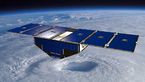
    Surrey Satellite Technology’s Space GNSS Receiver Remote Sensing Instrument (SGR-ReSI) is the primary payload onboard NASA’s CYGNSS constellation, launched today, Dec. 15, from Cape Canaveral Air Force Station in Florida.

    The Cyclone Global Navigation Satellite System (CYGNSS) mission is part of the NASA Earth System Science Pathfinder Program that aims to improve extreme weather prediction by studying how tropical cyclones form.

    Artist's concept of one of the eight CYGNSS satellites in orbit. (Image: NASA/University of Michigan)
    Artist’s concept of one of the eight CYGNSS satellites in orbit. (Image: NASA/University of Michigan)

    The CYGNSS space segment consists of a constellation of eight micro satellites, each carrying the Surrey SGR-ReSI as the observatory payload in the form of a delay Doppler mapping instrument (DDMI). Making use of reflected global positioning signals, the DDMI collects ocean surface roughness data using a technique called GNSS reflectometry, providing CYGNSS with a new method for looking inside hurricanes. Wind speed will be estimated from this reflectometry data.

    “At the end of last year, we delivered the SGR-ReSI flight models, low-noise amplifiers, and antennas to Southwest Research Institute for final integration into the CYGNSS observatories — marking a significant hardware shipment out of our Englewood, Colorado, manufacturing facility,” said Clare Martin, vice president of programs at Surrey Satellite Technology U.S.. “All of us at Surrey are proud that our instrument is playing an integral role in this mission, and we will watch with great interest as the satellites are put to work.”

    The CYGNSS team is made up of the University of Michigan Department of Climate and Space Sciences and Engineering, Southwest Research Institute (SwRI), Surrey Satellite Technology and Sierra Nevada Corporation.

    Surrey Satellite Technology demonstrated the concept of GNSS reflectometry for the first time on its UK-DMC mission launched in 2003, and subsequently developed the SGR-ReSI, which is currently flying on Surrey’s TechDemoSat-1 mission.

    CYGNSS is NASA’s first Earth science small satellite constellation, designed to help improve forecasting hurricane intensity, hurricane tracks and storm surges.

    CYGNSS will measure previously unknown details crucial to accurately understanding the formation and intensity of tropical cyclones and hurricanes.

    “This is a first-of-its-kind mission,” said Thomas Zurbuchen, associate administrator for NASA’s Science Mission Directorate at the agency’s headquarters in Washington. “As a constellation of eight spacecraft, CYGNSS will do what a single craft can’t in terms of measuring surface wind speeds inside hurricanes and tropical cyclones at high time-resolution, to improve our ability to understand and predict how these deadly storms develop.”

    The CYGNSS mission is expected to lead to more accurate weather forecasts of wind speeds and storm surges — the walls of water that do the most damage when hurricanes make landfall.

    Using the same GPS technology that allows drivers to navigate streets, CYGNSS will use a constellation of eight micro satellite observatories to measure the surface roughness of the world’s oceans. Mission scientists will use the data collected to calculate surface wind speeds, providing a better picture of a storm’s strength and intensity.

    Unlike existing operational weather satellites, CYGNSS can penetrate the heavy rain of a hurricane’s eyewall to gather data about a storm’s intense inner core. The eyewall is the thick ring of thunderstorm clouds and rain that surrounds the calm eye of a hurricane. The inner core region acts like the engine of the storm by extracting energy from the warm surface water via evaporation into the atmosphere.

    The latent heat contained in the water vapor is then released into the atmosphere by condensation and precipitation. The intense rain in eyewalls blocks the view of the inner core by conventional satellites, however, preventing scientists from gathering much information about this key region of a developing hurricane.

    “Today, we can’t see what’s happening under the rain,” said Chris Ruf, professor in the University of Michigan’s Department of Climate and Space Sciences and Engineering and principal investigator for the CYGNSS mission. “We can measure the wind outside of the storm cell with present systems. But there’s a gap in our knowledge of cyclone processes in the critical eyewall region of the storm — a gap that will be filled by the CYGNSS data. The models try to predict what is happening under the rain, but they are much less accurate without continuous experimental validation.”

    The CYGNSS small satellite observatories will continuously monitor surface winds over the oceans across Earth’s tropical hurricane-belt latitudes. Each satellite is capable of capturing four wind measurements per second, adding as many as 32 wind measurements per second for the entire constellation.

    CYGNSS is the first complete orbital mission competitively selected by NASA’s Earth Venture program. Earth Venture focuses on low-cost, rapidly developed, science-driven missions to enhance our understanding of the current state of Earth and its complex, dynamic system and enable continual improvement in the prediction of future changes.

  • 2016 fleet management technology report now available

    2016 fleet management technology report now available

    A new report that explores technologies for U.S. commercial fleets is now available.

    The 2016 Fleet Management Technology Report, sponsored by GPS Insight, includes results of a survey conducted by Bobit Business Media, publisher of Automotive Fleet Magazine, Fleet Financials Magazine, Business Fleet Magazine, and Work Truck Magazine.

    Cover: 2016 Fleet Management Technology ReportGPS Insights asked a series of questions pertaining to fleet management and telematics to examine the current state and experiences of the marketplace.

    Commercial fleets across the U.S. are finding that telematics is providing insight they never had before which helps to reduce costs, reduce risk, and increase revenue. Most industry reports state that the adoption rate is somewhere between 30-40 percent. The findings in this report are similar, and includes additional data broken down by region, fleet size, and industry.

    “We put this report together for business owners and fleet managers to get a clear understanding of what their peers are saying about their experience with telematics,” said Ryan Driscoll, marketing director of GPS Insight. “We also want it to serve as a guide for those looking to implement a better telematics solution or for those looking for the first time.”

    Topics covered in the report include:

    • Adoption: Who is and isn’t using telematics
    • Choosing a provider: What fleets say is important to consider
    • Benefits: How it’s helping commercial businesses
    • Return on investment: What fleets should expect from the investment

    The report can be downloaded from the GPS Insight website.

  • Septentrio reference receivers to monitor volcanoes for USGS

    Pictured are the Three Sisters volcanoes in Central Oregon. Photo: USGS / Lyn Topinka
    Pictured are the Three Sisters volcanoes in Central Oregon.
    Photo: USGS / Lyn Topinka

    Septentrio has completed delivery of PolaRx5 multi-constellation GNSS reference receivers and antenna systems to the U.S. Geological Survey (USGS).

    The monitoring systems will be deployed through the Volcano Hazards Program (VHP) for volcano monitoring stations in Alaska and at various international locations through the Volcano Disaster Assistance Program (VDAP) — a cooperative effort between the USGS and the U.S. Agency for International Development’s Office of U.S. Foreign Disaster Assistance.

    The PolaRx5 receivers take full advantage of the new 5.1.0 firmware which includes support for onboard PPP and dynamic response tuned for seismic applications. The PolaRx5 tracks all visible signals from Galileo, GPS, GLONASS, BeiDou, IRNSS and QZSS constellations. It provides measurement quality and robust interference mitigation through Septentrio’s patented AIM+ technology. The PolaRx5 supports these advanced features and more with a power consumption that is scalable from less than 2.0 watts.

    “USGS and their partners will be among the first to exploit the PolaRx5’s seismic monitoring features,” said Neil Vancans, vice president of Septentrio Americas. “The PolaRx5 is Septentrio’s most complete GNSS receiver to date and provides the ideal upgrade for modernizing any continuously-operating reference station (CORS) network.”