Category: Applications

  • NDGPS to remain operational, fewer sites face decommissioning

    NDGPS to remain operational, fewer sites face decommissioning

    The United States Coast Guard, Department of Transportation and Army Corps of Engineers have issued a notice that reduces the number of Nationwide Differential Global Positioning System (NDGPS) sites that will be decommissioned.

    The agencies published a notice on Aug. 18, 2015, seeking public comments on the proposed shutdown and decommissioning of 62 the then-existing 84 NDGPS sites.

    “After a review of the comments received, we have reduced to 37 the number of NDGPS sites to be shut down, nine of which are USCG Maritime sites and 28 of which are DOT inland sites,” the notice reads. “As a result of this action, the NDGPS system will remain operational with a total of 46 USCG and USACE sites available to users in the maritime and coastal regions.”

    Over time, a number of factors have contributed to the declining public use of the NDGPS, including lack of a carriage requirement, technological advances in GPS and limited availability of consumer-grade DGPS receivers.

    The Federal Register Notice reduces the number of Differential GPS sites throughout the country, while maintaining coverage in major maritime ports and waterways.

    Read the full notice at the Federal Register website, including a list of sites to be decommissioned. Termination of the broadcast signal is scheduled to occur within the next 30 days.

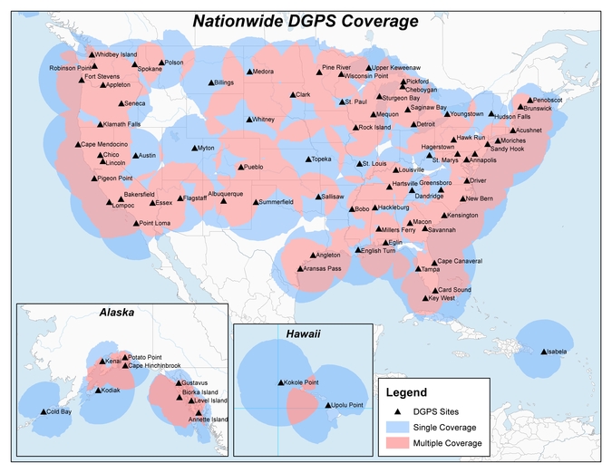
    Graphic depicting NDGPS after site reductions. (U.S. Coast Guard)
    Graphic depicting NDGPS after site reductions. (U.S. Coast Guard)
    Graphic depicting NDGPS coverage after site reductions. (U.S. Coast Guard)
    Graphic depicting NDGPS coverage after site reductions. (U.S. Coast Guard)
    Original NDGPS coverage.
    Original NDGPS coverage.
  • Kids’ smartwatch developed with u-blox

    Kids’ smartwatch developed with u-blox

    KIWI PLUS, a Korean software-development company, has launched a new children’s smartwatch developed in collaboration with u-blox.

    LINE Kids Watch is a tiny and colorful wearable with LINE emojis functioning as an Android-based smartwatch and officially distributed by KT Corporation. It enables precise tracking of the whereabouts of children, while also offering educational and interactive content.

    KIWI-PLUS-WLINE Kids Watch uses KIWI PLUS’ own Internet of Things (IoT) platform for wearables, KIWI Edge. Designed with a simple LCD screen for one-touch calling, it also provides real-time accurate location tracking and convenient safety zone setting. An emergency notification can easily be initiated by the child and text messages are sent by speaking into a microphone. Other features include an education quiz and a Cashbee NFC money pocket function.

    “We wanted to offer accurate tracking combined with high quality cellular communication, and u-blox has already demonstrated with leading brands of children’s watches its unique combination of GNSS positioning and wireless communication technologies. And considering the small size, low power consumption and powerful location accuracy of its products as well as the speed with which they helped us solved issues, u‑blox was the right choice,” explained Sangwon Seo, CEO of KIWI PLUS.

    The u-blox cellular module SARA-U270 and u-blox 7 GNSS chip UBX-G7020-KT are embedded in the smartwatch. The SARA-U270 UMTS/HSPA module provides efficient and cost-effective high-speed mobile connectivity in an ultra-small LGA form factor.

    The high performance UBX-G7020 multi-GNSS chip supports GPS, GLONASS, QZSS and SBAS and delivers exceptional sensitivity and acquisition times. It has ultra low-power consumption and a very small solution footprint of 30 square millimeters.

    “It was very exciting to collaborate with KIWI PLUS, as we at u-blox are committed to support our customers by combining technologies for reliable solutions,” explains Shone Kim, Country Manager of u-blox Korea. “We foresee further collaboration with KIWI PLUS in the future, using our LTE technology.”

    Wearables are small portable devices that support our daily life, and deliver on-the-spot services thanks to their wireless connectivity and positioning capability. Low power technologies offer a long battery life, and with outstanding radio capabilities, a robust user experience. The market for this type of high technology integration is growing strongly, so price levels are quickly becoming competitive.

  • Leica expands lidar capabilities in ALS80 airborne sensor

    Leica expands lidar capabilities in ALS80 airborne sensor

    Leica Geosystems ALS80.
    Leica Geosystems ALS80.

    Leica Geosystems, global leader of measurement and reality capture technologies, today announced it has expanded functionality of the popular ALS80 airborne sensor that enables even more flexible data acquisition with extended range measurement capability.

    The new ALS80-UP takes advantage of the proven dual-output optical system pioneered in the Leica Geosystems ALS70 and enhanced in the ALS80. The system also benefits from higher Multiple Pulse in Air (MPiA) operation settings, enabling data collection in extreme terrains with minimal variation in swath width due to terrain elevation variations.

    Forest assessment using the ALS80.
    Forest assessment using the ALS80.

    The ALS80-UP works in a wide variety of scenarios, including wide-area mapping, detail mapping from high flying heights and detail mapping over mountainous terrain. With its expanded maximum range, the system has demonstrated great results at up to 6,000 meters above terrain and with terrain relief of up to 2,300 meters.

    Leidos, Inc., a science and technology solutions leader in national security, health and infrastructure, worked with the ALS80-UP during testing trials. Using the enhanced lidar capabilities to improve flight crew safety when mapping in remote regions, the organization found the increased flying heights beneficial to its mission of defending digital and physical infrastructure.

    “We have really put the ALS80-UP through its paces, particularly at high flying heights that are important to our clients. The system has exceeded our expectations with everything we have thrown at it, including some at double the flying height of our current missions,” said Derwin Cantrell, Leidos Geospatial Programs Division program manager. “The sensitivity and point density at altitude significantly increase mission productivity, and do so without giving up flexible performance at low flying heights.”

    “We are proud to continue our commitment to extending capabilities and efficiency of the ALS product line, to help make the important work like what Leidos provides even more productive,” said John Welter, Leica Geosystems Geospatial Solutions Division president. “As our customers continue to innovate with our superior airborne sensor technology,, we are dedicated to advancing the industry and professional with new technology founded in our leading research and development.”

  • Esri agreement to provide access to Chinese maps, imagery

    Dean Angelides, director of International Operations, Esri (left), and Feng Xianquang, director for NGCC, signed the historic agreement to share data with users around the world.
    Dean Angelides, director of International Operations, Esri (left), and Feng Xianquang, director for NGCC, signed the historic agreement to share data with users around the world.

    Esri and the National Geomatics Center of China (NGCC) have signed an agreement providing access to NGCC’s mapping web services, starting this fall.

    The historic agreement will allow more users outside of China to access the country’s authoritative cartographic and imagery data. Users of the Esri ArcGIS platform will have access to the maps for no additional charge.

    NGCC is a government agency attached to National Administration of Surveying, Mapping (NASG) and Geoinformation of China. NGCC is responsible for national data that is used in surveying and mapping projects in China, as well as facilitating the scientific and technological communication between agencies in China, in the areas of sharing geographic data and services over the web.

    “The cooperation between NGCC and Esri will enable a large number of ArcGIS online users to gain access to the rich regional online geodata of China,” said Zhigang Li, NASG chief engineer, on behalf of NASG. “The agreement will facilitate the scientific and technological communication between agencies by sharing geographic information and services over the web in the Asia Pacific Region. NGCC hopes this joint work is able to promote regional, even global, promotion of spatial data.”

    “We are honored to work with the government of China to provide access to the most current and authoritative basemaps for the country,” said Jack Dangermond, president of Esri. “We look forward to continued collaboration.”

    The web services will be available in the third quarter of 2016.

    Photo: Esri

  • TomTom, sensewhere team on indoor location-based services

    TomTom, sensewhere team on indoor location-based services

    TomTom has entered a technology collaboration with sensewhere, a provider of indoor positioning technology. According to the companies, the collaboration will enable the two companies to conquer GPS black spots and bring location-based services indoors.

    TomTom Indoor delivers accurate customized indoor maps of public and private venues for site operators and other partners that enable increased efficiency, cost savings and an improved customer experience.

    sensewhere has developed a proprietary and patented positioning solution for mobile devices. The combination of TomTom’s maps — both indoor and traditional navigation maps — and sensewhere’s accurate indoor positioning will enable a seamless navigation experience indoors and outdoors.

    sensewhere enables location for indoor locations such as shopping malls.
    sensewhere algorithms enable location for indoor locations such as shopping malls, using sensors such as Wi-Fi and Bluetooth.

    “Access to indoor positioning technology, coupled with highly accurate indoor maps, means that guidance can be integrated into the day-to-day operations of a wide variety of venues, including enterprise facilities, shopping malls, airports, hospitals and more,” said Pieter Gillegot-Vergauwen, vice president, Maps Product Management, TomTom. “With the explosion of the Internet of Things, we believe that by partnering with sensewhere our customers will not only be able to gain efficiencies, but will also deliver a better experience to their own customers.”

    “We are excited to help TomTom extend its navigation prowess indoors with this technology collaboration,” said Rob Palfreyman, CEO of sensewhere. “We believe this integration is a perfect fit for enterprises that need to combine location intelligence, resource planning and efficient execution.”

    sensewhere-mall-O
    Where’s Waldo? sensewhere uses pinpoint people to illustrate how its system works in a home page video.
  • Geospatial World Forum looks at Galileo, EGNOS for GIS

    Tim Reynolds
    Tim Reynolds

    By Tim Reynolds
    Contributing Editor for Europe

    The eighth edition of the Geospatial World Forum took place May 23–26 in Rotterdam, The Netherlands, attracting professionals from the surveying and geospatial information system (GIS) sectors. I attended the event on May 24 and took part in a workshop that looked at the benefits of Galileo and EGNOS in geospatial applications in the context of the imminent launch of Galileo initial services.

    An industry survey undertaken by the GSA indicates that already more than 80 percent of GNSS receivers for surveying and mapping use are EGNOS-enabled, while 77 percent of geospatial reference network providers have enough information to upgrade Galileo and will be ready to provide a service by 2017. All good news. On the less positive side, more than 60% of professional surveyors did not know about EGNOS!

    The workshop also talked up the potential for synergies between Galileo GNSS and Copernicus Earth Observation (EO) systems — a topic of immense interest at the European Space Solutions as well. Hans Dufourmont from the European Environment Agency (EEA) highlighted the use of GNSS to track animal species and monitor migration paths when considering development opportunities. He saw a huge potential for synergies between geopositioning and surface imaging going forward.

    Maurice Barbieri, president of the Council of European Geodetic Surveyors (CLGE), also saw a “clear role for Galileo” in the surveying community with its potential ability to meet centimeter accuracy requirements much more than for EGNOS.

    He also speculated about the value of establishing a European Geoinformatic Agency that might coordinate the provision of European GNSS and EO data. He felt the private business community would appreciate such simplification.

  • Spectra Precision MobileMapper 50 combines smartphone design with GNSS capabilities

    Spectra Precision MobileMapper 50 combines smartphone design with GNSS capabilities

    Spectra Precision has announced its new MobileMapper 50 GNSS handheld device for simple GIS data collection or for use as a data controller for Spectra Precision SP60 and SP80 GNSS receivers. Available with an Android OS, the MobileMapper 50 combines smartphone capabilities with a ruggedized design to improve positioning accuracy.

    The company made the announcement at the 2016 Esri User Conference, being held in San Diego, California, June 27-July 1.

    Together with the MobileMapper 50, Spectra Precision also introduced two new software applications: an Android OS version of MobileMapper Field software for GIS professionals and Spectra Precision Survey Mobile software to control SP60 and SP80 GNSS receivers.

    “In today’s market, GIS and survey professional users are looking for a smartphone device experience, but still require a professional, rugged and waterproof design,” said Olivier Casabianca, general manager of Trimble’s Spectra Precision Division. ”With the MobileMapper 50 we can address all these requirements and more — real-time accuracy, the latest connectivity capabilities and a rugged compact design.”

    The MobileMapper 50 is available in two versions: both with Android OS and Wi-Fi, and with optional 4G LTE cellular module. The rugged, smartphone-like device is IP67 rated, thin (14.6 mm) and lightweight (300 grams or 10.6 ounces).

    It also features a 1.2 GHz quad core processor, 5.3 inch sunlight readable display, large memory (8 or 16 GB, depending on the version) and a high-resolution, built-in camera (8 or 15 MP, depending on the version). As a professional device, the MobileMapper 50 provides accurate GNSS positioning, supporting SABS, GPS, GLONASS and BeiDou constellations as well as post processing for improved accuracy.

  • How worried are you hackers will discover our locations?

    For consumer navigation and location-based services, how worried should we be about hackers discovering or corrupting our locations?

    Three industry experts gave their opinions on this issue — now it’s your turn!

    Go to env-gpsworld-integration.kinsta.cloud/july poll and register your vote. Do so by July 20 and you’ll be entered into a drawing for a $50 Visa gift card.

    For the record, here’s how the experts weighed in.

    Janice Partyka
    Headshot: Janice Partyka

    Janice Partyka, Contributing editor, GPS World; Principal, JGP Services

    A: Very worried. Just about any connected device can be hacked, including iPhones or Android phones, regardless of fingerprint recognition technology or complex passwords. Hackers can listen to conversations or access the location positioning via flaws in a portion of mobile networks called Signaling System 7. Hackers using common software-defined radio tools have discovered a cheap way to make a GPS emulator to falsify the GPS location of smartphones and in-car navigation systems.

    Paul McBurney
    Headshot: Paul McBurney

    Paul McBurney, Founder, CEO, Gopherhush Corp.

    A: Mobile phone users will share location-based information of business travel mileage, driving
    behavior for usage-based car insurance, toll-road usage, or even time cards. The best way for the receiving party to protect against location hacking or even errant fix data is to require cross-checking of the location data with multiple location sources based on GNSS, OS network location, Wi-Fi and Bluetooth reference points, and even the phones sensors. It’s RAIM against hacking.

    Todd Humphreys
    Headshot: Todd Humphreys

    Todd Humphreys, Professor, Director, Radionavigation Lab, University of Texas

    A: We usually don’t mind some people knowing our position some of the time, but it’s uncomfortable to think that a hacker or a government could accurately track our position whenever they want. Your credit card number is a lot more valuable to the average hacker than your location, so the danger of location theft is low, unless you’re the special target of someone’s profiling or blackmail scheme. As for a hacker corrupting a location, this is a serious problem that needs addressing if connected cars are ever to trust one another’s data.

  • Trimble unveils TDC100 handheld data collector at Esri UC

    Trimble unveils TDC100 handheld data collector at Esri UC

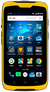
    TDC100 Series Handheld Photo: Trimble
    TDC100 Series Handheld
    Photo: Trimble

    Trimble introduced its Trimble TDC100 handheld data collector at the 2016 Esri User Conference, which is being held July 27 to July 1 in San Diego, California.

    An entry-level GNSS device for a variety of geographic information system (GIS) applications, the Trimble TDC100 combines both smartphone and ruggedized data collection capabilities in a single, mobile device, the company says in a news release.

    The Android-based TDC100 can run commercially available or in-house developed applications on a professional, IP-67 ruggedized platform with a sunlight readable display and user replaceable batteries. The built-in GNSS receiver also provides real-time accuracy.

    The Trimble TDC100 is available in two models — both models are available with an Android operating system and Wi-Fi, with an optional 4G LTE cellular version. It has a high-resolution 5.3-inch display, an 8 MP (Wi-Fi model) or 13 MP (4G LTE model) camera, and lithium-ion batteries in standard or enhanced capacity. It also supports GPS, GLONASS and BeiDou, as well as satellite-based augmentation system (SBAS) capabilities.

    “GIS professionals using GNSS handheld devices for a wide range of data collection applications are expressing a desire for smartphone like capabilities in a built-to-last form factor,” says Ron Bisio, vice president of Trimble’s geospatial division. “We believe the TDC100 will be a workhorse. It has been designed for mobile workers who need a functional field computer that is tougher than a consumer-grade device, while providing easy-to-use features and convenience that people have come to expect. Users can collect and retrieve highly accurate spatial data anytime, and from virtually any place, while remaining in touch with the office — with a single device.”

    Trimble TDC100 is expected to be available through Trimble’s geospatial distribution channel in mid-August 2016.

  • ArcGIS apps for the field launched at Esri UC

    ArcGIS apps for the field launched at Esri UC

    Esri has launched two new ArcGIS apps for field operating efficiency at the Esri User Conference, being held June 27–July 1 in San Diego. Attendees can see live demonstrations and experiment with Drone2Map for ArcGIS and Survey123 for ArcGIS.

    “These two apps are already becoming game changers,” said Esri President Jack Dangermond. “What we’ve done is make it much easier for our users to collect data, including imagery, and then right away start working with that data — mapping, analyzing, sharing—in ArcGIS.”

    Drone2Map for ArcGIS provides safe and affordable imagery on demand—a benefit especially useful to people who work in land analysis or infrastructure inspection and those monitoring events such as natural disasters and environmental change. Drone2Map takes still imagery captured by a drone and quickly turns it into high-quality 2D and 3D products in ArcGIS.

    The app detects camera and sensor parameters and intelligently applies appropriate defaults. Its rapid-process capability allows teams in the field to be sure they’ve captured everything they need to avoid costly return trips. The imagery products created using Drone2Map can be used for analysis in ArcGIS Online and ArcGIS Pro to support informed decision-making.

    Esri Survey123.
    Esri Survey123.

    Survey123 for ArcGIS is a simple yet powerful form-centric field data gathering solution that makes it possible to create, share, and analyze surveys in three easy steps. With Survey123, paper forms are effectively transformed into digital surveys. Surveys, from simple to sophisticated, are authored and then shared in ArcGIS.

    Using the Survey123 mobile app for iOS, Android or Windows, teams in the field capture survey results with their smartphones and tablets, even in disconnected environments. Data captured in the field is immediately available for analysis in ArcGIS to help users make better decisions. Survey123 is a versatile data collection solution already popular with people in public health, education, public works, disaster response, and humanitarian agencies.

    Attendees of the Esri User Conference can see live demos and get hands-on experience with both of these new apps along with hundreds of other solutions designed to enable a smarter world.

    ]The annual event attracts 16,000 geographic information system (GIS) users, managers, and developers. It offers 300 moderated sessions, 450 hours of technical training, access to 300 software vendors, inspirational keynotes, and one-on-one sessions with Esri technical and professional support staff. See more of GPS World’s coverage.

    Learn more about Esri apps for the field.

  • 3DR to integrate Site Scan with Esri Drone2Map

    Today at the Esri User Conference, 3DR announced that it has teamed up with Esri to integrate 3DR’s Site Scan with Esri Drone2Map.

    Designed for the field professional, Site Scan is an intuitive, powerful and open aerial data capture and analytics platform that delivers an end-to-end solution ready-made for existing mapping and survey workflows, 3DR said in a news release. With Site Scan and Drone2Map, Esri customers can safely, quickly and easily conduct surveys with the Solo smart drone and effortlessly deliver that data to ArcGIS and ArcGIS Online.

    “Aerial data capture technology is bringing about a revolution in surveying and mapping,” said Lawrie Jordan, Director of Imaging and Remote Sensing at Esri. “We are thrilled to partner with 3DR to streamline the creation of professional imagery products with Site Scan and Drone2Map for ArcGIS. Together we will accelerate the development and use of remote sensing across all industries.”

    Site Scan automatically calculates a flight plan and Solo autonomously executes both flight and image capture. Images are processed and integrated with Esri Drone2Map to create high-resolution georeferenced maps and digital elevation models to share as tile or feature services in ArcGIS and ArcGIS Online.

    “Capturing site data today is costly, time consuming and often dangerous. Drones can easily go where it’s inefficient or unsafe for field personnel, making it easier to accurately measure our world so we can better analyze and manage it,” said Chris Anderson, CEO of 3DR. “We’re delighted to partner with such a great industry leader and integrate Site Scan with Esri Drone2Map. Together, we offer a complete solution for site capture that will help our customers create maps that tell stories, record change over time and perform analysis all while saving time, saving money and keeping humans out of harm’s way.”

    Site Scan makes it safer and easier than ever for people in land management, GIS, mapping, energy, infrastructure and related fields to aggregate and process multiple forms of aerial imagery and data and easily incorporate them into the Esri tools they use every day, 3DR said.

    Engineering and survey firm McKim & Creed, based in Fort Worth, Texas, is one customer. “Utilizing the 3DR Solo and SiteScan allowed McKim & Creed to confidently collect accurate spatial information in dangerous and demanding environments where it would have been difficult to use traditional survey methods,” said Christian Stallings, R&D Manager at McKim & Creed.

    “Using Esri’s Drone2Map software, surveyed ground control and 3DR’s Solo, we were able to collect detailed elevation information and high-resolution orthophotography over a dredging containment pond operated by the United States Army Corps of Engineers (USACE). This approach proved to be accurate and kept people out of harm’s way — which would only be achievable using this approach,” Stallings said.

    3DR designed Site Scan as an open and extensible platform. On the hardware side, the Solo smart drone has open gimbal and accessory bays, which give both 3DR and their global technology partners the ability to integrate additional cameras and sensors.

    Additionally, Solo firmware updates optimize the drone’s flight profile and performance. On the software side, 3DR continually updates the Site Scan application so that customers can take advantage of the most recent and advanced analytics technologies.

    With Site Scan, even users new to drone technology will fly with confidence from day one. The Site Scan app includes 3DR’s airspace safety information software, which alerts users if they’re about to fly in restricted airspace. They can then pull up a map of the area with all restrictions around them clearly marked.

    To support enterprise customers further, 3DR offers Success Services, including the Premier Success Plan. Included with their purchase of Success Services, all Site Scan users will have access to experts on Site Scan and Solo. They will also have a Solo overnight replacement guarantee should anything go wrong with one of their drones.

    Site Scan with Solo Enterprise is available immediately for order on store.3dr.com, priced at $3249 with a monthly service fee of $499 paid annually with a 12-month commitment.

  • GPS World reports live from the 2016 Esri User Conference

    GPS World reports live from the 2016 Esri User Conference

    The 2016 Esri User Conference, the mecca of geographic information systems (GIS) in the U.S., takes place June 28 to July 1 in San Diego, California. The conference is designed to give attendees practical advice and hands-on experience with GIS tools from Esri and other companies, as well as share ideas and best practices for improving our world through maps.

    The event encompasses 16,000 GIS users, managers and developers; 300 moderated sessions; 450 hours of technical training; and 300 software vendors.

    GPS World/Geospatial Solutions staff is on site, and we will be posting news, photos and videos live from the show on this page. Also follow us on Twitter at @GSS_NCM and @GPSWorld.

    NEWS

    Spectra Precision MobileMapper 50 combines smartphone design with GNSS capabilities


    Golden Software releases Strater 5 well log, borehole and cross-section plotting program (6/28)

    Trimble unveils TDC100 handheld data collector at Esri UC

    SAP debuts Geographical Enablement Framework at Esri UC (6/28)

    ArcGIS apps for the field launched at Esri UC (6/27)

    3DR to integrate Site Scan with Esri Drone2Map (6/27)

    Esri, DigitalGlobe partner to expand World Imagery Map (6/27)

    CoreLogic expands location-based intelligence with building footprints (6/27)

    Laser Technology shares new time-saving mapping tools at Esri UC (6/23)

    Septentrio to spotlight drone GNSS solutions at Esri UC (6/23)

    PHOTOS

    VIDEO PLAYLIST