Sierra Wireless has released an advanced fleet management feature to support the company’s AirLink GX450 mobile gateway, allowing it to collect OBD-II vehicle telemetry data.
The added functionality will enable large organizations and fleet management solution providers to rapidly develop applications to monitor vehicle health and performance, helping them reduce costs, streamline operations and increase efficiency.
Managing a vehicle-based workforce involves a large group of stakeholders, including operations, IT and fleet management. By combining mobile networking and rich vehicle telematics onto a single platform that gathers and reports vehicle diagnostic data directly to applications, this new feature will simplify and centralize vehicle management across an organization. Organizations will no longer need to purchase a separate in-vehicle telematics platform to gather and monitor vehicle health data.
“We added advanced, easy-to-use telemetry to the AirLink GX450 to enable customers to simplify the adoption of vehicle telemetry solutions, including the ability to leverage their existing investment in fleet communications equipment,” said Jason Krause, senior vice president, Enterprise Solutions, Sierra Wireless.
Clevest, a provider of mobile workforce management solutions for utilities, has worked closely with Sierra Wireless through the development of the AirLink GX450’s vehicle telemetry feature to produce a complete workforce management and vehicle monitoring solution.
“Our mobile workforce platform is tightly integrated with AirLink gateways,” said Edna Menon, senior product marketing manager, Clevest. “With the GX450 telemetry feature, our utility customers can take advantage of robust vehicle diagnostic capabilities, in addition to the reliability and ease-of-use of our integrated solutions.”
The AirLink GX450 vehicle telemetry uses an optional OBD-II accessory to collect vehicle diagnostic data and send it to a remote server using an open messaging protocol (MQTT). Vehicle telemetry is designed for applications in public safety, utilities, emergency and field services, and for large organizations or fleet management solution providers that have the in-house resources to develop their own vehicle monitoring applications.
A new recommended practice has been issued for GIS and mapping professionals responding to an oil spill.
The document — the final report of a joint project — guides professionals in using GIS technology and geospatial information to form a “common operating picture” for a spill response, so various organizations can deal with it effectively.
According to the report, the 2010 Deepwater Horizon spill in the Gulf of Mexico showed the need for a coordinated response based on timely geographic data.
The International Association of Oil & Gas Producers (IOGP) through the Geomatics Committee and IPIECA (the global oil and gas industry association for environmental and social issues) issued the recommended practice in cooperation with the Open Geospatial Consortium (OGC) and Resource Data.
Officially named the OGC IOGP/IPIECA Recommended Practice for a Common Operating Picture for Oil Spill Response, the document is the final report of the IOGP/IPIECA Joint Industry Project to produce a recommended practice for GIS/mapping in support of oil spill response and for the use of GIS technology and geospatial information in forming a Common Operating Picture (COP) for management of the response.
“The report lays the groundwork for coordinated activities by multiple stakeholders that need to come together quickly to respond to a spill,” said Rob Cox, Technical Director, IPIECA. “Having the report endorsed as an OGC Best Practice gives it the authority it needs to act as a focal point in support of that coordination.”
As stated in the report:
“Responding to an oil spill requires access to and understanding of many types of information. Effective, coordinated operations for the response are based on a shared, common picture of the situation. Interoperability provides shared situational awareness of the crisis and the response activities. What is needed is a common picture of reality for different organizations that have different views of the spill so that they all can deal with it collectively.
“Recent oil spills have provided lessons learned and recommendations on forming a Common Operating Picture for oil spill response. Through a joint project, industry is responding to the call, moving from recommendations to reusable best practices supported by open standards that can be deployed quickly in any region of the globe.
“This architecture report is part of the IOGP and IPIECA Oil Spill Response – Joint Industry Project (IOGP–IPIECA OSR-JIP) to produce a recommended practice for GIS/mapping in support of oil spill response and for the use of GIS technology and geospatial information in forming a Common Operating Picture to support management of the response.”
About the players
The Open Geospatial Consortium (OGC) is an international consortium of more than 515 companies, government agencies, research organizations, and universities participating in a consensus process to develop publicly available geospatial standards. OGC standards support interoperable solutions that “geo-enable” the Web, wireless and location-based services, and mainstream IT. OGC standards empower technology developers to make geospatial information and services accessible and useful with any application that needs to be geospatially enabled.
The International Association of Oil & Gas producers (IOGP) is a unique global forum in which members identify and share best practices to achieve improvements in every aspect of health, safety, the environment, security, social responsibility, engineering and operations. IOGP encompasses most of the world’s leading publicly-traded, private and state-owned oil & gas companies, industry associations and major upstream service companies. IOGP members produce more than half the world’s oil and about one third of its gas.
IPIECA is the global oil and gas industry association for environmental and social issues. IPIECA was formed in 1974 following the launch of the United Nations Environment Programme (UNEP). IPIECA is the only global association involving both the upstream and downstream oil and gas industry on environmental and social issues. IPIECA’s membership covers over half of the world’s oil production. IPIECA is the industry’s principal channel of communication with the United Nations. When IPIECA was set up in 1974 the acronym stood for the International Petroleum Industry Environmental Conservation Association. In 2009, recognizing that this no longer accurately reflected the breadth and scope of the association’s work, IPIECA stopped using the full title. The association is now known as IPIECA, the global oil and gas industry association for environmental and social issues.
Resource Data, Inc. (RDI) has been supporting the oil & gas industry with information technology for spill response since 1989. RDI brings unparalleled experience to oil spill response, leading the geographic information system (GIS) and database teams for the Exxon-Valdez spill and more recently the GIS response team in the Macondo/Deepwater Horizon spill. RDI has developed numerous spill response data systems, participated in multiple drills, and developed risk analysis systems for major pipeline networks. Our depth and breadth of expertise in spill preparedness and response uniquely positions RDI to assist in the development of a Common Operating Picture for the oil and gas industry.
Woolpert has signed a five-year, multimillion-dollar Geospatial Product and Services Contract 3 (GPSC 3) with the U.S. Geological Survey (USGS) to provide mapping and surveying services.
The GPSC is a suite of contracts used by federal, state and municipal government entities to partner with USGS for the purpose of fulfilling their geospatial data requirements.
The contract will be administered through the National Geospatial Technical Operations Center (NGTOC) in an effort to obtain geospatial data services throughout the United States and its territories. The contract also will be used to support the 3D Elevation Program (3DEP) and used by other federal, state and local agencies.
“This provides Woolpert with the opportunity to continue working with USGS on their 3D Elevation Program (3DEP), an eight-year program to provide highly accurate 3D elevation data of the entire U.S.,” said John Gerhard, Woolpert project director. “This data will be collected via lidar (light detection and ranging) to create the most accurate surface model, and will be used to evaluate flood risk and natural resources, support FEMA, help farmers with precision agriculture, assess and manage infrastructure, and much more.”
Jeff Lovin, Woolpert senior vice president and director of government solutions, said the Woolpert staff is proud to have had the opportunity to work with the USGS for nearly 25 years. “Over those 25 years, we’ve had the opportunity to collaborate on different layers of the National Spatial Data Infrastructure (NSDI), from the development of nationwide imagery in the 1990s to 3D elevation and hydrography today,” Lovin said.”It’s very gratifying to have the opportunity to play a part in such an important program for our nation.”
The American Association for Geodetic Surveying (AAGS) has undertaken an effort to explore creating a geodetic certification program. The geodetic certification would provide official recognition that a person has the working knowledge and skills to understand and solve practical problems in applied geodesy.
The vision is that the geodetic certification program would be similar to other existing certifications, such as the American Society for Photogrammetry and Remote Sensing (ASPRS) Certified Photogrammetrist, the GIS Certification Institute (GISCI) GIS Professional, and the National Society of Professional Surveyors (NSPS) and The Hydrographic Society of America (THSOA) Certified Hydrographer.
“As geospatial technology continues to advance and gain wider adoption, geodesy is becoming an increasingly important part of the geospatial framework,” said AAGS past president Michael Dennis, RLS, PE. “To that end, we are exploring the concept of creating a program that officially recognizes professionals with a minimum level of geodetic competence.”
To gain input from industry professionals, AAGS created an online questionnaire about the program and invites all those involved with geospatial technologies to contribute. The questionnaire is available here.
The questionnaire is intended to serve multiple purposes:
Establish an appropriate body of knowledge for applied geodesy
Determine the level of support in the geospatial community
Identify areas of interest and existing status of geodetic knowledge
Provide guidance on creating and prioritizing educational content
Show the breadth and depth of the field of geodesy
Raise awareness of the proposed program
The questionnaire also helps lay the foundation for creating a certification program and consists of 50 questions. The first ten are general questions, and the remaining 40 are divided among the eight topic areas listed below.
Geometrical Geodesy and Reference Systems
Map Projections
Physical Geodesy
Astronomic and Celestial Coordinate Systems
Global Navigation Satellite Systems
Statistics and Least Squares
Geodetic Observation Procedures and Practices
Standards, Specifications, and Guidelines
AAGS is seeking input from a broad cross section of geospatial practitioners, including surveyors, engineers, GIS professionals, photogrammetrists, programmers and any others who use geodetic methods and calculations to combine, manipulate, and analyze spatial data.
The proposed geodetic certification program is being developed in cooperation with the National Society of Professional Surveyors (NSPS). Participation of other professional geospatial organizations is currently being solicited as part of program development.
The Vale S11D mine is the largest iron ore mine in the world.
Vale’s new S11D mine is the largest iron ore project in the world. It will produce more than 90 million tons of iron ore annually when it becomes operational in the second half of 2016. Vale is leveraging technology from Septentrio and other mining companies to implement a highly automated truckless transport system that will substantially reduce fuel consumption and emissions, as well as saving water.
The Vale S11D machine control project is being managed from Septentrio Americas in Torrance, California.
Septentrio GNSS receivers and antennas will be deployed across a range of machines to provide highly accurate and reliable position and orientation. The AsteRx-U receiver family features built-in jamming detection and countermeasures, multipath rejection and fast acquisition.
With more than 500 channels to track all available constellations (GPS, GLONASS, Galileo, Beidou, IRNSS and QZSS), the receivers offer a built-in L-band receiver for PPP corrections as well as centimeter-level RTK positioning accuracy.
The AsteRx-U family also incorporates proprietary Septentrio algorithms, including LOCK+ technology to maintain tracking during heavy vibration from the machine and IONO+ technology to assure the accuracy of the position even in regions of elevated ionospheric activity. The receiver is configurable from any device with a web browser, and includes advanced capabilities such as a built-in spectrum analyzer.
“Septentrio has been a leader in multi-constellation and multi-frequency machine control GNSS receivers for the past decade,” said Neil Vancans, vice president of Septentrio Americas. “The selection of AsteRx-U receivers for Vale’s S11D project is a strong validation of Septentrio’s rugged design and high performance in challenging environmental conditions.”
Operators of UK transport networks will be the first to benefit from Live Land, a satellite-based land monitoring system developed through the European Space Agency (ESA).
Transport operators across the UK face significant challenges in monitoring and detecting landslides and subsidence across their networks. Geological hazards in the vicinity of roads and railways can disrupt business and communities.
The Live Land demonstration project will help to assess and monitor high-risk areas by providing more information on geological hazards along rail and road networks using integrated data from GNSS and Earth observation satellites.
CGG GeoConsulting‘s NPA Satellite Mapping group has been awarded a contract to lead the Live Land project, sponsored by the ESA within its Integrated Applications Program (IAP). Over the next two years, the Live Land consortium will develop a number of products for two prominent Scottish transport operators, Network Rail (Scotland) and Transport Scotland.
Once successfully demonstrated in Scotland and regions of England, Live Land is expected to expand across the UK and continental Europe as the project team engages with other transport operators who could benefit from the new information that will be available on geohazards.
The Live Land demonstration project is the follow-on of a previous ESA IAP feasibility study concluded in 2014 and draws on expertise from a team of internationally respected authorities in their respective fields:
Live Land offers transport operators increased information on geological hazards, such as landslides and subsidence. (Photo: ritish Geological Survey NERC)
How it works
Radar images from Europe’s Sentinel-1A observation satellite detect surface motion changes with millimeter precision. This is complemented with data from satnav receivers and sensors installed for in-situ monitoring in specific locations. This space-based information is combined with knowledge about the geology of the area and weather forecasts. For example, an area of steep slopes and wet soil that is expecting heavy rainfall is at a higher risk of a landslide.
Furnished with such knowledge, transport operators can assess the risks and improve their planning and response to incidents.
“Live Land integrates data collected from different sources to assess and monitor potential geological threats for transport operators,” said ESA’s Roberta Mugellesi. “Combining space-based data increases the confidence in risk assessment and predictions.”
NPA Satellite Mapping
The NPA Satellite Mappingconsultancy derives geospatial intelligence from satellite imagery. Its mapping solutions are used around the world by a client base ranging from oil and gas operators to transport asset owners to maximize operational insight and minimize risk. The company has considerable experience in geohazard research projects for ESA and European Commission, and, with its expertise in satellite InSAR (surface deformation) mapping, is optimally placed to coordinate and bring to market the unique monitoring solutions that will be developed within the Live Land project.
The services are expected to range from regional geological hazard susceptibility and activity datasets that exploit satellite InSAR measurements, to hazard forecasting models using geological and meteorological data, and the development of cost-effective, multi-sensor devices (GNSS receiver and inertial sensors) for in-situ monitoring.
“Live Land will initially play a crucial role in helping to better understand, monitor and forecast geological hazards across the UK’s road and rail networks,” said Claire Roberts, Live Land project manager and remote sensing consultant with NPA Satellite Mapping. “The developments targeted in the project are ambitious but necessary given the scale of the issues we want to address.”
Hemisphere GNSS has released the S321, its next-generation multi-frequency, multi-GNSS survey smart antenna. The S321 — designed for land or marine survey — combines Hemisphere’s Athena and Atlas technologies with a new web user interface offering customer-friendly performance.
For professional marine applications — such as marine construction, hydrographic surveying or dredging — using the S321 with Athena RTK (real-time kinematic) enables users to achieve impeccable results and maintain peak up-time, the company said. The ruggedized antenna was designed for demanding and challenging environments and meets IP67 requirements.
The S321 smart antenna by Hemisphere GNSS.
“The S321 is another example of how much Hemisphere has changed,” said Chuck Joseph, president and CEO. “A fantastic survey smart antenna with industry-leading RTK, connectivity, and management capabilities, the S321 offers unbeatable performance and value to the industry.”
Athena RTK
Athena excels in environments where high-accuracy GNSS receivers can be used. Hemisphere’s customers have tested and proven Athena’s performance in long baseline, in open-sky environments, under heavy canopy, and in locations experiencing significant scintillation.
Initialization time – Reliably consistent initialization performance, while at the same time performing initializations in less than 15 seconds at better than 99.9 percent reliability.
Robustness in difficult operating environments – Extremely high productivity under aggressive geographic and landscape-oriented environments for GNSS.
Performance on long baselines – Position stability for long baseline applications.
Performance under scintillation – Sustained accuracy under ionospheric scintillation activities.
Atlas GNSS Global Corrections
The S321 ships preconfigured to test drive corrections from Hemisphere’s Atlas global corrections service. The bundled solution provides users worldwide with an easy way to use Atlas, including the worldwide H10 service offering 8-centimeter, 95-percent accuracy (4 cm RMS).
Network RTK Augmentation
BaseLink technology allows Atlas-capable receivers like the S321 to self-calibrate, self-survey, and automatically manage the transmission of RTK correction data to augment or extend established or new GNSS reference networks in areas of poor Internet connectivity.
The S321 introduces Hemisphere’s aRTK technology. Powered by Atlas, aRTK enables the S321 to operate with RTK accuracies when RTK corrections fail. If the S321 is Atlas-subscribed, it will continue to operate at the subscribed service level until RTK is restored.
The S321 also introduces SureFix, Hemisphere’s new processor running in combination with Athena to provide high-fidelity RTK quality information that results in guaranteed precision with virtually 100 percent reliability.
Features:
Athena RTK engine
GPS, GLONASS, BeiDou, Galileo, QZSS
372 channels
Atlas corrections delivered via L-band and over the Internet
Wireless connectivity via Bluetooth and Wi-Fi
Powerful web user interface
Two versions (Each can be configured as Base or Rover):
UHF + GSM / WCDMA
GSM / WCDMA (Network Rover)
4 GB internal memory card and 64 GB-capable MicroSD card for data logging, download and upload.
The S321 can be ordered now and is available to ship before the end of the month.
The S321 is making its tradeshow debut at Oceanology International 2016 at ExCeL, London, UK, March 15-17, at booth G500.
For more information about the S321, Athena, Atlas, or its other advanced features, please call +1 (844) 217-2845 (within Canada / USA only) or +1 (480) 291-6766, or email [email protected].
Mercedes autonomous car on display at Mobile World Congress 2016. (Photo: Kevin Dennehy)
BARCELONA, Spain — Most attendees at the Mobile World Congress (MWC) wouldn’t mistake the huge mobile phone show to be a gathering of auto manufacturers and their suppliers. However, the show, which broke 100,000 participants this year, has seen a rise in auto companies who are outlining connected and autonomous vehicle strategies.
MWC was held Feb. 27 to March 2 in Barcelona.
At MWC, Ford CEO Mark Fields said the company is tripling its investment in new technologies over the next five years with the ultimate goal of fully autonomous vehicles.
Ford also rolled out the new Kuga SUV, which features the company’s new SYNC 3, which Fields says should be in 43 million vehicles by 2023 (SYNC 3 is upgraded to include improved voice commands and easier to get to applications on a driver’s smartphone).
Fields said Ford, which attended its fourth straight Mobile World Congress, was transitioning from an auto company to one that is a dual auto-mobility entity. In addition, just as with GM’s decision to invest $500 million in Lyft, Ford is getting into the sharing economy with its own car-sharing, ride-sharing and other mobility services.
This new mobility strategy includes GoPark, an app that directs drivers to parking spaces; FordPass, a platform that connects services and partners; and FordGuides, a problem-solving app. According to published reports, another Ford app is MyBoxMan, which allows drivers in Europe to make money delivering boxes.
At least one industry expert believes that car sharing and autonomy is the future for auto companies. “Full autonomy is coming. We will see fleets of driverless public transport vehicles on the roads due to their low overheads,” said Kevin Curran, senior member of IEEE and senior lecturer at the University of Ulster. “Regarding non-autonomy, we will see that cars ownership will change in a number of ways. We will start to see more ride sharing. Uber and other ride sharing models will rise to supersede existing traditional models. That is quite obvious even now, and a proper ride sharing model should also emerge, too.”
Ford displayed the Kuga in its main booth, and also had a booth featuring its Developer Program. One of its development partners, Magellan, showed off its SmartGPS in-vehicle technology.
The Magellan unit delivers local information to the car that is equipped with SmartGPS, including speed trap alerts, weather, traffic and lowest gas prices, said Matt Erstling, Magellan product manager, connected platform.
Magellan’s connected auto strategy was outlined, in part, by its new CEO, Pierre Parent, at CES in January. Parent said that the company will continue to put location capability in connected devices.
Large industry players make MWC auto announcements
At its press conference, Hans Vestberg, Ericsson president and CEO, said 5G will provide the latency needed for autonomous cars. The company is jointly developing a connected car with Geeley Automobile Holdings, the Chinese owners of Volvo. Besides Ericsson, Nokia, SK Telecom and others believe that 5G, which is expected to rollout in 2020, will be critical for mobile Internet applications — and, therefore, for better safety in connected vehicles.
Qualcomm announced its partnership with Audi to integrate the Snapdragon 602A into the automaker’s 2017 vehicles. The company showed off connected car technologies with Formula One Team Mercedes AMG Petronias.
One of the cooler pieces of equipment at MWC was the folding steering wheel developed by Harman and Rinspeed. The companies are also co-developing an autonomous car.
Harman showcased its new folding steering wheel at Mobile World Congress 2016. (Photo: Kevin Dennehy)
Besides rolling out Galaxy S7 phones, Samsung announced its Connect Auto dongle that adds LTE connectivity for older vehicles. The dongle plugs into a diagnostic port to let drivers monitor a vehicle’s performance. It also makes the vehicle a Wi-Fi hotspot. It should be available in the second quarter, with AT&T as the U.S. wireless partner.
Saying the partnership is a giant step toward driverless vehicles, Panasonic and Ficosa announced at MWC that they were developing a Smart Connectivity Module that enables passengers to be securely connected through a vehicle’s own internal connection. The system provides both inside and outside connections and works in V2V and V2X environments.
“A lot of people don’t know that 33 percent of our business is in auto and industrial systems. Consumer is only 14 percent,” said Tony O’Brien, deputy managing director, Panasonic Systems Solutions, Europe.
Inside the Mercedes autonomous vehicle. (Photo: Kevin Dennehy)
In other MWC news:
The Consumer Electronics Show (CES), which automakers and their suppliers are heading to in droves, now has 115 exhibiting companies. While far fewer in numbers, and with so many large wireless and device manufacturers involved, auto execs realize that MWC is an important stop before the Geneva Auto Show.
At MWC, I could actually talk to people, even see folks again at events and sometimes passing by in the huge exhibit halls at the Fira Grand Via. You can’t say that about CES. Unfortunately, MWC is getting huge…more than 100,000 people with the requisite traffic congestion, public transit strikes, expensive housing and airfares.
Join Lyft, BMW Group, HERE and 25 other speakers at Driverless, The Business of Autonomous Vehicles, which is March 22-23 at the Crowne Plaza Hotel, San Francisco Airport. Panels feature new technology, executive insights on the future, investments, legal and cyber security and mapping. For more information, go to www.driverlessmarket.com or [email protected].
Virtually all unmanned systems, from drones to autonomous vehicles, use GPS location technology and advanced mapping. As systems evolve, and enemy threats become more sophisticated, new requirements are emerging. The U.S. military is out in front of this trend, developing unmanned autonomous systems at an even faster pace, with more ambitious goals, than the civilian market. This is borne out by several recent tests and announcements, all profiled individually at env-gpsworld-integration.kinsta.cloud. This month’s column rounds up their essential details for a skyview of the burgeoning field.
Publisher’s note: Defense PNT columnist Don Jewell will return next month.
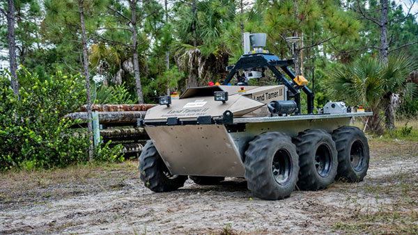
An unmanned Black Hawk delivers an autonomous ground vehicle to a remote site in a demonstration for the U.S. Army of a joint robotic air-ground mission.
Carnegie Mellon University and Sikorsky Aircraft used an autonomous helicopter and an autonomous ground vehicle to demonstrate that ground and air robots can perform complex, cooperative missions. In an October 2015 demo, an unmanned Black Hawk helicopter picked up an unmanned ground vehicle (UGV), flew a 12-mile route, delivered the UGV to a ground location and released it.
The drop-zone collaboration promises to keep warfighters out of harm’s way. For example, this type of robotic mission could avoid warfighters’ exposure to hazardous conditions, such as chemically or radiologically contaminated areas.
The Black Hawk was equipped for autonomous operation by Sikorsky, a Lockheed Martin Co. It delivered a Land Tamer autonomous unmanned ground vehicle from Carnegie Mellon’s National Robotics Engineering Center to a remote site, where the vehicle performed environmental monitoring for potential contamination.
“We were able to demonstrate a new technological capability that combines the strengths of air and ground vehicles,” said Jeremy Searock, NREC technical project manager. “The helicopter provides long-range capability and access to remote areas, while the ground vehicle has long endurance and high-precision sensing.”
Once the helicopter lowered the vehicle to the ground, the Land Tamer drove itself off its transport platform to commence its leg of the mission. The vehicle, equipped with sensors for detecting chemical, biological, radiological or nuclear contamination, then found and surveyed several potentially contaminated sites, autonomously traversing six miles in the process. When the vehicle sensors detected potential contamination, operators were able to switch the vehicle from autonomous operation into a tele-operated mode for a more detailed exploration of the site.
A JPADs pallet lands on target, followed by several others still in the air, during recent testing. (Photo: US Army)
The U.S. Army’s Joint Precision Airdrop System (JPADS) has developed a new capability with a navigation alternative to GPS. In recent tests, JPADS were dropped from planes, and immediately determined their location using optical sensors to compare local terrain with commercial satellite imagery. The new system demonstrated navigation to its intended point, using nothing but imagery to guide it.
JPADS, largely guided by GPS, has already proven its importance in supplying troops with necessary materials and equipment, relying less on vulnerable convoys. However, the new JPADS also works with little knowledge of the aircraft’s location at the drop point.
Dropping critical supplies from the air has allowed the U.S. military to rely less on easily-ambushed truck convoys and helicopter resupply. Exposure to improvised explosive devices (IEDs) and ambushed convoys resulted in more than 3,000 causalities in Afghanistan and Iraq through 2007.
JPADS has proven to be an important tool in the Army’s logistics chain in many scenarios to supply troops with material and equipment in adverse terrain and remote locations when ground lines of communication are not possible or deemed too high a risk.
“This is a huge step forward for aerial resupply,” said Chris Bessette, Draper’s JPADS program manager. “By enabling the system to operate using imagery alone when dropped as high as 25,000 feet above Mean Sea Level and upwards of 20 miles away from the target depending on winds, we can ensure that JPADS is even more versatile so troops receive supplies like fuel, ammunition, food, and water in the safest manner possible.”
In August, U.S. Army Gray Eagle unmanned aircraft took part in manned-unmanned teaming exercises in South Korea, including streaming video and metadata to an AH-64 Apache helicopter while in flight. The MQ-1C Gray Eagle proved its ability to conduct operations in diverse weather condition, according to manufacturer General Atomics Aeronautical Systems (GA-ASI). The Gray Eagle is used by the Army for reconnaissance, surveillance, communications, convoy protection, IED detection and precision weapons delivery.
During the exercise, the Gray Eagle UAS streamed video and metadata via a line-of-sight data link directly to the helicopter from extended distances. The Apache then retransmitted the imagery to a One System Remote Video Terminal (OSRVT), allowing field commanders within the Tactical Operations Center (TOC) to receive both live Gray Eagle streaming video and retransmitted video sent by the Apache. Once the Gray Eagle was airborne, U.S. ground forces passed contact reports and target coordinates to operators in the aircraft’s ground control station. The operators were then able to direct the Gray Eagle’s sensors to positively identify and track the targets.
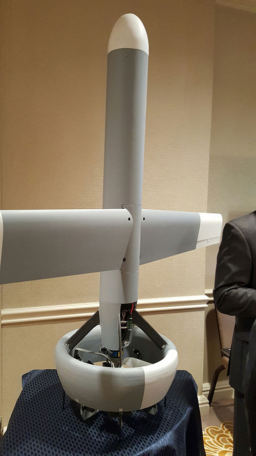
A V-Bat UAV from Martin UAV. Applications include aerial mapping, border patrol, shipboard operations and others.
Worldwide threats will make robotic and autonomous systems’ development important for decades, according to officials speaking at the Unmanned Systems Defense conference late last year.
GPS World’s contributing editor Kevin Dennehy wrote, “Because America has been at war for more than 14 years, unmanned technology has been developing at a rapid rate, perhaps even faster than emerging autonomous commercial systems. The replacement of even manned aircraft has some in the military establishment wary, but others know it’s only a matter of time before most vehicles, surface ships and aircraft are unmanned.”
The Secretary of the Navy said its current manned fighter plane, scheduled to see activity from now until 2037, may be its last to carry an actual human pilot.
The Navy’s Kraken drone munitions delivery system begins its mission underwater,then explodes past the surface to operate in the air. The Air Force also is developing small drones that can be launched and recovered by a larger aircraft after a mission is complete.
An Army initiative called Leader Follower includes rudimentary autonomous convoy operations capability with GPS and base mapping systems, autonomous steering and braking. Army program managers say the program is in staffing, but should be approved in a few months. A full-blown Automated Convoy Operations capability would allow any manned system, including tanks and mobile artillery, to operate autonomously. Last year, the Army and Lockheed Martin successfully demonstrated a driverless line-haul convoy with seven military trucks at speeds up to 40 mph.
Talking about a new generation
Lt. Gen. Michael Williamson, U.S. Army deputy to the assistant secretary of defense for acquisition, said the service is divesting its aging robotics and drone systems, which means future contracts for defense companies. “In 14 years of war, we have rode this equipment pretty hard,” he said. “We believe in modernization, but also looking to buy new systems, which is a new shift in order to gain a competitive advantage over our enemies, who are leveraging unmanned systems.”
The Defense Department recently established the Defense Innovation Unit, based in the San Francisco Bay area, to take advantage of rapid autonomous developments in the Silicon Valley.
Virtually all unmanned systems, from drones to autonomous vehicles, use GPS location technology and advanced mapping. As systems evolve, and enemy threats become more sophisticated, new requirements are emerging.
A surrogate LDUUV is submerged in preparation for a test to demonstrate the capability of the Navy’s Common Control System at the Naval Undersea Warfare Center Keyport in Puget Sound, Washington. (U.S. Navy photo)
In December 2015, the U.S. Navy tested its newly developed Common Control System (CCS) with a submersible unmanned vehicle in underwater missions in Puget Sound, Washington. The CCS successfully demonstrated its capability to provide command and control to a surrogate Large Displacement Unmanned Undersea Vehicle (LDUUV) — an underwater UAV destined for reconnaissance and surveillance missions.
CCS is a software architecture with a common framework, user interface and components that can be integrated on a variety of unmanned systems. It will provide common vehicle management, mission planning and mission management capabilities for the Naval unmanned systems portfolio. Operators used the CCS to transmit pre-planned missions via radio link to the LDUUV’s autonomous controller. In turn, CCS displayed actual vehicle status information to the operators. The vehicle was able to maneuver to the target areas and collect imagery.
“These tests proved that operators could use CCS from a single global operations center to plan, command and monitor UUVs on missions located anywhere in the world,” said Capt. Ralph Lee, who oversees the Navy’s CCS program at Patuxent River, Maryland. “This event also showed us that CCS is adaptable from the UAV (unmanned aerial vehicle) to UUV missions.”
CCS is intended to be compatible across all domains — air, surface, undersea and ground. The Navy initially plans to deploy the CCS on unmanned air vehicles. It will provide common vehicle management, mission planning and mission management capabilities for the Naval unmanned systems portfolio.
By Martti Kirkko-Jaakkola, Stefan Söderholm, Salomon Honkala, Hannu Koivula, Sonja Nyberg, and Heidi Kuusniemi, Finnish Geospatial Research Institute (FGI), National Land Survey of Finland
Our real-time kinematic (RTK) implementation, the Public Precise Positioning (P3-Service) project, has achieved horizontal positioning accuracy of 0.5 meters using relatively inexpensive equipment: a commercial off-the-shelf (COTS) low-cost GNSS receiver. The project used FinnRef, the Finnish national GNSS network.
With inter-station baselines on the order of 200 kilometers, FinnRef is relatively sparse in comparison with commercial RTK networks. We used FinnRef as the RTK base station, either in single-base or network RTK mode. Although FinnRef’s main purpose is to maintain the national coordinate system, it is also capable of delivering DGNSS and network RTK data over the NTRIP protocol.
Transport Applications. Horizontal position accuracy of 0.5 meters or better, achieved for more than 90 percent of the time with small, low-cost devices, could be useful in various applications, particularly in intelligent transportation systems.
Current consumer-grade GNSS solutions routinely offer a positioning accuracy in the order of 5 meters, and satellite-based augmentation systems (SBAS) such as WAAS and EGNOS can improve the accuracy to the order of 1 meter. However, this is not adequate for all use cases; in particular, intelligent transportation systems (ITS) require better positioning performance. For instance, a horizontal accuracy of 0.5 meters is needed to reliably identify the lane in which a vehicle is driving. Maintaining inventory of machines, road signs and other infrastructure would also benefit from sub-meter accuracy.
Sub-meter or even sub-decimeter positioning accuracies can be attained with a relatively good reliability in real time if a dual-frequency GNSS receiver and a physical or virtual base station are available. However, such receivers and virtual base station services are currently too expensive to gain popularity in the mass market. Recently, precise point positioning (PPP) has demonstrated that comparable accuracies can be attained without a base station using real-time precise correction data, but its drawback is a long convergence time. In contrast, differential methods utilizing raw base-station observations, such as RTK, converge much faster.
Horizontal position estimation results from a low-cost COTS receiver (right); the green triangle marks the reference position solution.
Network RTK Test. Network RTK performance was tested in a static scenario with the closest physical base station 63 kilometers from the rover receiver. Network corrections were delivered in the PRS representation, and data were logged for 20 minutes at a rate of 1 Hz. The plot above shows the resulting horizontal position errors. The dashed red circle with a radius of 0.5 meters centered at the reference location (green triangle) contains 90.4 percent of the position estimates.
For a full account of the experiments and results described here, see the paper “Low-Cost Precise Posioning Using a National GNSS Network,” presented at ION GNSS+ 2015.
The new DPS 432 combines decimeter accuracy with high integrity and availability of GNSS data.
Kongsberg Maritime has introduced a new position reference system that integrates all available GNSS and all possible correction services. The new DPS 432 combines full decimeter accuracy with high integrity and availability of GNSS data, supporting the safety and efficiency of offshore operations that rely on advanced dynamic positioning (DP) systems.
The DPS 432 integrates signals from GPS, GLONASS, BeiDou and Galileo, and regional correction signals including SBAS (WAAS, EGNOS, MSAS, GAGAN), in addition to the new G4 services from Fugro, to ensure high flexibility for DP operations globally.
Because DPS 432 exploits available combinations of GNSS signals, it is suited to complex operations in challenging environments. The system increases satellite availability, improves integrity monitoring and enables more precision under challenging signal tracking conditions, Kongsberg said.
The new DPS 432 will be part of the Kongsberg DPS portfolio of products that meet requirements for operations in any geographical region.
“DPS 432 expands our established and field-proven portfolio of position reference systems for DP operations, ensuring that we can offer a highly reliable solution for any DP vessel or operating region,” said Vidar Bjørkedal, VP sales and customer support, Kongsberg Seatex. “The system is based on the same architecture as other DPS products, which means it features a highly intuitive HMI [operator interface], while the ability to integrate all available GNSS and corrections provides integrity and availability of the position data needed for safe operations.”
The DPS 432 features the sophisticated DPS NAV Engine used in all DPS solutions, which runs critical computations independent from the DPS HMI to ensure continuous and reliable operation. The DPS NAV Engine runs in a safe mode, protected from unintended user operations, while several DPS HMIs can be connected to the same DPS NAV Engine in a networked architecture.
Straightforward operation to enhance DP operations safety further was a key design goal during development of DPS 432. The system can integrate multiple layers of information, giving the DP operator opportunities for a customized visual presentation, including electronic charts, seabed maps, well-head positions, static targets and Automatic Identification System (AIS) target information.
Anatum Field Solutions (AFS) has launched a nationwide BYOD (Bring Your Own Device) submeter GNSS and centimeter (RTK) GNSS receiver rental program. With the explosion of smartphones and tablets in recent years and the availability of universal Bluetooth submeter and real-time kinematic (RTK) GNSS receivers, high-accuracy GNSS data collection is available to everyone.
AFS rentals target high-accuracy users in GIS, UAV, environmental, engineering, surveying, agriculture, electric/gas/water utilities, pipeline, forestry, mining, transportation, construction, architecture, and federal/state/local government markets.
AFS offers all mobile GIS devices including Apple iOS, Android, Windows and Windows Mobile/EHH. It also stocks various GNSS receivers such as Eos Arrow (submeter and centimeter), SXBlue (submeter and centimeter), Trimble R1 (1 meter) and BadElf (1-3 meters) in a variety of configurations.
“We intend to make centimeter and submeter accuracy GNSS receivers available to everyone, even if you only need it for a couple of days,” said Matt Alexander, Vice President at AFS. “Our full rental systems come complete with GNSS receiver, tablet with cellular data, data collection software and accessories. You can literally be collecting centimeter-accurate data within minutes of opening the box, no matter what your experience level is.”
AFS can accommodate a wide variety of mobile GIS software solutions with its systems, including Esri’s ArcGIS Collector, Survey123 and ArcPad; iCMTGIS; TerraGo; AmigoCloud; Avenza PDF Maps; Fulcrum; and tMap. AFS provides the software tools and technical support to turn mobile GIS software into centimeter or submeter-accurate data-collection systems.
AFS offers three different rental configurations:
Complete systems including GNSS receiver, tablet computer with cellular data plan, mobile GIS software and accessories. Ready to map.
GNSS receiver and tablet computer with cellular data plan (user logs into their own mobile GIS account).
GNSS receiver (centimeter or submeter) only. Ready to connect to your mobile device.
All rentals come with a return shipping label so the user can leave the box at a FedEx pick-up location, hotel counter, office counter or anywhere that Fedex picks up.