Category: Applications

  • AAGS launches geodetic surveying certificate: Key updates from joint NGS/NSPS/AAGS meeting

    AAGS launches geodetic surveying certificate: Key updates from joint NGS/NSPS/AAGS meeting

    As president-elect of the American Association for Geodetic Surveying (AAGS), I participated in a joint quarterly meeting with the National Geodetic Survey (NGS), the National Society of Professional Surveyors (NSPS) and AAGS on April 25.

    I invite you to visit the AAGS website and consider joining our monthly board meetings, which are held on the second Tuesday of each month. All are welcome to attend. If you are interested, email me at [email protected] to be added to the attendee list.

    Now, for some updates from the joint quarterly meeting.

    During the meeting, I provided an update on the Certificate for Geodetic Surveying program, which has been under development by AAGS and is expected to be available by the end of the year. The program is designed to meet the needs of surveyors and others that perform spatial analyses and computations using geodetic methods.

    Tim Burch, executive director of the National Society of NSPS, wrote the following in an April 23, 2025, xyHt article:

    “To the average professional surveyor, the term “geodesy” does not exist in their everyday conversations about the business. While the use of state plane coordinates has expanded greatly with the development of GPS/GNSS receivers and RTK/RTN connectivity, the mathematics and “black magic” of geodesy remains an enigma to most of the profession.

    However, the ongoing progression of technology within surveying instruments has expanded the need for understanding how geodesy works. Our practitioners are faced with expanding their knowledge and expertise of geodesy and thus have put a new challenge on them to find teachers and/or mentors to provide training on the datums and techniques.”

    This is exactly what AAGS is attempting to do with the Certificate for Geodetic Surveying program. The information below includes the program description and content. AAGS has developed a set of questions that will determine if an individual has demonstrated a minimum competence in understanding and applying geodetic surveying concepts. AAGS is working with NSPS, who will be administrating the program for AAGS. The status and updates of this program are provided at the AAGS Monthly Board meetings. Come join us to hear more about the program and other AAGS activities.


    Certification for Geodetic Surveying

    Program description and content. Certification for Geodetic Surveying is official recognition that a person has demonstrated to the satisfaction of the Certification for Geodetic Surveying Board that he or she is minimally competent to perform spatial analyses and computations using geodetic methods.  It is not intended to certify scientists performing research in geodesy.  Rather, it is for individuals who use geodetic concepts and techniques to solve practical problems as a part of performing their work.  Typical practitioners include geodetic surveyors, geodetic/geomatics engineers, geospatial software developers, geographic information systems (GIS) professionals, and geospatial data managers.  The focus is more on the use of applied geodetic methods than with a particular field.  A person who has obtained the Certification for Geodetic Surveying is one who has demonstrated minimum competence.  In this context, “minimum competence” is a combination of working knowledge and familiarity with geodetic concepts that shows the ability to understand and solve applied practical geodetic problems as normally encountered in modern geospatial practice.  Importantly, this includes an understanding of one’s limitations in solving such problems. 

    The Certification for Geodetic Surveying Board will identify the depth of knowledge required to achieve minimum competence for Geodetic Certification in the following areas:

    • Geometric geodesy
      •  Reference frames, reference systems, geometric datums, and realization strategies
      • Characteristics of modern reference systems, including NAD 83, WGS 84, ITRF, and IGS
      • Transformations between datums, both modern and historic
      • Geodetic, projected, and local geodetic horizon coordinate systems
        • Direct and inverse problems for geodesics and map projections
        • Reference ellipsoids, radii of curvature, and types of geodetic and projected distances
        • Reductions, conversions, and relationships between coordinate systems
        • Transformations used to create “localization/calibration” coordinate systems
    • Physical geodesy
      • Gravity, “the” geoid, gravimetric and “hybrid” geoid models, physical height systems, deflection of the vertical
      • Vertical geodetic datum definitions and transformations
      • Types of heights and their relationships; conversions between the various types
      • Terrestrial methods for vertical, horizontal, and 3-D positioning
        • Geodetic leveling and height determination; leveling instrumentation and corrections
        • Modern 3-D terrestrial methods and instruments, including total stations and scanners
        • Familiarity with historical methods such as triangulation, trilateration, and geodetic astronomy
    • Accuracy and error
      • Positional error estimation and uncertainty propagation; statistics and probability theory
      • Characterization using network and local accuracies, error ellipses, and confidence levels
    • Temporal aspects
      • Plate tectonics (both steady-state and episodic); plate-fixed versus no-net rotation reference systems; subsidence; isostatic adjustment; tidal deformation
      • Time-dependent transformations between reference systems
    • Global Navigation Satellite Systems (GNSS)
      • Instrumentation; system architecture; signal structure; error budget
      • Methods for position determination, including by pseudorange, differential correction, carrier-phase differencing, and precise point positioning
    • Geodetic survey networks
      • Design, adjustment, and analysis of GNSS and terrestrial geodetic survey networks
      • Formulation and solution of least-squares network adjustments
    • Standards and guidelines
      • Official standards, specifications, and guidelines for geodetic control, positioning, and accuracy
      • The US National Spatial Reference System and similar systems elsewhere

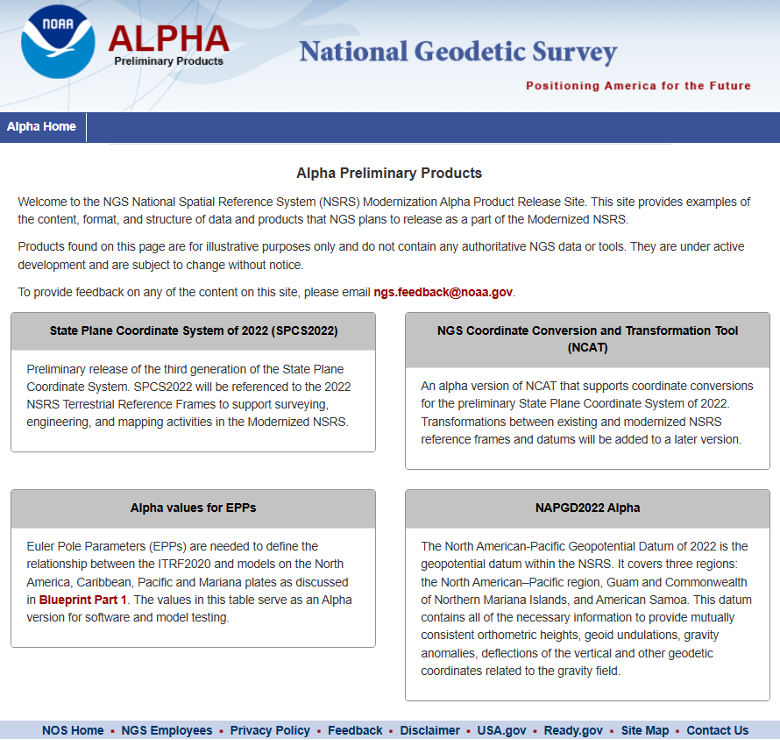
    Many of you are probably aware of the actions taken by the current administration to reduce the size of the U.S. federal workforce, these actions may affect all users of U.S. geospatial products and services.  NGS is not exempt from these actions; recently, they have lost many employees either though leaving service voluntarily, retiring earlier than planned, or having been terminated because they were still in the probation period of their employment. NGS leadership did not provide any details on changes in personnel; only time will tell what the loss of personnel will have with the agency in the future. That said, NGS’s plans still include transitioning the modernized NSRS Alpha Site to a Beta Site this year. The current alpha site has four products — State Plane Coordinate System. SPCS2022, NGS Coordinate Conversion and Transformation Tool (NCAT), Euler Pole Parameters (EPPs) and The North American-Pacific Geopotential Datum of 2022. My understanding is that all four of these alpha products will be transitioned to beta products sometime in 2025. Some may have limited options in the beginning. 

    During this period, the beta site will provide the content, format and structure of data and products that should not change much from the final product. There could be minor changes detected during the beta phase, but users should not anticipate large significant changes. That said, that is why you have a beta phase before production. It is important for users to access the beta products and identify any issues or concerns and provide feedback to NGS. Future newsletters will highlight the beta products as they are released.

    NGS Alpha Site (Photo: NGS website)
    NGS Alpha Site (Photo: NGS website)

    Finally, I would like to highlight a NGS webinar held on April 25, “Design of Networks Using NOS NGS 92.”  Dave Zenk, NGS Northern Plains Regional Advisory, gave a good presentation outlining the tables that users need to be familiar with using OPUS Projects to process and submit GNSS projects to NGS for publications. The webinar provided a few examples to explain the concepts.  Users can download the webinar from NGS webinar website.

    Design of networks using NOS NGS 92. (Photo: NGS website)
    Design of networks using NOS NGS 92. (Photo: NGS website)

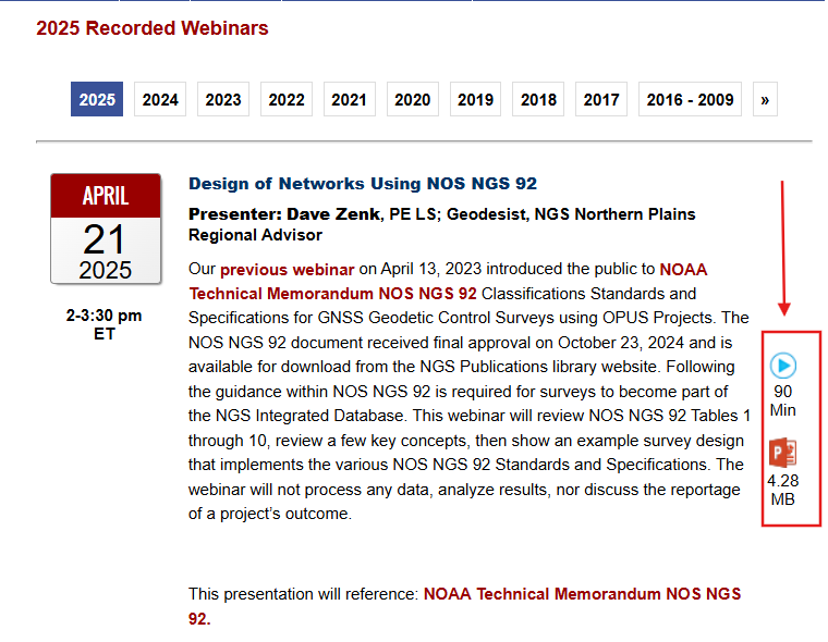
    I found the webinar to be very informative, and I would encourage all users of OPUS Projects to download the presentation.  During the webinar, Dave briefly mentioned three items that I believe deserve more explanation for anyone using OPUS Project. I will address the following topics in more detail in future newsletters:

    • The mark’s classification — primary, secondary, and local – will not be included on the NGS datasheet but the local and network accuracy from the project will be provided on the datasheet.  What does this mean to someone that’s using the mark in their project?
    • OPUS Project uses the F statistic test to determine if the appropriate constraints were imposed during the horizontally and vertically constrained adjustments.  Why does OPUS Project use this statistic?
    • The Constraint Ratio (CR) test computed by OPUS Projects provides a way of identifying which coordinates should be constrained and which should not be considered for constraints in the final horizontally and vertically constrained adjustments. What’s the best way to use this table?

    Again, I would like to invite you to check out the AAGS website and consider participating in AAGS monthly Board meetings. If you are interested in attending the meeting, send an email to me at [email protected]

    Finally, users should continue to check NGS’s website for the announcement of the transition from the alpha site to the beta site. Future newsletters will highlight the beta products as they are released.

  • Inertial Labs, a VIAVI Solutions company, launches tactical-grade MEMS IMU

    Inertial Labs, a VIAVI Solutions company, launches tactical-grade MEMS IMU

    Inertial Labs, a VIAVI Solutions company, has released the IMU-H100, a micro-electromechanical systems inertial measurement unit (IMU) designed to improve tactical guidance and navigation for UAVs, short-range missiles, precision-guided munitions and a range of commercial applications.

    As technology for unmanned vehicles advances and safety considerations take precedence, both military and commercial sectors are increasing their adoption of IMUs, which are critical for navigation and control systems. An IMU can track angular velocity and linear acceleration using MEMS gyroscopes and accelerometers. These devices are now considered essential for guidance, navigation, orientation and stabilization, especially in short- and medium-range flight control systems. Their applications extend to autonomous vehicles operating on land, at sea and in aerospace and defense sectors.

    The IMU-H100 is a tactical-grade unit that features accelerometers and gyroscopes on all three axes. It offers a gyro bias of 1° per hour and an accelerometer bias of 1 mg. The unit measures 5 cubic inches and weighs 160 g. According to the company, the IMU-H100 surpasses comparable products in data rate, measurement range, stability and repeatability, even under challenging conditions such as vibration, shock, high acceleration, spinning, temperature changes and acoustic noise.

  • US Army selects AEVEX Aerospace for short-range launched effects demonstration

    US Army selects AEVEX Aerospace for short-range launched effects demonstration

    The U.S. Army has selected AEVEX Aerospace to participate in the Launched Effects-Short Range Special User Demonstration, an initiative aimed at advancing the Army’s integration of sophisticated uncrewed systems to improve battlefield effectiveness. AEVEX will present its Atlas Group II launched effect during the demonstration, a lightweight and agile system engineered for precision missions that directly support frontline troops. The Atlas system reflects AEVEX’s commitment to developing innovative technologies that address the Army’s evolving operational threats and mission requirements.

    Throughout the demonstration, soldiers from various Army branches — including field artillery, infantry, and aviation — will operate the Atlas system to refine tactics, techniques and procedures. Their hands-on feedback will play a critical role in shaping how the Army employs launched effects in the future, influencing both requirements and operational strategies.

  • ProStar, Emlid partner for cm accuracy for critical infrastructure mapping worldwide

    ProStar, Emlid partner for cm accuracy for critical infrastructure mapping worldwide

    ProStar Holdings, developer of the PointMan Precision Mapping Solutions, and Emlid Tech, European maker of high-precision GNSS equipment, are partnering to bring centimeter-level precision and cost-efficiency to mapping of underground utilities and other critical infrastructure.

    The strategic partnership offers ProStar’s PointMan platform, powered by Point One RTK correction services with Emlid’s lightweight and survey-grade GNSS receivers. By combining PointMan’s cloud and mobile precision-mapping solution with Emlid Reach receivers, Emlid’s end-users anywhere in the world have access to an affordable, centimeter-accurate mapping solution.

    Emlid offers a range of cost-efficient and lightweight utility mapping equipment. The Emlid Reach RX is a pocket-sized high precision RTK GNSS receiver providing fast setup with no configuration required. For precision mapping trenches in challenging conditions, the Reach RS3 can be used as a base or a rover and provides centimeter-level geopositioning with tilt compensation.

    PointMan with Point One RTK corrections provides an easy-to-use mobile mapping solution that uses more than 2,000 base stations communicating with all four major satellite constellations.

    “We’re thrilled about this partnership,” said Dmitriy Ershov, Director of Business Development at Emlid. “PointMan mobile mapping software is well-recognized for its versatility and ease of use, and it is exciting to see PointMan continue to evolve, especially with the inclusion of Point One RTK. We are delivering survey-grade accuracy to professionals worldwide in a simple, all-in-one solution.”

    Page Tucker, CEO and founder of ProStar, added, “We are strategically aligning with several leading equipment manufacturers to establish a global distribution network. Emlid’s GNSS receivers, combined with PointMan powered by Point One, create a comprehensive and affordable precision mapping solution with unmatched accuracy, coverage, and performance that empowers Emlid’s customers worldwide.”

  • NATO tests prototype sensor against GNSS signal threats

    NATO tests prototype sensor against GNSS signal threats

    A new prototype sensor developed by the NATO Communications and Information Agency has completed a significant round of testing, marking a step forward in NATO’s electromagnetic warfare capabilities. The sensor, GANDALF 4, underwent a series of tests at an advanced anechoic chamber operated by the NATO Support and Procurement Agency. This facility serves as a controlled environment for precise calibration and detailed performance assessment of the sensor’s antenna array, which is critical for ensuring the system’s accuracy and reliability.

    GANDALF 4 was developed by specialists at the agency’s Joint Intelligence, Surveillance and Reconnaissance Centre. The system is designed to detect, classify and locate deliberate attempts to interfere with or manipulate GNSS signals. GNSS jamming and spoofing are becoming more frequent and sophisticated, posing challenges to NATO’s operational readiness and resilience. The development of GANDALF 4 is designed to enhance situational awareness in contested electromagnetic environments.

    The recent testing phase focused on evaluating the antenna performance of the sensor. Collaboration between the agency’s Electromagnetic Warfare and Surveillance team and the procurement agency’s Ground Based Defence group played a central role in the campaign, facilitating knowledge transfer and improving efficiency, according to the team.

  • Q-CTRL demonstrates quantum navigation system as GPS backup

    Q-CTRL demonstrates quantum navigation system as GPS backup

    A team of researchers at Q-CTRL, a quantum infrastructure software company based in Sydney, Australia, has completed a successful demonstration of a new quantum navigation system called Ironstone Opal. The group described the system’s operation and performance in a paper posted to the arXiv preprint server.

    GPS technology is widely used for navigation in both civilian and military vehicles and aircraft. However, the increasing reliance on GPS has highlighted its vulnerability to outages, which can leave drivers stranded, force pilots to rely on outdated methods and complicate the deployment of military assets. These concerns have driven efforts worldwide to develop robust backup systems or alternatives to GPS.

    Q-CTRL’s Ironstone Opal is designed as a backup navigation system and, according to the research team, can deliver accuracy up to 50 times greater than existing GPS backup systems in certain scenarios. The system leverages quantum sensors that are highly sensitive to variations in the Earth’s magnetic field. Because the magnetic field differs depending on geographic location, these sensors can precisely determine an object’s position by reading the field and using artificial intelligence-based software to generate geographic coordinates similar to those provided by GPS.

    The research team shared that unlike conventional systems, Ironstone Opal is passive, meaning it does not emit signals that could be detected or jammed by adversaries. The system’s software is designed to filter out noise from vehicles or aircraft carrying the sensors, and the hardware is compact enough for installation in cars, trucks, UAVs and aircraft.

    Field trials conducted by Q-CTRL included both ground vehicles and aircraft. The results showed that Ironstone Opal outperformed a high-end inertial navigation system, a standard GPS backup, by up to 50 times in ground tests and by at least 11 times in airborne tests. These trials demonstrated the system’s ability to maintain high accuracy under a range of environmental conditions, altitudes, and maneuvers, with positioning uncertainty as low as 0.01% of the total distance traveled in the best cases.

    Q-CTRL’s approach combines proprietary quantum magnetometers with advanced denoising and map-matching software, allowing the system to detect subtle magnetic “landmarks” in the Earth’s structure. The technology is designed to be resilient, unjammable, and suitable for integration into a wide range of platforms, including autonomous vehicles and commercial aircraft.

  • Beyond Gravity supplies high-power antenna for ESA mission

    Beyond Gravity supplies high-power antenna for ESA mission

    On April 29, the European forest satellite “Biomass” was launched into space from Kourou aboard a European Vega-C rocket operated by Arianespace.

    The company Beyond Gravity, based in Zurich, Switzerland, supplied several key products for this mission. Its high-power antenna and navigation receiver will provide the satellite’s precise position in orbit. Also, the satellite will be protected by the company’s thermal insulation.

    The European Space Agency’s (ESA) “Biomass” mission will measure forest biomass and will observe the state and development of forests and advance our knowledge of the carbon cycle. Knowing the amount of carbon bound up in forest biomass will sharpen our understanding of climate change and its likely effects on the global carbon cycle. The satellite will orbit Earth at an altitude of 666 kilometers. The mission’s expected lifetime is at least 5.5 years.

    “Forests are the green lungs of our planet, providing us with oxygen and storing carbon dioxide,” said Oliver Grassmann, Executive Vice President Satellites at Beyond Gravity. “With the environmental satellite Biomass, we are learning more about the importance of forests to our climate system. Contributing to the functioning of such a groundbreaking climate satellite with key products, like various antennas, our navigation receiver and our multi-layer thermal insulation is a great honor and extremely inspiring for all our colleagues.”

    The Biomass mission will feature a new high-power antenna from Beyond Gravity that serves the data downlink needs of new Earth-observing satellites as they gather ever larger quantities of environmental data. The antenna has the size and shape of a large ice cream cone. While more and more Earth observation data from satellites is gathered, the satellite itself becomes smaller. Thus, there was a clear need for a smaller, more powerful data downlink antenna.

    The X-band helix antenna design was developed for ESA by Beyond Gravity’s site in Gothenburg, Sweden. Beyond Gravity also provided the S-Band TTC (telemetry, tracking and command) antenna, which acts as a communication and control antenna for the satellite.

    A new antenna from Beyond Gravity for data downlink will serve Biomass. It was developed through an ESA General Support Technology program contract with Beyond Gravity in Sweden. (Photo: ESA, Beyond Gravity)
    A new antenna from Beyond Gravity for data downlink will serve Biomass. It was developed through an ESA General Support Technology program contract with Beyond Gravity in Sweden. (Photo: ESA, Beyond Gravity)

    Precise in-orbit position determination. The satellite’s position in space is determined to within centimeters using technology from Beyond Gravity’s site in Vienna, Austria. The more accurate the positioning, the more accurate the data provided by the satellite.

    The receiver can process both GPS and Galileo signals. Beyond Gravity’s navigation receivers determine the position of approximately 25 satellites in space. The Beyond Gravity site in Tampere, Finland, produced the Reflector Deployment Interface Unit.

    Multi-layer thermal insulation from Beyond Gravity made out of several layers of ultra-thin special polyimide foils will keep the satellite’s instruments at the required operating temperature despite the  harsh thermal environment in space. Nearly every European ESA satellite is protected by thermal insulation from Beyond Gravity, which is designed and produced at the company’s sites in Austria. Beyond Gravity also produced the Eddy Current Damper, which is part of the spacecraft’s solar array wing and is providing the damping to slow down the deployment and prevent shocks at deployment completion.

  • TrustPoint secures NAVAIR contract for C-band GNSS receivers

    TrustPoint secures NAVAIR contract for C-band GNSS receivers

    The United States Navy’s Naval Air Systems Command (NAVAIR) has awarded TrustPoint a $1.2 million Small Business Innovation Research Phase II contract. The funding supports the initial delivery and demonstration of TrustPoint’s C-band GNSS service-enabled receivers for the U.S. government. TrustPoint is collaborating with Hexagon U.S. Federal and NovAtel, both part of Hexagon.

    This project combines TrustPoint’s C-band services with NovAtel’s GNSS receiver technology, aiming to advance resilient positioning, navigation and timing solutions for military use. The partnership draws on extensive experience in military-grade GNSS equipment and services, and represents a significant step in developing technology that can operate reliably in challenging operational environments.

    The contract highlights the increasing importance of frequency and orbital diversity for future navigation and timing needs. With Hexagon as a key partner, TrustPoint is positioned to address the Department of Defense’s evolving requirements for assured PNT, supporting mission continuity even in contested environments

  • Hydro-Tech unveils multibeam echosounder for USVs

    Hydro-Tech unveils multibeam echosounder for USVs

    Hydro-Tech has unveiled the MS400C, a fully integrated multibeam echosounder designed for uncrewed surface vessels. The new system combines sonar processing, inertial navigation, GNSS positioning and sound velocity sensing into a single unit.

    The MS400C seeks to address deployment challenges faced by USV operators during hydrographic surveying. Its compact, lightweight design allows direct mounting on small platforms. Installation involves connecting a few cables to the IPC and power supply and to the primary and secondary GNSS antennas. With preconfigured spatial relationships, operators can deploy and start surveying quickly, reducing configuration errors and ensuring consistent data quality. Equipped with Auto Survey functionality, the system calibrates parameters based on water conditions, which streamlines pre-survey procedures. Real-time roll compensation and attitude data from the internal IMU, combined with sound velocity profiling, ensure high-fidelity depth measurements, even in dynamic conditions. Designed for autonomous and remotely operated survey platforms, the MS400C supports data collection in confined waterways.

  • Teledyne Marine launches autonomous navigation solution

    Teledyne Marine launches autonomous navigation solution

    Teledyne Marine has launched the Teledyne Compact Navigator, an ultra-compact autonomous integrated navigation system engineered for subsea and surface vehicles. It is ideal for small vehicles, enabling inspection and survey operations on compact platforms. The system is offered in two depth-rated models, one capable of operating at 4,000 m and another at 300 m. The Compact Navigator consumes less than seven watts of power, extending mission duration by conserving energy. The system operates fully autonomously, eliminating the need for external aiding or operator intervention. Advanced phased array Doppler Velocity Log (DVL) technology enhances performance while allowing the device to be mounted on an autonomous underwater vehicle or ship hull.

    Compact Navigator supports a broad range of applications, including ROVs, AUVs, shallow water surface navigation, operations in GNSS-denied environments and dynamic positioning for surface vehicles. The system provides true North-seeking gyrocompass-grade performance, and its web-based user interface supports integration, operation, and troubleshooting. It is factory-calibrated and offers a battery backup option for reliability in demanding conditions. The system operates independently of satellite signals, making it resistant to jamming or signal loss. This capability is significant for shallow water navigation, where GNSS-based systems may be unreliable.

  • Launchpad: Latest in OEMs, mapping, UAVs and more

    Launchpad: Latest in OEMs, mapping, UAVs and more

    Read a roundup of recent products in the GNSS and inertial positioning industry from the April 2025 issue of GPS World magazine.


    OEM

    INS
    With three additional GNSS receiver variants

    Photo: Topcon
    Photo: Topcon

    SBG Systems has upgraded its inertial navigation systems — Ekinox, Apogee and Navsight — with new GNSS receiver options. The latest update introduces three additional GNSS receiver variants.

    These include:

    • Marinestar, which supports Fugro Marinestar, delivering precise point positioning (PPP) with centimeter-level accuracy via L-band corrections without requiring a base station. It is optimized for marine applications.
    • HAS Ready / NavIC, which includes Galileo E6 support for the upcoming Galileo High Accuracy Service (HAS), offering free decimeter-level PPP corrections globally. Additionally, it supports the Indian NavIC system.
    • Centimeter-Level Augmentation Service, which is tailored for users in Japan; this variant utilizes QZSS L6 signals to provide free PPP corrections without external services.

    All GNSS variants integrate seamlessly with SBG Systems’ antenna portfolio and Qinertia post-processing software. Users select the appropriate GNSS variant at purchase to match their operational requirements. These enhancements aim to provide versatile solutions across diverse industries while ensuring reliable performance.

    SBG Systems

    Receivers
    Can achieve centimeter-level accuracy

    Photo: STMicroelectronics
    Photo: STMicroelectronics

    The GNSS receivers in the Teseo VI family use multi-constellation and quad-band signal processing on a single chip, achieving centimeter-level accuracy for various applications. The Teseo VI family includes the STA8600A and STA8610A models. These receivers are designed for automotive applications such as advanced driver assistance systems and autonomous driving, as well as industrial uses, including asset tracking, mobile robots and precision agriculture.

    The Teseo VI+ variant can host enhanced positioning engines developed by third-party companies, providing real-time kinematics for centimeter position accuracy.

    STMicroelectronics

    GNSS Module
    Operates in challenging environments

    Photo: Quectel
    Photo: Quectel

    The LG680P is a multi-constellation, quad-band GNSS module designed for high-precision positioning and to enhance signal quality and precision through concurrent reception of L1, L2 and L5 frequency bands. It supports Galileo E6, QZSS L6 and BDS B2b signals for precise point positioning, ensuring horizontal accuracy of up to 0.8 cm + 1 ppm without requiring local or broadband connectivity.

    To ensure signal integrity in environments with electromagnetic interference, the module features professional-grade anti-jamming technology, including built-in NIC algorithms that suppress narrow-band interference. It supports external active antennas for enhanced signal reception and positioning accuracy. It is ideal for applications such as autonomous lawnmowers, delivery robots, surveying equipment and precision agriculture. Quectel complements it with two external GNSS antennas: the YEGR001W8AH geodetic antenna and the YEGD006U1A compact patch antenna.

    Quectel

    Firmware Upgrade
    For SBG Systems’ MEMS-based INS

    Photo: SBG Systems
    Photo: SBG Systems

    The New Ellipse firmware upgrade for the Ellipse product line allows the system to now be used as an attitude and heading reference system or inertial navigation system. It is designed to enhance navigation, attitude and heave performance for stable and accurate positioning, even in challenging conditions.

    It introduces advanced GNSS-denied capabilities, featuring newly integrated flags that trigger when GNSS jamming or spoofing threats are detected. This allows users to reject or re-enable external sensors — such as GNSS — without resetting the filter. The user-friendly interface allows for fast and flexible configuration using simple command lines, enabling users to tailor the Ellipse to their specific needs and applications.

    SBG Systems

    Localization Solution
    Operates in GNSS-denied environments

    Photo: OxTS
    Photo: OxTS

    WayFinder is a localization solution designed for GNSS-denied environments. It integrates a GNSS/INS system, onboard processor, lidar scanner and two cameras, enabling precise navigation in areas with limited satellite coverage. The system features Lidar Boost, a software technology that enhances GNSS/INS performance by processing lidar data to compensate for missing or inaccurate GNSS updates in real time. This ensures high-accuracy localization and seamless transitions between GNSS-supported and GNSS-denied environments.

    WayFinder enables precise navigation for autonomous vehicles in ports, mining and indoor automotive testing without fixed infrastructure. It also provides reliable positioning for surveyors in areas with limited GNSS coverage.

    OxTS

    Survey

    Smart Surveying
    Introduces topographic design tools

    Photo: Virtual Surveyor
    Photo: Virtual Surveyor

    Virtual Surveyor Version 10 introduces Basic Topographic Design tools, allowing users to document terrain changes such as graded roads, water ponds and building surfaces. The software now features four subscription plans — Valley, Ridge, Mountain and Peak.

    • Ridge plan: Focuses on surveying a single moment in time using one drone data set.
    • Mountain plan: Adds Timelines to compare surveys across different times, visualizing changes through Time Steps.
    • Peak plan: Includes advanced Topographic Design tools for planning future structures by creating new Time Steps. These tools allow users to design features such as roads or ponds directly on UAV-derived models, with automated alignment and volume calculations for cut-and-fill operations.

    Version 10 introduces drawing guides, available in the Ridge plan and above, enabling precise drawing of points at specific intervals or angles. Walk Mode, included in all plans, allows users to explore 3D terrain at ground level for better visualization. Timelines, featured in the Mountain and Peak plans, facilitate the comparison of multiple surveys conducted at different times and the integration of future designs. These improvements seek to streamline processes for engineering surveyors, supporting applications in construction, mining and water management.

    Virtual Surveyor

    Laser RTK
    With a laser range of up to 50 m

    Photo: ComNav Technology
    Photo: ComNav Technology

    The Jupiter Laser RTK integrates GNSS, auto-IMU, laser and dual camera systems into a single unit. It incorporates a precise green laser that remains visible even in bright daylight. This feature allows for precise measurements of points in hard-to-reach, signal-blocked or potentially hazardous locations. It also features a night vision camera, allowing users to see feature points even in low-light conditions. The RTK system’s laser range is up to 50 m, making it suitable for challenging surveying environments. It incorporates visual technology to offer surveyors an immersive experience during surveying and stakeout operations, improving working efficiency and productivity.

    ComNav Technology

    UAV

    UAV Software
    With new mapping capabilities

    Photo: AgEagle Aerial Systems
    Photo: AgEagle Aerial Systems

    Version 2.1.0 of AgEagle Aerial Systems’ eBee VISION application software introduces circular and grid mapping features, allowing users to generate 2D or 3D maps using external post-processing software for more comprehensive geospatial data.

    The eBee VISION 2.1.0 can continue missions in GNSS-denied environments and allows manual deactivation of GNSS to prevent jamming or spoofing. It implements the STANAG 4609 standard, the official format for motion imagery exchange within the NATO nations. This involves embedding UAV position and camera information into the videos recorded by the UAV and those broadcasted by the Ground Control Station. Its inclusion in the system seeks to enhance interoperability with third-party applications, which is key for military-grade UAVs.

    It offers enhanced control over the Silent Tactical Landing feature. Users can now manually adjust the landing position on the map, with the system providing range estimates to inform operators of the UAV’s reach. This functionality offers greater flexibility in mission planning and execution, particularly in tactical scenarios requiring precise landing control. The system is ideal for defense, public safety and utilities applications.

    AgEagle Aerial Systems

    ‘Drone-in-a-Box’ Solution
    Designed for vehicle-mounted deployments

    Photo: DJI
    Photo: DJI

    The DJI Dock 3 “drone-in-a-box” solution is designed for vehicle-mounted deployments and 24/7 remote operations in various environments. This system is compatible with the Matrice 4D and Matrice 4TD UAVs, which feature advanced cameras and IP-rated protection for challenging conditions. The UAVs are ideal for public safety, emergency response and infrastructure inspection.

    This system supports flexible deployment options, including vehicle-mounted setups optimized for emergency operations and long-distance inspections. It enables horizontal calibration and cloud-based dock location adjustments. Two docks can be mounted on a single vehicle to facilitate dual-UAV rotations for enhanced efficiency. In fixed deployments, the D-RTK 3 Relay Fixed Deployment Version can be added to improve video transmission and satellite connectivity.

    The Matrice 4D and 4TD UAVs have a wide-angle camera, medium tele camera, tele camera and laser range finder. The Matrice 4D features an advanced camera suite designed for high-precision mapping. The Matrice 4TD includes an infrared thermal camera for public safety and emergency response applications. The system includes a Flight Termination System to support regulatory compliance in strictly controlled airspace. This system can manually or automatically stop drone operations if necessary.

    DJI

    Software Upgrade
    Enables 24/7 BVLOS operations

    Photo: uAvionix
    Photo: uAvionix

    Casia G Release 4.0 is a software update that enables nighttime detection of aircraft, allowing 24/7 beyond visual line of sight (BVLOS) UAS operations. The update supports BVLOS flights up to 400 ft at night without requiring hardware modifications, offering detection of both cooperative and non-cooperative aircraft. The system detects aircraft at distances of up to 16.7 km with 360° coverage, ensuring safe nighttime operations. When multiple units are used, triangulation technology provides accurate range, altitude and satellite data for intruding aircraft. The update leverages existing hardware to detect navigation and anti-collision lights at night.

    uAvionix

    Marine Radar
    With W-band radar technology

    Photo: NavTech Radar
    Photo: NavTech Radar

    The MAS10 is a 77 GHz FMCW marine radar system designed to enhance navigation safety in congested environments under all weather conditions. The ultra-high-definition W-band radar provides centimeter-level resolution, enabling vessels to detect and identify small hazards in heavily trafficked waterways.

    Unlike optical and infrared sensors, W-band radar technology penetrates fog, heavy rain and snow, ensuring reliable detection. It operates effectively in low-visibility scenarios, including complete darkness, intense sunlight and shadowed areas where cameras and lidar may struggle.

    NavTech Radar

    Mapping

    New 3D Scanners
    Available in two versions

    Photo: 3DMakerpro
    Photo: 3DMakerpro

    The Eagle Series line of spatial 3D scanners feature lidar and imaging sensors and are designed for various applications, including reverse engineering, digital twinning, asset management, extended reality, precision mapping and 3D printing.

    The series offers scanning capabilities with a range of up to 140 m and precision within 2 cm at 10 m. The lightweight scanner is designed for portability, with a built-in battery providing up to one hour of continuous use.

    The scanners are available in Standard and Max versions. The Max model features four 48 MP cameras, enhancing scanning efficiency and producing vivid 8 K panoramic photos. With a point cloud frequency of 200,000 points per second, the Eagle Series is designed for applications requiring highly detailed spatial data.

    3DMakerpro

    Upgraded Mapping Package
    With Google Maps downloads

    Photo: Golden Software
    Photo: Golden Software

    Golden Software has upgraded its Surfer mapping and 3D visualization software. Users can now directly download georeferenced aerial and satellite imagery from Google Maps into projects. The latest version also improves 3D visualization tools, focusing on faster and more intuitive creation of visual models. Users can now colorize 3D drill hole intervals based on text keywords, making it easier to interpret subsurface data. Additionally, contour slices can now be added to the 3D view, offering a clearer representation of data layers.

    Golden Software has released a beta version (30.0.135) that introduces multiple light sources for improved 3D viewing and customizable legends for better map presentation. These updates are designed to streamline workflows for professionals in industries such as environmental consulting, resource exploration and geospatial analysis, simplifying the creation of professional-grade maps and models efficiently.

    Golden Software

  • Advanced Navigation expands US operations by recruiting military veterans

    Advanced Navigation expands US operations by recruiting military veterans

    Advanced Navigation, an Australia-based company, is expanding its presence in the United States by actively recruiting military veterans. The company aims to leverage the unique expertise of former service members to enhance its mission-critical technologies and address the growing demand for assured positioning, navigation and timing (APNT) capabilities across defense, aerospace and critical infrastructure sectors.

    Wayne Prender, former U.S. Army captain and head of global defense at Advanced Navigation, believes warfighters-turned-technologists are central to this mission.

    “Veterans bring more than technical expertise; they understand firsthand the urgency and complexities of navigation in contested spaces. Their experience directly informs how we design, test and implement solutions, delivering capabilities that genuinely enhance mission outcomes and warfighter safety,” said Prender.

    The company recruits veterans with operational backgrounds in submarines, special operations, aviation and electronic warfare to apply their expertise to APNT applications — including unmanned systems, advanced radar, precision strike platforms and secure battlefield communications. Advanced Navigation’s veteran-led business development team collaborates closely with system integrators, program offices and military end users to deliver tailored APNT solutions that meet rigorous performance standards.