Trimble has introduced a new version of its office surveying software — Trimble Business Center Software version 3.00. Trimble Business Center Software version 3.00 is a powerful, next-generation surveying office software suite designed to manage, analyze and process all field survey data, including optical, GNSS and imaging data.
The new version features photogrammetry enhancements, including the ability to process images from the Gatewing X100 unmanned aerial system (UAS). These enhancements provide surveyors with increased visualization and processing capabilities, allowing them to further maximize productivity and create aerial survey deliverables.
“Powerful and intuitive, Trimble Business Center and its integration with UAS data introduces new capabilities to surveyors and represents a significant leap in efficiency. Surveyors, engineers and geospatial data managers can increase their productivity, efficiency and quality of deliverables through the software’s aerial data processing capabilities,” said Erik Arvesen, vice president of Trimble’s Survey Division. “Traditional sites, such as large mines, that in the past have taken days to map using conventional methods can now be accurately modeled in just hours.”
Version 3.00 introduces a new photogrammetry module for importing and working with flight data and images collected from the Gatewing X100 UAS and optical instruments, such as the Trimble S8 with Trimble VISION technology, which integrates calibrated digital cameras to collect survey data, stream video from the perspective of the instrument and capture panoramic still images. Based on software from Inpho, the Trimble Business Center photogrammetry module also provides office surveyors with the capability to process complete mapping projects containing aerial data, GNSS and total station observations. Surveyors can produce deliverables, including georeferenced orthophotos, 3D point clouds and digital surface models directly from Trimble Business Center.
With the ability to integrate photogrammetry with data collected from GNSS receivers, total stations, and digital levels, surveyors can combine aerial images with GNSS measurements on ground control points and 3D laser scans of buildings to precisely, comprehensively and efficiently map large and complex sites.
The new version also introduces 64-bit processing. As a 64-bit application, Trimble Business Center allows surveyors in the office to utilize their computer’s RAM, maximizing the productivity of the surveyor’s workstation, to display large images and point clouds for increased visualization functionality. Users can also display large images seamlessly; images “tile” automatically on import and the displayed resolution adjusts seamlessly as users zoom in and out for superior image viewing.
“Inpho is a proven leader in digital aerial photogrammetry,” said Arvesen. “Trimble has taken that expertise and applied it to the survey market, as we pioneer the development of UAS data integration for surveyors.”
Presentation to the 11th Meeting of the PNT Advisory Board
The following is an abbreviated transcript of Don Jewell’s briefing to the PNT Advisory Board at its meeting on Tuesday, May 7. The slides from Jewell’s briefing and the other briefings to the board are available at pnt.gov under the heading 11th PNTAB meeting.
First, a prefatory note from Don Jewell:
Author Sets the Scene
The old adage “A picture is worth a thousand words” certainly applies to the atmosphere of a PNT Advisory Board meeting. And in this case, so does the oft repeated and entirely inadequate phrase “You had to be there.”
The atmosphere of an Advisory Board meeting is extremely dynamic. You have a very distinguished board of PNT subject-matter experts who are very passionate about their areas of expertise. Some, like Drs. Parkinson and Schlesinger, the co-chairs, have been involved with PNT and GPS matters for 45 years or more. Therefore, the danger of an abbreviated transcript of an emotion-filled briefing is always unsatisfactory at best, because you miss the give and take, the repartee of experts that have invested much of their lives in this arena. So it is important that the reader understand the context of the questions and answers and sidebar conversations that took place before, during, and after the briefing, to put it in context.
It would be easy after reading this transcript and others during the meeting to put the blame for antiquated PNT equipment on the manufacturers. But nothing could be farther from the truth. The truth is, the culprits here are numerous but identifiable. They are:
1. Outdated government regulations, directives and procurement/acquisition procedures that seriously hamper equipment manufacturers from doing their best and updating equipment as necessary.
2. Timelines that totally ignore the dynamics of Murphy’s Law — a law of ever-shrinking timelines battling a glacial process of ever-increasing requirements bounded by antiquated procurement procedures and fiscal indecision.
In the case of military user equipment (MUE), the warfighters, first responders, and government users are the unfortunate recipients of this morass of near-pandemonium and downright confusion. Dynamic and critical user requirements are sacrificed upon the altar of “the program of record” and an agonizingly glacial government bureaucracy. Be assured that the “program of record” delivered exactly what was asked for by the original RFP and subsequent contract award.
Take Rockwell Collins for instance. Rockwell is a great company, building rugged, reliable, precision instruments. I have flown with Rockwell communications and aviation equipment in various aircraft cockpits for the last 40 years, and they are indeed the gold standard in that arena. Rockwell has been delivering GPS military user equipment since 1978 and the company has always delivered exactly what was asked for. The problem is that the operational and refresh cycle for government user equipment needs is inside the acquisition cycle, and unfortunately exceeds it by a factor of ten — hence Murphy’s Law.
The Defense Advanced GPS Receiver (DAGR) was an excellent device when conceived and was the only game in town as regards jamming and spoofing environments. I am confident that Rockwell would have continuously updated the DAGR and made it relevant today, given the opportunity, which they were not.
In my opinion, government regulations in the area of user equipment, especially electronics and highly dynamic technological areas, need to be drastically altered to follow the aircraft procurement cycle. For example, there are probably 50 or more different block versions of the F-16 aircraft, that in truth are radically different. In some respects the “Block 1” F-16 resembles the capabilities of the “Block 50” version only in that it is an airborne vehicle with wings, engine, and a fuselage. Electronically and technically, it is a totally different aircraft. But the contracts for General Dynamics and now Lockheed Martin were not recompeted every time the user requirements, and hence the capabilities of the F-16 changed. I hope you all agree that would be ludicrous — and yet that is exactly the situation with MUE. When the scope changes, the contracts are painfully and laboriously recompeted, with lag times that make the process laughable — if indeed it were not so sad.
Then there is the government’s serious lack of information and training concerning MUE devices. I have been around GPS user equipment for 35 years and yet I am sure I still do not understand all the capabilities of the Precision Lightweight GPS Receiver (PLGR) and DAGR. Imagine how befuddled a young warfighter becomes when given the devices and only a cursory amount of training, that is not only inadequate but sadly many times misleading or just flat wrong.
In our interviews we founds trainers — those that taught warfighters how to use the PLGR and DAGR — who were not aware the unit could be “keyed” or encrypted for greater accuracy. Of course we also found excellent trainers, but they were the exception to the rule. Who trains the trainers?
Although it sounds trite and seems to be a copout, don’t blame the equipment manufacturers for the current state of MUE. Blame the system and then get involved and help us change it to what it should be.
Good morning, everyone.
A special thanks to Jim Miller, Dr. James Schlesinger and Dr. Bradford Parkinson for inviting me to speak this morning on the future trends of PNT user equipment, particularly as it pertains to warfighters and first responders — certainly a subject I have been passionate about for only…oh, let’s say about 35 years.
Why GPS World?
Ever since the agenda for the PNT Advisory Board meeting appeared online, I have been receiving emails and phone calls asking why I was speaking not as one of the IDA (Institute for Defense Analyses) subject-matter experts on GPS but as the Contributing Editor for Defense for GPS World. Frankly, the answer is simple. Wearing the GPS World hat gives me the freedom to say what needs to be said today, whereas the IDA think tank attribution and publication rules, which are absolutely necessary for an FFRDC (Federally Funded Research and Development Center) to operate effectively and efficiently, would unduly restrict my comments.
Plus, for 21 years GPS World magazine has been the publisher of the definitive GPS user equipment survey for global users. It’s free for everyone to use, and it covers PNT receiver information from 55 global manufacturers with data on all aspects of 502 PNT receivers. And it is a great boon for me personally, as I only receive on average about 50+ emails or letters per month from users simply wanting to know what GPS/PNT receiver they should purchase. It is wonderful to be able to point them to the GPS World Receiver Survey.
Also wearing my GPS World hat, I can easily refer to the several thousand warfighter and first responder inputs we have received over the last 10 years — generally expressing what they would like to see in a GPS/PNT receiver or sometimes specifically the Perfect Handheld PNT Transceiver (PHPNTT), which I first wrote about six years ago (and most recently in December) in GPS World magazine.
Top 10 Warfighter – First Responder Requirements for the PHPNTT
Adhering strictly to the latest fad in government briefing formats, it is now time for me to BLUF, or give you the Bottom Line Up Front. However, being a journalist, I also have to hold something back for the end. So here are the top 10 PHPNTT requirements, in order of preference, as submitted over the last 10 years by thousands of warfighters and first responders:
Mil-Spec rugged – solid state drive – no moving parts
Friendly, intuitive, familiar interface – easy to use
Multi-GNSS – All signals available – space and terrestrial
SWAP friendly, long battery life, with solar charger
Real-time 3D map data, NGA, Google, satellite imagery
Not a stand-alone PNT device
Embedded in a computer with multiple communication capabilities – one must be secure
Must be able to download, store and utilize new applications
Software-defined and expandable
Act as a sensor with automatic reporting
All these “user requirements” are closely related to what our warfighters and first responders don’t like about the current GPS MUE or Global Positioning System Military User Equipment. I state that specifically because, make no mistake about it, the current MUE is strictly GPS-based. However, the current MUE only receives two of the many signals available today on the GPS SVs, and certainly not any of the other numerous PNT (position, navigation and timing) signals also available, which of course is the crux of the issue for user equipment of the future.
Most of the top 10 requirements, and there were more than 50 requirements identifiable in all, are self-explanatory, and time does not permit me to cover them all in detail. But bear with me for a couple of quick explanations. Certainly the rugged requirement is readily understandable, and there are numerous manufacturers around the globe today that make excellent Mil-Spec rugged devices. However, the one I am most familiar with and have been extremely happy with are the rugged units from Trimble Navigation produced in Corvallis, Oregon. Trimble also happen to be a certified SAASM (Selective Availability and Anti-Spoofing Module) supplier as well. More on those units later.
The second bullet concerns the human-machine interface on the current MUE, which is so poor that a Marine three-star wrote me a few years ago to say that in his opinion, “If anyone wants an example of how not to design an operational equipment interface then they should refer to the PLGR or DAGR. Both are consistently and sufficiently horrendous, in my opinion.” I could not have said it better. The PLGR and DAGR use the gold standard for PNT as a signal, but the human-machine interface (HMI) is, in my opinion and in the opinion of thousands of warfighters, so antiquated and non-user friendly as to be almost unuseable. However, the units do work well and provide outstanding signals when embedded with other equipment. They just do not work well as a handheld device. The other items on the list we will cover as we proceed through the briefing.
GPS MUE Historical Perspective
I have been involved with GPS user equipment for the last 35 years, and this behemoth of a receiver was my first unforgettable encounter.
Yes, this huge device is GPS user equipment. Can you imagine? It weighs more than 300 pounds, without the two operators, and was the very first workable GPS receiver produced for the U.S. military by Rockwell Collins, who has been producing GPS MUEs ever since. Which is an example of the prodigious acquisition issues that also need to be addressed, or corrected, if you will. Our antiquated acquisition practices are to blame for many of the failings in MUE equipment today. While I feel it is critical to mention this as a major contributing factor to the state of MUE today, it is also a story for another time.
Other than being the first GPS MUE, the significance of this huge receiver is that in my estimation it is the first and last time the U.S. military possessed a purpose-built military GPS receiver clearly superior to the products being produced by commercial and civil manufacturers for global users.
First Significant Usable and Transportable GPS Civilian Receiver
Fortunately, a good friend and colleague, both at IDA and ION (Institute of Navigation), Philip Ward, came to the rescue of all GPS users in 1981 when he delivered the TI 4100 NAVSTAR Navigator Multiplex Receiver.
The TI 4100 was indeed the first commercially viable receiver that could be considered a transportable by anything other than an aircraft. To be historically correct, there were some backpack models that were very short-lived and not as significant as the TI 4100. The main unit and two antennas weighed approximately 50 pounds and showed promise in station wagons and helicopters. I can see a few folks in the audience smiling, so I will reiterate that the TI 4100 was a significant milestone, both in SWAP (size, weight and power), accuracy and TTFF (time to first fix). TTFF was 15-20 minutes in search mode, however; after the four SVs were located and the unit was initialized, it could consistently present a fix location in just a couple of minutes. Plus, the TI 4100 was immune from most jamming signals of the day — an impressive receiver and accomplishment for 1981.
Evolution of Commercial GPS/PNT UE
Fast-forward several years and the following picture presents a view of how quickly GPS UE developed.
The first unit on the right in the above photo is a Trimble unit that was about the same size as the TI 4100, but considerably more capable. As you follow the units around counter clockwise, you will see that they decrease in size and weight, but what you can’t see is that they also increase incredibly where acquisition and processing speed (TTFF), accuracy and capability are concerned. Note also that you start to see stand-alone units that appear to be antennas with separate handheld display units. This is a feature the commercial manufacturers incorporated over 20 years ago, and in some respects a feature the MUE manufacturers and services are just now considering.
Note also the Garmin GPS wrist receiver (right), which until 2005 was the most prevalent civil receiver in both of the wartime AORs (Area of Responsibility). Compare this Garmin wrist unit to the 300-pound Rockwell Collins unit I first showed you and consider that where SWAP and performance are concerned, the wrist unit is hundreds of times more capable and portable.
Current MUE – Program of Record and the Future
The pictures below depict the current MUE – Program of Record equipment, again both manufactured by, you guessed it, Rockwell Collins. First is the PLGR or the Precision Lightweight GPS Receiver. Second is the DAGR or Defense Advanced GPS Receiver. The third unit, known simply as the “Puck,” is what the U.S. Army would like to field in the next couple of years along with that separate display unit I spoke of earlier. Starting to sound very commercial, right? By the way, the Puck measures only 2 x 2 x 1/2 inches and weighs just a few ounces.
Between the PLGR, which was decertified by the Marine Corps in 2010, and the DAGR, there are approximately 500,000 of these MUE devices fielded today, and yet almost none of them are utilized as handhelds. Our research shows that indeed only 1 in 40 is used as a true stand-alone handheld. Most DAGRs are primarily used to interface with legacy communications equipment, primarily U.S. Army, that calls for fire support, read ordnance, and all the others are either stored or embedded with other equipment, which means the “horrendous user interface,” a common warfighter description, is not a major issue. The bottom line is the DAGR is very good at what it does, it is just that what it does (warfighter quote) “…stopped being functional, when compared with other more capable PNT equipment, almost the day is was delivered to the AOR in 2005.”
While the Puck is certainly a major improvement in SWAP and concept, it essentially provides the same two GPS signals and SAASM capability as provided by the DAGR, just in a smaller form factor, and it does away with the continuously vilified user interface. The Puck technology totally ignores current-day PNT, multi-GNSS platforms and the other 160 PNT signals available today. Review the GPS World 2013 Receiver Survey and you will only find a handful of receivers that are so incredibly limited, and they are invariably produced, you guessed it, for the U.S. government as part of a GPS program or alternate program of record.
MUE: How Not to Build a PNT Device, or Why Warfighters Use Garmins and iPhones
The list you are looking at now is comprised of the first 15 minutes of conversation with thousands of warfighters interviewed over the last 10 years — they just had to tell us what was wrong with the current MUE before they finally got around to telling us what, if they were king or queen for a day, they wanted to see in the PHPNTT. This is not my opinion but the actual words of the warfighters. First of all, understand that the PLGR is a single-frequency GPS-only receiver with a security module (PPS-SM) to access encrypted P(Y)-code for anti-jam purposes. It was initially fielded 1990-2004, replaced by the DAGR in 2005. There are approximately 165,000 PLGRs and 450,000 DAGRs fielded at a cost of more than $1 billion. Now the warfighter comments:
Both the PLGR and DAGR have an antiquated, proprietary OS and “extremely unfriendly — non-intuitive” user interface.
PLGR and DAGR are not functional as handheld units but function well as embedded devices — although typically not networked, and we are not even sure they can be networked.
Example: One STRYKER vehicle variant has nine separate DAGRs incorporated, each with its own antenna and operating totally independently of the others.
PLGR was decertified by U.S. Marine Corps in 2010 due to friendly-fire incidents.
DAGR used today primarily as embedded device only with a “ horrible user interface”:
Monochrome screen, no active maps, navigation direct waypoint only. Provides user with PNT information as coordinates — requires paper map to be an effective tool.
For other than straight-line navigation — time, distance and ETA are incorrect.
Programming/mission planning require special cables, software and a laptop computer.
Additional cables, radios and hardware are required for PLGR or DAGR to communicate.
Proprietary OS — no capability for additional programs to be added or utilize.
SWAP issues — large, heavy, limited battery life (multiple batteries) for typical missions.
TTFF — warm, approximately 2 minutes; cold with almanac download, 30+ minutes.
Position accuracy expressed as PDOP (1-6) on separate screen from PNT data. Nominal accuracy of a coded DAGR is typically about 1 meter or more.
Advantages: Anti-jam and legacy interface capabilities.
So, the bottom line as far as the warfighters are concerned is that if you want to operate legacy equipment that requires a GPS input, such as calling in “fires” or artillery or if you are in a jamming environment, then you need the DAGR or its capability. Our survey shows, however, that only 1 in 40 use the DAGR as a handheld, and yet every single one of our respondents — that’s 100 percent, a rarity in statistics — stated they had a backup unit, primarily a Garmin, until 2005, and then popular backup units were more than likely an iPhone, iPad or Trimble unit.
One of the Most Popular PNT Devices in Theater Today – More than 365M Sold to Date
Today there is no question concerning the most prevalent PNT unit in both AORs. It is, you guessed it, the Apple iPhone and/or the Apple iPad. Let’s take a brief look at the capabilities of this non-ruggedized but still amazing device, which can easily be made Mil-Spec rugged with aftermarket cases and enclosures such as those produced by Otterbox, which I have personally tested and reviewed numerous times.
The attributes you see listed here are for the iPhone and iPad, and are those that assist in some aspect of PNT and/or integrity and accuracy.
Assisted GPS SBAS — WAAS (PNT)
Assisted GLONASS — (SBAS) (PNT)
Digital compass (PN)
Wi-Fi (Communications-Data + PNT)
Cellular (Communications-Data + PNT)
Bluetooth (Communications-Data + PNT)
Skyhook Wireless (PNT)
Three-axis gyro (PN)
Accelerometer (PN)
Pedometer (PN) – Application
Internet (Communications-Data) Skype application (PNT)
Real-time accuracy and integrity representation (PN)
361+ navigation applications in the App Store ready for instant download and designed for iPhone and iPad. The majority of these applications are available at no cost to the user.
All this capability available in just four ounces — truly a SWAP and capability revolution.
Apple logo
Of course, what really makes the list of iPhone and iPad capabilities revealing is that the first two attributes alone more than double the number of PNT signals received and utilized by the iPhone versus the DAGR, and that number does not account for the GPS L2C (second civilian signal) and L5 (DOT safety of life signal) with CNAV, which when activated will be the strongest GPS signal broadcast to date. The CNAV data is an upgraded version of the original NAV or navigation message. It contains higher precision representation and nominally more accurate data than the nominal NAV data. There are 26 more PNT satellite signals available today in the iPhone and iPad, and they are comprised of multi-GNSS signals and augmentations. The kicker for me is that in addition to all the additional space signals are terrestrial signals, and almost any map or grid system the user desires. Plus there are apps (software applications) that translate between grid systems. And if you don’t like the interface of the navigation program you are using, then there are literally 360+ other choices. I also find the pedometer function interesting, in that firefighters now use this capability along with the Blue Force Tracking app in buildings when they are momentarily without GPS, GLONASS (Russian GNSS), WAAS (U.S. Wide Area Augmentation System), EGNOS (European Geostationary Navigation Overlay Service) or other SBAS (Satellite Based Augmentation System) signals.
Realistically, to defeat the current unencrypted MUE today, an adversary only has to jam one GPS signal, but to defeat the iPhone or iPad an adversary has to jam all the GPS signals, all the GLONASS signals, all the Wi-Fi signals, all the mobile 3G and 4G CDMA and GSM (read as different mobile telephone systems) signals and still the iPhone or iPad will use the accelerometer, gyro, compass and pedometer functions to determine position. Indeed, it will continue to function as a PNT device. All this in just four ounces at a cost about one-sixth of the DAGR displayed on a screen that has 100 times greater resolution and is in color. Remember, the DAGR has a monochrome screen. No contest. Plus try saying, “Take me home, Siri” to a DAGR and see what happens.
Garmin
What about Garmin, you ask? At the beginning of the current conflicts, Garmins were the prevailing additional PNT device. There are still thousands of them in theater, and they have saved many lives, as we will see. However, just look at this sales chart for smart PNT devices.
ProductsTotal Units Sold (approximate)
iPhone (since 2005) 250,600,000 (M)
iPad (since 2010) 115,000,000 (M)
Garmin Sales ~100,000,000 (M)
iPhone/iPad App Store (since 2008)
Downloads of the 361+ navigation apps 2,200,000,000+ (B)
(Note: Total App Store downloads will exceed 50 billion by the time this is published.)
The Future
The future of PNT devices globally, especially for warfighters and first responders, is clearly with rugged mobile devices capable of downloading, storing, updating and utilizing applications. The Garmin cannot do that, although it can be updated, and just look at the numbers. Garmin started business as a GPS device provider in 1989. In that time, while branching out into marine and aviation devices, some of the best in the world for those purposes, they are still primarily GPS only (with SBAS). They have sold approximately 100M devices in 24 years compared to Apple’s iPhone and iPad numbers, which total more than 365M devices in less than eight years. The iPad alone outsold all Garmin products in just three years. I confess that I happily own several Garmins, think that are fantastic PNT devices, and it is really tough to beat the $99 wrist Garmin. When all is said and done, the Garmin gives you better information in a non-jamming environment than the DAGR. And Garmin units are still saving lives. Take this vignette from SSG Kyle Dorsch:
“My name is SSG Kyle Dorsch…a Reconnaissance team leader in the 2-30 Infantry Battalion, 10th Mountain Division, deployed to the Logar province, Afghanistan. I have used my Garmin eTrex Vista H throughout my deployment…it has been a lifesaver in more than a literal sense. In fact, there isn’t a leader in our establishment without a Garmin product…my Garmin guided me and my four-man team seamlessly through some of the toughest areas of Afghanistan…it also literally saved my life.”
SSG Dorsch goes on to explain that the eTREX, which was placed strategically on his combat vest, actually stopped an enemy bullet meant for him, and just like Timex the eTREX kept on ticking.
My Obligatory Caveat
Note that SSG Dorsch has always had a Garmin with him in theater and indicates that his leadership has as well. There is no doubt the eTrex saved his life, literally. However, I would never tell a warfighter to not use their government-issued MUE. In a severe jamming environment, it may prove to be a lifesaver, and it may be the only equipment that interfaces with legacy communications and fire support equipment. Take that advice for what it is worth today, because hopefully this will not be the case much longer.
DARPA and Smart COTS Devices on the Battlefield Now
DARPA (the Defense Advanced Research Projects Agency, the real inventors of the Arpanet and the Internet), a much-storied DoD research arm, launched an effort recently called “Transformative Apps.” It developed a few dozen smart applications that work on a number of mobile devices. In addition to mapping, navigation and smart routes, the apps identify explosives and various weapons, and help navigate and locate parachute drops.
A screenshot of the DARPA Smart Routes application. The green routes are safe routes and the red are routes that have been traveled too many times or indicate where problems may exist.
DARPA builds prototypes that are transferred to the Services and become official applications used by hundreds of thousands of warfighters. The challenge is to rapidly adapt COTS (commercial off-the-shelf) technology to the unique circumstances of the military, which often operates over large, hostile areas with little to no formal communications infrastructure.
DARPA reports that more than 1,000 war fighters in Afghanistan now use the DARPA Transformative Apps technology as it continues to be rolled out to the Services.
The most interesting aspect of DARPA’s participation in PNT software is that it will definitely accelerate the multi-GNSS and all-signals-available scenario, because it is not constrained by woefully out-of-date DoD regulations. DARPA does what is smart, what cutting-edge technology will support, what makes sense, and ultimately what saves lives.
The U.S. Department of Defense expects in coming weeks to grant two separate security approvals for Samsung’s Galaxy smartphones, along with iPhones and iPads running Apple’s latest operating system — moves that would boost the number of U.S. government agencies [ed. legally] allowed to use those devices.
In my humble opinion, this announcement is simply outstanding…albeit about 10 years late to need. Indeed, Ms. Teri Takai, the current DoD CIO (Chief Information Officer) gest it and is trying hard, but she can’t do all the heavy lifting alone.
Old Adages Die Hard
I remember an old GPS adage that portentously proclaimed, “If it is not supported on the GPS satellite, it cannot be supported in the user equipment.” Unfortunately, there are those still holding to this totally fallacious belief. Today in the current budget environment, amazing capabilities are being implemented with user equipment that multiply the capabilities of the PNT satellite, other satellites and space signals, terrestrial signals and synergistic augmentations. Indeed, the total price of the PLGR and DAGR program combined would barely pay for some NRE (non-recurring engineering) costs and two launches of the GPS III satellites that should be ready for launch in 2014. Today we need to look even harder at what is doable with user equipment, especially in the military, because it is all we can afford. As Winston Churchill was once quoted as saying, “Gentlemen, we have run out of money; now we have to think.” However, having said that, let’s not forget that the multi-GNSS environment has multiplied many fold the number and capabilities of PNT signals on orbit today.
PNT User Equipment TRENDS — Space SIGNALS available
Jim Doherty, USCG Captain retired, and I are friends and colleagues at the Institute for Defense Analyses (IDA). We are both old retired navigators as well. We both still have the skills to successfully navigate an aircraft or ship, for that matter, from San Francisco to Tokyo using only a sextant. While we are proud of that talent or ability, one that very few possess today, we would much rather accomplish the feat with an exceptional multi-GNSS device, and they exist today like never before. These next lists show all the signals that are available today compared to what the GPS MUE can receive and use for PNT purposes. Plus, Jim and I both share a firm belief in another old navigators’ adage: Receive Everything – Trust Nothing!
Civil-commercial multi-GNSS UE receives more space and terrestrial signals than U.S. GPS MUE.
GPS MUE “officially” utilizes L1(CA), L2 P(Y) with SAASM.
There are NO commercially viable M-code receivers available today and there will not be for several years to come.
PNT civil UE philosophy: Track and use all PNT signals available.
GPS L1-CA/L2-codeless and ready for L2C, L5, L1C (GPS III & QZSS)
SBAS (WAAS, EGNOS, MSAS, GAGAN, SDCM) + NDGPS & many other augmentations
GLONASS L1/L2/L5
Galileo E1/E5 (CBOC & Alt BOC)
Compass B1/B2/B3 (carrier signals only- no full signal specifications)
And do not be deceived: there are plenty of PNT receivers available today to receive all these signals and they have existed for some time. Equipment manufacturers have been ready to receive, process and utilize all the GPS and multi-GNSS signals for years. For example, Trimble built and shipped an L2C receiver in 2003, and that signal has still not been activated on any U.S. GPS payloads although, as we heard from Major General Marty Whelan (USAF – AFSPC/A5) earlier today, General Shelton (USAF), the four-star commander at AFSPC (Air Force Space Command) has announced a six-week test of the L2C signal and full CNAV message in June of this year. A great step forward.
One of these days we might even catch-up with the Japanese – more on that in a moment.
Trimble built and shipped receivers for GLONASS signals in 2006, even though GLONASS did not reach FOC or Full Operational Capability until late in 2010. A designation it is having serious problems maintaining. Trimble also ships L5 receivers as well as commercial SBAS receivers that result in extremely accurate and reliable positions. Lest you think all these signals have gone to waste, remember that Japan’s QZSS-1 broadcasts both L2C and L5 with a full CNAV message today, and the Trimble receivers and others with the multi-GNSS capability work well with those signals, as we shall see.
Global Virtual Reference Stations
Trimble (VRS) and John Deere (StarFire) PNT receivers have the capability Trimble has designated as Global Virtual Reference Stations, which — along with real-time kinematic (RTK) processing — provide users with an unprecedented number of signals and a real-time processed signal with corrections. This results in centimeter-level accuracy for any of their receivers that have the capability to receive and process the signals. For both manufacturers, that will soon be almost all of their receivers. Sure, there will probably be a small monthly fee involved, but the accuracy difference between 1 meter (~3 feet) and 3 centimeters can mean life and death if you are unlucky enough to be in the collateral damage zone or in the sights of a Hellfire missile during war time.
Multi-GNSS SVs and Signals in View
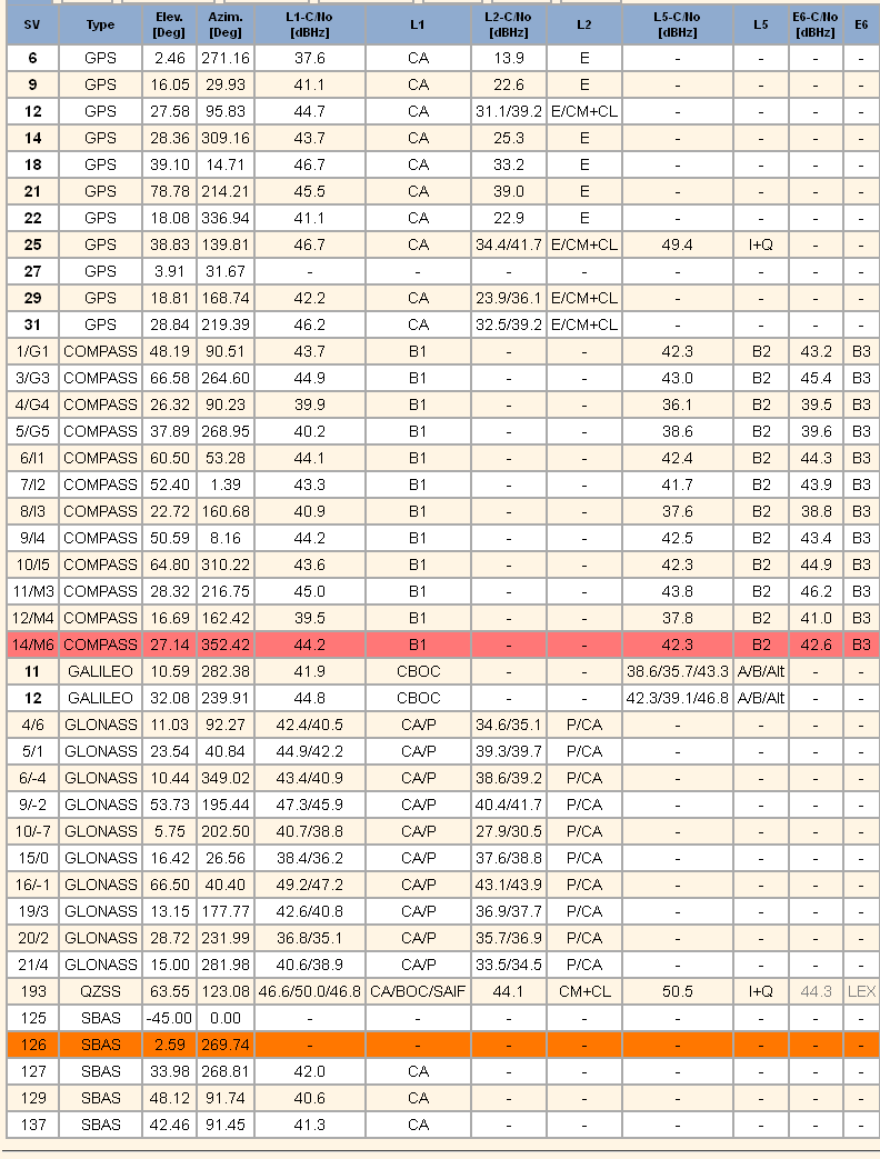
To highlight this point, just glance at the following graphical log file generated by software in the latest Trimble Multi-GNSS PNT receiver. The chart depicts a log file from a receiver located in Singapore. The location is significant only because in that location the receiver is in full view of the Japanese QZSS-1 PNT SV and all its extra U.S. originated PNT signals (L2C & L5) mentioned earlier. This particular Trimble receiver is networked and reports results automatically and continuously to a web page, while receiving GVRS updates and corrections plus other PNT information, such as an updated almanac, over the same network. The question becomes, is it a PNT device with a computer and embedded communications? Or is it a computer with communications and an embedded PNT function? You be the judge. Regardless of which you choose, this is the future of PNT and MUE.
This civil receiver reports 40+ SVs with 169 separate signals in view and usable. This does not count the number of Wi-Fi and/or GVRS signals it is capable of receiving. Meanwhile, a GPS MUE receiver in the same location only observes a total of 10 SVs it can process for a total signal count of 20. However, one of the key points on this log depiction has to do with integrity. Notice the orange and red lines. They indicate that the receiver has labeled these signals as “suspect” and has automatically dropped them from the solution for any of a host of reasons — a failed integrity check, jamming, spoofing, wrong way path, a runaway clock, etc. You name it, and if it is suspicious, the receiver will drop that SV and its signals from its PNT calculations. Built-in integrity.
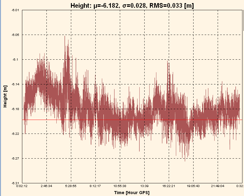
The obvious question becomes just how accurate is this Trimble receiver over a 24-hour period? The next graphical log file denotes that it is accurate within 3 centimeters.
Trimble multi-GNSS receiver web page log file denotes continuous availability of PNT signals with an average accuracy of 3 cms.
Assured PNT
When we asked warfighters what was more important to them in a combat zone — availability or accuracy of the PNT signals, the answer was, not surprisingly, both. But, of course, they need to receive the signal first, and then they can worry about accuracy.
So, if you were Ms. Teri Takai and you were worried about “assured PNT,” would you rather do that with 20 signals from 10 SVs or 169 signals from 49 SVs and some very strong, difficult to jam, terrestrial signals as well — adding up to, on average, 33 times more accuracy than the GPS-only signal? To me, the answer is obvious. And of course, all that is on the line with every mission the DoD performs, as is the safety of our critical national infrastructure as this next chart depicts.
Assured PNT or lack thereof impacts all missions, across all platforms and domains
Assured GPS MUE PNT today depends on:
L1(C/A), L2 P(Y), SAASM (Future M-Code)
Accuracy ~ 1m
Assured Multi-GNSS MUE PNT with all signals available depends on:
GPS L1/L2/L5/L1C/L2C/M-Code/SAASM
SBAS (WAAS, EGNOS, MSAS, GAGAN, SDCM+)
GLONASS L1/L2/L5
Galileo E1/E5 (CBOC & Alt BOC)
Compass B1/B2/B3
QZSS GEO – L1 CA/C/SAIF, L2C, L5, LEX Pilot
Two-way communications, Networking, PNT servers, each PNT device with unique IP address and each PNT device serves as a sensor
Software definable devices
Multiple software applications (Apps)
Accuracy ~ 3 cm
Army Making Strides
I spoke above about DARPA getting into the PNT business, and that is a good thing. But how about the largest military user of PNT, the United States Army? The U.S. Army is making some interesting changes as well. The Army announced a few months ago that there would be no more purchases of DAGRs, and that it was pursuing smartphones as a communications and small computing platform as well as an alternate PNT tool and display device. This is where the Puck comes into play.
While it is a wonderful idea I fully endorse, the problem with the Puck is that under the current design scheme it will still only transmit the current two GPS signals to a smartphone or other PNT display device. And warfighters lament that it is another device run by batteries for which our warfighters need to carry spares. Why not make the Puck a multi-GNSS device? we asked. The answer we received is that it would make it too power hungry and just require more batteries. So to misquote Shakespeare “…for want of a battery, the war was lost?” The Army is definitely on the right track, but they need to figure out how to make the Puck a multi-GNSS device. Can you say Lithium ION and solar charger – Hoorah!?
The Army Hub
The Puck is moving in the right direction. However, with the addition of another device, the Army is definitely on the right track. This device is designated the “Hub,” and while it is again GPS-oriented, it contains multiple terrestrial and internal signal augmentations and backups, as the image depicts.
With apologies to the U.S. Army, I unabashedly modified the chart, and I made it very obvious. The red text depicts my addition of a multi-GNSS card or module versus or in addition to the CGM (Common GPS Module) and GB-GRAM or Ground-Based GPS Receiver Application Module. The multi-GNSS card/module already exists today. Several PNT receiver manufacturers manufacture it with 28-nm technology versus the 95-nm technology — for the as-yet-unavailable for about four more years if the rumors are correct — GPS-only CGM. For me, the addition seems to be an easy fix, as there is lots of room in the Hub. But this fix or module (CGM) is years and millions of dollars down the road, versus a solution that exist today.
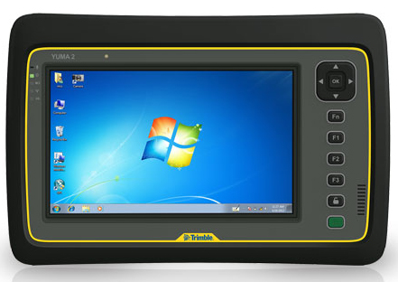
YUMA 2 or Hub or Both
The solution, frankly, is one of the smart tablets available today from numerous manufacturers — seven, actually, that have the wherewithal to produce a secure multi-GNSS device with a SAASM module.
The Trimble Yuma 2.
This is an example of the solution in the form of a Yuma 2 tablet computer from Trimble, which I am in the processing of reviewing for GPS World. The Yuma 2 has all the multi-GNSS features we have been discussing and more, plus it can in time accommodate all the modules scheduled to be incorporated into the Hub. Why build a whole new display device when the core already exists with many more capabilities than were imagined or real estate would ever allow for the Hub? Plus, it is available today as a rugged Mil-Spec device with a full color, high-resolution touch screen. And in the end it will provide a 3-cm solution versus a 1-meter solution. What more could you want? And it is available today with an outstanding and intuitive interface.
Conclusion – Services PNT UE Trends
I have been focusing on the Army today not simply because they are the biggest U.S. military user of PNT devices, but because they are moving in the right direction for the future of PNT and MUE devices. Of course, all the services and many agencies need a well-thought-out and secure PNT solution, and if we have learned anything it is that one size does not fit all. Indeed, our national security and our national infrastructure depend upon future PNT devices. For security purposes alone, they should have a certain degree of application and signal diversity.
Now let’s review:
Army has a way ahead with an assured PNT program.
Includes end of PLGR and DAGR and adding new networkable devices.
Plans for fourth-generation multi-GNSS and multi-function handheld devices and embedded PNT devices as sensors to include the Puck and Hub.
Marine Corps: Decertified PLGRs in 2009 and attempts to limit the use of DAGRs.
DAGRs used primarily as embedded devices.
Purchasing approved SAASM devices from commercial vendors.
USAF: Outfitted 70% of aircraft with modern, integrated, networkable and upgradeable PNT devices.
Navy: More than 60% of the fleet outfitted with modern PNT networked devices.
The Bottom Line is – One size does not fit all but one conclusion is clear – while GPS may and will always hopefully be the Gold Standard – multi-GNSS solutions are the future.
The Future of PNT Devices
This last list depicts the future of PNT as best as I can define it; indeed, as it has already been defined for us by our warfighters and first responders or, as Kirk Lewis would have me say, government users. The users are not waiting around, nor have they bothered to adhere to woefully out-of-date regulations. It is what they desire, and since their lives depend on it, it is what they should have.
Multi-GNSS — Utilize all PNT signals available.
Space and Terrestrial (GPS, GLONASS, eLORAN).
Traditional and non-traditional (Wi-Fi, GVRS, carrier signals).
Multi-function COTS devices with non-proprietary OS (operating System), intuitive interfaces and Mil-Spec ruggedized.
Multiple methods of communications: Wi-Fi, Skype, 4G, text, auto-text, satellite.
Software Downloads – Applications
COTS applications plus .mil apps store.
Networked devices for SA, updates and PNT,
Real-time satellite imagery and mission data injects.
Defense and intelligence LBS.
Each device will be a sensor on a network,
Automatically report jamming, interference and location data.
Utilize SAASM and anti-jam military signals only as required.
Thanks you for your time and kind attention today. And remember, Happy Navigating!
GPS Source, Inc., has released the latest addition to its military product line, a military qualified, in-line GPS amplifier, MA11M.
The MA11M is a military-grade device used to strengthen the signal and reach of GPS. It is designed for GPS conditions where there is a weak signal. This amplifier is designed to work with an external, active antenna, and is primarily for use by military applications (both ground and air) around the world.
“GPS Source realizes the importance of protecting our national assets by designing products that can handle rigorous military environmental demands,” said Robert Horton, CEO of GPS Source. “This amplifier has been qualified for temperature, altitude, explosive atmosphere, humidity, vibration, among many other challenging conditions. The qualifications allow the military to use this device without reservation. Test summaries (MIL-STD-810 and EMI) are available upon request.”
The ruggedized MA11M GPS amplifier is designed with the thin link margins of satellite navigation systems in mind, and is a single-stage gain block that covers the GPS, Galileo, and GLONASS frequencies. The device features 30 dB of gain and excellent gain flatness of less than 1 dB.
Maiden flight trials have been successfully conducted in Moldova using GMV’s magicSBAS solution. These trials form part of a GMV-led European Commission FP7 collaboration project.
In 2011 the European GNSS Agency (GSA) awarded GMV the EEGS2 project (EGNOS Extension to Eastern Europe). The main objective of the project is to demonstrate through flight trials the benefits of the European Geostationary Navigation Overlay Service (EGNOS) in areas of Eastern Europe where it is not yet available, such as Poland, Romania, Ukraine, Moldova and Russia, and to prepare the civil aviation authorities and air navigation service providers for future use of the system.
In the context of this project, after the tests conducted in Spain, the maiden flights have been successfully carried out in Moldova, using the equipment and tools developed by GMV. The Moldova demonstrations have given pilots and service providers a clear idea of the potential benefits of EGNOS and the flying procedures of the near future, GMV said.
Four flights had previously been conducted in Spain in November, December and February. The satisfactory results of these flights then paved the way for the demonstrations in Moldova.
The magicLPVsystem, developed under this project, enables LPV approaches (localizer performance with vertical guidance) to be carried out using the signal generated by the magicSBAS application. This test environment allows any region of the world to analyze the air-navigation benefits to be obtained with deployment of a Space Based Augmentation System (SBAS). This signal is read by Internet and transmitted by radio frequency in the vicinity of the airport, allowing LPV approaches to be made in places where SBAS is either completely unavailable or available only on a very limited basis.
Eight flights in all were carried out in various Moldovan airports, including Chișinău International Airport. Test results were highly satisfactory, demonstrating the simplicity of equipment configuration and operation, and the performance of the magicSBAS signal, GMV said.
“These trials are an important milestone for GMV, for the project and, fundamentally, for the use of EGNOS in the countries of Eastern Europe in the near future,” said Miguel Romay, executive director of GNSS–Aerospace.
GMV will continue with these demonstrations in other countries of Eastern Europe. The next trip in two weeks will be to Romania, where new flights are expected to be just as successful.
iTRAK Corporation, a wireless GPS-based tracking, mapping, and fleet reporting company, has made available its iTRAK Virtual Fleet Support Manager service. This service will allow iTRAK customers to use one or a group of expert iTRAK employees who will help to cost effectively manage many of the functions associated with the iTRAK GPS tracking system and fleet management related logistics. This will free the customer to focus on applying the provided information for better and more efficient use of their fleet, iTRAK said.
This service will provide customers standard or custom reporting, management of alerts and geospatial features such as geofences and landmarks, and monitoring the status of vehicles and tracking devices. The Virtual Fleet Support Manager can also help manage grouping of devices for analysis and supervision by customer associates, reassignment of vehicles, and online review of overspeed and idle alerts, which can help to reduce overall fleet fuel consumption. The professional Virtual Fleet Support Manager (VFSM) team can also help to set up and manage some of the more advanced features of the system, such as maintenance reporting, updates to the cloud-based fleet vehicle or asset database, as well as the online driver database.
Other activities may be requested by iTRAK customers, such as custom tracking, fuel reports, and alerts for maintenance such as oil, tire, and engine maintenance.
Additional reminder alerts such as tag and insurance renewal can also be setup and supported as needed. Regular status reports will be provided to iTRAK VFSM customers; the iTRAK team can also provide additional consulting on how their fleet and tracking technology can be further used to optimize fleet efficiency and reduce overall operation costs.
“Many of the successful fleet based companies we provide services to have reorganized for higher efficiency. As they have subsequently grown many have been lacking the needed bandwidth to oversee or process some of these advanced technical but vital logistical-related activities,” said Craig Gooding, director of sales at iTRAK. “By using our Virtual Fleet Support Manager service, we can help bridge this gap for the customer; while the customer can focus on using the information the system generates in order to help improve their business. They can also be certain that an expert is helping them to use all the features of the system to get the maximum value out of their investment in fleet management information technology. This includes immediate use of new features as soon as they are available.”
An unofficial group of airmen from the United States Air Force (USAF) is climbing the world’s mountains to spread patriotism and pride in the military, and raise funds for military charities. The team has already achieved six of the famed “seven summits” of the world as part of the USAF Seven Summits Challenge. At this moment, they’re pushing toward the final challenge, the summit of Mount Everest.
Taking part is Capt. Colin Merrin, a GPS operator from the 2nd Space Operations Squadron (2SOPS). Merrin and the USAF Seven Summits Team will climb the Southeast Ridge of Mount Everest via the South Col, a route originally pioneered by Sir Edmund Hillary and Tenzing Norgay in 1953.
The seven summits are the highest mountains of each of the seven continents. Climbing all of them is regarded as a top mountaineering achievement.
In the photo above, Merrin is shown standing at Aconcagua base camp in the Andes mountain range in Argentina. His trek up Aconcagua in February 2012 helped prepare him for his Everest climb.
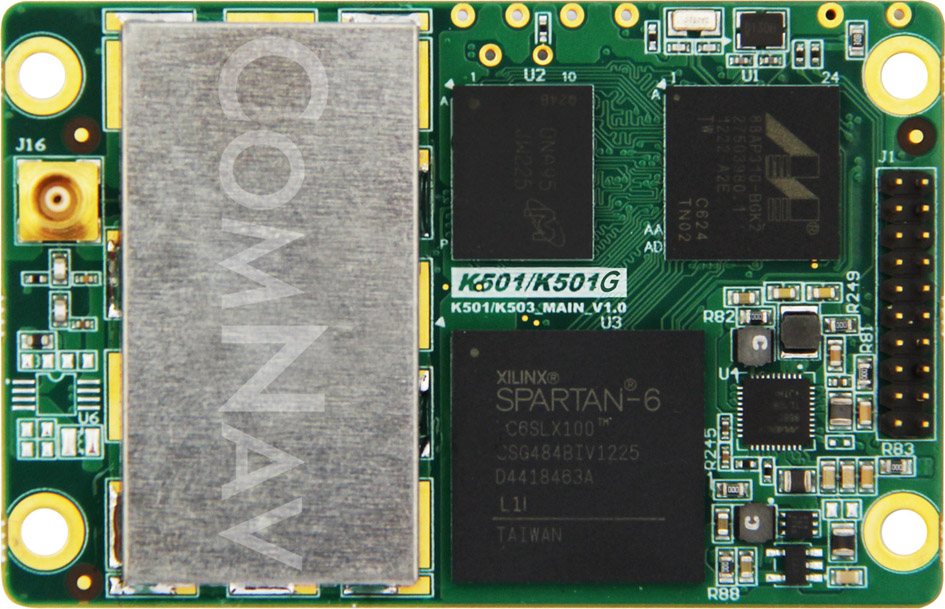
The K501 GNSS OEM board by ComNav is a GPS+BeiDou small-sized OEM board. K501 has advanced dynamic acquisition ability and high-accuracy carrier phase calculating. By using the GPS+BeiDou dual system high-dynamic processing engine, work in difficult environments is easier and RTK positioning accuracy can reach the centimeter level. The hardware size, interface, and data command are compatible with major brand OEM boards.
The K501 GNSS OEM board by ComNav
Features include:
GPS L1/L2+BeiDou B1/B2 dual satellite system calculating
Configurable GPS/BeiDou single-system positioning and GPS+BeiDou dual-system positioning
Compatible with other major brands on physical size, interface and data command
Directly export PJK coordinate
Supports short, middle and long baseline, RTK working distance can reach 50 KM
Easy to customize, can satisfy different kinds of demands
Game Golf, a wearable technology and integrated software platform for golf, is available for pre-0rder, and expected to be released this summer. Backed by professional golfers Graeme McDowell and Lee Westwood, it seamlessly records a player’s golf game to make the game more engaging, visual, interactive, shareable and social, both on and off the course.
“Game Golf not only gives everyone access to crucial data to dramatically improve your golf game and handicap, but it also makes playing more motivating, rewarding, social and fun,” said Graeme McDowell, 2010 U.S. Open Champion and Game Golf investor. “The product is extremely intuitive, doesn’t disrupt your game and is essential for any golfer looking to understand their game better, knock down their handicap, give themselves a competitive edge and compete with their friends and family across the globe.”
Game Golf is designed by fuseproject and Yves Béhar, CEO of fuseproject and Chief Creative Officer at Jawbone, the maker of the wireless Jambox speaker. The Game Golf elegant and discreet wearable device tracks the data around the course, and uploads the data automatically to an intuitive app which allows you to track, analyze and share the data collected. It tracks the most important statistics from your golf game, including club-by-club performance, fairway accuracy, greens in regulation and putting.
“The design of the Game Golf app and product has been closely integrated: a beautiful and dynamic presentation of play data, easy and fun ways to share, non-disruptive hardware and experience,” said Yves Béhar, CEO of fuseproject. “The design and user interface is crafted to deliver a 21st-century experience of the game.”
The product uses a combination of positional technology, motion sensors and near field communication to capture the golfer’s data from the course. The device is engineered to be power efficient and extend battery life beyond that of the average smartphone and provides two full rounds of tracking on one charge. Data from the device is synced to the cloud via Bluetooth to a smartphone or via USB to a PC.
“The golf community has been calling out for a product that tracks their game effortlessly, shares results with friends and provides intuitive data with which they can analyze to constantly improve their game — and Game Golf is here to provide that,” said John McGuire, CEO and Co-Founder, Game. “A new era of quantification and gamification is rapidly and radically changing the way we live, work and play. Existing golf technologies only provide technology that helps on the course, but we provide the complete package, giving you everything you need to improve your game and compete before, during and after you take to the course.”
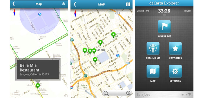
deCarta, Inc., an independent LBS technology company, has introduced its Xplorer V8 navigation platform, combining deCarta’s cloud-based navigation service with customizable client-side libraries. This combination gives application developers the ability to quickly add vector mapping and turn-by-turn navigation to any mobile application, from local search to fleet management, providing users with fast, accurate driving directions to a destination or search result.
Xplorer V8 is available as a white label application or as client-side libraries depending on the degree of customization required. deCarta’s L2 advanced local search technology is fully integrated into the platform to help users find destination addresses or local points of interest (POI).
deCarta navigation technology powers products such as GM OnStar, Ford Sync, INRIX, Appello, TCS and MotionX GPS Drive. With Xplorer V8, deCarta lets developers tightly integrate that functionality into their own applications or to build custom navigation applications. Examples of the use of Xplorer V8 include:
Local search applications that offer route guidance to the search destination from a mobile phone or tablet.
Branded navigation applications for global automotive companies.
Mobile applications that display places of interest in a vector map display with smooth panning, rotation and zooming.
Fleet management solutions that offer route guidance and tracking to ensure that drivers are directed efficiently to their destinations.
deCarta has already engaged with customers in each of these areas and expects to be announcing new partners for Xplorer V8 in the coming months.
The Xplorer V8 platform consists of a cloud-based service and a set of core client-side libraries that work together to provide a high-quality navigation experience.
The Xplorer V8 Navigation Cloud Services provide local search and navigation response based on deCarta’s geospatial technologies. deCarta hosts these services in global data centers in Santa Clara, London, Seoul, Beijing and Sydney.
The Xplorer V8 CoreLibraries are integrated into client side applications. They support three critical functions that can be used together as a group or individually as needed by the customer.
Local Search: Single line search and geocoding based on deCarta’s L2 technology.
Guidance and Routing: Voice guided navigation, displayable as an overview, a list of directions or in turn-by-turn sequence.
Map Display: Vector-based maps that support turn-by-turn navigation, voice guidance, 3D display, immediate off route determination and rerouting.
Xplorer V8 libraries are compatible with all Android-based platforms for mobile devices, tablets and automotive embedded systems. Apple iOS versions will be available at the end of June.
For companies interested in a turn-key navigation solution, Xplorer V8 is also available as a white-label navigation application that can be branded to match the customer’s needs.
“Industrial-grade navigation engines are extremely hard to develop. To meet the demanding consumer expectations, they have to perform well, with speed and accuracy across a wide range of circumstances,” said J. Kim Fennell, CEO of deCarta. “Xplorer V8 packages all of deCarta’s navigation experience and makes it available for application developers to integrate directly into their apps.”
Xplorer V8 is available immediately for deployment in North America and Australia, with Western Europe coverage coming in June. Other countries will be included in the following months.
Raytheon Company has completed delivery of more than 200 Paveway GBU-50 guidance kits to a European partner.
The GBU-50 provides the 2,000-pound MK-84 or the BLU-109 penetrator with all-weather GPS navigation combined with precision terminal laser guidance. A full range of selectable terminal impact angles combined with a mature combat-proven, height-of-burst maximizes the capabilities of both the MK-84 and BLU-109.
“This delivery is a significant milestone for the Enhanced Paveway II program as it provides unique capabilities to our allies,” said Harry Schulte, vice president of Raytheon Missile Systems’ Air Warfare Systems. “As we begin our second production run of the GBU-50, we have substantial interest from the international community.”
Each Enhanced Paveway II guidance and control section is compatible with warheads ranging from the 250-pound MK-81 to the 2,000-pound MK-84 along with the BLU-109. There is no need for the warfighter to acquire a different guidance and control section for different warhead use.
According to Raytheon, the Paveway family of laser-guided and GPS and laser-guided bombs, has revolutionized tactical air-to-ground warfare by converting “dumb” bombs into precision-guided munitions. Paveway laser-guided bomb kits comprised more than half the air-to-ground precision-guided weapons used in Operation Iraqi Freedom, Enduring Freedom and Unified Protector.
Telit Wireless Solutions, provider of high-quality machine-to-machine (M2M) modules, services and solutions, has announced approval by Sprint for its CE910-DUAL cellular M2M module. A dual-band CDMA 1xRTT module, the CE910-DUAL allows Sprint M2M Solutions customers to deploy a wide range of M2M applications benefiting from reliable connectivity over Sprint’s nationwide network while enabling cost-sensitive business plans.
The CE910-DUAL packs high value features in its ultra-compact 28.2 x 28.2 x 2.04 mm Land Grid Array (LGA) package. USB 2.0 full-speed support and a rich set of drivers make it ideal for embedded applications requiring easy integration to platforms based on the latest desktop and mobile operating systems such as Windows and Linux. Full-duplex data rate of 153.6 Kpbs and extended operating temperature range of -30°C to +85°C make it a suitable platform for mobile and fixed applications such as vending, point-of-sale (POS), tracking, smart metering, and telematics devices.
“Sprint plans to maintain our CDMA 1xRTT network capability for the long term as part of our overall Network Vision strategy,” said Wayne Ward, vice president, M2M Group, Sprint. “We have been working with Telit for several years as a Sprint preferred provider and one of the leading module suppliers to the M2M industry and believe their xE910 form factor makes it easy for customers to deploy on either the EV-DO or 1xRTT CDMA Sprint networks.”
“With this approval, the cost-effectiveness, reliability and functionality of the CE910-DUAL module are accessible to Sprint M2M and Telit customers along with outstanding support and network connectivity from one of the nation’s top-rated cellular networks,” said Mike Ueland, senior vice president and general manager of Telit Wireless Solutions North America.
Part of the xE910 form factor family, the CE910-DUAL protects investments by offering complete compatibility with the DE910-DUAL, a Sprint-approved companion product for EV-DO Rev. A applications.
u-blox, provider of wireless and positioning semiconductors, software and solutions, announces that its LISA-U200 and LISA-230 6-band UMTS/HSPA+ module series as well as LISA-U270 dual band module has achieved Certified M2M Hardware status by Vodafone, the world’s second largest mobile telecom company. Vodafone owns and operates networks in more than 30 countries and has partner networks in over 40 additional countries.
The certification allows global customers to design LISA-U2 modems into M2M devices operating over Vodafone’s extensive 3G network in Europe, Asia, Africa, Australasia and the Americas. Main applications include vehicle and asset tracking, industrial automation, metering, and security devices.
The LISA-U2 series is a multi-band 3G module series in LCC package delivering high data-rates (5.76 Mb/s uplink and up to 21.1 Mb/s downlink) with voice and data capabilities. They are compatible with consumer, automotive and industrial applications. For telematics applications such as fleet and asset management, the module provides easy integration with u-blox GPS, GLONASS and QZSS receivers. The modules are compatible with all UMTS bands used worldwide.