Category: Applications

  • Polaris Wireless Closes Recapitalization Round

    Polaris Wireless, a high-accuracy, software-based wireless location solution company based in Mountain View, California, today announced that the company closed on a recapitalization of existing equity interests on April 25, 2013. As part of the recapitalization, Polaris Wireless completed a Series C financing with $10 million from Industry Ventures, a leading investment firm focused on the venture capital market, and Industry Ventures Managing Director Victor Hwang has joined the Polaris Wireless Board of Directors.

    “Industry Ventures seeks to invest in market leading growth companies and we believe Polaris Wireless is a clear leader in the wireless location market,” said Hwang. “We are very excited about Polaris Wireless’ strong growth trajectory and global presence, and look forward to working with Manlio Allegra and the senior team at Polaris Wireless in their next chapter of growth.”

    The investment by Industry Ventures also returned capital to Series A investor Draper Fisher Jurvetson (DFJ) and will also be used to fund Polaris Wireless’ future international growth.

    “We look forward to an exciting new growth chapter for our company with Industry Ventures by our side,” said Manlio Allegra, Polaris Wireless CEO and Co-founder.

    Polaris Wireles experienced a record increase in revenue and profitability in 2011 and 2012, driven by aggressive growth for its location solutions across the globe. Twenty-four U.S. wireless carriers, six managed services partners, and 15 international deployments now rely on Polaris Wireless location solutions to enable emergency call applications, lawful and mass location surveillance, and other location-based services.

  • TomTom Redesigns GPS Sport Watch

    TomTom Redesigns GPS Sport Watch

    TomTomWatches

    This summer, TomTom will make available a new range of GPS watches to deliver at-a-glance performance information for runners, cyclists and swimmers. The ultra-slim TomTom Runner and TomTom Multi-Sport GPS sport watches feature an extra-large display, full-screen graphical training tools, and one-button control to make it easier for users to access the information needed to stay motivated and achieve their goals.

    “We know that most GPS watches on the market are too bulky and complicated to use while training,” said Corinne Vigreux, managing director, TomTom Consumer. “Just as we developed easy-to-use navigation products that changed the way that people move from A to B, we have developed a range of ultra-slim GPS sport watches that are far more comfortable to wear and far easier to use. Runners and multi-sport athletes can now view their performance information at-a-glance, making it easier to achieve their fitness goals.”

    The new TomTom watches feature an extra-large, high-resolution and high-contrast display that makes it easy for runners and multi-sport enthusiasts to quickly see their distance, time and pace while they workout even in bright sunshine, TomTom said.

    The new watches feature TomTom’s Graphical Training Partner. Easy-to-read full-screen graphics help users get the most out of their workouts. They can view their real-time performance at-a-glance with three graphical training modes:

    Race: Race against a personal best or most recent run. Quickly track performance with real-time graphics, to continue to improve run-after-run.
    Goal: Set a distance, time or calorie goal and see progress toward that goal with simple, full-screen graphics and alerts.
    Zone: Set a target for pace or heart-rate (with optional heart-rate monitor) and track progress in a simple full-screen graph throughout a workout.

    The new TomTom range includes an intuitive one-button control that enables users to easily navigate up-down-left-right through menus to access key stats and watch features, the company said. Unlike the majority of existing GPS watches on the market that feature multiple small and hard-to-operate buttons, the one-button control is easy to operate while moving and can be easily controlled in all weather conditions and while wearing gloves.

    In addition to their ability to deliver at-a-glance performance information, the TomTom Runner and TomTom Multi-Sport include advanced features designed to address the needs of runners and multi-sport enthusiasts alike:

    Ultra-slim design: At just 11.5mm, the slim design of the watch module comfortably fits men and women, and all wrist sizes.
    Indoor tracker: Accurately track indoor runs using built-in sensors to count strides, so that users can monitor pace and distance even while running on a treadmill.
    QuickGPSFix: Get started faster by using the latest in GPS and GLONASS satellite technology to quickly find their precise location.
    Multi-platform compatibility: Sync, analyze and share stats on popular running sites and community platforms, including the TomTom MySports website, MapMyFitness, RunKeeper, TrainingPeaks and MyFitnessPal.
    Super-tough display: Scratch- and impact-resistant glass stays easy-to-read, workout after workout.
    Weather- and waterproof: Waterproof up to 50 meters/5ATM.
    Long-lasting battery: Up to 10-hour battery life (GPS mode).
    Bluetooth smart: Connect to sensors using the latest wireless technology.
    Heart rate monitor: Use the Bluetooth Smart Heart Rate Monitor to track training zone for weight control, performance or speed.

    TomTom Multi-Sport includes all the features included in TomTom Runner, and also allows multi-sport athletes to track their distance, time, speed and other key metrics when they cycle or swim. The TomTom Multi-Sport is also enhanced with the following features and options:

    Dedicated bike mount: Easily see key stats at-a-glance with the specially designed bike mount.
    Cadence sensor: Track cadence, speed and distance, indoors and out.
    Built-in altimeter: Accurately track elevation, ascent, descent and grade with the built-in barometric altimeter.
    Swimming motion sensor: Check detailed swim metrics such as laps, strokes, time and speed, and calculate a SWOLF score to show swim efficiency.

    The TomTom Runner and TomTom Multi-Sport will be available in Summer 2013.

  • GPSTrackIt Adds Features to Fleet Manager System

    Two new features have been added to GPSTrackIt’s Fleet Manager vehicle tracking system. Route Optimization evaluates the stops in a route and rearranges them to produce the most efficient ordering of the stops. In addition, fleet managers and dispatchers can now compare a route with the actual vehicle trail recorded by the system.

    “Route Optimization has several benefits,” according to Eddie Bermudez, GPSTrackIt’s product manager. “It streamlines the route, which means less time is spent driving around. That saves fuel, which helps you run a greener fleet. It also saves money and improves customer service. Optimizing a route may allow for additional stops to be added.”

    While optimizing a route on the system is one thing, it’s another whether the driver actually drove the route assigned. Fleet Manager’s Vehicle Trails feature can map out Ignition On/Off, Travel Start/Stop, and Drive events for a set date and period. The software has been modified with a route selection list and a button that displays the route superimposed over the vehicle trail.

    “This enables a dispatcher or fleet manager to compare a driver’s plotted route to their vehicle trail,” Bermudez added. “Managers can determine whether drivers are making unscheduled or unauthorized stops.”

    For more information about GPSTrackIt, their new features, or their Fleet Manager vehicle tracking system, visit the website.

  • GPS Block IIF-4 Launch Set for Today

    GPS Block IIF-4 Launch Set for Today

    News courtesy of CANSPACE Listerv.

    Update: The launch window for the liftoff has been adjusted slightly to  21:38-21:56 UTC.

    The United Launch Alliance (ULA) Atlas 5 rocket’s rollout to the pad  took place Tuesday. Weather forecasters have predicted an 80
    percent chance of favorable conditions for launch.

    Updates on the mission and live video coverage of the launch is available.

    Live video will also be available here and on this satellite feed (for those of you still with backyard dishes): SES 2, Transp. 21, C-band, 87° West

    ULA is also posting to Facebook and tweeting to Twitter at twitter.com/ulalaunch; look for the #GPSIIF-4 hashtag.


    The next GPS satellite launch is scheduled for May 15 with the launch window extending from 21:39 to 21:58 UTC. An Atlas 5 rocket will be used to place the satellite, GPS IIF-4, into orbit from Cape Canaveral Air Force Station.

    This is the first time in almost 28 years that an Atlas rocket will be used to launch a GPS satellite. All of the prototype or Block I satellites were orbited with Atlas rockets. Since then, Delta rockets have been used exclusively for GPS launches. The IIF satellites are being launched with a mixture of Atlas and Delta rockets.

    The IIF-4 satellite, also known as SVN66, will operate as PRN27. SVN66/PRN27 will eventually occupy the C-2 slot, replacing SVN33/PRN03, a Block IIA satellite launched in 1996. Reportedly, SVN66/PRN27 will go through an extended period of testing following launch, and is not expected to be set healthy until August. SVN33 will become a reserve or backup satellite.

    Ground Stations: ER = Eastern Range; BOSS = Call sign of New Hampshire   Station, New Boston Air Force Station, New Hampshire; LION = call sign   of Telemetry & Command Station, Royal Air Force Oakhanger, Hampshire,   U.K.; Diego Garcia = Diego Garcia Station (call sign REEF), British   Indian Ocean Territory; Guam = Guam Tracking Station (call sign GUAM),   Dededo, Guam. TDRS: Tracking and Data Relay Satellite MES1: Centaur first main engine start MECO1: Centaur first main engine cutoff MES2: Centaur second main engine start MECO2: Centaur second main engine cutoff At spacecraft separation, the GPS satellite's orbit will be circular   with a height of 11,047 nautical miles or 20,459 kilometers and an   inclination of 55 degrees.
    Ground Stations: ER = Eastern Range; BOSS = Call sign of New Hampshire Station, New Boston Air Force Station, New Hampshire; LION = call sign of Telemetry & Command Station, Royal Air Force Oakhanger, Hampshire, U.K.; Diego Garcia = Diego Garcia Station (call sign REEF), British Indian Ocean Territory; Guam = Guam Tracking Station (call sign GUAM), Dededo, Guam.
    TDRS: Tracking and Data Relay Satellite
    MES1: Centaur first main engine start
    MECO1: Centaur first main engine cutoff
    MES2: Centaur second main engine start
    MECO2: Centaur second main engine cutoff
    At spacecraft separation, the GPS satellite’s orbit will be circular with a height of 11,047 nautical miles or 20,459 kilometers and an inclination of 55 degrees.
    (Courtesy of SpaceFlight Now) This is the 45th Launch Support Squadron crew patch for the GPS 2F-4   mission, which is Boeing's Space Vehicle (SV) #5. Each SV is a named   for a navigation star and its constellation. SV-5 is named Vega, with   constellation Lyra. On the patch, they are the large star and   constellation in the background of space. The United Launch Alliance   Atlas 5 rocket is shown lifting the satellite from the Eastern Launch   Site at Cape Canaveral Air Force Station. The Squadron mascot is a   gator, and a lyra is a Greek harp. SSgt Thomas Hogan drew a   "Toga-Gator" and Lt Ken Stuart did the patch design.
    (Courtesy of SpaceFlight Now) This is the 45th Launch Support Squadron crew patch for the GPS 2F-4 mission, which is Boeing’s Space Vehicle (SV) #5. Each SV is a named for a navigation star and its constellation. SV-5 is named Vega, with constellation Lyra. On the patch, they are the large star and constellation in the background of space. The United Launch Alliance Atlas 5 rocket is shown lifting the satellite from the Eastern Launch Site at Cape Canaveral Air Force Station. The Squadron mascot is a gator, and a lyra is a Greek harp. SSgt Thomas Hogan drew a “Toga-Gator” and Lt Ken Stuart did the patch design.


  • OpenStreetMap Launches Enhanced Map Editor

    OpenStreetMap, the user-created map used by many of the biggest sites on the web, has today unveiled an entirely new editor that makes it easier to contribute than ever before.

    According to the announcement, the new editor, codenamed ‘iD’, boasts an intuitive interface and clear walk-throughs that make editing much easier for new mappers. By lowering the barrier to contributions, we believe that more people can contribute their local knowledge to the map – the crucial factor that sets OSM apart from closed-source commercial maps.

    OSM_id_animated

    To accompany the expected growth in OSM’s contributor base, the OpenStreetMap Foundation is launching an appeal to fund new hardware for the project. The appeal aims to make the editing experience more resilient, so that the OSM community can continue producing the most extensive and up-to-date map of the world. You can donate online at donate.openstreetmap.org.

    “OpenStreetMap’s growth in the past two years has been phenomenal,” explained Simon Poole, chairman of the OSM Foundation. “We’ve seen an explosion in the amount of local knowledge our mappers contribute to the map. This has encouraged more and more big-name websites and apps to switch to OpenStreetMap, while also enabling map hackers and geo enthusiasts the world over to build startling, imaginative visualisations from our open data.”

    “Now, with the new editor and our plans for new hardware, we’re stepping up another level to make OpenStreetMap, not Google, the default choice for mapping and map data.”

    OpenStreetMap reports that the new iD editor is a pure HTML5 experience, using the cutting-edge D3 visualisation library. Behind the clear design and intuitive interface is a sophisticated back-end that automatically recommends the most popular ‘tagging’ conventions used by the OSM community.

    According to the announcement, development began as a community project in July 2012, and has since been taken forward thanks to a $575,000 grant from the Knight Foundation, with development being co-ordinated by MapBox – one of several companies which offer commercial services on OpenStreetMap’s open data.

    From later today, new OpenStreetMap reports that users with a modern browser will automatically use the new iD editor. Users can switch between this and the existing Flash-based Potlatch 2 editor (which is being refocused as a tool for intermediate users) using their settings page or the drop-down ‘Edit’ menu. Advanced desktop-based editors are also available.

    The editor software is entirely open source, with code available on github under an ultra-permissive licence.

  • TomTom Redesigns PNDs, Introduces NavKit Engine

    TomTom Redesigns PNDs, Introduces NavKit Engine

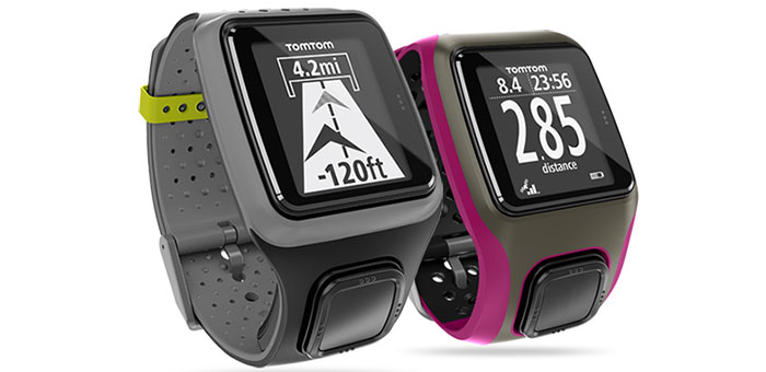
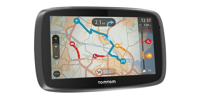
    TomTom has redesigned its personal navigation devices with new TomTom GO. The TomTom GO has new interactive map, lifetime TomTom Traffic and 3D maps that give drivers the ability to know precisely what is going on around them, as well as what lies up ahead, TomTom said.

    TomTom has also launched its new navigation engine, NavKit.

    “Where navigation used to be about getting people to unfamiliar destinations, we are now empowering drivers with easy access to the information they need to make the smartest driving decisions, every day,” said Corinne Vigreux, managing director of TomTom Consumer. “We have completely redesigned the PND to become an essential daily driving tool. By providing easy access to our world class TomTom Traffic and enabling drivers to see more than just the road ahead, drivers will feel on top of their journey like never before.”

    Drivers can easily access the travel information they need via a high-resolution, capacitive touchscreen, TomTom said. A new Interactive Map responds and scales to touch. Drivers can  zoom in and out to find and explore places on the map with their fingertips and tap on the map to get an instant route to a destination.

    New NavKit Engine

    TomTom’s navigation engine, NavKit, will power all future TomTom navigation products and be available for licensing to automotive and enterprise customers. The configurable component architecture has been designed to enable rapid integration. NavKit has programming interfaces for adding a customised user interface, porting to any operating system and integrating navigation services. As a result, the development of a connected navigation system on any device platform becomes far quicker and simpler, TomTom said.

    The new NavKit engine incorporates all the navigation logic of an on-board turn-by-turn navigation application. Every element has been enhanced to deliver an improved user experience including route planning, free text search, 2D map browsing and 3D guidance view, map-matched positioning and real-time guidance, TomTom said.

    “The automotive industry’s next challenge is to create a seamless connected car experience,” said Harold Goddijn, CEO at TomTom. “To help our customers achieve this, we created NavKit, a flexible, future-proof navigation platform. NavKit makes the creation of connected navigation solutions easier and faster than ever before.”

    NavKit’s architecture will allow customers and industry partners to replace components in a modular way. Its new routing engine achieves faster and more accurate dynamic routing, both on TomTom’s maps and on Navigation Data Standard (NDS) maps. Additionally, it provides better routes around traffic and fully supports TomTom Traffic, Version 6.0, including incident duration predictions and jam tail warnings. The new free text search engine provides easier and faster address and POI search. A new map visualization engine greatly improves 2D map browsing and introduces a 3D guidance view.

    TomTom GO Features

    The new TomTom GO series also comes with Lifetime TomTom Traffic. TomTom’s world-class traffic information pinpoints exactly where delays start and end, helping drivers to get to their destinations faster. Drivers can choose to connect to TomTom Traffic in one of two ways, either via Smartphone Connected or Always Connected. Smartphone Connected devices are ready to receive TomTom Traffic by connecting to a smartphone via Bluetooth. Smartphone Connected uses an existing smartphone data plan to access TomTom Traffic, as well as other services like TomTom Speed Cameras.

    Always Connected devices offer the simplest way to receive TomTom Traffic straight out of the box, TomTom said. With connectivity built-in and with no additional costs for roaming, drivers can access TomTom Traffic and other services, including TomTom Speed Cameras.

    3D Maps bring buildings and landmarks to life so that drivers always know exactly where they are.

    The new TomTom GO range has a simplified product line-up. Customers can select their preferred screen size, choosing from a 4.3″, 5″ or 6″ model; then decide how they prefer to receive their TomTom Traffic information, either via Smartphone Connected or Always Connected.

    Additional TomTom GO Features

    Route Bar: Essential traffic and travel information at a glance. The Route Bar shows precise traffic and speed camera information on the road ahead.

    Quick Search: Drivers can find their destination faster with intuitive search results. Quick Search starts finding destinations as soon as the driver starts typing.

    My Places: Drivers can see their favourite locations on the map and personalise their map with My Places. This makes it easier to find and navigate to favourite locations again and again.

    Lifetime Maps: Always drive with the latest map. For the life of the product, drivers can download four or more full updates of the map onto the device, every year. Drivers receive all updates to the road network, addresses and Points of Interest.

    Speed Cameras (three month trial): Drivers can drive in a more relaxed way, receiving alerts for speed cameras ahead. These timely warnings increase drivers’ awareness of local speed limits and help to save money on speeding fines. As part of TomTom’s global driving community, drivers will benefit from an advanced and highly accurate warning service.

  • PayGo’s Auto Insurance Solution to Be Based on Telit GSM/GPRS Tech

    Telit Wireless Solutions and PayGo Systems, an Israel-based telematics service provider (TSP) have announced that PayGo’s new TTM Type B family of PAYD solutions will include Telit’s ultra-compact GSM/GPRS cellular module, the GE865-QUAD. The solutions include self-contained consumer installable data collection devices for high-growth application area — UBI/PAYD — in the automotive insurance industry. PayGo and Telit plan to expand connected automotive data collectors into new and existing markets made possible by PayGo’s self-powered product concept.

    The TTM Type B is a self-powered peel-and-place product family with a multi-year internal battery power source. Smart energy consumption algorithms in conjunction with Telit’s energy efficient GE865-QUAD module, which is fully certified by mobile network operators worldwide, allow PayGo to deploy the TTM Type B family in any regional market its customers offer auto insurance, Telit said.

    The TTM Type B family incorporates a feature set designed to address specific insurance industry application requirements beyond basic UBI including distance traveled, minutes of use, trip start and end time and geo-zones where vehicle was driven in a continuous data collection stream. It is also able to notify appropriate service centers in real time about crashes and crash location, and to provide trip summaries (time, distance, etc.) via text message for each trip as well as curfew violations (time and geo-zone). The PayGo device is packaged in a cellphone-size enclosure requiring no external wires and  is ready to be affixed, out of the box, to the inside of the car’s windshield like a traditional toll-pass module. The unit is self-powered and completely independent of any vehicle system, including power. To meet requirements from the insurance industry, the TTM Type B senses and reports installation of the device as well as tampering or post-installation removal. The products are fully FCC and CE certified.

    The GE865-QUAD isfor embedded cellular applications where small size and energy efficiency are crucial. Measuring 22 x 22 x 3 miilimeters, the GE865-QUAD is significantly smaller than most cellular modules in the industry. It features an optimized power consumption profile with very low standby current compared to the majority of current competing products. Because of its extremely compact form factor and a rich set of features, including an on-board Python interpreter, it is well positioned for vertical application areas such as telemetry, mobile asset tracking telematics and telemedicine.

  • Smartphone App Locates Injured Farmers in the Field

    Tractor rollovers are the leading cause of death among farmers and claim about 250 lives each year, according to the National Institute of Occupational Safety and Health (NIOSH). These accidents are deadly because they often occur far away from farmers’ homes or roads and they may be unable to reach a phone to call for help. Now, University of Missouri researchers have developed an application for smartphones that uses GPS systems to locate farmers who have rolled their tractors.

    The app, called VRPETERS (Vehicle Rollover Prevention Education Training Emergency Reporting System), uses sensors and GPS capability built into smartphones that can detect rollovers. Once the app detects a rollover, it sends an automatic emergency e-mail and phone message with the coordinates of the accident location to family or emergency responders.

    “The tractor is the main power source for field operations, and tractor rollover accidents have been killing people since the beginning of their use in agricultural production,” said Bulent Koc, assistant professor of agricultural systems management at MU and developer of the app. “More and more farmers are using their smartphones to monitor weather or calculate production inputs while operating machinery. Since they already have their phones with them, installing VRPETERS could help save lives.”

    Data from the NIOSH show that one out of every 10 tractor operators will roll a tractor at least once. NIOSH also notes that only half of the 4.7 million tractors on U.S. farms have rollover protection. In order to minimize false alarm rollovers on the app, Koc and his research assistant Bo Liu designed a device that must be attached to the tractor. This device helps calculate the stability characteristics of the tractor and will provide a warning to the driver when the tractor approaches its rollover point.

    “Many farmers think they can jump out of their tractors in the event of a rollover, but this isn’t the case usually,” Koc said. “Side rollovers can occur in just three-quarters of a second and most people need a second or more to react to an event. So, VRPETERS can benefit farmers when a rollover occurs because they often can’t reach their phones to make an emergency call.”

    VRPETERS can benefit more than just farmers, as the app also can be used on construction vehicles, trucks, snowmobiles, military vehicles, riding lawnmowers and all-terrain vehicles.

    In addition to the rollover device installed on tractors and other dangerous equipment, Koc and Liu designed another device that can be used with VRPETERS. This device can be installed on vehicles and can be used as a backup to stream data to a smartphone or tablet. “With this additional device, parents or fleet managers can obtain real time data on how machines are being used,” Koc said. “If the device detects improper operation, an intervention can occur before an accident happens.”

    Initial testing of VRPETERS was done using a remote-controlled model tractor. Once fully tested on a standard tractor, Koc and Liu will look for an industry partner to market the app.

  • Sprint Selects u-blox for Long-Term CDMA Network Support

    Sprint and u-blox have expanded their collaboration in support of Sprint’s commitment to the 2G (1xRTT) CDMA network. As a carrier committed to network choice, Sprint believes M2M customers should be able to choose or combine 2G, 3G and 4G LTE capabilities, depending on their particular requirements, u-blox said.

    Sprint expects to maintain its 2G network capability for the long term as part of its overall network vision strategy. Both companies believe 2G remains an important network option for business customers, including those that deploy machine-to-machine (M2M) solutions as part of their service or product offerings.

    This collaboration will allow business customers to extend the product lifetime of their existing 2G M2M devices by seamlessly migrating to the CDMA network with minimal effort. Those customers concerned about the continued availability of 2G GSM networks in the U.S., can now select from a variety of affordable u-blox modems tested for compatibility on Sprint’s CDMA 1xRTT network. The u‑blox FW75-C200 modem, a pin-compatible replacement for widely used GSM modem MC75i and its variants, is well suited to continue on 2G without having to migrate to much more expensive 3G and 4G modems.

    “Now is the opportune time for any customers migrating off GSM or designing new products for telematics, telemetry, automotive, and security applications to take advantage of Sprint’s 2G platform,” said Wayne Ward, vice president, M2M Group, Sprint. “Sprint’s network vision strategy enables ongoing 2G connectivity with the security and performance advantages of CDMA, while also supporting a smooth path to CDMA 3G and LTE 4G for customers who choose that transition. We are pleased to collaborate with u-blox to bring these options to 2G-embedded M2M customers.”

    Sprint’s network vision supports network choice for our customers nationwide. As with 3G, Sprint Network Vision is expected to improve Sprint 2G coverage, capacity, and reliability. M2M and other emerging solutions can involve widely varying data transmission speeds. Sprint expects to be able to provide all these network platforms for the long haul as part of a continuing portfolio of technology options.

    “We are proud to have been selected as the preferred provider by Sprint. It will allow customers to leverage Sprint’s impressive CDMA coverage in the US. Forced migration from 2G GSM to HSPA can now be avoided, given Sprint’s commitment to 2G longevity of the CDMA network,” said Nikolaos Papadopoulos, president of u-blox America. “Should customers still want to offer their devices in 2G and 3G, we at u-blox have already prepared for this parallel track with our nested-design module philosophy for 2G/3G platforms, where customers can select the inexpensive CDMA SMT modem LISA-C200.”

    u-blox CDMA module series consists of the FW75 CDMA 1xRTT module in an industry-standard package, as well as the LISA and PCI-express form factors. In addition to technical support, reference designs, evaluation kits, firmware and free module samples, Sprint and u-blox will soon announce nationwide hands-on seminars focusing on GSM to CDMA modem migration.

  • NovAtel SPAN-CPT Receiver Supports OEM6 GNSS Platform

    NovAtel’s single-box SPAN-CPT GNSS/INS receiver now supports the company’s next-generation OEM6 GNSS technology platform. The OEM6 GNSS engine significantly improves positioning performance through its support of GPS and GLONASS, all-in-view satellite tracking and intelligent measurement selection, the company said.

    “We kept the design of the enhanced SPAN-CPT identical to our legacy product to ensure a seamless upgrade process for our customers who would like to take advantage of the improved positioning capabilities,” said Jason Hamilton, NovAtel director of marketing. “The enhanced SPAN-CPT is fully backwards compatible with the previous generation of product. It retains the same compact form factor with identical pin-out and log structure.”

    As with the previous generation product, the upgraded SPAN-CPT integrates NovAtel’s precision receiver technology with fiber optic gyro and MEMS accelerometer inertial components from KVH Industries in one compact unit. The tight-coupling of the GNSS and INS technologies optimizes the raw GNSS and IMU data, delivering a superior position, velocity and attitude solution, NovAtel said. Comprised entirely of commercial components, the SPAN-CPT minimizes the operational complexities of working across international boundaries.

    Production of the OEM6 supported SPAN-CPT begins June 1.

  • Surveyors Invited to ‘Survey Earth in a Day’

    sealOn the day of the solstice, June 21, geospatial professionals around the world and members of Land Surveyors United (a global support network for land surveyors) will be simultaneously recording survey grade GPS data from thousands of points around the globe, in order to gain a more accurate understanding of the earth’s surface.

    This will be the second Survey Earth in a Day event; in 2012 the first Survey Earth event was held, establishing many new understandings between geospatial and geomatics professionals and the general public on geospatial issues, organizers said. “With a mission not only to learn more about the Earth’s surface but also monitor its changes over time, and the changes in public perspective, as a global community, we may be more capable of assessing our future,” organizers said.

    “Our results will change the knowledge we currently have of the shape of the earth and thus provide new information about our planet’s surface for the benefit of all man-kind. Help the surveying industry and the surveyors in your region of the world by representing your area as we re-measure the entire globe in one single day,” organizers said.

    “If you are a geospatial professional with access to survey grade GPS equipment, you should consider helping us set a world’s record, right from where you live and work. Only a surveyor can provide the kind of precision that will be needed to truly understand the shape of planet earth. Just imagine how much this can help our industry,” organizers said.

  • Advanced Navigation Releases Dual-Antenna GNSS/INS

    Advanced Navigation Releases Dual-Antenna GNSS/INS

    Advanced Navigation has released Spatial Dual, its new dual-antenna GNSS/INS. Spatial Dual is a ruggedized miniature GPS-aided inertial navigation system and AHRS that provides accurate position, velocity, acceleration and orientation under demanding conditions. It combines temperature calibrated accelerometers, gyroscopes, magnetometers and a pressure sensor with a dual-antenna RTK GNSS receiver. These are coupled in a sophisticated fusion algorithm to deliver accurate and reliable navigation and orientation, the company said.

    Spatial Dual contains the Trimble BD982 GNSS receiver, which is a triple frequency dual-antenna RTK GNSS receiver. Using dual-frequency moving baseline RTK, Spatial Dual is able to provide heading accuracy of less than 0.1 degrees using its dual antennas. The dual-antenna heading works while both stationary and moving and allows for very accurate heading in both slow moving and 3D vehicles, where equivalent single antenna systems must rely on magnetic heading. An additional benefit of the dual antennas is the ability to measure slip angle to within 0.2 degrees.

    Spatial Dual supports all of the current and future satellite systems, including GPS, GLONASS, Galileo and BeiDou. In addition, Spatial Dual supports RTK for centimeter positional accuracy and the recent Omnistar G2 network for 10 centimeter accuracy.

    Spatial Dual provides position, velocity and orientation at rates up to 1000 Hz for highly dynamic applications. When Spatial Dual loses a GNSS fix it continues to navigate using dead reckoning inertial navigation to provide seamless navigation data through tunnels and other outage situations.

    Spatial Dual is housed in a precision marine-grade aluminum enclosure that is waterproof and dirtproof to the IP67 standard and shockproof to 2000g, allowing it to be used in tough conditions.

    Spatial Dual supports a wide range of peripherals including odometers and wheel speed sensors for ground vehicle navigation, DVLs and USBLs for underwater navigation and many other external sensors. It supports both industry standard NMEA output and an efficient binary protocol.