Category: Applications

  • The Smartphone Revolution

    Seven technologies that put GPS in mobile phones around the world — the how and why of location’s entry into modern consumer mobile communications.

    By Frank van Diggelen, Broadcom Corporation

    Exactly a decade has passed since the first major milestone of the GPS-mobile phone success story, the E-911 legislation enacted in 1999. Ensuing developments in that history include:

    • Snaptrack bought by Qualcomm in 2000 for $1 billion, and many other A-GPS startups are spawned.
    • Commercial GPS receiver sensitivity increases roughly 30 times, to 2150 dBm (1998), then another 10 times, to 2160 dBm in 2006, and perhaps another three times to date, for a total of almost 1,000 times extra sensitivity. We thought the main benefit of this would be indoor GPS, but perhaps even more importantly it has meant very, very cheap antennas in mobile phones. Meanwhile:
    • Host-based GPS became the norm, radically simplifying the GPS chip, so that, with the cheap antenna, the total bill of materials (BOM) cost for adding GPS to a phone is now just a few dollars!

    Thus we see GPS penetration increasing in all mobile phones and, in particular, going towards 100 percent in smartphones.

    This article covers the technology revolution behind GPS in mobile phones; but first, let’s take a brief look at the market growth. This montage gives a snapshot of 28 of the 228 distinct Global System for Mobile Communications (GSM) smartphone models (as of this writing) that carry GPS.


    Back in 1999, there were no smartphones with GPS; five years later still fewer than 10 different models; and in the last few years that number has grown above 200. This is that rare thing, often predicted and promised, seldom seen: the hockey stick!

    The catalyst was E-911 — abetted by seven different technology enablers, as well as the dominant spin-off technology (long-term orbits) that has taken this revolution beyond the cell phone.

    In 1999, the Federal Communications Commission (FCC) adopted the E-911 rules that were also legislated by the U.S. Congress. Remember, however, that E-911 wasn’t all about GPS at first.

    It was initially assumed that most of the location function would be network-based. Then, in September 1999, the FCC modified the rules for handset technologies. Even then, assisted GPS (A-GPS) was only adopted in the mobile networks synchronized to GPS time, namely code-division multiple access (CDMA) and integrated digital enhanced network (iDEN, a variant of time-division multiple access).

    The largest networks in the world, GSM and now 3G, are not synchronized to GPS time, and, at first, this meant that other technologies (such as enhanced observed time difference, now extinct) would be the E-911 winners. As we all now know, GPS and GNSS are the big winners for handset location. E-911 became the major driver for GPS in the United States, and indirectly throughout the world, but only after GPS technology evolved far enough, thanks to the seven technologies I will now discuss.

    Technology #1. Assisted GPS

    There are three things to remember about A-GPS: “faster, longer, higher.” The Olympic motto is “faster, stronger, higher,” so just think of that, but remember “faster, longer, higher.”

    The most obvious feature of A-GPS is that it replaces the orbit data transmitted by the satellite. A cell tower can transmit the same (or equivalent) data, and so the A-GPS receiver operates — faster.

    The receiver has to search over a two-dimensional code/frequency space to find each GPS satellite signal in the first place. Assistance data reduces this search space, allowing the receiver to spend longer doing signal integration, and this in turn means higher sensitivity (Figure 1). Longer, higher.

    FIGURE 1. A-GPS: reduced search space allows longer integration for higher sensitivity.
    FIGURE 1. A-GPS: reduced search space allows longer integration for higher sensitivity.

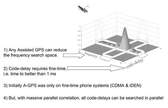
    Now let’s look at this code/frequency search in more detail, and introduce the concepts of fine time, coarse time, and massive parallel correlation. Any assistance data helps reduce the frequency search. The frequency search is just as you might scan the dial on a car radio looking for a radio station — but the different GPS frequencies are affected by the satellite motion, their Doppler effect. If you know in advance whether the satellite is rising or setting, then you can narrow the frequency-search window.

    The code-delay is more subtle. The entire C/A code repeats every millisecond. So narrowing the code-delay search space requires knowledge of GPS time to better than one millisecond, before you have acquired the signal. We call this “fine-time.”

    Only two phone systems had this time accuracy: CDMA and iDEN, both synchronized to GPS time. The largest networks (GSM, and now 3G) are not synchronized to GPS time. They are within 62 seconds of GPS time; we call this “coarse-time.” Initially, only the two fine-time systems adopted A-GPS. Then came massive parallel correlation, technology number two, and high sensitivity, technology number three.

    #2, #3. MPC, High Sensitivity

    A simplified block diagram of a GPS receiver appears in Figure 2. Traditional GPS (prior to 1999) had just two or three correlators per channel. They would search the code-delay space until they found the signal, and then track the signal by keeping one correlator slightly ahead (early) and one slightly behind (late) the correlation peak. These are the so-called “early-late”correlators.


    FIGURE 2. Massive parallel correllation
    FIGURE 2. Massive parallel correllation.

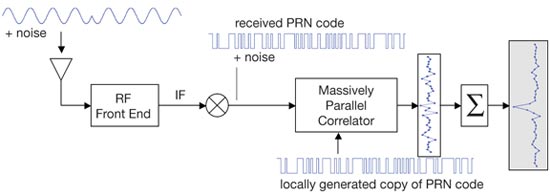
    Massive parallel correlation is defined as enough correlators to search all C/A code delays simultaneously on multiple channels. In hardware, this means tens of thousands of correlators. The effect of massive parallel correlation is that all code-delays are searched in parallel, so the receiver can spend longer integrating the signal whether or not fine-time is available.

    So now we can be faster, longer, higher, regardless of the phone system on which we implement A-GPS.

    Major milestones of massive parallel correlation (MPC):

    • In 1999, MPC was done in software, the most prominent example being by Snaptrack, who did this with a fast Fourier transform (FFT) running on a digital signal processor (DSP). The first chip with MPC in hardware was the GL16000, produced by Global Locate, then a small startup (now owned by Broadcom).
    • In 2005, the first smartphone implementation of MPC: the HP iPaq used the GL20000 GPS chip. Today MPC is standard on GPS chips found in mobile phones.

    #4. Coarse-Time Navigation

    We have seen that A-GPS assistance relieves the receiver from decoding orbit data (making it faster), and MPC means it can operate with coarse-time (longer, higher).

    But the time-of-week (TOW) still needed to be decoded for the position computation and navigation: for unambiguous pseudoranges, and to know the time of transmission. Coarse-time navigation is a technique for solving for TOW, instead of decoding it. A key part of the technique involves adding an extra state to the standard navigation equation, and a corresponding extra column to the well known line-of-sight matrix.

    The technical consequence of this technique is that you can get a position faster than it is possible to decode TOW (for example, in one, two, or three seconds), or you can get a position when the signals are too weak to decode TOW. And a practical consequence is longer battery life: since you can get fast time-to-first-fix (TTFF) always, without frequently waking and running the receiver to maintain it in a hot-start state.

    #5. Low Time-of-Week

    A parallel effort to coarse-time navigation is low TOW decode, that is, lowering the threshold at which
    it is possible to decode the TOW data. In 1999, it was widely accepted that -142 dBm was the lower limit of signal strength at which you could decode TOW. This is because -142 dBm is where the energy in a single data bit is just observable if all you do is integrate for 20 ms.

    However, there have evolved better and better ways of decoding the TOW message, so that now it can be done down to -152 dBm. Today, different manufacturers will quote you different levels for achievable TOW decode, anywhere from -142 to -152 dBm, depending on who you talk to. But they will all tell you that they are at the theoretical minimum!

    #6, #7. Host-Based GPS, RF-CMOS

    Host-based GPS and RF-CMOS are technologies six and seven, if you’re still counting with me. We can understand the host-based architecture best by starting with traditional system-on-chip (SOC) architecture. An SOC GPS may come in a single package, but inside that package you would find three separate die, three separate silicon chips packaged together: A baseband die, including the central processing unit (CPU); a separate radio frequency tuner; and flash memory. The only cost-effective way of avoiding the flash memory is to have read-only memory (ROM), which could be part of the baseband die — but that means you cannot update the receiver software and keep up with the technological developments we’ve been talking about. Hence state-of-the-art SOCs throughout the last decade, and to date, looked like Figure 3.

    FIGURE 3. Host-based architecture, compared to SOC
    FIGURE 3. Host-based architecture, compared to SOC.

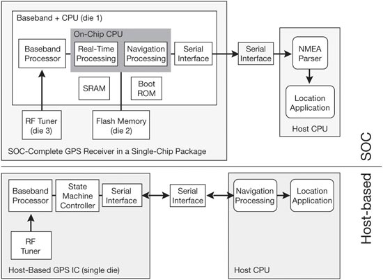
    The host-based architecture, by contrast, needs no CPU in the GPS. Instead, GPS software runs on the CPU and flash memory already present on the host device (for example, the smartphone). Meanwhile, radio-frequency complementary metal-oxide semi-conductor (RF-CMOS) technology allowed the RF tuner to be implemented on the same die as the baseband. Host-based GPS and RF- CMOS together allowed us to make single die GPS chips.

    The effect of this was that the cost of the chip went down dramatically without any loss in performance.

    Figure 4 shows the relative scales of some of largest-selling SOC and host- based chips, to give a comparative idea of silicon size (and cost). The SOC chip (on the left) is typically found in devices that need a CPU, while the host-based chip is found in devices that already have a CPU.


    FIGURE 4. Relative sizes of host-based, compared to SOC
    FIGURE 4. Relative sizes of host-based, compared to SOC.

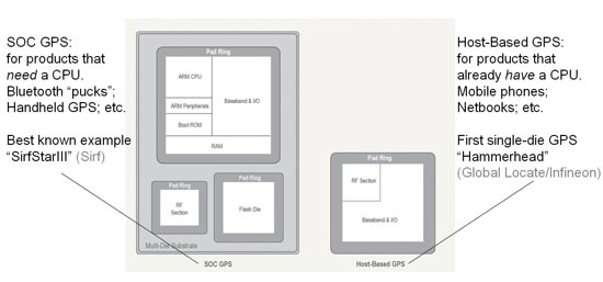
    In 2005, the world’s first single-die GPS receiver appeared. Thanks to the single die, it had a very low bill of materials (BOM) cost, and has sold more than 50 million into major-brand smartphones and feature phones on the market.

    Review

    We have seen that E-911 was the big catalyst for getting GPS into phones, although initially only in CDMA and iDEN phones. E-911 became the driver for all phones once GPS evolved far enough, thanks to the seven technology enablers:

    • A-GPS >> faster, longer, higher
    • Massive parallel correlation >> longer, higher with coarse-time
    • High-sensitivity >> cheap antennas
    • Coarse time navigation >> fast TTFF without periodic wakeup
    • Low TOW >> decode from weak signals
    • Host-based GPS, together with
    • RF-CMOS g single die.

    Meanwhile, as all this developed, several important spin-off technologies evolved to take this technology beyond the mobile phone. The most significant of all of these was long-term orbits (LTO), conceived on May 2, 2000, and now an industry standard.

    Long-Term Orbits

    Why May 2, 2000? Remember what happened on May 1, 2000: the U.S. government turned off selective availability (SA) on all GPS satellites. Suddenly it became much easier to predict future satellite orbits (and clocks) from the observations made by a civilian GPS network. At Global Locate, we had just such a network for doing A-GPS, as illustrated in Figure 5. On May 2 we said, “SA is off — wow! What does that mean for us?”And that’s where LTO for A-GPS came from.

    FIGURE 5. Broadcast ephemeris and long-term orbits
    FIGURE 5. Broadcast ephemeris and long-term orbits.

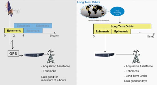
    Figure 5 shows the A-GPS environment with and without LTO. The left half shows the situation with broadcast ephemeris only. An A-GPS reference station observes the broadcast ephemeris and provides it (or derived data) to the mobile A-GPS receiver in your mobile phone. The satellite has the orbits for many hours into the future; the problem is that you can’t get them.

    The blue and yellow blocks in the diagram represent how the ephemeris is stored and transmitted by the GPS satellite. The current ephemeris (yellow) is transmitted; the future ephemeris (blue) is stored in the satellite memory until it becomes current. So, frustratingly, even though the future ephemeris exists, you cannot ordinarily get it from the GPS system itself.

    The right half of the figure shows the situation with LTO. If a network of reference stations observes all the satellites all the time, then a server can compute the future orbits, and provide future ephemeris to any A-GPS receiver. Using the same color scheme as before, we show here that there are no unavailable future orbits; as soon as they are computed, they can be provided. And if the mobile device has a fast-enough CPU, it can compute future orbits itself, at least for the subset of satellites it has tracked.

    Beyond Phones. This idea of LTO has moved A-GPS from the mobile phone into almost any GPS device. Two of most interesting examples are personal navigation devices (PNDs) in cars, and smartphones themselves that continue to be useful gadgets once they roam away from the network. Now, of course, people were predicting orbits before 2000 — all the way back to Newton and Kepler, in fact. It’s just that in the year 2000, accurate future GPS orbits weren’t available to mobile receivers. At that time, the International GNSS Service (IGS) had, as it does now, a global network of reference stations, and provided precise GPS orbits organized into groups called Final, Rapid and Ultra-Rapid. The Ultra-Rapid orbit had the least latency of the three, but, in 2000, Ultra-Rapid meant the recent past, not the future.

    So for LTO we see that the last 10 years have taken us from a situation of nothing available to the mobile device, to today where these long-term orbits have become codified in the 3rd Generation Partnership Project (3GPP) and Secure User Plane Location (SUPL) wireless standards, where they are known as “ephemeris extension.”

    Imagine

    GPS is now reaching 100 percent penetration in smartphones, and has a strong and growing presence in feature phones as well. GPS is now in more than 300 million mobile phones, at the very least; credible estimates range above 500 million.

    Now, imagine every receiver ever made since GPS was created 30 years ago: military and civilian, smart-bomb, boat, plane, hiking, survey, precision farming, GIS, Bluetooth-puck, personal digital assistant, and PND. In the last three years, we have put more GPS chips into mobile phones than the cumulative number of all other GPS receivers that have been built, ever!


    Frank van Diggelen has worked on GPS, GLONASS, and A-GPS for Navsys, Ashtech, Magellan, Global Locate, and now as a senior technical director and chief navigation officer of Broadcom Corporation. He has a Ph.D. in electrical engineering from Cambridge University, holds more than 45 issued U.S. patents on A-GPS, and is the author of the textbook A-GPS: Assisted GPS, GNSS, and SBAS.
  • Expert Advice: Availability Gaps: Solutions for Aviation

    Directions 2010

    James L. Farrell
    James L. Farrell

    By James L. Farrell

    Recent attention given to aging GPS satellites and availability gaps from lagging constellation replenishment have provoked deep concern, particularly within the aviation community. Available remedies include exploitation of well known but unused methods plus new techniques; those discussed here have future relevance, with or without availability gaps.

    Even with far greater coverage from multiple GNSS, crises could emerge from severely stronger interference levels or other unforeseen events. Advance preparation for any such occurrence would avoid the waste, confusion, and blind alleys that generally arise with the sudden appearance of an emergency.

    GPS lives up to expectations, brilliantly performing as advertised. Even that best-ever performance must and does have tolerance for occasional error; examples, though rare, are well documented. To live with less than perfect performance, the industry relies on integrity testing: comparison checks using extra satellites to detect inconsistencies and exclude questionable data.

    Nevertheless, it is universally recognized that GNSS, even with existing fault detection and isolation or exclusion (FDI/FDE), is still not perfect. The ramifications of growing dependence on GPS have thus attracted more attention. The overall subject can be subdivided into general areas involving the likelihood of:

    • reduced availability and
    • reduced dependability (integrity, its verification, plus backup).

    Although I mainly address the first topic here, the second unavoidably intertwines itself, making it difficult to keep them separate. Despite wide acclaim for the excellent 2001 Volpe Report, commitment to a key means of backup for GPS remains unclear at this time. Possibility of a shortfall calls for a review of both existing methods and procedures, and possible means for closing the gap.

    Current Methods

    Today’s air traffic management  designs demand constant replenishment of instantaneous position by full fixes.

    Full Fix 1 RAIM. When each data vector must be a self-sufficient source of instantaneous position, a requirement arises for enough satellite sightline directions with geometric spread at all times. That interdependence is magnified when more satellites are added to provide FDI/FDE, requiring every subset of four within the enlarged group to support the requisite geometry. With this all-or-nothing posture, data lapses form a major stumbling block. A data gap that is only partial equates to a loss of GPS.

    Position-Oriented Approach. Especially at high speeds, as in flight, instantaneous position is highly perishable. With little or no emphasis placed on accurate dynamics (beginning with velocity), demand for continuously accurate instantaneous position is highly dependent on abundant data. That abundance includes sufficiently high data rates, since latency becomes a significant liability without usage of a dynamic file.

    Carrier Phase (Classical). Successful use of carrier-phase information is decades old. Although ambiguity resolution is not required in all carrier-phase applications, requirements for cycle-slip detection are quite common. More common yet — in fact, virtually ubiquitous — is the need to maintain phase continuity via a carrier-track loop. When those needs are satisfied, sub-wavelength instantaneous position is obtainable. Challenges involved, however, have produced among users a wide variation in perception of value. Some negative perceptions have arisen due to cutting corners in formation of carrier phase, or merely settling for delta range, by some receivers. Further, a cycle slip, even if only rarely overlooked, can be catastrophic in some operations.

    Imperfect Validation. As already noted, verification is not my main topic here, but the issue is inescapable. Shortcomings include hard evidence of certification improperly bestowed, and severe limitations of go/no-go criteria (as with an automobile’s dashboard warning lights, we can learn if a performance trait is unsatisfactory — but a trivial excess produces the same indication as an imminent danger).

    Necessary Changes

    Extremely powerful and versatile means to improve performance have been available for a very long time. Kalman’s original paper, half a century ago, formalized an optimal way to achieve such performance. While Kalman estimation is commonly used today, its effective reach is almost invariably limited to data resident within each proprietary box of equipment.

    The resources for providing centrally processed solutions for data from every source of information available, any combination of sources, any subset that may exclude any sensor or group, or any individual source in a federated configuration, are well known. Every conceivable choice from among these solutions can be made concurrently available; note the inherent backup.

    However, all this capability is forsaken or lost by continued use of:

    • interfaces chosen poorly or from outdated standards;
    • undue consolidation within isolated equipment packaging;
    • overextended proprietary rights; and
    • limited, demonstrably flawed validation methods.

    Drop Demands for Full Fix. An immediate explosion of benefits can follow from acceptance of partial information. Countless examples could be cited, but two obvious ones suffice:

    • Within GPS or GNSS, not all space vehicles (SVs) would be simultaneously affected by scintillation; ionospheric disturbance effects vary with both location and time. A similar case holds for multipath. Data from some SVs could be rejected, by decisions made external to a receiver, without forcing rejection of all.
    • Central processing — not within any one equipment box — has always offered potential for other sources (distance-measuring equipment or DME, and so on) to make up for incomplete sets of SV data.

    My broad goal here is to take advantage of information not currently used and to prescribe corrective strategies. That objective has not been widely pursued due to perceived lack of urgency. GPS availability has thus far been more than satisfactory to a multitude of users — but that could change.

    Availability Enhancements. For about two decades, the industry was effectively guided by a strong preference for the trait whereby every data refresh event was self-sufficient. A major reason for this was protection against gradual veering: a snapshot sequence is less sensitive than a continuously evolving path estimate. The cost, of course, is forfeit of benefits conferred by the sequence’s history. More recently, a middle ground was sought to mitigate the resulting loss; subfilters used as much new data as possible while making some use of knowledge from an estimator’s covariance matrix.

    I promptly endorsed that approach and sought to carry it to the limit. A single-measurement receiver-autnomous integrity monitoring (RAIM) resulted, offering an independent integrity test for each separate observation. Despite its rigorous derivation, the technique is quite simple in practice. Further, it bridges a gap that formerly separated integrity test from optimal estimation, while also having significant advantages over conventional RAIM:

    • separation translates to independence from other satellites, and therefore from geometry (effective DOP of unity)
    • ability to use different error variances for different observations (for example, with nonuniformity in signal strength and/or elevation).

    With this discussion, we have clearly left the realm of well-known subjects with self-evident prescriptions. Much of what follows likewise falls into the category of relatively obscure methods.

    Beyond Position-Oriented. A time history
    of GNSS observations, with or without an inertial measurement unit (IMU), inherently carries dynamic information. A file with observational history from multiple sources of course enables the aforementioned explosion of benefits. The obvious immediate offerings include:

    • closing of data lapses via information sharing;
    • intrinsic backup with automatic activation;
    • vast reduction of latency effects (for example, from 200 meters to less than 1 meter at 400 knots after 1 second, with easily obtainable velocity accuracy below 1 meter/second);
    • formation of 1-sigma projected future error (within reason).

    Beyond these lie, once again, some lesser known techniques, including a few that are virtually nonexistent in operation at the time of this writing. With GNSS, the full potential of dynamics calls for a revisit of carrier phase.

    Carrier-Phase Developments. Rather than pursuit of unnecessary sub-wavelength fixes for aircraft (for example, with 20-meter wing span moving at 400 knots), the true value of carrier phase in flight lies in enhanced dependability.  Sequential changes in carrier phase over 1 second provide excellent dynamics information, with or without an IMU.

    Recognition of this opportunity led to the concept of segmentation, whereby position is determined separately from dynamics. Carrier-phase sequential changes with ambiguities unresolved can provide precise (1-centimeter/second RMS with IMU; decimeter/second without) streaming velocity independent of position. Dead reckoning then provides a priori position correctible by pseudoranges.

    One advantage of this scheme is subtle: with 1-second phase change propagation effects generally at 1 centimeter or less, no mask is needed. The geometry benefit is obvious, and flight experience has verified it. This raises another segmentation characteristic: the single-measurement integrity testing is applicable to each carrier-phase sequential change and to each pseudorange, separately and independently.

    These capabilities are untapped in essentially all operational systems — air, land, and sea — and all stand to gain. Yet another opportunity can be added: ability to sustain operation even if every SV has repetitive data gaps. This advantage is best exploited with receivers described next.

    FFT-Based Processing. Correlators and track loops in GNSS receivers can be replaced. The theory is age-old: multiplication in the frequency domain corresponds to convolution in time (and vice-versa). Thus a term-by-term product of a digitized receiver input’s fast Fourier transform (FFT) with the reference pattern’s FFT can, after an inverse FFT, provide outputs equivalent to full sets of correlator responses. Today’s processing and analog-to-digital converter capabilities offer feasibility.

    In addition to reduced vulnerability to jamming (not covered here), advantages include:

    • access to all cells (not only a track loop’s subset)
    • guaranteed access (stability is not conditional)
    • linear phase-versus-frequency; no phase distortion.

    Features from the preceding section, combined with these traits, offer extreme robustness.

    Extension to Surveillance. The practice of transmitting responses to RF interrogations has, for many decades, been quite vulnerable to overload (garble; one user’s information is everyone else’s interference). One report described the unsurprisingly poor performance during the first Gulf War, and identified a remedy: squitters with separate assigned time slots, spontaneously firing the transponder transmitter without interrogation. Immediately, a sea change in capability offers every participant an opportunity to track every other participant. With no interrogations, garble would disappear.

    This dramatic increase in capacity has been successfully demonstrated with the use of an existing communication link and existing airborne equipment: GPS receivers and Mode S squitters. Subsequently I enthusiastically advocated adoption of the technique with one fundamental modification: replace the data bits of the transmitted messages with measurements instead of coordinates.
    Additional improvements include small shifts in time (reducing bits needed for time tags) and recomputation of measurements that would have occurred at the center of gravity (to mitigate rotation effects). Collectively, the full set of procedures offers a vast and compelling list of benefits.

    Conclusions

    Capability and dependability of navigation and surveillance can be enormously increased. The key lies not in new inventions nor provisions, but in use of newer methods, (among them, FFT-based receivers, segmented estimation, and 1-second carrier-phase changes) while abandoning habits such as:

    • dismissal of partial fix data
    • preoccupation with full fixes for instantaneous position irrespective of dynamics
    • preference for location pseudomeasurements rather than the measurements themselves
    • reliance on proprietary software in equipment boxes
    • RF interrogation/response sequences instead of squitters.

    The industry can either adopt changes or continue to settle for performance levels at a minor fraction of the intrinsic capabilities available from our present and future systems.


    James L. Farrell worked for 31 years at Westinghouse in design, simulation, and validation of navigation and tracking programs. He continues teaching and consulting for private industry, the Department of Defense, and university research through Vigil, Inc

  • As Loran Fades, Attention Shifts to DGPS and SBAS

    Few precise-positioning users have employed Loran in a professional sense, although maybe you have in your personal life if you’re a airplane pilot or a mariner. Then again, if you’ve flown as an airline passenger or cruised onboard a ship, you’ve benefited from the back-up to GPS that Loran provides. Similarly, if you’ve used a mobile phone recently; you don’t see it, but the wireless carriers all use Loran as a back-up. That back-up is about to go away.

    Loran was developed initially for marine navigation and then adopted for aviation navigation. I used Loran-C for aviation navigation in the early 90’s after I earned my private pilot’s license. It was much easier than triangulating off of VORs and NDBs. Yes, GPS receivers for aviation were starting to emerge at that time but flying is expensive so a hand-held GPS was an out-of-reach luxury for a newlywed who just bought his first house and was preparing to start a family.

    Loran is a terrestrial (ground-based) system of broadcasting towers, somewhat synonymous with NDGPS. You can read details about the system in the link I provided, but essentially it’s a line-of-sight system in which the Loran receiver antenna needs a direct path to the tower to utilize the signal. Coverage depends on the density of the broadcasting towers. Some regions are covered better than others and when I was using it, there were many areas that were not covered. Accuracy is always an ambiguous subject with respect to navigation technologies, so I’ll go out on a limb and say that Loran-C accuracy is repeatable to about 20 meters. A proposal was floated to upgrade Loran to a system called e-Loran which is reportedly accurate to about 9 meters.

    Anyway, over the past several years there’s been a discussion about what to do with the Loran system because it’s clear that GPS has supplanted Loran as the primary navigation system for marine and aviation. Several articles have been published in GPS World by industry experts with most being in favor of maintaining Loran. The primary argument is that we need a back-up system for GPS, not only for navigation, but for the many invisible ways that GPS supports the national infrastructure (financial networks, wireless communications, transportation).

    Here are several relevant articles, from most recent to further back:

    New Backward-Compatible Technique to Develop GPS+eLORAN User Base

    Coast Guard Jettisons Loran

    LORAN: What the President Meant to Say Was…

    Loran Study Finally Unleashed: Says Keep It, Best Option

    eLoran, Superhero Sidekick

    Loran Gets a Witness

    The Case for eLoran

    In addition to these articles , the U.S. government publishes the Federal Radionavigation Plan (FRP) roughly on a biennial basis. There was one published in 2001, then 2005 and the last one was published in 2008/early 2009. It is the official policy document in which all US navigation systems are planned. According to the FRP, it is prepared jointly by the Department of Defense, Department of Homeland Security, the Department of Transportation and a number of other contributing government agencies.

    If you don’t have time to read the 2008 FRP, following is a telling statement from the document:

    “In March 2007, the DOT Pos/Nav Executive Committee and the DHS Geospatial/PNT Executive Committee accepted the findings of the Institute for Defense Analysis’ Independent Assessment Team and approved to pursue the designation of Enhanced-Loran, commonly referred as eLoran, as a national PNT backup for the U.S. homeland.

    At its March 2007 meeting, the National Space-based PNT ExComm supported this approach and tasked DOT and DHS to complete an action plan that includes identifying an executive agent, developing a transition plan to address funding and operations and requesting the approval by the DOT and DHS Secretaries resulting in a final decision. DoD has not approved eLoran as a GPS backup for military applications.

    In March 2008, the National Space-based PNT ExComm endorsed the DOT/DHS decision to transition the LORAN system to eLoran.

    With respect to transportation to include aviation, commercial maritime, rail, and highway, the DOT has determined that sufficient alternative navigation aids currently exist in the event of a loss of GPS-based services, and therefore Loran currently is not needed as a back-up navigation aid for transportation safety-of-life users. However, many transportation safety-of-life applications depend on commercial communication systems and DOT recognizes the importance of the Loran system as a backup to GPS for critical infrastructure applications requiring precise time and frequency.

    Currently, DHS is determining whether alternative backups or contingency plans exist across the critical infrastructure and key resource sectors identified in the National Infrastructure Protection Plan in the event of a loss of GPS-based services. An initial survey of the Federal critical infrastructure partners indicates wide variance in backup system requirements. Therefore, DHS is working with Federal partners to clarify the operational requirements.”

    By the way, that Independent Assessment Team mentioned in the first paragraph was led by Brad Parkinson, who knows someting about GPS. Further, the government read the report behind closed doors but refused to release it, until forced to do so nearly two years later, by public information access filings.

    There still aren’t any answers to the question about a real back-up to GPS. No doubt it’s a vulnerable system. But that’s a subject for another day.

    What’s Loran got to do with us?

    The reason I’m writing about this is because as support for Loran wanes, attention (resources and focus) shifts away from Loran, it comes to bear more intensely on GPS navigation and its augmentations for marine and aviation; specifically DGPS and SBAS (WAAS/EGNOS/MSAS).

    With a significant policy shift such as this (albeit it has been in the cards), manufacturers stop allocating engineering development resources to the products/technologies with a dim future and shift those resources to products/technologies with a bright future. True, DGPS has been around for better than a decade and SBAS for about half that time so there’s been plenty of time for manufacturer’s to exploit those technologies, but there is still a lot that can be done.

    Engineers are experimenting with and implementing technologies in some interesting areas.

    HA-NDGPS. High accuracy NDGPS. Currently with a high performance DGPS receive
    r, one can attain about meter-level accuracy. Testing with HA-NDGPS, using a dual frequency GPS receiver shows that accuracies in the 10cm (95%) horizontal and 20cm (95%) vertical range are achievable within a 100 mile baseline according to the US DOT Federal Highway Administration Turner-Fairbank Research Center. Test broadcasts are being sent from a site in Hagerstown, MD.

    Broadcasting DGPS/SBAS corrections via NTRIP. The emergence of RTK Networks has spurred the popularity of using the internet to deliver GPS corrections. NTRIP has become a commonly used method of accomplishing this. One of the weak points of DGPS technology has been the reliability and expense of broadcasting DGPS corrections via the 283-325kHz band. Of course, with NTRIP one must have internet access somehow and that typically happens via WiFi or GSM/CDMA mobile phone network. But it’s not that complicated. I’ve been with a GPS user who has pulled the SIM card from their iPhone, plugged it into a GPS receiver, and begin receiving DGPS corrections immediately.

    During my last webinar, someone had posed the question if receiving SBAS corrections is possible via the internet in order to bypass the requirement to maintain visibility of the SBAS geostationary satellite. Streaming SBAS corrections via the internet is already happening in Europe. Users can access EGNOS corrections and bypass the EGNOS geostationary satellites by using SISNeT. A similar type of system could be implemented for any SBAS and not necessarily by the SBAS service provider. It could be a commercial entity.

    I think the internet and GSM/CDMA mobile phone networks are really going to transform the way we transport data from reference stations to our receivers in the field. We’ve been fighting this battle of delivering GPS corrections for better than a decade. In the past, we’ve experimented with FM pagers and landline modems and now we’ve settled on low frequency radiobeacon, VHF/UHF/Spread spectrum and geostationary satellites but none are close to the perfect solution. GSM/CDMA mobile phone networks may be the final solution as the networks continue to build-out towards complete geographic coverage. Of course, we are helped immensely by the mobile phone industry whose focus on data for the many new social networking applications will drive the price of data plans downward.

    By the way, almost all wireless carriers use Loran as a back-up technology; highly precise timing is a key aspect of how wireless communication works. The carriers use GPS for that, but if GPS goes down — as it did in San Diego during a memorable jamming episode a few years ago — so do all cell phones, if the carriers don’t have a timing back-up. In San Diego, they didn’t. Just something to think about, if you are using your mobile phone network to transport data or receive corrections.

  • A Little Q&A Follow-up and Feedback on My Last Column

    I received some feedback on my last column entitled “What’s the Difference Between a Used Car Salesman and a GPS Salesman?” Most of the comments were positive in that the technical content was reasonably deep and thorough. However, I did receive a couple of e-mails from folks who were offended by the comparison.

    The joke has been around for a long time. As I mentioned, I recall hearing it in the early ’90s. I believe it was while I was at a conference somewhere in British Columbia, Canada. Anyway, I used to be a GPS salesman of sorts and I never took offense to it. I figured if I was doing my job correctly, there was nothing to be offended by. But, the fact is the joke has maintained staying power because a number of people do exist who fit that description. Fortunately, they don’t seem to hang around very long in the industry. On the flip side, over the years I’ve met many competent GPS sales professionals that have earned my trust. Many of whom I consider my friends.

    Leftover Webinar Q&A

    There are some lingering questions left over from the last webinar (September). There are still a few questions left after this that I’ll post in future newsletters.

    Question #1: If GLONASS has a full constellation by 2020, would it be fair to say a L1, L2, and GLONASS receiver would be fine because you would really only have a L1 and
    GLONASS receiver thus therefore enough sats?

    Gakstatter: The question is referring to the semicodeless sunset I’ve written about in the past. You can read about it here.

    Back to the question. Generally speaking, I would say yes but it’s going to depend on the receiver firmware design. If the receiver is optimized to depend on L2, then the firmware would have to be altered. Then, the question is whether the manufacturer is willing to update the firmware.

    Question #2: If SBAS is made for aviation safety purposes, why it does not cover all of the world? Will the coverage expand in the future?

    Gakstatter: Building an SBAS is very expensive and time-consuming project. If I recall correctly, the US WAAS total expenditure to date is well into several billion dollars. The FY2010 annual budget for WAAS is just under US$100M.

    The nature of SBAS is that they are regional systems. Currently, there are three. WAAS covers most of North America. EGNOS covers most of Western Europe and North Africa. MSAS covers the region around Japan. GAGAN is still in the planning stage and will cover India and surrounding areas.

    This still leaves South America, Australia, and Africa as major land masses not covered by SBAS.

    MSAS has the potential to cover Australia and EGNOS has the potential to cover Africa. Whether that happens or not is more political and financial than technical issues.

    Also, once GPS L5 is broadcast by a full constellation, the requirement for SBAS for aviation will diminish because GPS in aviation will transition to dual frequency (L1/L5) thus mitigating the effects of the ionosphere.  However, there would still be a question about position integrity, which is a central function of SBAS. The debate within some countries that do not currently have SBAS coverage is whether to invest in a SBAS or hold out for GPS L5. However, a full satellite constellation broadcasting GPS L5 will not be operational until ~15 years from now.

    Question #3: Can we obtain SBAS in other regions in the future?

    Gakstatter: India is far along with their GAGAN SBAS. At one point, a test signal was being broadcast. Within the next few months, India reportedly will be launching a geostationary satellite for GAGAN.

    Russia is reportedly in the early stages of developing their SBAS called SDCM (System of Differential Correction and Monitoring).

    The interoperability among SBAS is virtually seamless. A GPS receiver utilizing WAAS in North America is able to use EGNOS in Europe and MSAS in the Japanese region. Most receivers will automatically tune to the local SBAS given the SBAS satellites in view. However, some must be manually set to “look” for the SBAS satellite(s) of that region.

    Question #4: GNSS improves the productivity. What about the precision? Are there any reports testing/comparing GPS vs GNSS?

    Gakstatter: At this point, the ideal situation would be to only utilize GPS satellites. The quality, integrity and monitoring is world-class. Unfortunately, for RTK users there just aren’t enough of them in orbit to be able to work consistently throughout the day.

    The quality and reliability of GLONASS measurements aren’t as good as GPS yet. The ephemeris data and clock corrections are worse and there isn’t world-wide monitoring of the satellites. Russia’s program managers have stated they are striving to reach the same measurement quality as GPS.

    So, the short answer is no, I wouldn’t expect GPS/GLONASS to improve positioning precision. However, it also depends on the scenario. If the comparison is between a GPS constellation of 5 satellites with a PDOP of 5 against a GPS/GLONASS constellation of 5 + 5 with a PDOP of 2, then I’d vote for the latter.

    There is an extensive report available from The Survey Assocation in the UK. Although it focuses on Network RTK, there’s a valuable discussion in it regarding GLONASS. You can download the report here.

    Question #5: By 2020, is the DOD going to completely get rid of L2 signal?

    Gakstatter: No, not at all. L2 was never intended for use by the civilian community. However, in the 1980’s, some really smart scientists in the commercial sector figured out a way to gain access to the encrypted L2 signal via a technique is referred to as semicodeless.

    Since that time, the Department of Defense (DOD) has respected that technique because it’s been vitally important in the development of the GPS commercial markets. By respected, I mean they have intentionally not made changes to the GPS that would disrupt the semicodeless technique.

    The DOD has now has come to a point that dancing around the semicodeless issue has become a bigger liability than they want to assume. That’s understandable since L2C will allow dual frequency GPS receivers to utilize L2 without using semicodeless techniques, the DOD wants to be released of their liability with respect to L2 semicodeless.

    So, after December 31, 2020, the DOD will no longer guarantee that semicodeless receivers will operate as they do today. It is not a “brick wall” in that it will stop working at midnight on December 31, 2020. In fact, a semicodeless receiver may work perfectly fine most of the time after December 31, 2020, but if it stops working properly, the user assumes the liability.

    Off-topic

    One of the reasons my column is late this week is that I caught a bug earlier this week. It’s nothing serious; it’s just slowing me down a bit because I don’t have the energy I normally have. The fact is that I just don’t get sick beyond my tendency to attract strep throat once every few years.

    This year, I’ve opted out of the flu shot despite a specific call from my mother putting the heat on me to get one. I’ve never gotten a flu shot and probably never will. But, I do admit this is the first year I’ve actually considered it. At one point a few weeks ago, 25% of the primary and middle school-aged kids in our school district
    were absent due to illness. There were significantly fewer Trick-or-Treaters in our neighborhood this year; I believe due to illness.

    I’ve always made an effort to wash my hands, face, nose regularly (no, I’m not obsessive-compulsive) and pay attention to those around me when I’m in public places like malls, movie theaters and airplanes. I absolutely hate getting stuck sitting next to a person on an airplane who is coughing and sneezing. I remember specifically sitting next to a person on a flight back from Phoenix, Arizona, a half-dozen years ago. She looked like death warmed-over…coughing and sneezing horribly. Sure enough, the next day I could feel my body losing the battle. I ended up contracting strep. Ugh.

    Anyway, I want to remind you given that many of the US readers are traveling next week for the Thanksgiving holiday to take care of yourselves and your loved ones.  You’ll be traveling amongst those who haven’t escaped “the bug,” but have still decided to travel. Here are some tips from the Center for Disease Control and Prevention to keep you and your loved ones healthy.

  • ABB Selects Intergraph for North African Gas Pipeline Project

    ABB has selected Intergraph for the development of an oil and gas pipeline network and relevant facilities in North Africa. The pipeline network will be built in the El Merk field, a remote, harsh desert location in Algeria.

    According to Intergraph, geospatial-based pipeline infrastructure management solutions will enable ABB to more effectively design, construct and maintain pipelines and assets and demonstrate a comprehensive pipeline integrity program while reducing the cost of maintaining records. By storing records in a central geographic information system (GIS), the solution makes information readily available for a variety of applications, improving record keeping productivity while assuring compliance with regulatory requirements.

    “An accurate, up-to-date view of all critical assets at any given time is a crucial component of any pipeline implementation project,” said Sergio Casati, ABB Project Manager. “Especially in such challenging terrain conditions, we need to keep our pulse on the status of all assets in near real-time. The strength of Intergraph technology and its more than 40 years of experience in the utilities sector, as well as market leadership in enterprise engineering software, were key factors in our decision to partner with the company on this project. Intergraph’s open, flexible technology platform was also desirable for an initiative like the El Merk project, which involves a consortium of multiple vendors.”

    The announcement said that geospatial technology from Intergraph will play a significant role in the design and installation of the pipeline, field gathering stations, gas distribution manifolds, flow and trunk lines and water and gas re-injection facilities in El Merk. The technology will support the Pipeline Open Data Standard (PODS) model, the most widely implemented pipeline data model in the industry, and all data will be stored in an Oracle Spatial database. The implementation will also include a portal component for the seamless distribution of data to all parties, including field and remote users.

    “The collaboration of Intergraph with ABB Italy on this project marks a significant milestone in Intergraph’s involvement in the oil and gas pipeline industry,” said Maximilian Weber, Utilities & Communications manager for Intergraph in EMEA. “Intergraph has worked with leading pipeline providers around the world including Spectra Energy and Northwest Energy in the U.S., E.ON Ruhrgas in Germany and Chongqing Gas in China. Additionally, our Process, Power & Marine division is the world’s leading provider of enterprise engineering software for the design, construction and operation of plants, pipelines, ships and offshore facilities. We are pleased that ABB has recognized our strength in this industry and has chosen us to ensure the accurate, efficient management of assets, as well as play a key role in protecting this infrastructure.”

  • What’s the Difference between a Used Car Salesman and a GPS Salesman?

    Years ago, I heard a funny joke/maxim. I repeat it often and so do several others I know of so maybe you’ve heard it.

    “What’s the difference between a used car salesman and a GPS salesman?”

    Answer: The used car salesman knows when he’s lying to you.

    I didn’t attend the Minnesota GIS/LIS Annual Conference last week, but I received a report from someone who attended a session in which the presenter seemed to fit the maxim quite well. One of the presenter’s messages was that people should stop using WAAS immediately as a GPS correction source due to the inability of data collection software to handle the ITRF00 > NAD83/CORS96 datum shift. Following is a statement from one of his slides…

    “WAAS Real-time accuracy degraded because of datum shift”

    He claimed that users are “in a panic over it.” In all fairness, the presenter could have very well understood that the datum shift can be handled by a number of data collection software packages…just not the one he represents. After all, he works for a local distributor of GPS equipment. Or, even a scarier scenario would be that he really believed what he spoke.

    I’m not interested in naming names or company names of the offending party, but rather painting the true picture. Of course, the attendee I mentioned above knew better than to believe what the presenter was pitching. His group has been using WAAS as a primary correction source for a number of years and reconciling the datum shift between ITRF00 and NAD83/CORS96. It’s not that hard folks.

    Let’s review.

    ITRF00 is essentially the same as WGS-84(G1150) for sub-meter mapping purposes. WAAS (as well as EGNOS and MSAS) are referenced to ITRF00. You need to be aware that the definition of ITRF/WGS-84 has changed over time. Here is a link to a NIMA WGS-84 document that describes earlier versions of WGS-84 and here’s a link to the current version of WGS84 (G1150) that was adopted in 2002.

    In North America (my apologies to readers from other countries), the generally accepted mapping datum is NAD83. NAD83 has also changed substantially over time. Whereas the original WGS-84 was consistent with the original NAD83 (NAD83/86), today there is a substantial difference between the current WGS-84(G1150) and NAD83/CORS96 and also NAD83/NSRS2007. Here is a graphic from Joel Cusick of the U.S. National Park Service that gives you an idea of the difference over North America:

    Here is a link to a technical report from the National Geodetic Survey (NGS) describing the 14-parameter transformation from ITRF00/WGS-84(G1150) to NAD83/CORS96.

    Sadly and surprisingly, some data collection software today and even some PC-based “GIS” software still treat WGS-84 and NAD83 as the same. This instantly introduces a few feet of error. The irony is that people spend thousands of dollars purchasing high-performance GPS/GIS receivers capable of sub-meter accuracy only to introduce several feet of error by using software that improperly handles the datum transformation.

    What’s the solution if your software doesn’t handle the datum transformation properly?

    As mentioned above, WAAS is based on the ITRF00 datum and not NAD83/CORS96. As most base maps in North America aren’t referenced to ITRF, most likely you’ll need to transform your WAAS-corrected coordinates to NAD83/CORS96. This can be done one of two ways:

    1. As mentioned above, use GPS/GIS data collection software that handles the transformation correctly. This makes the transformation transparent, painless to the user and accurate in real-time.
    2. Apply a datum shift after you’ve collected your data. You can compute the shift by accessing an NGS datasheet near your project area (within 25 miles is close enough). Make sure it was occupied using GPS. Better yet, use coordinates from a CORS. The datasheet will report coordinates in both ITRF00 and NAD83/CORS96. Here is an example of coordinates from the CORS at Wisconsin Point, WI (near Duluth where the MN GIS/LIS Annual Conference was held):

    ITRF00 Position (Epoch 1997.0) – N 46 42 18.20201, W 092 00 54.760208

    NAD83/CORS96 Position (Epoch 2002.0) – N 46 42 18.17201, W 092 00 54.73394

    Simply enter the two coordinates into your favorite mapping software and you’ll be able to compute the distance and direction of the difference.


    Once you know this, you can apply the same offset to all of the data for your project. Quick and dirty? Yes. We’re not splitting hairs. WAAS isn’t delivering cm-level accuracy so this sort of transformation is more than adequate…and very efficient.

    The fact of the matter is that many, many organizations have adopted WAAS as a primary source of GPS corrections and are dealing with this datum transformation issue on a daily basis.

    GPS Constellation Management: Playing Not to Lose

    The WAAS/SBAS subject segues perfectly into the second subject of this column which is a follow-up of last week’s column on GPS Constellation Management.

    Last week, I failed to mention that SBAS (WAAS, EGNOS, MSAS) is a valuable contributor to RTK users. Although not designed specifically to aid RTK ground users, some GPS receiver designers have exploited the value of SBAS satellites to enhance RTK operations. In North America, there are two SBAS satellites. In Europe, there are two and there are two in the Japan region. Following is a graphic depicting the regional coverage of the SBAS satellites and their approximate location.


    In many regions of the world, users have at least one SBAS satellite available in view. The beauty of SBAS satellites for RTK is that, unlike GPS satellites, SBAS satellites are geostationary. The are available 24/7 as long as their signal path isn’t blocked by trees, terrain or buildings.

    Since using SBAS satellites for RTK is a relatively new innovation within the past couple of years, not all manufacturers have jumped on the bandwagon yet. The slow adoption of GLONASS was similar. This causes a problem when users want to mix and match RTK receivers from different manufacturers. For example, a user purchases an SBAS-capable L1/L2 RTK rover to be used with their existing L1/L2 RTK reference station. If their existing L1/L2 RTK reference station doesn’t support SBAS for RTK, then the feature on their new RTK rover is worthless.

    Even more important is the lack of support from RTN software designers. “No one’s asking for it” is the answer I get from RTN operators when asked if they are interested in supporting SBAS correctors in their RTN. I believe that users aren’t asking for it because users don’t have a clue how it would help them, and frankly, 99% don’t know the technology even exists. Now, if you would ask users if they’d be interested in one or two extra observables for RTK that would be
    available 24/7 in a geostationary orbit every day, I bet you’d hear some really positive answers.

    RTK users need to be able to utilize every observable that could help them. As Rob Lorimer and I reported last year in our market research report, machine control (based on RTK) will be the fastest growing GNSS segment over the period 2008-2012.

  • GPS Constellation Management: Playing Not to Lose

    In sports, there is a phenomenon that sometimes occurs when a team is leading towards the end of a game. It’s called “playing not to lose”.

    For example, there’s five minutes left in a basketball game and a team is leading by ten points. The leading team wants to run the clock down as much as possible and still maintain their lead. There are two basic strategies the leading team can take. One is to continue being aggressive and using the strategy that put them in a winning position to begin with. The other strategy is to try to “play it safe” until the time clock expires. The problem with the latter strategy is that the other team can sense the change in mentality and feed off of it. It’s called “playing not to lose” instead of “playing to win”. I’ve seen it happen over and over again in team sports and in business. Once an organization has achieved a level of success, they lose the edge that brought them their success.

    The reason you are seeing high HDOP warnings from the NAVCEN and GPS “brownouts” during the day when RTK (GPS-only) isn’t working is because the GPS satellite constellation is sub-optimal. The current design of the GPS constellation is not focused on “playing to win”, but rather “playing not to lose”.

    Even the original GPS Program Manager, Dr. Brad Parkinson, has voiced his concern about GPS brownouts and discussed possible solutions. You can read one of his presentations here. In 2006, noted GNSS consultant John W. Lavrakas published a GPS World article entitled Managing the GPS Constellation for Today’s Needs discussing the disparity between the professional user community needs and GPS constellation management.

    Today, there are 28 operational satellites. There were 30, but PRN08 is offline for maintenance and PRN24 was placed in active reserve after an “unusual failure”. The 31st one, PRN01/SVN49, never has been declared operational since its launch last March due to the issues discussed here before. The current GPS ground control infrastructure can only handle 30 or 31 satellites.

    Given these limitations, GPS looks grim for the GPS-only RTK user, right?

    Not necessarily.

    The GPS constellation is optimized for 24 satellites. When there are more than 24 satellites in orbit, like there has been for many years, the extras are not positioned to benefit the users but rather to be in a position to replace satellite failures. They are sometimes referred to as “paired orbits”. Simply put, the active spares are orbiting very near other satellites that are most likely to fail. This does very little for the user community.

    The current discussion is not whether to launch more satellites, but rather how to reconfigure the satellites that are in orbit. Launching more satellites is a complicated issue. It’s not just an US Air Force (the GPS stewards) technical issue, but a political one because it’s expensive (~$150M per GPS satellite launch). That leaves the Air Force with the option of adjusting the GPS constellation to benefit the user community. Doing this is not completely void of political implications I’m sure, but certainly not near the risk of launching a new satellite and certainly a better bang for your buck to the user community.

    For many years in the GPS scientific community, there have been open discussions in the past of GPS constellations designed for 27 or 30 satellites. The good news is that this is an active discussion within the US Air Force today. It’s quite an important discussion because GPS-only RTK users are increasingly being shut down during the day due to the lack of GPS satellite signals and/or high PDOP. Even a constellation designed for 27 satellites would be a significant gain for GPS-only RTK users.

    During my webinar a month ago, I submitted to the audience the following question:

    “Do you or your crews experience GPS “brownouts” where you have to wait for the GPS constellation to change before you can continue using your GPS system?”


    The following results speak for themselves:


    Email me your experiences so I can continue to raise awareness of the impact the current GPS constellation is having on GPS-only RTK users. Tell me about your productivity loses, extra mission planning and other time spent dealing with the GPS “brown outs”.

    I’m doing my best to make the Air Force aware of that the current constellation is causing GPS-only RTK users a significant loss in productivity. I have a feeling that the Air Force looks at the millions of consumer GPS users who are happy with their Garmins, TomToms, Magellans, etc. because those folks are able to navigate from Point A to Point B with few difficulties given the current constellation. What the Air Force doesn’t realize are that the GPS demands from the professional user community are much higher. We are the infrastructure people. Without our accurate measurements, the consumer GPS community wouldn’t enjoy the benefits they have.

    RTK users need at least six satellites above 12 degrees and a PDOP below 3.0 for a robust solution. Furthermore, we have to deal with obstructions such as trees, buildings and terrain that will take out, on average, a couple of those. I think the Air Force plugs in a five degree elevation mask back in the office, looks at the sat visibility graph and says “hey, what are these guys complaining about?” The reality is that satellite signals low on the horizon don’t work as well because the data is noisier and many times rejected by the receiver. Secondly, we don’t work in parking lots where we have an unobstructed view of the horizon. We have to deal with trees, buildings and terrain that block satellite signals.

    And the answer is…

    At this point, there is only one solution for RTK users who need better productivity…GLONASS. As much as the Russians have taken a beating in the past for having an unreliable constellation, they hold the key for RTK productivity at this point as the GPS constellation continues to deliver “brownouts” that hamper productivity. It could turn out to be a boon for RTK receiver manufacturers. Although a few include GLONASS as a standard, most RTK receiver manufacturers charge an upgrade fee of several thousand dollars to utilize GLONASS. Even worse for some RTK users, their receiver isn’t upgradeable to utilize GLONASS so they would need to purchase a new receiver(s).

    On a final note, I just spoke to a user in the field who was using a GPS/GLONASS RTK receiver. I asked him to recite to me how many GPS and GLONASS satellites he was tracking. I suppose I shouldn’t be surprised, but it did saddened me a bit. He was tracking more GLONASS satellites (6) than GPS satellites (5). Sigh…


  • Geospatial Data Accuracy – Better and Better

    Circa. 1995. I walked into the GIS office of a major forest products company in northern Arkansas (or was it northern Louisiana…not sure). At the time, I was a product manager for a GPS company and field testing one of our newer GPS mapping hand-held products.

    We decided to go out and map the perimeter of a timber tract they owned to compare the area (acres) that the GPS calculated vs. what was in their GIS. This was nothing new as I’d done it many times for other companies. We went to the tract (adjacent to a road) and walked the boundary (~40 acres). Afterwards, we returned to their office and I post-processed the GPS data.

    I forget what the final area calculation was, but it was believable and the company didn’t challenge the result. Also, the shape of the polygon seemed reasonable. However, when the GIS manager inserted the GPS data into his GIS, it was offset a significant amount. I forget exactly, but something on the order of 50-100 feet. I immediately began considering if my data was the problem, but concluded the chance was low. For GPS post-processing, I’d tied into a local US Forest Service GPS base station so my GPS data was referenced to NAD83/86 (if I recall correctly). In the end, we agreed that my data was most likely positioned correctly.

    “So what?”, he said, “Do you think I’m going to adjust my entire GIS because it doesn’t agree with your GPS?” (I’m paraphrasing based on my recollection). I understood that I had won the battle, but lost the war. It didn’t matter that I was right, at least at that moment in time. However, he did agree with me that eventually he was going to have to reconcile the difference because GPS was destined to be the technology that defined the national spatial framework.

    I had many more experiences similar to the above during the mid-90’s. People would swear by the accuracy of USGS 1:24,000 quad sheets because that’s what they were used to. If the GPS data didn’t agree with the quad sheet, they’d dismiss the accuracy of GPS because it didn’t fit. This was particular true with utility companies too, that were some of the early adopters of CAD for mapping.

    Fifteen years later, this problem is not going away. The accuracy of Geospatial data continues to get better and better. Think back fifteen years and ask yourself about the quality/availability/price of orthophotography back then. I remember we were ecstatic to have access to free 1-meter, black/white DOQQs. Today, I can easily find 1’ pixel resolution orthophotography, commonly find 6” and occasionally run into 3” pixel resolution orthophotos free of charge. This allows one to digitize manholes and other infrastructure without leaving the seat at your GIS workstation.

    During the same period, the cost of accurate GPS measurements has reduced considerably. Whereas fifteen years ago, achieving sub-meter accuracy with a $12,000 mapping receiver was on the bleeding edge of technology. Today, a $2,000 mapping receiver can give you sub-meter results and a $6,000 receiver can achieve sub-foot accuracy. Looking way forward, the cost and availability of GPS accuracy is going to change significantly in the next 10 years. Obtaining one foot accuracy will be achievable with a very inexpensive GPS receiver.

    We all know that data drives a GIS. The better quality data we have, the more accurately and precisely and completely the GIS can answer our queries. Along these lines, I think it’s worth mentioning again the outcome of the litigation in California involving Santa Clara County and the ownership of GIS data.

    Santa Clara County GIS lawsuit

    Santa Clara County (California) was charging significant fees (potentially several hundred thousand dollars) to organizations who wanted to utilitize its full suite of GIS data including orthophotography, parcel, planning, streets, boundary, etc. A lawsuit was filed in 2006 by the First Amendment Coalition arguing that the GIS data should be released under the California Public Records Act. Santa Clara County argued that the GIS data was sensitive enough to be excluded due to homeland security issues (eg. making known the locations of critical infrastructure such as utilities). Santa Clara County lost the argument and was ordered by the court to hand over the GIS data. The 6th District Court of Appeal gave the final word last February.

    The outcome of the court case establishes a significant precedent in the geospatial industry. For as long as I can remember, this issue has been solidly ambiguous among state and local governments. One entity would email (or make available via FTP) GIS data at a moment’s notice. Another entity would have you sign away your first-born child. Even another would not entertain the thought of releasing “our data” to anyone. I think the attorney for Santa Clara County was accurate in stating “It was one of those cases that needed to be tried and for which we needed guidance from the court”. Normally, I have an anti-litigious attitude, but I’m happy to see a precedent has been established and publicized.

    Go on…be a TIGER

    After last week’s column about Google’s step forward in using their own base map for Google Maps/Earth in the US, I was admonished by a reader, and rightfully so, in not mentioning the value of Census data as an important part of the history of base map evolution in the US.

    Jon Sperling, Ph.D., GISP wrote:

    “It is quite disconcerting, from an historical and current perspective, that your article made no mention of the “pre-internet” Census TIGER database, the first topologically integrated national digital street centerline for the US or even the newly updated and positionally accurate TIGER files (with an associated but confidential file of GPS address points collected for every housing unit in the Nation). These files, newly updated for the 2010 Census, are still a major source for accurate and easily accessible public domain street level data for every community in the US, including Puerto Rico, the Virgin Islands, and other territories. More importantly, it was the innovation that spurred the GIS revolution across government, private industry, and academia by enabling every local agency, entity and person in the United States to build their own geographic information system by combining census data with TIGER. Prior to this development, the Census was also a leader in the development of the GBF/DIME Files which enabled address geocoding, a capability that led to the later success of Mapquest, Google, and others. Like the development of the internet by DARPA and the Global Positioning System also by the federal government, the widespread development of intelligent national street level mapping was also led by the government.  GDT/TeleAtlas began as a company that offered “enhanced” TIGER files and Navteq often used TIGER for the more rural areas. Not only has the Census pioneered but it remains a key catalyst and building block for delivering a cost-effective and truly integrated national spatial data infrastructure.”

    Attached is an article I wrote back in 1992 on the history/development of TIGER as well as a 2002 proposal for creating a shared national road network (geometry and basic attributes such as address range to enable consistent and shareable geocoding across
    domains). OpenStreetMap is a nice expression of a way to move forward.”

    A copy of Jon Sperling’s 2002 proposal can be read here (scroll down to Page 16).

    Thanks and see you next week.

  • “What Can GLONASS, GPS L2C, and GPS L5 Do for You?” Webinar Q&A Follow-up

    I hope you’ve enjoyed and benefited from the webinar series as much as I have. I think that given the limited travel budgets in this economy, they are one of the most powerful tools for collaborating. I consider it collaboration because I learn also. Your questions and comments make me think about topics I might not normally consider.

    I also have to give credit to our marketing folks in spreading the word about our webinars. I’ve spoken to others who conduct webinars and I don’t hear of anyone attract the attendance numbers that ours are do (if I may be so bold as to toot our horn). I didn’t see the final attendance numbers on the last webinar, but I think we had over 600 registered. By early next year, I think the number should reach 1,000 for each of the survey/construction/GIS webinars. Hopefully, in the next few months we’ll also start up a webinar series for GeoSpatial Solutions, which I started working on earlier this month.

    As I’ve been accustomed to doing, this newsletter addresses the questions you submitted during the Sept. 15 webinar entitled “What Can GLONASS, GPS L2C, and GPS L5 Do for You?”.

    There were some great questions during the webinar, and a lot of them. There were so many, in fact, that I’m going to break them up into a couple of different newsletter issues. Also, I need to update you on my trip to ION GNSS a couple of weeks ago. I might mix up the next newsletter with more Q&A as well as the ION GNSS update.

    Lastly, don’t feel the need to wait until the next webinar to send me your comments/questions. I can guarantee you that many others have the same questions that you do.


    Question #1: Recent Statement: GLONASS satellite signals are not used nearly as much as the GPS satellite signals (domestically) — is this true? If so, what is the percentage of GPS usage vs. GLONASS in the states?

    Gakstatter: The general statement is true. GLONASS is used predominately in high-precision RTK (real-time kinematic) applications that require centimeter-level accuracy. Even in that segment, I think only a minority of the existing survey receivers utilize GLONASS. But that’s considering legacy receivers that have been in operation for many years. You should remember that GLONASS only became a widely adopted technology in the last few years and it’s still an option on most survey receivers unless you purchase the top-of-the-line model. As recent as five years ago, several mainstream manufacturers still didn’t support GLONASS.

    Also, consider that the popular entry-level GPS L1 survey receivers such as the Magellan ProMark 3 line don’t support GLONASS at all.

    On the GIS front, GLONASS is just starting to make its way into mapping-grade receivers such as the Trimble GeoXH and Topcon GMS-2 Pro. But realize that correctors for GLONASS aren’t supported by real-time correction systems such as WAAS/EGNOS/MSAS or DGPS/NDGPS or OmniSTAR. GLONASS isn’t supported by OPUS or other online post-processing services either.

    But make no mistake about it, GLONASS usage is increasing substantially. This is mainly due to GPS “brownout” periods where there aren’t enough GPS satellites throughout the day to be productive. It’s simply too expensive for work crews to sit idle while waiting for the GPS constellation to improve during parts of the day.

    Lastly, next year the Russians are introducing a significant change with their new generation GLONASS-K satellites. They are going to begin supporting CDMA (vs. FDMA they support now). You can think of this like VHS vs. Beta VCRs of 20 years ago. Today, a GPS/GLONASS receiver is basically two receivers in one box, just like a VCR player that would support VHS and Beta formats. This makes a GPS/GLONASS receiver difficult to design, power hungry and generally inefficient. This is the reason you do not find GPS/GLONASS receivers in the consumer GPS market and rarely in GIS/GPS receivers. However, this is going to begin changing next year as Russia will begin to support CDMA signal structure. This will be the start of a new era in simplifying the design of GPS/GLONASS receivers. I believe it will mark the beginning of the wide-spread adoption of GLONASS. However, this is not an overnight process. It will be many, many years before enough operational GLONASS-K satellites are in orbit to support a CDMA GPS/GLONASS receiver. Of course, it’s also critical that the Russian space program stay focused (politically and financially) in order to achieve this.

    Question #2: Will current GLONASS receivers work with the new (GLONASS) “K” satellites?

    Gakstatter: It is my understanding that the GLONASS-K satellite will support legacy signals and signal structures. Essentially, they would be broadcasting FDMA and CDMA signals. So, the answer is yes. I will report back to you if I hear anything different as this is a critical issue given the large number of GPS/GLONASS receivers in use today.

    Question #3: What does the “k” stand for in RTK?

    Gakstatter: I apologize for “flinging around” acronyms so loosely.

    RTK is an acronym for Real-Time Kinematic. Essentially, it’s a GNSS technology that’s capable of providing centimeter-level positioning in real time while it is moving. RTK utilizes the message carrier (carrier phase) rather than the message itself.

    Question #4: Why will traditional GPS L1/L2 receivers become obsolete after Dec 31, 2020?

    Gakstatter: It’s probably best for you to read the article I wrote about this last year. I also conducted a webinar on the subject you can listen to here.

    It’s important to note that the Dec 31, 2020 date is not a date in which your legacy receiver will stop working. After that date, the US Department of Defense says they won’t guarantee support of semicodeless techniques. In other words, it may work and it may not. The risk is with the user.

    Question #5: What about the accuracy of L2C code? Is it like C/A or P code?

    Gakstatter: L2C provides a pilot carrier for L2. Before L2C, the architects of the original GPS never intended for the civil community to be able to utilize L2. But some very smart engineer/entrepreneurs figured out a way to track the L2 carrier in a “round-about” way via the semicodeless technique mentioned above. With L2C, the semicodeless technique isn’t required any longer so the L2C signal-to-noise (SNR) value is stronger.

    However, there aren’t enough satellites (only 7) in orbit broadcasting L2C at this point to make a significant difference.

    Secondly, L2C has a code similar to C/A code broadcast on L1, but much improved. However, this isn’t being broadcast on L2C at this point due to the ground control segment of GPS not being ready yet. Last indication I received was that it was about two years away from being ready.

    Question #6: If there is a black out in GPS in a GPS/GLONASS receiver, how will it affect? No Black out in GLONASS.

    Gakstatter: I’m assuming you are referring to a total black out of GPS signals. GLONASS isn’t at the point where you can rely on it as a stand-alone system. It lacks a sufficient number of satellites (17) and the quality/reliability of the measurements isn’t nearly as good as GPS.

    Question #7: Are certain frequencies more stable/reliable than others.

    Gakstatter: GPS sign
    als/frequencies (L1 C/A and L2C) are very stable and reliable. They are the most reliable satellite navigation signals in the world. I wouldn’t say that a single GPS signal or frequency is more stable or reliable than another. However, there are a limited number of satellites (seven) that broadcast L2C so it’s not as available as it will be when a full constellation of satellites will be broadcasting L2C (several years from now).

    Many users have GPS/GLONASS receivers. GLONASS, and Russia is very open about this, is not as stable or reliable as GPS yet. While not useful yet as a stand-alone system, GLONASS has proven to be very useful as an augmentation to GPS. This is the reason that GPS/GLONASS receivers have become so popular in recent years in high precision RTK systems.

    Russia has stated that their goal is to match GPS performance in the future.

    Question #8: How will the autonomous accuracy improve with L5 or L2C?

    Gakstatter: Multiple frequencies allow the receiver to directly mitigate the effects of the atmosphere which is the major source error in GPS positioning.

    I’ve heard it been discussed quite widely that decimeter accuracy without correction will be possible with a dual frequency receiver (L1/L5). Furthermore, since both L1 and L5 (and L2C) are open signals (unlike legacy L2), multiple frequency receivers will be widely available and a fraction of the cost of today’s dual frequency receivers.

    Question #9: Will any abilities of the L1/L2 w/ L2C be downgraded when semicodeless is disabled?

    Gakstatter: This is a very good question. The difference I can think of may be the number of satellites broadcasting L2C at that time. If there are still a number of legacy satellites that aren’t broadcasting L2C, one may lose the ability to utilize those satellites.

    Also, it’s important to understand that semicodeless isn’t necessarily going to stop working after December 31, 2020. The DoD merely states that they won’t guarantee it will work after that date. In other words, the DoD might choose to test or utilize a feature that might disrupt semicodeless receivers and they aren’t obligated to inform the civilian community that they are doing so.

    Looking into the future, I’m guessing that receiver manufacturers will create firmware in the receivers (L1 C/A, L2, L2C) that might be capable of detecting this scenario and react accordingly.

    Question #10: If you have a receiver supporting L1/L2/L2c/ glonass where you are tracking 16+ satellites has there been any though on a weighting system for satellites in your solution?

    Gakstatter: Another good question. I’m not sure how the receivers handle this. I will ask a couple of receiver designers I know. I am familiar with some receivers (mapping-grade receivers using code phase) that utilize signals from satellites for which there are no corrections available in order to improve the PDOP. For example, some satellites may not be visible by more than one SBAS reference station and therefore no correction would be issued for that satellite by the SBAS…but the range data from that satellite may still be used to improve the PDOP and position.

    Question #11: Are the ground stations shown in the WAAS slide (SBAS(2) I believe) all operational today?

    Gakstatter: Yes. There are currently 38 WAAS reference stations and all of them are operational today. Twelve were added in the last couple of years (red dots on the map below).

    Four were added in central/eastern Canada, four were added in Alaska and five were added in Mexico. This extended the WAAS service area significantly to the north and south into Canada and Mexico and significantly improved WAAS performance in Alaska.


    Question #12: What is the expected accuracy of WAAS in North America and can WAAS be received under canopy (forested) areas?

    Gakstatter: Well, like all questions about GPS accuracy, the answer is “it depends”.

    There are two major factors when considering the accuracy of WAAS.

    The first is the WAAS itself. Looking at the WAAS Performance Report published quarterly by the National Satellite Test Bed, WAAS accuracy throughout North America is well under a meter (horizontal).

    Secondly is the quality of the GPS receiver one is using. A standard consumer-grade GPS receiver using a SiRF (or other) GPS chipset or a GPS-enabled mobile phone is not going to deliver submeter accuracy. Those receivers simply weren’t designed with accuracy as a primary design criterion. On the other hand, there are several GPS receivers available that were designed with professional users in mind that are able to optimize WAAS accuracy and achieve submeter accuracy.

    Operation under tree canopy is even a trickier subject. Among GPS receivers designed for professional users, there is a subset that has been optimized to operate under tree canopy. First, let me be clear that GPS accuracy degrades under tree canopy for all GPS receivers. It’s just a matter of how much it degrades.

    There are two primary issues when operating GPS receivers under tree canopy: accuracy and tracking. Great accuracy is not worth anything if the receiver can’t track satellites. On the other hand, great satellite tracking does little for the professional user if the accuracy is horrible.

    Utilizing WAAS under tree canopy has the additional challenge of the GPS receiver needing to track one of the two WAAS broadcasting satellites (GEOs). Their signal is affected by trees just like GPS satellites. Some companies have developed technology that allows their GPS receivers to temporarily lose track on the WAAS GEO satellite for up to 30 minutes and still maintain WAAS accuracy (or close to it).

    Question #13: Is there a live web page that is good for survey planning, based on GPS satellite positions?

    Gakstatter: There are several GPS satellite planning software packages available as free downloads. Trimble, Topcon, and Leica Geosystems offer them. These require the user to install the software on their computer and update the almanac frequently.

    There is one on-line GPS satellite planning tool from NavCom Tech that’s very convenient for two reasons. First, you don’t have to install any software on your computer. Secondly, it updates the almanac automatically. It has a couple of drawbacks. The major one is that it doesn’t consider GLONASS or SBAS satellites. Secondly, one can’t adjust the elevation mask. Hopefully, NavCom will consider adding those features in the future.

    I wrote an article on this subject recently. You can view it here.

    Thanks and see you next time!

  • The Struggles of a City GIS Manager

    This is real. The names have been omitted, but this is happening as I write at one city and I’m willing to bet many, many more cities around the world. The city is typical in the US. Its population is ~23,000. Geographic area is ~8 square miles. There are 430 acres of parkland, over 150 acres of designated openspace and 110 miles of sewer pipe pumping 2.3 million gallons per day.

    The issue at hand? These economic times are tight and the city is considering cutting back the GIS department.

    To me, an interesting fact is that this is not a city that’s behind the technology curve. In fact, I think they’re ahead of it. Has the GIS Manager (current and previous) done such a good job that they’ve worked their way out of a job? They’re using state-of-the-art GIS software products such as ArcGIS Server, ArcGIS desktop, ArcPad and even developed their own custom app using MapObjects that’s in use on 100+ computers throughout the city departments. They’re also using high performance GPS/GIS receivers to keep their GIS up-to-date.

    To give you an idea, following is a graphic illustrating the layout of their GIS:


    They serve up and make available data to the public much more than other municipalities that I’ve dealt with. In addition to their internal users, they serve this data up to the public 24/7 via an online, interactive web interface. Their data layers include:

    Utilities – Sewer, storm, water, streets, street signs.
    Land use – city-owned land, parks, open space.
    Environmental – Contours, slope, wetlands, streams.
    Planning – Zoning, comprehensive plan, buildable land.
    Parcel mapping – Taxlots, easements, property info, plat info.
    Boundaries – City limits, neighborhood assoc, special districts.
    Site Addresses – Master address file, geocoding.
    Digital imagery – Orthophotography, LiDAR, DEMs.

    They also develop and support applications for other city departments. Users of the custom mapping application developed in MapObjects include the police (in patrol cars on rugged laptop computers), EOC (Emergency Operations Center), public works, parks, planning, engineering in addition to managers and office staff who are able to print their own maps instead of relying on other city personnel.

    Earlier this year, the city conducted a survey to measure GIS usage. Following are the results:

    GIS as a business tool image
    How does this compare to your GIS user base?

    Do you know how many people are utilizing your GIS and understand what they are using it for?
    Does the city management/city council understand the benefits the GIS provides?

    In a conversation I had with the GIS Manager, I think it was summarized best in the following statement:

    “How do you put a price on instantaneous information?”

    An example was used regarding utility infrastructure. How would one, without a GIS, communicate the status of the utility infrastructure system for a maintenance or development project? It would involve finding, organizing and collating paper maps (probably from different departments and maybe from different agencies, including utility companies) in a manner that would effectively and efficiently serve the requestor. That process would take several “man-days” and painfully slow interdepartmental/interagency coordination. And, at the end of the day, the product would most likely be substandard to a GIS-derived product.

    I equate it to, if I may be so bold and over-simplistic, to maintaining ones vehicle. You can choose to spend the time and money to change the oil, maintain the brakes, change the transmission fluid, change the windshield wipers, wax the exterior, vacuum the interior, etc. and the vehicle will run smoothly and reliably and serve you well. On the other hand, if one does none of the above maintenance, there is a high probability that you’ll have several catastrophic vehicle failures that will consume time, money and add undue stress in dealing with ongoing problems. Dealing with emergency situations is always orders of magnitude more expensive than regular maintenance.

    To me, that’s the issue.

    So, while you’re focused on building your GIS, it’s easy to get caught up in the technology and forget about the economics behind it. Someone is paying the bills and those folks need to understand the benefits of maintaining an up-to-date GIS if you expect them to continue to provide funding.

    Thanks and see you next week.

  • ION GNSS/CGSIC annual conference

    I realize the GIS world doesn’t revolve around GPS but I’m going to spend some space on it this month. Currently, I’m in Savannah, Georgia at the annual ION GNSS/CGSIC conference.

    This is where one can peer into the future of where GPS technology (and positioning technology in general) is heading. This is where all of the GPS and GNSS brainpower get together every year. There are a lot of military folks here. The GPS Chief Engineer (Col. David Goldstein), GPS Wing Commander (Col. David Madden), Boeing scientists (GPS satellite builders), Lockheed Martin scientists (GPS satellite builders) and all companies and organizations involved in designing and building GPS infrastructure are here. These are the true rocket scientists. I bet the average IQ would be a pretty good bowling score.

    The way this conference works is that the CGSIC meetings take place on Monday and Tuesday. The ION GNSS meetings take place on Wednesday through Friday.

    CGSIC is an acronym for the Civil GPS Service Interface Committee. CGSIC is coordinated by the US Coast Guard. According to its website, it’s the “recognized worldwide forum for effective interaction between all civil GPS users and the U.S. GPS authorities. It was established and chartered to identify civil GPS user needs (e.g. navigation, timing, and positioning) in support of the Department of Transportation’s (DOT) program to exchange information concerning GPS with the civil user community as part of the GPS “outreach” program. In fulfilling this responsibility, the CGSIC reports its activities to the National Space-Based Positioning, Navigation, and Timing (PNT) Executive Committee and the Office of the Assistant Secretary for Transportation”.

    The CGSIC meetings on Monday and Tuesday consist of briefings from government officials on the status of GPS and various related programs like NDGPS, WAAS, OPUS/CORS and many more. You can view the CGSIC meeting agenda here. There are also many user presentations from various government and commercial entities discussing how they are using GPS/GNSS in their work.

    I’ve been blogging about the meetings while I’ve been in Savannah. You can read my blog here. Of particular interest was the focus on RTK Networks in the Surveying, Mapping and Geosciences Session. RTK is an acronym for Real-Time Kinematic. Essentially, it’s real-time positioning at the centimeter level.

    With respect to GIS and infrastructure mapping, RTK Networks are one of the most significant advancements in GPS you will encounter over the next few years in the Geospatial business. They have the potential to significantly transform the accuracy of infrastructure data that is collected. If you want to learn more about them, you can read some of what I’ve written before about RTK Networks as well as the webinar I conducted on the subject.

    RTK Networks: The Wild, Wild West

    What RTK Users Want; Prospects for Network RTK (Rob Lorimer)

    Webinar – RTK Networks: What, Where, Why

    Here were the subjects discussed regarding RTK Networks at CGSIC:

    PANEL SESSION: Guidelines for Real Time GNSS Networks (RTN)
    A. Site Considerations – Dan Martin, NOAA’s National Geodetic Survey
    B. Planning & Design – Gavin Schrock, Washington State Reference Network
    C. Administration – Gary Thompson, North Carolina Geodetic Survey
    D. Best Methods for Users – Bill Henning, NOAA’s National Geodetic Survey
    Question & Answer Session with Speakers

    Interactive Sessions within Small Discussion Groups
    Group 1. CORS/OPUS
    Group 2. RTN Site Considerations and RTN Planning & Design
    Group 3. RTN Administration and RTN Best Practices for Users
    As I wrote in my blog, this was the place to be if one is interested in Real-Time Networks, from the user perspective to the administrator perspective. There’s a tremendous amount of interest and activity on the RTN space right now.

    While the CGSIC meetings are all about what’s happening now, the ION GNSS meetings are all about what’s going to happen in the future. At ION GNSS, researchers present the results of their hard work. The result of some of this research will be the technology we are using tomorrow.

    Be sure to check my ION GNSS blog. There will be some lag time, but it should all be up by early next week.

    Thanks and see you next week.

  • WhiteStar Adds Oil & Gas Pipeline Layer to Basemap Product

    WhiteStar Corp. announced it’s added a new layer of oil and gas pipeline data to its Unlimited Basemap Access (UBA) product. The new WhiteStar Oil & Gas Pipeline Layer will be a nationwide, georeferenced shapefile showing the locations of all lateral and transmission pipelines in the United States.

    The Company said existing subscribers to the WhiteStar UBA product will begin receiving segments of the oil and gas layer at no extra charge with their regular third-quarter UBA update in October. The first segment of the layer will include pipelines in Texas, Oklahoma and the Gulf of Mexico. The layer includes attribute information, such as owner and operator data, for each pipeline.

    WhiteStar said they are creating the new UBA layer primarily from a U.S. Department of Energy (DOE) pipeline map that is available in PDF format on the DOE Energy Information Administration’s website (www.eia.doe.gov). A rich source of pipeline information, this map has frustrated hydrocarbon companies for years because it can be downloaded only in a non-GIS compatible PDF format.

    “We’ve converted the PDF to a shapefile and georeferenced it to align with all of the other cultural-feature layers in the UBA product, which is fully GIS compatible,” said WhiteStar President and CEO Robert White. “This new layer allows UBA clients to easily integrate pipeline maps and attribute details into their digital mapping projects.”

    According to the company, the UBA product is a seamless nationwide digital mosaic of basemap information layers from U.S. Census Bureau TIGER Files (with optional TeleAtlas upgrades). Designed for any geospatial mapping project that requires an accurate digital base map, UBA contains 42 layers of cultural features – such as political boundaries, roads, water bodies, and environmentally sensitive areas – that can be ‘cookie cut’ according to a user-selected area of interest and downloaded into most popular digital mapping package.

    WhiteStar said they developed UBA with an interface that lets the user select layers with a few mouse clicks and then delineate the area of interest by choosing a specific county, outlining the project area onscreen or entering its latitude/longitude corner points. UBA users can then export the data into a variety of popular mapping formats, including ESRI, MapInfo, GeoGraphix, Petra, AutoCAD, SMT Kingdom and Golden software. In addition, the data can be projected in either NAD27 or NAD83 coordinate systems, including all related state planes and UTM zones.

    “Our clients use UBA to populate their maps with cultural features for investor presentations, exploration & production logistics planning, infrastructure siting, and permit submissions,” said White. “The new pipeline layer will enable operators to quickly determine which lateral and transmission lines run near their leases.”

    WhiteStar said they will roll out regional segments of the UBA Oil & Gas Pipeline Layer until the seamless nationwide data set is completed. Following delivery of the Texas, Oklahoma, and Gulf Coast segment, WhiteStar will deliver the region of Ohio, Pennsylvania, and West Virginia that is producing from the Marcellus Shale formation. UBA clients can expect that one to ship in early 2010.