Category: Space & Earth

  • NASA explores upper limits of GNSS for Artemis mission

    NASA explores upper limits of GNSS for Artemis mission

    By Danny Baird
    ​NASA’s Space Communications and Navigation program office

    The Artemis generation of lunar explorers will establish a sustained human presence on the Moon, prospecting for resources, making revolutionary discoveries and proving technologies key to future deep space exploration.

    To support these ambitions, NASA navigation engineers from the Space Communications and Navigation (SCaN) program are developing a navigation architecture that will provide accurate and robust position, navigation and timing (PNT) services for the Artemis missions. GNSS signals will be one component of that architecture. GNSS use in high-Earth orbit and in lunar space will improve timing, enable precise and responsive maneuvers, reduce costs, and even allow for autonomous, onboard orbit and trajectory determination.

    On Earth, GNSS signals enable navigation and provide precise timing in critical applications like banking, financial transactions, power grids, cellular networks, telecommunications and more. In space, spacecraft can use these signals to determine their location, velocity and time, which is critical to mission operations.

    “We’re expanding the ways we use GNSS signals in space,” said SCaN Deputy Director for Policy and Strategic Communications J.J. Miller, who coordinates PNT activities across the agency. “This will empower NASA as the agency plans human exploration of the Moon as part of the Artemis program.”

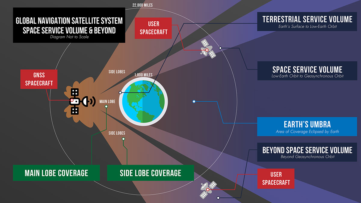
    Spacecraft near Earth have long relied on GNSS signals for PNT data. Spacecraft in low-Earth orbit below about 1,800 miles (3,000 km) in altitude can calculate their location using GNSS signals just as users on the ground might use their phones to navigate.

    This provides enormous benefits to these missions, allowing many satellites the autonomy to react and respond to unforeseen events in real time, ensuring the safety of the mission. GNSS receivers can also negate the need for an expensive onboard clock and simplifies ground operations, both of which can save missions money. Additionally, GNSS accuracy can help missions take precise measurements from space.

    Expanding the Space Service Volume

    his photograph of a nearly full Moon was taken from the Apollo 8 spacecraft at a point above 70 degrees east longitude. Mare Crisium, the circular, dark-colored area near the center, is near the eastern edge of the Moon as viewed from Earth. (Credits: NASA)
    This photograph of a nearly full Moon was taken from the Apollo 8 spacecraft at a point above 70 degrees east longitude. Mare Crisium, the circular, dark-colored area near the center, is near the eastern edge of the Moon as viewed from Earth. (Image: NASA)

    Beyond 1,800 miles in altitude, navigation with GNSS becomes more challenging. This expanse of space is called the Space Service Volume, which extends from 1,800 miles up to about 22,000 miles (36,000 km), or geosynchronous orbit. At altitudes beyond the GNSS constellations themselves users must begin to rely on signals received from the opposite side of the Earth.

    From the opposite side of the globe, Earth blocks much of the GNSS signals, so spacecraft in the Space Service Volume must instead “listen” for signals that extend out over the Earth. These signals extend out at an angle from GNSS antennas.

    Formally, GNSS reception in the Space Service Volume relies on signals received within about 26 degrees from the antennas’ strongest signal. However, NASA has had marked success using weaker GNSS side lobe signals — which extend out at an even greater angle from the antennas — for navigation in and beyond the Space Service Volume.

    Since the 1990s, NASA engineers have worked to understand the capabilities of these side lobes. In preparation for launch of the first Geostationary Operational Environmental Satellite-R weather satellite in 2016, NASA endeavored to better document side lobes’ strength and nature to determine if the satellite could meet its PNT requirements.

    “Through early on-orbit measurement and documentation of the GNSS side lobe capabilities, future missions could rest assured that their PNT needs would be met,” said Frank Bauer, who began the GNSS PNT effort at NASA’s Goddard Space Flight Center in Greenbelt, Maryland. “Our understanding of these signal patterns revealed a host of potential new GNSS applications.”

    Navigation experts at Goddard reverse-engineered the characteristics of the antennas on GPS satellites by observing the signals from space. By studying the signals satellites received from GPS side lobes, engineers pieced together their structure and strength. Using this data, they developed detailed models of the radiation patterns of GPS satellites in an effort called the GPS Antenna Characterization Experiment.

    While documenting these characteristics, NASA explored the feasibility of using side lobe signals for navigation well outside what had been considered the Space Service Volume and in lunar space. In recent years, the Magnetospheric Multiscale Mission (MMS) has even successfully determined its position using GPS signals at distances nearly halfway to the Moon.

    A graphic detailing the different areas of GNSS coverage. (Credits: NASA)
    A graphic detailing the different areas of GNSS coverage. (Image: NASA)

    GNSS at the Moon

    To build on the success of MMS, NASA navigation engineers have been simulating GNSS signal availability near the Moon. Their research indicates that these GNSS signals can play a critical role in NASA’s ambitious lunar exploration initiatives, providing unprecedented accuracy and precision.

    “Our simulations show that GPS can be extended to lunar distances by simply augmenting existing high-altitude GPS navigation systems with higher-gain antennas on user spacecraft,” said NASA navigation engineer Ben Ashman. “GPS and GNSS could play an important role in the upcoming Artemis missions from launch through lunar surface operations.”

    While MMS relied solely on GPS, NASA is working toward an interoperable approach that would allow lunar missions to take advantage of multiple constellations at once. Spacecraft near Earth receive enough signals from a single PNT constellation to calculate their location. However, at lunar distances GNSS signals are less numerous. Simulations show that using signals from multiple constellations would improve missions’ ability to calculate their location consistently.

    To prove and test this capability at the Moon, NASA is planning the Lunar GNSS Receiver Experiment (LuGRE), developed in partnership with the Italian Space Agency. LuGRE will fly on one of NASA’s Commercial Lunar Payload Services missions. These missions rely on U.S. companies to deliver lunar payloads that advance science and exploration technologies.

    NASA plans to land LuGRE on the Moon’s Mare Crisium basin in 2023. There, LuGRE is expected to obtain the first GNSS fix on the lunar surface. LuGRE will receive signals from both GPS and Galileo, the GNSS operated by the European Union. The data gathered will be used to develop operational lunar GNSS systems for future missions to the Moon.

  • Sentinel-6 sea-level mission to use GNSS-RO for weather and climate monitoring

    Sentinel-6 sea-level mission to use GNSS-RO for weather and climate monitoring

    To get the best measurements of Earth’s atmosphere, you sometimes have to leave it. This November, the Sentinel-6 Michael Freilich spacecraft will do just that.

    News from the Jet Propulsion Laboratory

    When a satellite by the name of Sentinel-6 Michael Freilich launches this November, its primary focus will be to monitor sea-level rise with extreme precision. But an instrument aboard the spacecraft will also provide atmospheric data that will improve weather forecasts, track hurricanes and bolster climate models.

    “Our fundamental goal with Sentinel-6 is to measure the oceans, but the more value we can add, the better,” said Josh Willis, the mission’s project scientist at NASA’s Jet Propulsion Laboratory in Southern California. “It’s not every day that we get to launch a satellite, so collecting more useful data about our oceans and atmosphere is a bonus.”

    A U.S.-European collaboration, Sentinel-6 Michael Freilich is one of two satellites that compose the Copernicus Sentinel-6/Jason-CS (Continuity of Service) mission. The satellite’s twin, Sentinel-6B, will launch in 2025 to take over for its predecessor. Together, the spacecraft will join TOPEX/Poseidon and the Jason series of satellites, which have been gathering precise sea-level measurements for nearly three decades. Once in orbit, each Sentinel-6 satellite will collect sea-level measurements down to the centimeter for 90% of the world’s oceans.

    JPL-developed instrument

    Meanwhile, they’ll also peer deep into Earth’s atmosphere with GNSS-RO to collect highly accurate global temperature and humidity information. Developed by JPL, the spacecraft’s GNSS-RO instrument tracks radio signals from navigation satellites to measure the physical properties of Earth’s atmosphere. As a radio signal passes through the atmosphere, it slows, its frequency changes, and its path bends. Called refraction, this effect can be used by scientists to measure minute changes in atmospheric physical properties, such as density, temperature, and moisture content.

    The precise global atmospheric measurements made by Sentinel-6 Michael Freilich will complement atmospheric observations by other GNSS-RO instruments already in space. Specifically, the National Oceanic and Atmospheric Administration’s National Weather Service meteorologists will use insights from Sentinel 6’s GNSS-RO to improve weather forecasts.

    Also, the GNSS-RO information will provide long-term data that can be used both to monitor how our atmosphere is changing and to refine models used for making projections of future climate. Data from this mission will help track the formation of hurricanes and support models to predict the direction storms may travel. The more data we gather about hurricane formation (and where a storm might make landfall), the better in terms of helping local efforts to mitigate damage and support evacuation plans.

    The Sentinel-6 Michael Freilich spacecraft undergoes tests at its manufacturer Airbus in Friedrichshafen, Germany, in 2019. The white GNSS-RO instrument can be seen attached to the upper left portion of the front of the spacecraft. (Photo: Airbus)
    The Sentinel-6 Michael Freilich spacecraft undergoes tests at its manufacturer Airbus in Friedrichshafen, Germany, in 2019. The white GNSS-RO instrument can be seen attached to the upper left portion of the front of the spacecraft. (Photo: Airbus)

    A brief history of radio occultation

    Radio occultation was first used by NASA’s Mariner 4 mission in 1965 when the spacecraft flew past Mars. As it passed behind the Red Planet from our perspective, scientists on Earth detected slight delays in its radio transmissions as they traveled through atmospheric gases. By measuring these radio signal delays, they were able to gain the first measurements of the Martian atmosphere and discover just how thin it was compared to Earth’s.

    By the 1980s, scientists had started to measure the slight delays in radio signals from Earth-orbiting navigation satellites to better understand our planet’s atmosphere. Since then, many radio occultation instruments have been launched; Sentinel-6 Michael Freilich will join the six COSMIC-2 satellites as the most advanced GNSS-RO instruments among them.

    “The Sentinel-6 instrument is essentially the same as COSMIC-2’s. Compared to other radio occultation instruments, they have higher measurement precision and greater atmospheric penetration depth,” said Chi Ao, the instrument scientist for GNSS-RO at JPL.

    GNSS-RO basics

    The GNSS-RO instrument’s receivers track navigation satellite radio signals as they dip below, or rise from, the horizon. They can detect these signals through the vertical extent of the atmosphere — through thick clouds — from the very top and almost all the way to the ground. This is important, because weather phenomena emerge from all layers of the atmosphere, not just from near Earth’s surface where we experience their effects.

    “Tiny changes in the radio signal can be measured by the instrument, which relate to the density of the atmosphere,” said Ao. “We can then precisely determine the temperature, pressure, and humidity through the layers of the atmosphere, which give us incredible insights to our planet’s dynamic climate and weather.”


    With the help of JPL’s GNSS-RO principal investigator Chi Ao and NOAA’s National Weather Service meteorologist Mark Jackson, this video explains how the GNSS-RO instrument aboard Sentinel-6 Michael Freilich will be used by meteorologists to improve weather forecasting predictions. (Credit: NASA/JPL-Caltech)


    But there’s another reason why probing the entire vertical profile of the atmosphere from orbit is so important: accuracy. Meteorologists typically gather information from a variety of sources – from weather balloons to instruments aboard aircraft. But sometimes scientists need to compensate for biases in the data. For example, air temperature readings from a thermometer on an airplane can be skewed by heat radiating from parts of the aircraft.

    GNSS-RO data is different. The instrument collects navigation satellite signals at the top of the atmosphere, in what is close to a vacuum. Although there are sources of error in every scientific measurement, at that altitude, there’s no refraction of the signal, which means there’s an almost bias-free baseline to which atmospheric measurements can be compared in order to minimize noise in data collection.

    And as one of the most advanced GNSS radio occultation instruments in orbit, said Ao, it will also be one of the most accurate atmospheric thermometers in space.

    More on the mission

    Copernicus Sentinel-6/Jason-CS is being jointly developed by the European Space Agency (ESA), the European Organisation for the Exploitation of Meteorological Satellites (EUMETSAT), NASA, and the National Oceanic and Atmospheric Administration (NOAA), with funding support from the European Commission and support from France’s National Centre for Space Studies (CNES).

    The first Sentinel-6/Jason-CS satellite that will launch was named after the former director of NASA’s Earth Science Division, Michael Freilich. It will follow the most recent U.S.-European sea-level observation satellite, Jason-3, which launched in 2016 and is currently providing data.

    NASA’s contributions to the Sentinel-6/Jason-CS mission are three science instruments for each of the two Sentinel-6 satellites: the Advanced Microwave Radiometer, the GNSS-RO, and the Laser Retroreflector Array. NASA is also contributing launch services, ground systems supporting operation of the NASA science instruments, the science data processors for two of these instruments, and support for the international Ocean Surface Topography Science Team.

  • NOAA report supports GNSS-RO for weather and space forecasts

    NOAA report supports GNSS-RO for weather and space forecasts

    Image: NOAA
    Image: NOAA

    On June 26, the U.S. National Oceanic and Atmospheric Administration (NOAA) released the summary of the results of Commercial Weather Data Pilot (CWDP) Round 2. View the summary here.

    In Round 2, NOAA evaluated GNSS radio occultation data from two U.S. commercial space companies: GeoOptics and Spire. NOAA concludes that, based on the results of CWDP Round 2, the commercial sector is able to provide radio occultation data that can support NOAA’s operational products and services.

    “As a result, NOAA is proceeding with plans to acquire commercial RO data for operational use,” the summary states.

    According to GeoOptics, the report highlights the unique qualities of its commercial GNSS-RO data and its ability to improve weather and space weather forecasts around the world.

    “As today’s report demonstrates, commercial satellite data will enable NOAA to make significant improvements in forecasting worldwide within the consistent budget limitations under which it operates,” said GeoOptics CEO Conrad Lautenbacher.

    NOAA anticipates release of a request for proposals soon for operational purchase of commercial radio occultation data, continuing an acquisition process that began in April with NOAA’s release of a draft Statement of Work.

    NOAA has requested $15 million in FY 2021 to support Commercial Data Purchase. The FY 2021 Budget also requests $8 million for CWDP to investigate new commercial technologies beyond radio occultation.

    By moving into this next phase of engagement with U.S. industry, NOAA is leveraging commercial space sector capabilities to support its operational products and services and to continue to improve its weather forecasting capabilities. NOAA plans to implement additional rounds of the CWDP to evaluate commercial capabilities beyond radio occultation data for potential operational use.

  • ESA’s Pioneer mission sends GNSS-RO nanosatellites into orbit

    ESA’s Pioneer mission sends GNSS-RO nanosatellites into orbit

    News from the European Space Agency (ESA)

    Two tiny GNSS-RO nanosatellites now circle the Earth, ready for action. The first European Pioneer mission lifted off Nov. 29 from Sriharikota, India, to put the satellites into orbit.

    One of Spire's Satellite Manufacturing Technicians (Tomasz Chanusiak) tests the Radio Frequency capabilities of a LEMUR2 nanosatellite in Spire's cleanroom in Glasgow, Scotland. (Photo: ESA)
    One of Spire’s Satellite Manufacturing Technicians (Tomasz Chanusiak) tests the Radio Frequency capabilities of a LEMUR2 nanosatellite in Spire’s cleanroom in Glasgow, Scotland. (Photo: ESA)

    The shoebox-sized satellites were launched at 04:27 GMT into low Earth orbit by the Indian Space Research Organisation’s PLSV launcher, and opened their first communication windows with their owner, Spire Global, less than an hour after they separated from the rocket.

    Both satellites were developed under ESA’s ARTES Pioneer programme, and will aim to prove the value of using nanosats for space-based GNSS Radio Occultation (GNSS-RO).

    GNSS-RO. GNSS-RO is the process of using satellites to measure how GNSS signals are refracted by the Earth’s atmosphere. Experts can use these measurements to glean temperature, pressure and humidity information for weather forecasting and climate change monitoring.

    In contrast, weather data gathered by weather balloons and aircraft can only reach certain altitudes, leaving the higher atmospheric layers untouched.

    Satellites have no such restrictions. They can gather massive amounts of this data from the ground up to the mesosphere as they fly over the Earth. This is usually done by large satellites. Spire’s nanosatellites weigh just 5 kg each, and were assembled and tested entirely by Spire in under three months, at their headquarters in Glasgow, Scotland.

    Named “Space as a Service,” the Spire Pioneer mission intends to prove that nanosat GNSS-RO is a commercially viable alternative to traditional methods.

    Photo:
    Two nanosatellites built by Spire Global were launched into low Earth orbit Nov. 29. (Photo: ISRO)

    The two tiny satellites will collect and distribute GNSS-RO data during their commissioning phase, after which they will go into full commercial data production mode, gathering weather information for meteorological institutions, maritime and aviation customers on demand.

    ESA’s Pioneer initiative partners with companies like Spire to help them provide this kind of in-orbit demonstration and validation for third parties.

    “We saw a gap in the market for what we call space mission providers: companies that offer all aspects of a space mission to validate a new technology or service for the benefit of others,” said ESA Pioneer Programme Manager Khalil Kably. “ESA is always looking to champion innovation in the space industry, and the idea of Pioneer is that these space mission providers can help this by being a one-stop shop for in-orbit demonstration and therefore reduce the barriers and complexity that can stifle new ideas.”

    “Spire has been focused on developing unique data sources with high frequency updates for the entire Earth and has over 60 LEMUR-2 class satellites deployed in space complimented with a global ground station network,” Spire Global CEO Peter Platzer said. “Under Pioneer, we can offer our extensive experience in manufacturing and managing small spacecraft like these to those who cannot afford to waste money and time doing it themselves. This work with ESA helps further support the global development of commercial aerospace’s potential to make space access universal.”

    “These incredibly clever shoebox-sized satellites built in Glasgow could slash the complexity and cost of access to space, presenting an exciting opportunity for the UK to thrive in the commercial space age,” UK Space Agency Chief Executive Graham Turnock said. “Through our £4m development funding, the government’s Industrial Strategy and by working closely with our international partners, we are helping UK businesses transform their ideas into commercial realities, resulting in jobs, growth and innovation.”

  • Severe Weather Study Shows Potential of GNSS-RO Satellites

    Severe Weather Study Shows Potential of GNSS-RO Satellites

    Constellation Roll-Out to Begin This Year

    GeoOptics, a satellite-based environmental data services company, in cooperation with Atmospheric and Environmental Research (AER), an environmental research and development company, has announced the initial results of an Observing System Simulation Experiment (OSSE) showing the reliability of radio occultation data in improving predictions of severe weather and flash flood events.

    Using weather prediction models and data assimilation techniques, AER evaluated the potential benefit of observing Earth’s atmosphere with a vast future constellation of many hundreds of orbiting GNSS – Radio Occultation (GNSS-RO) receivers. As a case study, the model used the convective system that brought severe weather to Oklahoma in 2013, which included an Enhanced Fujita Scale-3 tornado and heavy rains.

    “The improved characterization of moisture in the lowest 4-5 km of the atmosphere is very significant and, working with our colleagues at AER, we believe quite a rigorous scientific conclusion,” said Conrad Lautenbacher, GeoOptics CEO. “We see commercial provision of GNSS-RO as a valuable complement to public sector systems and a reliable, low-cost way to achieve the levels of scale tested. We are very excited by the results.”

    Through collaboration begun in 2014, the two companies set out to assess the impact of vastly increased numbers of GNSS-RO profiles on regional weather forecasting within the context of a global weather satellite system. Oklahoma was the region of focus of the study, an area with a history of severe weather phenomena. Today’s total global GNSS-RO profiles number approximately 1,800 per day, of which 0.64 profiles per day are readings taken over Oklahoma.

    In the study, AER and GeoOptics modeled from 50,000 to 2,000,000 global profiles per day through the deployment of the planned CICERO satellite constellation. Such large scale would correspondingly increase the profiles per day over Oklahoma to between 17 and 700.

    GPS World discussed the use of GPS for radio occultation in its March 1994 Innovation column, “Monitoring the Earth’s Atmosphere with GPS,” by Rob Kursinski.

    “We see commercial remote sensing and particularly the GNSS-RO technology as a paradigm change in developing and maintaining a cost-effective, next-generation operational observational infrastructure for environmental prediction,” said AER President Ron Isaacs. “The superb GNSS-RO technology knowledge base at GeoOptics provides an ideal and exciting complement to AER’s decades-long experience in today’s operational remote sensing and weather prediction practices, which include the current use of GNSS-RO sensing.”

    GNSS-RO profiles provide measurements of atmospheric temperature, moisture, and pressure with a precision unrivaled by other space-based techniques. The RO sensor gathers this information by precisely observing perturbations imposed on ubiquitous GPS radio signals as they pass through the atmosphere. Today, nearly 3,000 organizations in more than 80 countries use RO data in Numerical Weather Prediction (NWP) and research. NOAA’s own studies show that more accurate mid- to long-term forecasts can be made up to 15 hours sooner using the data collected from the current limited set of experimental GPS-RO sensors.

    GeoOptics plans to launch an array of powerful GNSS-RO sensors on its CICERO constellation of low-Earth-orbiting satellites. The rollout of the constellation will begin in the third quarter of 2015 and will deliver more than 50,000 global profiles per day when fully deployed. As demand grows, the 24-satellite CICERO constellation will be expanded to carry additional and complementary instruments, such as scatterometry and gravity sensors.

    “GeoOptics will advance a small satellite observing model that starts with GPS radio occultation,” Lautenbacher added. “We believe an integrated private company like ours can deploy such systems for a fraction of current costs to the government.”

    Figure 1. "Nature Run" atmospheric water vapor at about 4,000 feet above the ground.  The yellow-to-red color scale (bottom of figure) indicates how much water vapor is present, i.e., yellow is dry and red is moist.  This realization of atmosphere moisture during an Oklahoma severe weather outbreak in May 2013 is the yardstick against which our assimilation experiments are compared for realism.  It has a horizontal resolving power of about 1 1/4 mile (i.e., 2 km).
    Figure 1. “Nature Run” (the truth reference) atmospheric water vapor at about 4,000 feet above the ground. The yellow-to-red color scale (bottom of figure) indicates how much water vapor is present, i.e., yellow is dry and red is moist. This realization of atmosphere moisture during an Oklahoma severe weather outbreak in May 2013 is the yardstick against which our assimilation experiments are compared for realism. It has a horizontal resolving power of about 1 1/4 mile (i.e., 2 km).
    Figure 2. Atmospheric water vapor analysis using conventional observing system.  Valid time, vertical level and color scale are the same as in Figure 1.  Note that the data fusion experiments use a bigger grid than the Nature Run (Figure 1) with a horizontal resolving power of about 11 miles (i.e., 18 km).
    Figure 2. Atmospheric water vapor analysis using conventional observing system. Valid time, vertical level and color scale are the same as in Figure 1. Note that the data fusion experiments use a bigger grid than the Nature Run (Figure 1) with a horizontal resolving power of about 11 miles (i.e., 18 km).
    Figure 3. Atmospheric water vapor analysis using conventional observing system + CICERO radio occultation observations.  The distribution of water vapor in this analysis is much closer to the Nature Run (Fig. 1) in pattern and magnitude than the Control result (Fig. 2).
    Figure 3. Atmospheric water vapor analysis using conventional observing system + CICERO radio occultation observations. The distribution of water vapor in this analysis is much closer to the Nature Run (Fig. 1) in pattern and magnitude than the Control result (Fig. 2).